
 Search
Thursday's Mothrazilla, Part II: First Forecast
Page 2 of 18 •  1, 2, 3 ... 10 ... 18
 ![]()
Re: Thursday's Mothrazilla, Part II: First Forecast
![]() by Frank_Wx Tue Feb 16, 2021 10:12 pm
by Frank_Wx Tue Feb 16, 2021 10:12 pm
18z
00z
Run hasn’t finished
Frank_Wx- Godzilla Seeker

- Posts : 21305
Join date : 2013-01-05 -

Re: Thursday's Mothrazilla, Part II: First Forecast
![]() by Fededle22 Tue Feb 16, 2021 10:22 pm
by Fededle22 Tue Feb 16, 2021 10:22 pm
Fededle22- Posts : 169
Join date : 2013-03-08
Re: Thursday's Mothrazilla, Part II: First Forecast
![]() by amugs Tue Feb 16, 2021 10:22 pm
by amugs Tue Feb 16, 2021 10:22 pm

JMAN its a long duration storm
_________________
Mugs
AKA:King: Snow Weenie
Self Proclaimed
WINTER 2014-15 : 55.12" +.02 for 6 coatings (avg. 35")
WINTER 2015-16 Total - 29.8" (Avg 35")
WINTER 2016-17 : 39.5" so far

amugs- Advanced Forecaster - Mod

- Posts : 15095
Reputation : 213
Join date : 2013-01-07
Age : 54
Location : Hillsdale,NJ
Re: Thursday's Mothrazilla, Part II: First Forecast
![]() by Frank_Wx Tue Feb 16, 2021 10:31 pm
by Frank_Wx Tue Feb 16, 2021 10:31 pm
Fededle22 wrote:Great potential for this storm and looking forward to what it does. Great write up Frank as usual. What are looking at with timing? Start-Finish? It's looking like it may continue into Friday as well.
Depends
If the storm consists of just the WAA then 9am-4pm
If the storm consists of WAA and CCB then 9am-9am
_________________
_______________________________________________________________________________________________________
CLICK HERE to view NJ Strong Snowstorm Classifications

Frank_Wx- Godzilla Seeker
- Posts : 21305
Reputation : 328
Join date : 2013-01-05
Age : 32
Location : Jersey City, NJ -
Re: Thursday's Mothrazilla, Part II: First Forecast
![]() by sroc4 Wed Feb 17, 2021 6:48 am
by sroc4 Wed Feb 17, 2021 6:48 am
.SHORT TERM /6 PM THIS EVENING THROUGH FRIDAY/...
The focus this period shifts to another southern branch storm
system that will interact with a polar airmass across the
region, continuing in what has been an active month.
A departing polar vortex across eastern Canada and a deep-
layered SW flow emanating from the southern branch longwave
trough over the Plains will provide confluent flow to the north,
allowing polar high pressure to strengthen across the NE
tonight. At the same time, an active frontal zone along the
eastern Gulf of Mexico, extending along the SE and Mid Atlantic
coasts, will funnel a series of lows that will pass south and
east of the area Thursday into Friday. Ahead of the first wave,
snow will break out from SW to NE Thursday morning into the
afternoon.
Guidance continues to trend colder with the system with the low
track generally near the 40n...70W benchmark. However, global
models are in good agreement with a long period of light to
occasionally moderate snow through Friday as multiple waves
passes to the SE. The NAM remains an outlier with strong
frontogenetic banding to the NW of the first low on Thursday
with the potential for heavy snow, especially along the coast.
It produces liquid equivalent amounts of a half inch at the far
NW corner of the Lower Hudson Valley to over an inch across the
NYC metro and LI by early Thursday evening. There is also a
strong upper jet to the NW of the area. However, in assessing
the guidance, the better jet dynamics appear to come in Friday
as the RRQ of the upper jet approaches. Additionally, while
there is a strong baroclinic zone to the NW of the low track,
the low is fairly weak and the best thermal forcing may reside
just south of the area. Overall,the NAM seems to be overdone
with the lift, but at the same time it has been consistent over
the last several runs. Still though, it like the global models
has continued to shift to the south with the frontal zone and
low tracks. This will have to be watched closely today to see if
it falls into the consensus with a longer, drawn out snowfall
event. In fact, much of the guidance points to snowfall amounts
of 6 to 8 inches across the area, but over a 24 to 36h period.
Warning criteria is 6 inches or more in 12h, or 8 inches or
more in 24h. The latter is looking more likely at this time.
Additionally. the ECMWF and GGEM indicate some of this snow
could hang on into Friday evening/night as the last piece of
southern branch energy kicks out. The GGEM even brings moderate
to heavy snow into eastern LI/SE CT. Thus, the Winter Storm
Watch has been extended into Friday.
As for ptype, this is looking to be a mainly snow event with
perhaps some mixing with sleet across LI and the NYC metro
Thursday night into Friday. If that does not happen, the higher
snowfall totals could very well be at the coast. For now,
going with a uniform 4 to 8 inches across the entire forecast
area.
_________________
"In weather and in life, there's no winning and losing; there's only winning and learning."
WINTER 2012/2013 TOTALS 43.65"WINTER 2017/2018 TOTALS 62.85" WINTER 2022/2023 TOTALS 4.9"
WINTER 2013/2014 TOTALS 64.85"WINTER 2018/2019 TOTALS 14.25" WINTER 2023/2024 TOTALS 13.1"
WINTER 2014/2015 TOTALS 71.20"WINTER 2019/2020 TOTALS 6.35"
WINTER 2015/2016 TOTALS 35.00"WINTER 2020/2021 TOTALS 37.75"
WINTER 2016/2017 TOTALS 42.25"WINTER 2021/2022 TOTALS 31.65"

sroc4- Admin
- Posts : 8354
Reputation : 302
Join date : 2013-01-07
Location : Wading River, LI
Re: Thursday's Mothrazilla, Part II: First Forecast
![]() by heehaw453 Wed Feb 17, 2021 7:13 am
by heehaw453 Wed Feb 17, 2021 7:13 am
I like what Mt Holly and Upton have for now.


heehaw453- Advanced Forecaster

- Posts : 3906
Reputation : 86
Join date : 2014-01-20
Location : Bedminster Township, PA Elevation 600' ASL
CPcantmeasuresnow likes this post
Re: Thursday's Mothrazilla, Part II: First Forecast
![]() by jmanley32 Wed Feb 17, 2021 8:44 am
by jmanley32 Wed Feb 17, 2021 8:44 am

jmanley32- Senior Enthusiast

- Posts : 20535
Reputation : 108
Join date : 2013-12-12
Age : 43
Location : Yonkers, NY
Re: Thursday's Mothrazilla, Part II: First Forecast
![]() by sroc4 Wed Feb 17, 2021 9:15 am
by sroc4 Wed Feb 17, 2021 9:15 am
jmanley32 wrote:GM all so after reading the Upton discussion it appears the NAM is being discounted for tgat heavy banding front end thump? And this may end up being a long WWA for 6 to 8 inches over 36 hrs? That's pretty darn light snow. I'd like to hear what Frank's take on that is cuz he was talking about a super heavy area for a period. I thought at this point the hi res models would be do better than globals. Guess we will see.
Certainly not discounted Jon but taken as an outlier since it is regarding its temp profiles and strength of vertical lifting. That said is has been consistent in its runs including 12z today. Cant discount consistency.
_________________
"In weather and in life, there's no winning and losing; there's only winning and learning."
WINTER 2012/2013 TOTALS 43.65"WINTER 2017/2018 TOTALS 62.85" WINTER 2022/2023 TOTALS 4.9"
WINTER 2013/2014 TOTALS 64.85"WINTER 2018/2019 TOTALS 14.25" WINTER 2023/2024 TOTALS 13.1"
WINTER 2014/2015 TOTALS 71.20"WINTER 2019/2020 TOTALS 6.35"
WINTER 2015/2016 TOTALS 35.00"WINTER 2020/2021 TOTALS 37.75"
WINTER 2016/2017 TOTALS 42.25"WINTER 2021/2022 TOTALS 31.65"
sroc4- Admin
- Posts : 8354
Reputation : 302
Join date : 2013-01-07
Location : Wading River, LI
Re: Thursday's Mothrazilla, Part II: First Forecast
![]() by Frank_Wx Wed Feb 17, 2021 9:22 am
by Frank_Wx Wed Feb 17, 2021 9:22 am


_________________
_______________________________________________________________________________________________________
CLICK HERE to view NJ Strong Snowstorm Classifications
Frank_Wx- Godzilla Seeker
- Posts : 21305
Reputation : 328
Join date : 2013-01-05
Age : 32
Location : Jersey City, NJ -
Re: Thursday's Mothrazilla, Part II: First Forecast
![]() by jmanley32 Wed Feb 17, 2021 9:23 am
by jmanley32 Wed Feb 17, 2021 9:23 am
I agree I hope we see a period of heavy snow if it's light I dunno how much will accumulate other than on top snow as it was super muddy here but it's 24 now so that prolly hardened up. Will be interesting to see how this pans put. Kinda a weird set up.sroc4 wrote:jmanley32 wrote:GM all so after reading the Upton discussion it appears the NAM is being discounted for tgat heavy banding front end thump? And this may end up being a long WWA for 6 to 8 inches over 36 hrs? That's pretty darn light snow. I'd like to hear what Frank's take on that is cuz he was talking about a super heavy area for a period. I thought at this point the hi res models would be do better than globals. Guess we will see.
Certainly not discounted Jon but taken as an outlier since it is regarding its temp profiles and strength of vertical lifting. That said is has been consistent in its runs including 12z today. Cant discount consistency.
jmanley32- Senior Enthusiast
- Posts : 20535
Reputation : 108
Join date : 2013-12-12
Age : 43
Location : Yonkers, NY
Re: Thursday's Mothrazilla, Part II: First Forecast
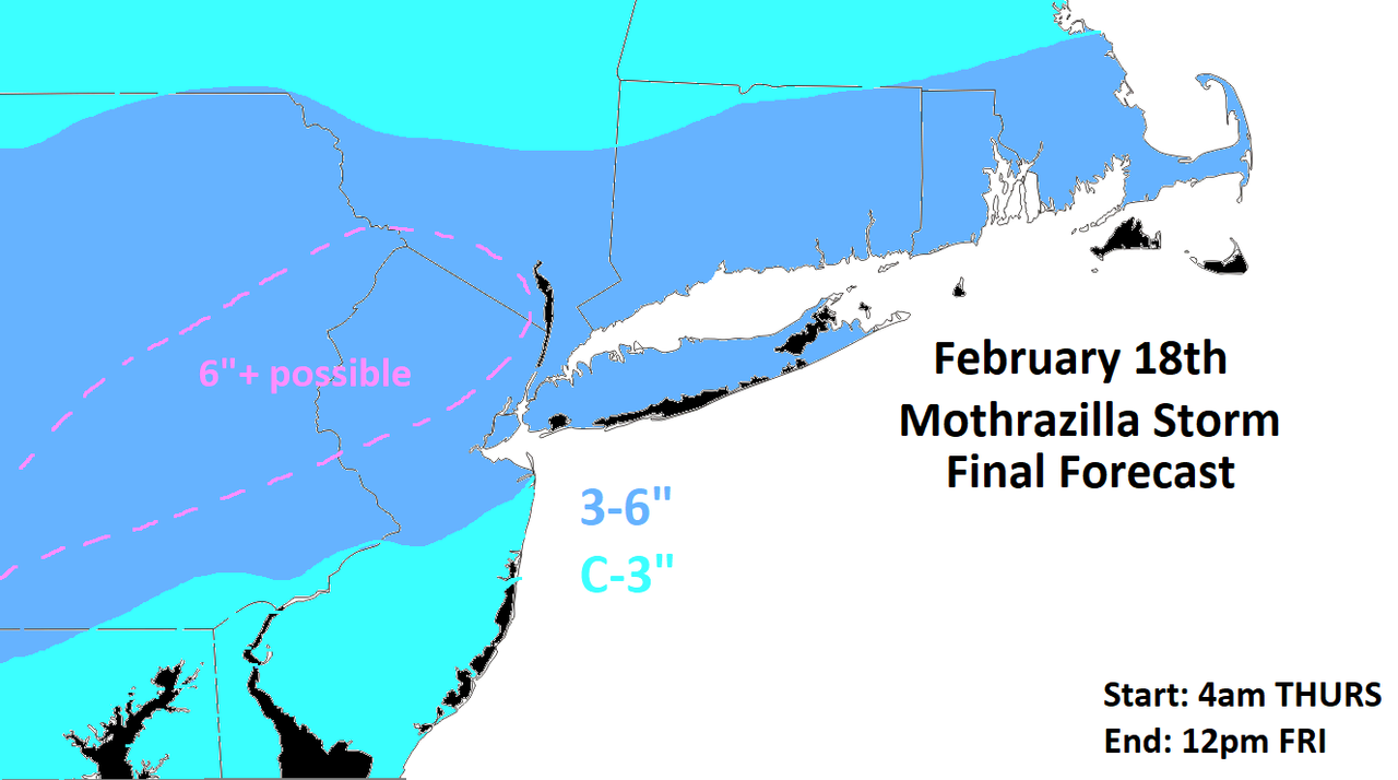
![]() by Frank_Wx Wed Feb 17, 2021 9:42 am
by Frank_Wx Wed Feb 17, 2021 9:42 am

My updated snow map:
_________________
_______________________________________________________________________________________________________
CLICK HERE to view NJ Strong Snowstorm Classifications
Frank_Wx- Godzilla Seeker
- Posts : 21305
Reputation : 328
Join date : 2013-01-05
Age : 32
Location : Jersey City, NJ -
Re: Thursday's Mothrazilla, Part II: First Forecast
![]() by jmanley32 Wed Feb 17, 2021 9:43 am
by jmanley32 Wed Feb 17, 2021 9:43 am
looks like nam backed off on the totals by a few to several inches but still within ur map area and amount, do u think theres still a chance somewhere sees 12+ or do u think the NWS is right in that the qpf is too high. Are you in FL now? If so kudos to stay on this for us even on vacation, don't party too hard hahaFrank_Wx wrote:12z NAM
OMG its wed. duhh. wow that surely is a flurry at best for that long.
Last edited by jmanley32 on Wed Feb 17, 2021 9:48 am; edited 1 time in total
jmanley32- Senior Enthusiast
- Posts : 20535
Reputation : 108
Join date : 2013-12-12
Age : 43
Location : Yonkers, NY
Re: Thursday's Mothrazilla, Part II: First Forecast
![]() by jmanley32 Wed Feb 17, 2021 9:44 am
by jmanley32 Wed Feb 17, 2021 9:44 am
jmanley32- Senior Enthusiast
- Posts : 20535
Reputation : 108
Join date : 2013-12-12
Age : 43
Location : Yonkers, NY
Re: Thursday's Mothrazilla, Part II: First Forecast
![]() by Frank_Wx Wed Feb 17, 2021 9:48 am
by Frank_Wx Wed Feb 17, 2021 9:48 am
jmanley32 wrote:looks like nam backed off on the totals by a few to several inches but still within ur map area and amount, do u think theres still a chance somewhere sees 12+ or do u think the NWS is right in that the qpf is too high. Are you in FL now? If so kudos to stay on this for us even on vacation, don't party too hard hahaFrank_Wx wrote:12z NAM
Not yet, I leave for FL late Friday. I'll be there until the 28th.
As for 12+ - that is not likely and really never was. The highest I was thinking was 8-12, but those amounts will be concentrated to specific areas who benefit from the WAA (front end thump) of snow AND the CCB band that tries to develop late Thursday into Friday. The coast - ESE of 95 - is going to battle temperature issues.
_________________
_______________________________________________________________________________________________________
CLICK HERE to view NJ Strong Snowstorm Classifications
Frank_Wx- Godzilla Seeker
- Posts : 21305
Reputation : 328
Join date : 2013-01-05
Age : 32
Location : Jersey City, NJ -
Re: Thursday's Mothrazilla, Part II: First Forecast
![]() by heehaw453 Wed Feb 17, 2021 9:49 am
by heehaw453 Wed Feb 17, 2021 9:49 am
heehaw453- Advanced Forecaster
- Posts : 3906
Reputation : 86
Join date : 2014-01-20
Location : Bedminster Township, PA Elevation 600' ASL
Re: Thursday's Mothrazilla, Part II: First Forecast
![]() by Frank_Wx Wed Feb 17, 2021 9:50 am
by Frank_Wx Wed Feb 17, 2021 9:50 am
jmanley32 wrote:Well nvm frank haha, that stinks only 3-6 meh thanks for your efforts still. So no snow today in otherwords. 4am today? Its def not snowing since 4am. or 4pm today or 4am Friday morning, confused at the timing?
Today is Wednesday....

Although it seems long duration, the precip will be pretty light outside of some moderate bands from the WAA. Then the CCB wraps around Thursday night through Friday morning but I don't think that will be 100% snow for the coast.
_________________
_______________________________________________________________________________________________________
CLICK HERE to view NJ Strong Snowstorm Classifications
Frank_Wx- Godzilla Seeker
- Posts : 21305
Reputation : 328
Join date : 2013-01-05
Age : 32
Location : Jersey City, NJ -
Re: Thursday's Mothrazilla, Part II: First Forecast
![]() by jmanley32 Wed Feb 17, 2021 9:52 am
by jmanley32 Wed Feb 17, 2021 9:52 am
With ur new snow map it appears you feel its going to be well below the NAM amounts too? I mean u basiucally cut it in half, is there a chance that banding still happens? Its kinda odd how this got it really wrong 24 hrs out.Frank_Wx wrote:jmanley32 wrote:looks like nam backed off on the totals by a few to several inches but still within ur map area and amount, do u think theres still a chance somewhere sees 12+ or do u think the NWS is right in that the qpf is too high. Are you in FL now? If so kudos to stay on this for us even on vacation, don't party too hard hahaFrank_Wx wrote:12z NAM
Not yet, I leave for FL late Friday. I'll be there until the 28th.
As for 12+ - that is not likely and really never was. The highest I was thinking was 8-12, but those amounts will be concentrated to specific areas who benefit from the WAA (front end thump) of snow AND the CCB band that tries to develop late Thursday into Friday. The coast - ESE of 95 - is going to battle temperature issues.
jmanley32- Senior Enthusiast
- Posts : 20535
Reputation : 108
Join date : 2013-12-12
Age : 43
Location : Yonkers, NY
Re: Thursday's Mothrazilla, Part II: First Forecast
![]() by amugs Wed Feb 17, 2021 9:53 am
by amugs Wed Feb 17, 2021 9:53 am
sroc4 wrote:jmanley32 wrote:GM all so after reading the Upton discussion it appears the NAM is being discounted for tgat heavy banding front end thump? And this may end up being a long WWA for 6 to 8 inches over 36 hrs? That's pretty darn light snow. I'd like to hear what Frank's take on that is cuz he was talking about a super heavy area for a period. I thought at this point the hi res models would be do better than globals. Guess we will see.
Certainly not discounted Jon but taken as an outlier since it is regarding its temp profiles and strength of vertical lifting. That said is has been consistent in its runs including 12z today. Cant discount consistency.
AND it was the one first storm to see the warm tongue and show rain through NNJ before any other caught this. It has done very well with these storms and has ben consistent for 4 runs now on the jet dynamics and the evolution. RGEM has had it and now the GFS. EURO not so much and CANADIAN. EURO has had us cooler (last storm) and less snowier with storms - it has sniffed them out to back track on them but its EPS shows a snowier solution last night at 0Z. Lets see what the rest of the model suite brings into play here today.
_________________
Mugs
AKA:King: Snow Weenie
Self Proclaimed
WINTER 2014-15 : 55.12" +.02 for 6 coatings (avg. 35")
WINTER 2015-16 Total - 29.8" (Avg 35")
WINTER 2016-17 : 39.5" so far
amugs- Advanced Forecaster - Mod
- Posts : 15095
Reputation : 213
Join date : 2013-01-07
Age : 54
Location : Hillsdale,NJ
Re: Thursday's Mothrazilla, Part II: First Forecast
![]() by jmanley32 Wed Feb 17, 2021 9:53 am
by jmanley32 Wed Feb 17, 2021 9:53 am
yes i edited my comment to reflect that, im tired and been unemployed (well i work for myself right now, love being my own boss) so sometimes i do not realize what day it is especially first thing in morning.Frank_Wx wrote:jmanley32 wrote:Well nvm frank haha, that stinks only 3-6 meh thanks for your efforts still. So no snow today in otherwords. 4am today? Its def not snowing since 4am. or 4pm today or 4am Friday morning, confused at the timing?
Today is Wednesday....
Although it seems long duration, the precip will be pretty light outside of some moderate bands from the WAA. Then the CCB wraps around Thursday night through Friday morning but I don't think that will be 100% snow for the coast.
jmanley32- Senior Enthusiast
- Posts : 20535
Reputation : 108
Join date : 2013-12-12
Age : 43
Location : Yonkers, NY
Re: Thursday's Mothrazilla, Part II: First Forecast
![]() by amugs Wed Feb 17, 2021 9:55 am
by amugs Wed Feb 17, 2021 9:55 am
_________________
Mugs
AKA:King: Snow Weenie
Self Proclaimed
WINTER 2014-15 : 55.12" +.02 for 6 coatings (avg. 35")
WINTER 2015-16 Total - 29.8" (Avg 35")
WINTER 2016-17 : 39.5" so far
amugs- Advanced Forecaster - Mod
- Posts : 15095
Reputation : 213
Join date : 2013-01-07
Age : 54
Location : Hillsdale,NJ
Re: Thursday's Mothrazilla, Part II: First Forecast
![]() by jmanley32 Wed Feb 17, 2021 9:55 am
by jmanley32 Wed Feb 17, 2021 9:55 am
You didn't leave in time that's why it trended less, thanks for nothing!! LOL totally kidding.Frank_Wx wrote:jmanley32 wrote:looks like nam backed off on the totals by a few to several inches but still within ur map area and amount, do u think theres still a chance somewhere sees 12+ or do u think the NWS is right in that the qpf is too high. Are you in FL now? If so kudos to stay on this for us even on vacation, don't party too hard hahaFrank_Wx wrote:12z NAM
Not yet, I leave for FL late Friday. I'll be there until the 28th.
As for 12+ - that is not likely and really never was. The highest I was thinking was 8-12, but those amounts will be concentrated to specific areas who benefit from the WAA (front end thump) of snow AND the CCB band that tries to develop late Thursday into Friday. The coast - ESE of 95 - is going to battle temperature issues.
jmanley32- Senior Enthusiast
- Posts : 20535
Reputation : 108
Join date : 2013-12-12
Age : 43
Location : Yonkers, NY
Frank_Wx likes this post
Re: Thursday's Mothrazilla, Part II: First Forecast
![]() by Frank_Wx Wed Feb 17, 2021 11:07 am
by Frank_Wx Wed Feb 17, 2021 11:07 am

_________________
_______________________________________________________________________________________________________
CLICK HERE to view NJ Strong Snowstorm Classifications
Frank_Wx- Godzilla Seeker
- Posts : 21305
Reputation : 328
Join date : 2013-01-05
Age : 32
Location : Jersey City, NJ -
CPcantmeasuresnow likes this post
Re: Thursday's Mothrazilla, Part II: First Forecast
![]() by jmanley32 Wed Feb 17, 2021 12:11 pm
by jmanley32 Wed Feb 17, 2021 12:11 pm
wow dying out big time nyc area falls right in ur low end. Looking like a minor event at best, but we will see, things can happen as surprises.Frank_Wx wrote:GFS
jmanley32- Senior Enthusiast
- Posts : 20535
Reputation : 108
Join date : 2013-12-12
Age : 43
Location : Yonkers, NY
Re: Thursday's Mothrazilla, Part II: First Forecast
![]() by jmanley32 Wed Feb 17, 2021 12:14 pm
by jmanley32 Wed Feb 17, 2021 12:14 pm
jmanley32- Senior Enthusiast
- Posts : 20535
Reputation : 108
Join date : 2013-12-12
Age : 43
Location : Yonkers, NY
Re: Thursday's Mothrazilla, Part II: First Forecast
![]() by billg315 Wed Feb 17, 2021 12:47 pm
by billg315 Wed Feb 17, 2021 12:47 pm

billg315- Advanced Forecaster - Mod
- Posts : 4483
Reputation : 185
Join date : 2015-01-24
Age : 50
Location : Flemington, NJ
amugs likes this post
Re: Thursday's Mothrazilla, Part II: First Forecast
![]() by essexcountypete Wed Feb 17, 2021 1:02 pm
by essexcountypete Wed Feb 17, 2021 1:02 pm

essexcountypete- Pro Enthusiast

- Posts : 783
Reputation : 12
Join date : 2013-12-09
Location : Bloomfield, NJ
billg315 likes this post
Re: Thursday's Mothrazilla, Part II: First Forecast
![]() by Frank_Wx Wed Feb 17, 2021 1:08 pm
by Frank_Wx Wed Feb 17, 2021 1:08 pm
essexcountypete wrote:I think the only way we'll see the higher end totals would be to pool our cash and get Frank on an earlier flight. I see a few open seats on the red eye tonight
This actually is the only way, and I would be open to it
_________________
_______________________________________________________________________________________________________
CLICK HERE to view NJ Strong Snowstorm Classifications
Frank_Wx- Godzilla Seeker
- Posts : 21305
Reputation : 328
Join date : 2013-01-05
Age : 32
Location : Jersey City, NJ -
moleson likes this post
Page 2 of 18 • 1, 2, 3 ... 10 ... 18 ![]()
|
|
|