
 Search
Long Range Discussion 22.0
Page 25 of 31 •  1 ... 14 ... 24, 25, 26 ... 31
 ![]()
Re: Long Range Discussion 22.0
![]() by rb924119 Sun Jan 09, 2022 8:54 pm
by rb924119 Sun Jan 09, 2022 8:54 pm
heehaw453 wrote:amugs wrote:You guys are using OP 500mb maps a week out in this most volatile pattern with HUGE changes between the MJO in Phase 8, SOI crash, a cut off low in the Baja of Cali = Split Flow and STJ injection happening not to mention a NAO going Negative, EPO and PNA flipping with a PV entering the picture?
ENS peeps are teh way to go. In no way can one say this is a miss at the 15-17th time frame at this stage with all the aforementioned IMO.
Time will tell. GEFS and EURO ENS are showing some very good LP positions and indicy members. Just like Friday's storm models are going o struggle mightily until we are in a few days.
Time will tell but the Massive Ocean storm has a huge role in the follow up system. If that system doesn't exit quick enough than we may very miss the 15-17th but if it does than the follow up storm can come N.
Too early to bail on it. The issue I see on EPS guidance is the block isn't as strong especially west of the main east based block which allows the 50/50 low to slip away quickly. This gives room for the mid atlantic storm to move on out. The Canadian is a stronger block west of the east based block and keeps the mid atlantic storm at bay allowing it to mature below our latitude and be closer to the coast. The GEFS is closer to the Canadian but actually stronger blocking. The transient NAO IMO is the key and usually big storms for the northeast are most heavily waited on that feature. It's all about timing...
Top in Euro ensembles and bottom is GFS ensembles. That's a big difference.


Interesting view! I’m actually of an opposing view point. Kind of lol I think the block itself is displaced too far equatorward and the departing storm from the 13th is too slow. This combination will be compounded by hemispheric and tropical forcings to keep the height field too suppressed for storm on the 16th to gain sufficient latitude once it develops, and instead be forced straight out to sea.
rb924119- Meteorologist

- Posts : 6890
Join date : 2013-02-06
Re: Long Range Discussion 22.0
![]() by heehaw453 Sun Jan 09, 2022 9:05 pm
by heehaw453 Sun Jan 09, 2022 9:05 pm
rb924119 wrote:heehaw453 wrote:amugs wrote:You guys are using OP 500mb maps a week out in this most volatile pattern with HUGE changes between the MJO in Phase 8, SOI crash, a cut off low in the Baja of Cali = Split Flow and STJ injection happening not to mention a NAO going Negative, EPO and PNA flipping with a PV entering the picture?
ENS peeps are teh way to go. In no way can one say this is a miss at the 15-17th time frame at this stage with all the aforementioned IMO.
Time will tell. GEFS and EURO ENS are showing some very good LP positions and indicy members. Just like Friday's storm models are going o struggle mightily until we are in a few days.
Time will tell but the Massive Ocean storm has a huge role in the follow up system. If that system doesn't exit quick enough than we may very miss the 15-17th but if it does than the follow up storm can come N.
Too early to bail on it. The issue I see on EPS guidance is the block isn't as strong especially west of the main east based block which allows the 50/50 low to slip away quickly. This gives room for the mid atlantic storm to move on out. The Canadian is a stronger block west of the east based block and keeps the mid atlantic storm at bay allowing it to mature below our latitude and be closer to the coast. The GEFS is closer to the Canadian but actually stronger blocking. The transient NAO IMO is the key and usually big storms for the northeast are most heavily waited on that feature. It's all about timing...
Top in Euro ensembles and bottom is GFS ensembles. That's a big difference.
Interesting view! I’m actually of an opposing view point. Kind of lol I think the block itself is displaced too far equatorward and the departing storm from the 13th is too slow. This combination will be compounded by hemispheric and tropical forcings to keep the height field too suppressed for storm on the 16th to gain sufficient latitude once it develops, and instead be forced straight out to sea.
I totally can see that Rb. It's going to be interesting the next few days to see how guidance resolves this.
heehaw453- Advanced Forecaster

- Posts : 3906
Join date : 2014-01-20
rb924119 likes this post
Re: Long Range Discussion 22.0
![]() by amugs Sun Jan 09, 2022 9:11 pm
by amugs Sun Jan 09, 2022 9:11 pm


_________________
Mugs
AKA:King: Snow Weenie
Self Proclaimed
WINTER 2014-15 : 55.12" +.02 for 6 coatings (avg. 35")
WINTER 2015-16 Total - 29.8" (Avg 35")
WINTER 2016-17 : 39.5" so far

amugs- Advanced Forecaster - Mod

- Posts : 15093
Reputation : 213
Join date : 2013-01-07
Age : 54
Location : Hillsdale,NJ
Re: Long Range Discussion 22.0
![]() by rb924119 Sun Jan 09, 2022 9:21 pm
by rb924119 Sun Jan 09, 2022 9:21 pm
heehaw453 wrote:rb924119 wrote:heehaw453 wrote:amugs wrote:You guys are using OP 500mb maps a week out in this most volatile pattern with HUGE changes between the MJO in Phase 8, SOI crash, a cut off low in the Baja of Cali = Split Flow and STJ injection happening not to mention a NAO going Negative, EPO and PNA flipping with a PV entering the picture?
ENS peeps are teh way to go. In no way can one say this is a miss at the 15-17th time frame at this stage with all the aforementioned IMO.
Time will tell. GEFS and EURO ENS are showing some very good LP positions and indicy members. Just like Friday's storm models are going o struggle mightily until we are in a few days.
Time will tell but the Massive Ocean storm has a huge role in the follow up system. If that system doesn't exit quick enough than we may very miss the 15-17th but if it does than the follow up storm can come N.
Too early to bail on it. The issue I see on EPS guidance is the block isn't as strong especially west of the main east based block which allows the 50/50 low to slip away quickly. This gives room for the mid atlantic storm to move on out. The Canadian is a stronger block west of the east based block and keeps the mid atlantic storm at bay allowing it to mature below our latitude and be closer to the coast. The GEFS is closer to the Canadian but actually stronger blocking. The transient NAO IMO is the key and usually big storms for the northeast are most heavily waited on that feature. It's all about timing...
Top in Euro ensembles and bottom is GFS ensembles. That's a big difference.
Interesting view! I’m actually of an opposing view point. Kind of lol I think the block itself is displaced too far equatorward and the departing storm from the 13th is too slow. This combination will be compounded by hemispheric and tropical forcings to keep the height field too suppressed for storm on the 16th to gain sufficient latitude once it develops, and instead be forced straight out to sea.
I totally can see that Rb. It's going to be interesting the next few days to see how guidance resolves this.
Yeah, it should be fun! I just think that with that southward displaced NAO block, it’s too much of a good thing in conjunction with the storm from the 13th, basically, is where I stand. IF we could somehow get it out faster (possible), or have it not be there at all (not possible) with the NAO ridging unchanged, I’d have a much snowier opinion haha I just don’t think we will as of now.
Plenty of other chances coming, though, so even if this one doesn’t work out for us specifically, I’m not worried haha
rb924119- Meteorologist
- Posts : 6890
Reputation : 194
Join date : 2013-02-06
Age : 32
Location : Greentown, Pa
Re: Long Range Discussion 22.0
![]() by heehaw453 Sun Jan 09, 2022 9:36 pm
by heehaw453 Sun Jan 09, 2022 9:36 pm
rb924119 wrote:heehaw453 wrote:rb924119 wrote:heehaw453 wrote:amugs wrote:You guys are using OP 500mb maps a week out in this most volatile pattern with HUGE changes between the MJO in Phase 8, SOI crash, a cut off low in the Baja of Cali = Split Flow and STJ injection happening not to mention a NAO going Negative, EPO and PNA flipping with a PV entering the picture?
ENS peeps are teh way to go. In no way can one say this is a miss at the 15-17th time frame at this stage with all the aforementioned IMO.
Time will tell. GEFS and EURO ENS are showing some very good LP positions and indicy members. Just like Friday's storm models are going o struggle mightily until we are in a few days.
Time will tell but the Massive Ocean storm has a huge role in the follow up system. If that system doesn't exit quick enough than we may very miss the 15-17th but if it does than the follow up storm can come N.
Too early to bail on it. The issue I see on EPS guidance is the block isn't as strong especially west of the main east based block which allows the 50/50 low to slip away quickly. This gives room for the mid atlantic storm to move on out. The Canadian is a stronger block west of the east based block and keeps the mid atlantic storm at bay allowing it to mature below our latitude and be closer to the coast. The GEFS is closer to the Canadian but actually stronger blocking. The transient NAO IMO is the key and usually big storms for the northeast are most heavily waited on that feature. It's all about timing...
Top in Euro ensembles and bottom is GFS ensembles. That's a big difference.
Interesting view! I’m actually of an opposing view point. Kind of lol I think the block itself is displaced too far equatorward and the departing storm from the 13th is too slow. This combination will be compounded by hemispheric and tropical forcings to keep the height field too suppressed for storm on the 16th to gain sufficient latitude once it develops, and instead be forced straight out to sea.
I totally can see that Rb. It's going to be interesting the next few days to see how guidance resolves this.
Yeah, it should be fun! I just think that with that southward displaced NAO block, it’s too much of a good thing in conjunction with the storm from the 13th, basically, is where I stand. IF we could somehow get it out faster (possible), or have it not be there at all (not possible) with the NAO ridging unchanged, I’d have a much snowier opinion haha I just don’t think we will as of now.
Plenty of other chances coming, though, so even if this one doesn’t work out for us specifically, I’m not worried haha
The wave spacing on the GEFS is by the worst on the major globals and consequently it renders a rather weak storm as it doesn't have the space to amplify. So it's even possible east coast doesn't get a significant storm if it's that close. I've seen the light/moderate NAO's work magic especially on initial flexing/relaxing phases. What normally screws us is severe blocking whereby VA gets 1' and we get partly cloudy
heehaw453- Advanced Forecaster
- Posts : 3906
Reputation : 86
Join date : 2014-01-20
Location : Bedminster Township, PA Elevation 600' ASL
Re: Long Range Discussion 22.0
![]() by rb924119 Sun Jan 09, 2022 11:36 pm
by rb924119 Sun Jan 09, 2022 11:36 pm
rb924119- Meteorologist
- Posts : 6890
Reputation : 194
Join date : 2013-02-06
Age : 32
Location : Greentown, Pa
Re: Long Range Discussion 22.0
![]() by rb924119 Sun Jan 09, 2022 11:44 pm
by rb924119 Sun Jan 09, 2022 11:44 pm
I hope that you all enjoy it, and that it's fairly easy to understand, but it is a highly complex forecast. Honestly, this is one of the hardest forecasts that I have been involved with in a long time. Therefore, please don't hesitate to ask any questions or comment on something that isn't easily understood. I was a little pressed for time, so I couldn't take several cuts. If it seems a little haphazard as a result, I apologize, but I think it should have been presented at least somewhat logically and thoroughly haha
Anyway, thanks for taking your time to watch, and I look forward to further discussion and tracking!!
https://drive.google.com/file/d/1FPOUBlBym2N23_O71NDpoZ0zzf2Y_kQB/view?usp=sharing
P.S. all data used in this analysis was from today (09th January), and any model data was from the 12z GEFS run from 09th January.
rb924119- Meteorologist
- Posts : 6890
Reputation : 194
Join date : 2013-02-06
Age : 32
Location : Greentown, Pa
heehaw453, MattyICE and Bwtr like this post
Re: Long Range Discussion 22.0
![]() by Radz Mon Jan 10, 2022 6:21 am
by Radz Mon Jan 10, 2022 6:21 am

Radz- Pro Enthusiast

- Posts : 1028
Reputation : 17
Join date : 2013-01-12
Location : Cortlandt Manor NY
rb924119 likes this post
Re: Long Range Discussion 22.0
![]() by jmanley32 Mon Jan 10, 2022 8:00 am
by jmanley32 Mon Jan 10, 2022 8:00 am

jmanley32- Senior Enthusiast

- Posts : 20517
Reputation : 108
Join date : 2013-12-12
Age : 42
Location : Yonkers, NY
rb924119 and phil155 like this post
Re: Long Range Discussion 22.0
![]() by heehaw453 Mon Jan 10, 2022 8:14 am
by heehaw453 Mon Jan 10, 2022 8:14 am

heehaw453- Advanced Forecaster
- Posts : 3906
Reputation : 86
Join date : 2014-01-20
Location : Bedminster Township, PA Elevation 600' ASL
rb924119 likes this post
Re: Long Range Discussion 22.0
![]() by heehaw453 Mon Jan 10, 2022 9:54 am
by heehaw453 Mon Jan 10, 2022 9:54 am
00Z Eps shows the probability of at least 3" accumulation during the next week.

heehaw453- Advanced Forecaster
- Posts : 3906
Reputation : 86
Join date : 2014-01-20
Location : Bedminster Township, PA Elevation 600' ASL
Re: Long Range Discussion 22.0
![]() by heehaw453 Mon Jan 10, 2022 11:49 am
by heehaw453 Mon Jan 10, 2022 11:49 am
12Z GFS

heehaw453- Advanced Forecaster
- Posts : 3906
Reputation : 86
Join date : 2014-01-20
Location : Bedminster Township, PA Elevation 600' ASL
rb924119 and phil155 like this post
Re: Long Range Discussion 22.0
![]() by CPcantmeasuresnow Mon Jan 10, 2022 1:37 pm
by CPcantmeasuresnow Mon Jan 10, 2022 1:37 pm

CPcantmeasuresnow- Wx Statistician Guru

- Posts : 7274
Reputation : 230
Join date : 2013-01-07
Age : 103
Location : Eastern Orange County, NY
rb924119 likes this post
Re: Long Range Discussion 22.0
![]() by heehaw453 Mon Jan 10, 2022 2:12 pm
by heehaw453 Mon Jan 10, 2022 2:12 pm
CPcantmeasuresnow wrote:Weather channel app 10-17 inches the 20th and 21st in northrn suburbs. It’s fun to dream.
There's too many s/w's flying around the models, and if they're not well timed/space it's going to a frustrating time of it. My guess is if we get something it will be from what we don't expect initially and then changes within 3/4 days window.
heehaw453- Advanced Forecaster
- Posts : 3906
Reputation : 86
Join date : 2014-01-20
Location : Bedminster Township, PA Elevation 600' ASL
sroc4 and rb924119 like this post
Re: Long Range Discussion 22.0
![]() by Frank_Wx Mon Jan 10, 2022 4:06 pm
by Frank_Wx Mon Jan 10, 2022 4:06 pm
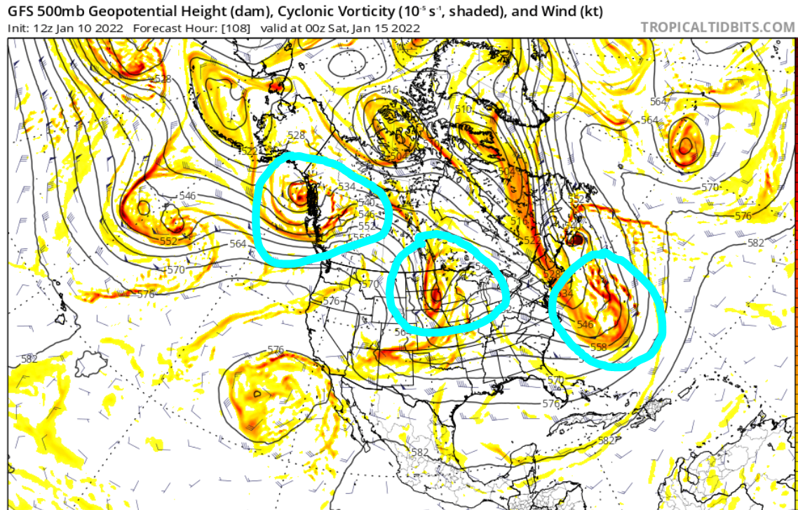
The eastern-most circle is a massive Nor'easter that is forecasted to become a sub 970mb storm that hits the southeast coast of Canada. The southern energy ends up phasing with a piece of the Polar Vortex, and due to blocking in the northern Atlantic, we see this Nor'easter make a left-hook into Canada instead of moving innocently out to sea. As a result, this system may potentially act as our 50-50 Low for the next storm (center circle). However, it can also play spoiler for the next system on the 17th.
Part of the issue with this set-up (16th-17th) is that our heights along the coast are dampened because just 36 hours before then, the Nor'easter traveled north of our latitude which brought the baroclinic zone way to our south and east. Notice how the main storm is well to our south on the latest GFS (closed ULL over south carolina). This gives the Mid-Atlantic areas a nice snowstorm (southern slider).

This ULL needs to be much further north if we want the surface low to bring us a nice moderately-sized snowstorm/clipper. This clipper could then 'blow up' into a significant storm off the coast. There's still plenty of time between now and then for that to happen. The Ensembles show some members reaching our latitude, because either the Nor'easter sped up or the energy behind it slowed down, which created additional spacing between these two systems.
If you refer back to my original map, the western-most circle would be a potential threat near the 18th. Actually, the map below is a better illustration of all 3 of these waves. Notice the 50-50 (a powerful one at that) in SE Canada, the 'southern slider' over South Carolina, and the third potential wave coming down the Rockies out west.

I had mentioned this in an earlier post over the weekend, but if none of these threats end up materializing it's because there's simply too many chefs in the kitchen. To get a storm in our neck of the woods, we need specific events to happen and fall in a specific order. If just one of these events do not happen at a time we need it to, then the whole threat is thrown away. Personally, I think next Monday's wave (the 17th) ends up as a clipper that passes through the Mid-Atlantic and southern portions of our area. I really like the wave on the 18th-19th better. What may end up happening is these threats turn into just one threat, and the issue kind of takes care of itself.
Whatever happens, we're by no means done with winter even if we don't see next week pan out. We're looking at an extended period of colder than normal conditions through all of January. I'm not yet sold on February, but I do think January will deliver at least one solid storm for our area. Let's bring that Godzilla home...
_________________
_______________________________________________________________________________________________________
CLICK HERE to view NJ Strong Snowstorm Classifications

Frank_Wx- Godzilla Seeker

- Posts : 21305
Reputation : 328
Join date : 2013-01-05
Age : 31
Location : Jersey City, NJ -

rb924119 and SENJsnowman like this post
Re: Long Range Discussion 22.0
![]() by Frank_Wx Mon Jan 10, 2022 4:12 pm
by Frank_Wx Mon Jan 10, 2022 4:12 pm
1) Does the Nor'easter over the Atlantic weaken and/or speed up? This would be a favorable trend for the Sunday-Monday threat
2) Will there really be two separate waves of energy behind the Nor'easter, or could we consolidate this into one storm? That would greatly enhance our chances of seeing snow
3) If these streams of energy remain separated, as models currently show, can we get the third wave to hang back a little longer to allow heights over the east coast to normalize? Or else it could end up acting as a 'kicker' for the storm on the 16th-17th
_________________
_______________________________________________________________________________________________________
CLICK HERE to view NJ Strong Snowstorm Classifications
Frank_Wx- Godzilla Seeker
- Posts : 21305
Reputation : 328
Join date : 2013-01-05
Age : 31
Location : Jersey City, NJ -
rb924119 likes this post
Re: Long Range Discussion 22.0
![]() by Frank_Wx Mon Jan 10, 2022 4:52 pm
by Frank_Wx Mon Jan 10, 2022 4:52 pm
rb924119 wrote:As promised, here is the video of my thoughts on the January 16th system. This was a VERY DIFFICULT forecast to come up with, as several of us have alluded to over the last day or so. Not only are there multiple moving parts, but they are also all embedded within a changing global pattern change - part of which is progressive, part of which is regressive. So, with that said, it is highly possible that the thoughts presented herein turn out to be incorrect, BUT, they are what my analysis resulted in.
I hope that you all enjoy it, and that it's fairly easy to understand, but it is a highly complex forecast. Honestly, this is one of the hardest forecasts that I have been involved with in a long time. Therefore, please don't hesitate to ask any questions or comment on something that isn't easily understood. I was a little pressed for time, so I couldn't take several cuts. If it seems a little haphazard as a result, I apologize, but I think it should have been presented at least somewhat logically and thoroughly haha
Anyway, thanks for taking your time to watch, and I look forward to further discussion and tracking!!
https://drive.google.com/file/d/1FPOUBlBym2N23_O71NDpoZ0zzf2Y_kQB/view?usp=sharing
P.S. all data used in this analysis was from today (09th January), and any model data was from the 12z GEFS run from 09th January.
Actually found time after a work meeting to watch this. Very well presented and thought out. Also, for those who have a tough time reading the Hovmoller maps, Ray does an excellent job describing what they show and their importance to the MJO and overall pattern.
We echo the same thoughts with regards to the 16th-17th. Now, if some of the trends I mention above come together, there's a chance we gradually see models come north with this low pressure. Somehow need to get that height response ahead of the ULL. Nice video sir!
_________________
_______________________________________________________________________________________________________
CLICK HERE to view NJ Strong Snowstorm Classifications
Frank_Wx- Godzilla Seeker
- Posts : 21305
Reputation : 328
Join date : 2013-01-05
Age : 31
Location : Jersey City, NJ -
rb924119 and phil155 like this post
Re: Long Range Discussion 22.0
![]() by rb924119 Mon Jan 10, 2022 7:45 pm
by rb924119 Mon Jan 10, 2022 7:45 pm
Also, to maybe quell your fears for February a bit and serve as supporting evidence for my long-term forecast
[url=https://servimg.com/view/19130284/531
 [/url]
rb924119- Meteorologist
- Posts : 6890
Reputation : 194
Join date : 2013-02-06
Age : 32
Location : Greentown, Pa
Frank_Wx likes this post
Re: Long Range Discussion 22.0
![]() by rb924119 Mon Jan 10, 2022 11:37 pm
by rb924119 Mon Jan 10, 2022 11:37 pm
This is why the threat can’t be dismissed yet lol
rb924119- Meteorologist
- Posts : 6890
Reputation : 194
Join date : 2013-02-06
Age : 32
Location : Greentown, Pa

chief7- Posts : 132
Reputation : 0
Join date : 2013-11-10
Location : Langhorne pa
rb924119 likes this post
Re: Long Range Discussion 22.0
![]() by CPcantmeasuresnow Tue Jan 11, 2022 12:17 am
by CPcantmeasuresnow Tue Jan 11, 2022 12:17 am

CPcantmeasuresnow- Wx Statistician Guru
- Posts : 7274
Reputation : 230
Join date : 2013-01-07
Age : 103
Location : Eastern Orange County, NY
rb924119 likes this post
Re: Long Range Discussion 22.0
![]() by Irish Tue Jan 11, 2022 12:43 am
by Irish Tue Jan 11, 2022 12:43 am
rb924119 wrote:NOBODY LOOK AT THE GFS FOR THIS WEEKEND
This is why the threat can’t be dismissed yet lol
How serious can the GooFuS be taken?

Irish- Pro Enthusiast
- Posts : 788
Reputation : 19
Join date : 2019-01-16
Age : 45
Location : Old Bridge, NJ
Re: Long Range Discussion 22.0
![]() by rb924119 Tue Jan 11, 2022 12:56 am
by rb924119 Tue Jan 11, 2022 12:56 am
rb924119- Meteorologist
- Posts : 6890
Reputation : 194
Join date : 2013-02-06
Age : 32
Location : Greentown, Pa
CPcantmeasuresnow, chief7, SENJsnowman, Irish, phil155 and Bwtr like this post
Re: Long Range Discussion 22.0
![]() by CPcantmeasuresnow Tue Jan 11, 2022 12:57 am
by CPcantmeasuresnow Tue Jan 11, 2022 12:57 am
.Irish wrote:rb924119 wrote:NOBODY LOOK AT THE GFS FOR THIS WEEKEND
This is why the threat can’t be dismissed yet lol
How serious can the GooFuS be taken?
It’s on its own right now. The CMC was close tonight but wide tight. The ICON was very wide right. Will see what the Euro does tonight. If it has anything similar maybe we’re onto something.
CPcantmeasuresnow- Wx Statistician Guru
- Posts : 7274
Reputation : 230
Join date : 2013-01-07
Age : 103
Location : Eastern Orange County, NY
rb924119, chief7 and Irish like this post
Re: Long Range Discussion 22.0
![]() by skinsfan1177 Tue Jan 11, 2022 5:27 am
by skinsfan1177 Tue Jan 11, 2022 5:27 am

skinsfan1177- Senior Enthusiast
- Posts : 4485
Reputation : 35
Join date : 2013-01-07
Age : 46
Location : Point Pleasant Boro

skinsfan1177- Senior Enthusiast
- Posts : 4485
Reputation : 35
Join date : 2013-01-07
Age : 46
Location : Point Pleasant Boro
Re: Long Range Discussion 22.0
![]() by heehaw453 Tue Jan 11, 2022 5:51 am
by heehaw453 Tue Jan 11, 2022 5:51 am
06Z showing ridge

18z yesterday showing trough

Last edited by heehaw453 on Tue Jan 11, 2022 6:09 am; edited 1 time in total
heehaw453- Advanced Forecaster
- Posts : 3906
Reputation : 86
Join date : 2014-01-20
Location : Bedminster Township, PA Elevation 600' ASL
Page 25 of 31 • 1 ... 14 ... 24, 25, 26 ... 31 ![]()
|
|
|