
 Search
Long Range Discussion 22.0
Page 26 of 31 •  1 ... 14 ... 25, 26, 27 ... 31
 ![]()

skinsfan1177- Senior Enthusiast

- Posts : 4485
Join date : 2013-01-07
Re: Long Range Discussion 22.0
![]() by heehaw453 Tue Jan 11, 2022 5:51 am
by heehaw453 Tue Jan 11, 2022 5:51 am
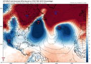
06Z showing ridge

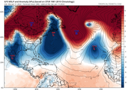
18z yesterday showing trough

Last edited by heehaw453 on Tue Jan 11, 2022 6:09 am; edited 1 time in total
heehaw453- Advanced Forecaster

- Posts : 3906
Join date : 2014-01-20
Re: Long Range Discussion 22.0
![]() by heehaw453 Tue Jan 11, 2022 5:54 am
by heehaw453 Tue Jan 11, 2022 5:54 am
heehaw453- Advanced Forecaster
- Posts : 3906
Reputation : 86
Join date : 2014-01-20
Location : Bedminster Township, PA Elevation 600' ASL
CPcantmeasuresnow likes this post
Re: Long Range Discussion 22.0
![]() by skinsfan1177 Tue Jan 11, 2022 5:57 am
by skinsfan1177 Tue Jan 11, 2022 5:57 am
heehaw453 wrote:The 06Z GFS is so tucked there is warm air aloft on SE NJ.
Imo good to see a western solution

skinsfan1177- Senior Enthusiast
- Posts : 4485
Reputation : 35
Join date : 2013-01-07
Age : 46
Location : Point Pleasant Boro
CPcantmeasuresnow likes this post
Re: Long Range Discussion 22.0
![]() by heehaw453 Tue Jan 11, 2022 6:01 am
by heehaw453 Tue Jan 11, 2022 6:01 am

heehaw453- Advanced Forecaster
- Posts : 3906
Reputation : 86
Join date : 2014-01-20
Location : Bedminster Township, PA Elevation 600' ASL
MattyICE likes this post
Re: Long Range Discussion 22.0
![]() by heehaw453 Tue Jan 11, 2022 6:34 am
by heehaw453 Tue Jan 11, 2022 6:34 am

heehaw453- Advanced Forecaster
- Posts : 3906
Reputation : 86
Join date : 2014-01-20
Location : Bedminster Township, PA Elevation 600' ASL
Re: Long Range Discussion 22.0
![]() by Frank_Wx Tue Jan 11, 2022 7:31 am
by Frank_Wx Tue Jan 11, 2022 7:31 am
you continue through the run doing this comparison you’ll notice the storm ends up further north on the 06z run, and heights along the east coast are able to normalize in time for the possible storm on the 16th.
I wouldn’t get too excited about what the GFS spat out this morning, because it’s own ensembles are in major disagreement. All of the members still slide the storm to our south. We’re also seeing the same from the Canadian and EURO - but I do think those models trended favorably for our area overnight. Plenty of time for positive changes to keep happening!
_________________
_______________________________________________________________________________________________________
CLICK HERE to view NJ Strong Snowstorm Classifications

Frank_Wx- Godzilla Seeker

- Posts : 21305
Reputation : 328
Join date : 2013-01-05
Age : 31
Location : Jersey City, NJ -

Re: Long Range Discussion 22.0
![]() by heehaw453 Tue Jan 11, 2022 7:56 am
by heehaw453 Tue Jan 11, 2022 7:56 am
Just my ramblings here...

heehaw453- Advanced Forecaster
- Posts : 3906
Reputation : 86
Join date : 2014-01-20
Location : Bedminster Township, PA Elevation 600' ASL
SENJsnowman likes this post
Re: Long Range Discussion 22.0
![]() by heehaw453 Tue Jan 11, 2022 8:28 am
by heehaw453 Tue Jan 11, 2022 8:28 am

heehaw453- Advanced Forecaster
- Posts : 3906
Reputation : 86
Join date : 2014-01-20
Location : Bedminster Township, PA Elevation 600' ASL
crippo84 likes this post
Re: Long Range Discussion 22.0
![]() by Snow88 Tue Jan 11, 2022 9:04 am
by Snow88 Tue Jan 11, 2022 9:04 am

Snow88- Senior Enthusiast
- Posts : 2193
Reputation : 4
Join date : 2013-01-09
Age : 35
Location : Brooklyn, NY
Re: Long Range Discussion 22.0
![]() by heehaw453 Tue Jan 11, 2022 9:21 am
by heehaw453 Tue Jan 11, 2022 9:21 am

heehaw453- Advanced Forecaster
- Posts : 3906
Reputation : 86
Join date : 2014-01-20
Location : Bedminster Township, PA Elevation 600' ASL
Re: Long Range Discussion 22.0
![]() by sroc4 Tue Jan 11, 2022 9:53 am
by sroc4 Tue Jan 11, 2022 9:53 am
_________________
"In weather and in life, there's no winning and losing; there's only winning and learning."
WINTER 2012/2013 TOTALS 43.65"WINTER 2017/2018 TOTALS 62.85" WINTER 2022/2023 TOTALS 4.9"
WINTER 2013/2014 TOTALS 64.85"WINTER 2018/2019 TOTALS 14.25" WINTER 2023/2024 TOTALS 13.1"
WINTER 2014/2015 TOTALS 71.20"WINTER 2019/2020 TOTALS 6.35"
WINTER 2015/2016 TOTALS 35.00"WINTER 2020/2021 TOTALS 37.75"
WINTER 2016/2017 TOTALS 42.25"WINTER 2021/2022 TOTALS 31.65"

sroc4- Admin
- Posts : 8331
Reputation : 301
Join date : 2013-01-07
Location : Wading River, LI
Re: Long Range Discussion 22.0
![]() by Frank_Wx Tue Jan 11, 2022 10:20 am
by Frank_Wx Tue Jan 11, 2022 10:20 am
heehaw453 wrote:This is the 06Z Euro Control run. It's very similar look to the 06Z GFS. Much better spacing to the north and heights rise dramatically. 50/50 low to boot. That trailing energy hitting it in the rear NOT before it's negatively tilted. Very delicate but plausible solution.
Madonne…
_________________
_______________________________________________________________________________________________________
CLICK HERE to view NJ Strong Snowstorm Classifications
Frank_Wx- Godzilla Seeker
- Posts : 21305
Reputation : 328
Join date : 2013-01-05
Age : 31
Location : Jersey City, NJ -
heehaw453 and Irish like this post
Re: Long Range Discussion 22.0
![]() by Frank_Wx Tue Jan 11, 2022 10:21 am
by Frank_Wx Tue Jan 11, 2022 10:21 am
sroc4 wrote:Def dont sleep on Sat yet either. NAM is actually pretty close for eastern members at 500mb. 6-8 hrs difference to the timing of either N or S piece and you may have somethig. LR NAM though so grain of salt for now
Yea, should be mentioned. I don’t like the rolling ridge though.

_________________
_______________________________________________________________________________________________________
CLICK HERE to view NJ Strong Snowstorm Classifications
Frank_Wx- Godzilla Seeker
- Posts : 21305
Reputation : 328
Join date : 2013-01-05
Age : 31
Location : Jersey City, NJ -
Re: Long Range Discussion 22.0
![]() by nutleyblizzard Tue Jan 11, 2022 10:32 am
by nutleyblizzard Tue Jan 11, 2022 10:32 am

ICON way west for Mondays storm.

nutleyblizzard- Senior Enthusiast
- Posts : 1952
Reputation : 41
Join date : 2014-01-30
Age : 58
Location : Nutley, new jersey
CPcantmeasuresnow, dkodgis and Irish like this post
Re: Long Range Discussion 22.0
![]() by heehaw453 Tue Jan 11, 2022 10:43 am
by heehaw453 Tue Jan 11, 2022 10:43 am
nutleyblizzard wrote:
ICON way west for Mondays storm.
And it didn't even come close to a phase. That was purely better spacing to the north. Good TRENDS!
heehaw453- Advanced Forecaster
- Posts : 3906
Reputation : 86
Join date : 2014-01-20
Location : Bedminster Township, PA Elevation 600' ASL
Re: Long Range Discussion 22.0
![]() by heehaw453 Tue Jan 11, 2022 11:22 am
by heehaw453 Tue Jan 11, 2022 11:22 am
heehaw453- Advanced Forecaster
- Posts : 3906
Reputation : 86
Join date : 2014-01-20
Location : Bedminster Township, PA Elevation 600' ASL
Re: Long Range Discussion 22.0
![]() by nutleyblizzard Tue Jan 11, 2022 11:27 am
by nutleyblizzard Tue Jan 11, 2022 11:27 am
With that depiction we need to have the trough a bit further east or there will be some serious mixing issues. It’s all fodder at this point since we’re 5+ days away from the event. One things for sure if this storm lives to its full potential it would be a real powerhouse.heehaw453 wrote:12Z GFS is a fully phased beast hugging coast. I want to see ensembles start aligning though.
nutleyblizzard- Senior Enthusiast
- Posts : 1952
Reputation : 41
Join date : 2014-01-30
Age : 58
Location : Nutley, new jersey
Re: Long Range Discussion 22.0
![]() by CPcantmeasuresnow Tue Jan 11, 2022 11:28 am
by CPcantmeasuresnow Tue Jan 11, 2022 11:28 am
heehaw453 wrote:12Z GFS is a fully phased beast hugging coast. I want to see ensembles start aligning though.
That's three runs in a row the operational is showing 12+ for at least the north and west part of the forum. Interesting trends for sure. I'll leave the details to you and the experts.

CPcantmeasuresnow- Wx Statistician Guru

- Posts : 7274
Reputation : 230
Join date : 2013-01-07
Age : 103
Location : Eastern Orange County, NY
dkodgis likes this post
rb924119- Meteorologist

- Posts : 6890
Reputation : 194
Join date : 2013-02-06
Age : 32
Location : Greentown, Pa
dkodgis likes this post
Re: Long Range Discussion 22.0
![]() by Frank_Wx Tue Jan 11, 2022 11:34 am
by Frank_Wx Tue Jan 11, 2022 11:34 am
_________________
_______________________________________________________________________________________________________
CLICK HERE to view NJ Strong Snowstorm Classifications
Frank_Wx- Godzilla Seeker
- Posts : 21305
Reputation : 328
Join date : 2013-01-05
Age : 31
Location : Jersey City, NJ -
Irish likes this post
Re: Long Range Discussion 22.0
![]() by Frank_Wx Tue Jan 11, 2022 12:06 pm
by Frank_Wx Tue Jan 11, 2022 12:06 pm
_________________
_______________________________________________________________________________________________________
CLICK HERE to view NJ Strong Snowstorm Classifications
Frank_Wx- Godzilla Seeker
- Posts : 21305
Reputation : 328
Join date : 2013-01-05
Age : 31
Location : Jersey City, NJ -
CPcantmeasuresnow, rb924119, crippo84, brownie, dkodgis, SENJsnowman, Irish and phil155 like this post
Re: Long Range Discussion 22.0
![]() by heehaw453 Tue Jan 11, 2022 12:08 pm
by heehaw453 Tue Jan 11, 2022 12:08 pm
+1Frank_Wx wrote:The GFS/GEFS show an endless run of cold and multiple snow threats. It's a winter weenie paradise starting this weekend all the way into February. Kudos Ray on recognizing this pattern.
heehaw453- Advanced Forecaster
- Posts : 3906
Reputation : 86
Join date : 2014-01-20
Location : Bedminster Township, PA Elevation 600' ASL
CPcantmeasuresnow and rb924119 like this post
Re: Long Range Discussion 22.0
![]() by amugs Tue Jan 11, 2022 1:11 pm
by amugs Tue Jan 11, 2022 1:11 pm
amugs wrote:You guys are using OP 500mb maps a week out in this most volatile pattern with HUGE changes between the MJO in Phase 8, SOI crash, a cut off low in the Baja of Cali = Split Flow and STJ injection happening not to mention a NAO going Negative, EPO and PNA flipping with a PV entering the picture?
ENS peeps are teh way to go. In no way can one say this is a miss at the 15-17th time frame at this stage with all the aforementioned IMO.
Time will tell. GEFS and EURO ENS are showing some very good LP positions and indicy members. Just like Friday's storm models are going o struggle mightily until we are in a few days.
Time will tell but the Massive Ocean storm has a huge role in the follow up system. If that system doesn't exit quick enough than we may very miss the 15-17th but if it does than the follow up storm can come N.
Bump that's all.
EPO on EURO is insanely Negative - this would rival the 93-94 January MLK week cold outbreak

Saturday and Sunday are colder than today - the Arctic air comes N NW not NW which allowed the Great Lakes to help modify the air a bit than modeled a few days ago.
This is exactly what we want to see for a sustained cold adn stormy pattern
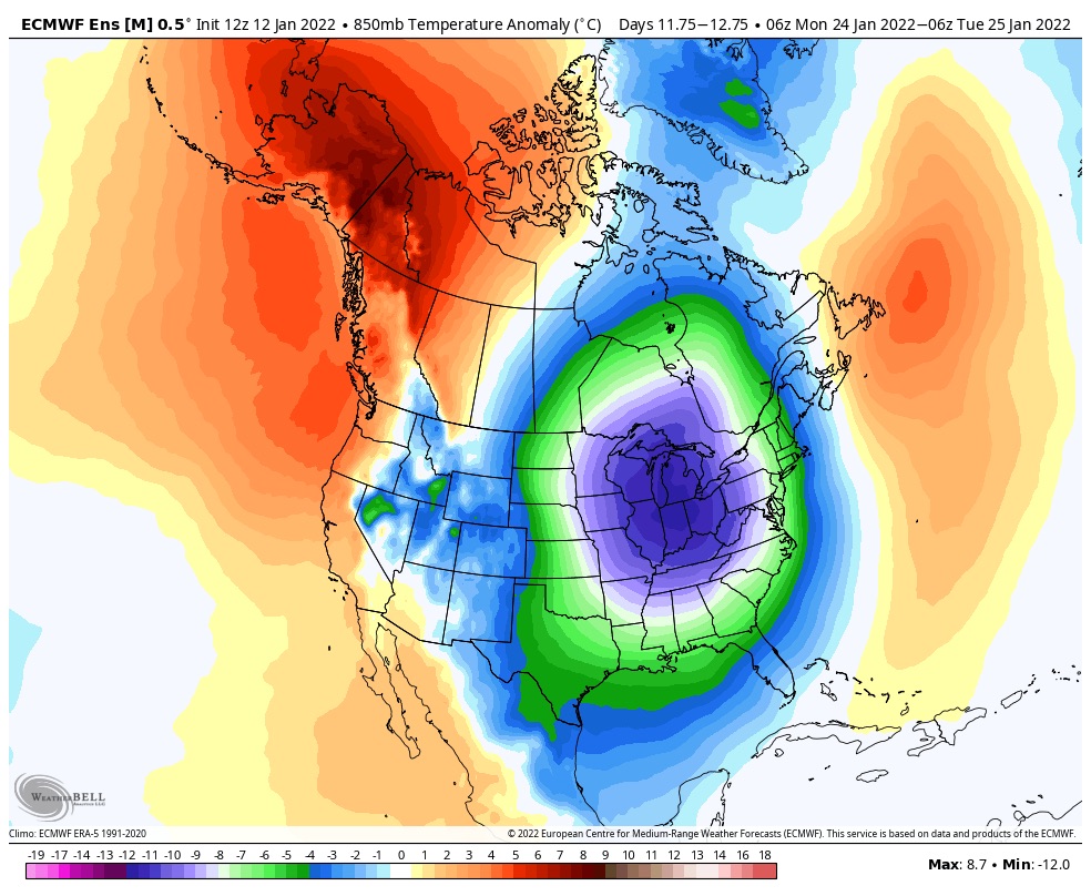
GEFS is locked into a well-oiled machine at the moment. Low in Scandi/Barents, High in E Asia, Low in the Aleutians, Highs dropping down E of the Rockies. It's quite a sight pic.twitter.com/qrS3Q0ThPa
— griteater (@griteater) January 11, 2022
Stretch it real good!! You may say well the PV is very strong and yes very looking at Zonal wind charts BUT we an elongation that has taken place and looks to be sustained through the end of the month and maybe beyond as a result of teh MJO phase 6 adn the +EAMT along with the SCAN HP through the last 2.5 week of December.
"Once, twice, three times a stretched PV" This morning's GFS suggestive of two more stretched polar vortex events for the hattrick this month. This would likely persist #cold & possibly #snowy pattern across eastern North America. Confident about the first, second is speculative. pic.twitter.com/AF98FBHVYl
— Judah Cohen (@judah47) January 11, 2022
Buckle up peeps we are gonna be tracking for a nice period of time. Don't fret if every storm isn't a bomb etc and please have patience to the pattern and not live n die by every OP run. Recognize the pattern is conducive for opportunities and as I said in my rant above - this is a volatile pattern and even the ENS will struggle to pick up on things BUT we can see Friday storm guidance dance with some of these storms. Ala 14-15 and 17-18 IMO.
The Aleutian Low recycling is very important to blocking the Pac Jet and its retraction as is the Siberian and Korean Peninsula Systems. This will allow teh EPO to stay and PNA to rise.
_________________
Mugs
AKA:King: Snow Weenie
Self Proclaimed
WINTER 2014-15 : 55.12" +.02 for 6 coatings (avg. 35")
WINTER 2015-16 Total - 29.8" (Avg 35")
WINTER 2016-17 : 39.5" so far

amugs- Advanced Forecaster - Mod

- Posts : 15093
Reputation : 213
Join date : 2013-01-07
Age : 54
Location : Hillsdale,NJ
kalleg and rb924119 like this post
Re: Long Range Discussion 22.0
![]() by amugs Wed Jan 12, 2022 3:01 pm
by amugs Wed Jan 12, 2022 3:01 pm

_________________
Mugs
AKA:King: Snow Weenie
Self Proclaimed
WINTER 2014-15 : 55.12" +.02 for 6 coatings (avg. 35")
WINTER 2015-16 Total - 29.8" (Avg 35")
WINTER 2016-17 : 39.5" so far
amugs- Advanced Forecaster - Mod
- Posts : 15093
Reputation : 213
Join date : 2013-01-07
Age : 54
Location : Hillsdale,NJ
Re: Long Range Discussion 22.0
![]() by amugs Wed Jan 12, 2022 3:16 pm
by amugs Wed Jan 12, 2022 3:16 pm
_________________
Mugs
AKA:King: Snow Weenie
Self Proclaimed
WINTER 2014-15 : 55.12" +.02 for 6 coatings (avg. 35")
WINTER 2015-16 Total - 29.8" (Avg 35")
WINTER 2016-17 : 39.5" so far
amugs- Advanced Forecaster - Mod
- Posts : 15093
Reputation : 213
Join date : 2013-01-07
Age : 54
Location : Hillsdale,NJ
Re: Long Range Discussion 22.0
![]() by Frank_Wx Wed Jan 12, 2022 4:29 pm
by Frank_Wx Wed Jan 12, 2022 4:29 pm
_________________
_______________________________________________________________________________________________________
CLICK HERE to view NJ Strong Snowstorm Classifications
Frank_Wx- Godzilla Seeker
- Posts : 21305
Reputation : 328
Join date : 2013-01-05
Age : 31
Location : Jersey City, NJ -
phil155 likes this post
Page 26 of 31 • 1 ... 14 ... 25, 26, 27 ... 31 ![]()
|
|
|