
 Search
Long Range Discussion 22.0
Page 28 of 31 •  1 ... 15 ... 27, 28, 29, 30, 31
 ![]()
Re: Long Range Discussion 22.0
![]() by jmanley32 Sun Jan 16, 2022 7:18 am
by jmanley32 Sun Jan 16, 2022 7:18 am
wow that deayh band right over my house, ill take 1 for me plz. Not getting sucking in though, thursday.nutleyblizzard wrote:
Aha there it is. Taken verbatim with 1.5 QPF with temps in the teens during the event it’s a 2 footer. CMC shows a huge hit as well. GFS shows a very strong storm although OTS. The difference with next weekends potential compared to tomorrows rainstorm is that we have a high in the right spot this time. Currently the models see the Day 6 potential then lose it only to bring it back again. Plenty of time to track, but after last nights Euro and CMC runs I’m sure Frank will have a more detailed discussion on it.

jmanley32- Senior Enthusiast

- Posts : 20517
Join date : 2013-12-12
Re: Long Range Discussion 22.0
![]() by SENJsnowman Sun Jan 16, 2022 7:45 am
by SENJsnowman Sun Jan 16, 2022 7:45 am
jmanley32 wrote:wow that deayh band right over my house, ill take 1 for me plz. Not getting sucking in though, thursday.nutleyblizzard wrote:
Aha there it is. Taken verbatim with 1.5 QPF with temps in the teens during the event it’s a 2 footer. CMC shows a huge hit as well. GFS shows a very strong storm although OTS. The difference with next weekends potential compared to tomorrows rainstorm is that we have a high in the right spot this time. Currently the models see the Day 6 potential then lose it only to bring it back again. Plenty of time to track, but after last nights Euro and CMC runs I’m sure Frank will have a more detailed discussion on it.
Good call Jon! As for myself, I’ll be getting sucked in. Probably in the next 24 hours, if the signal persists…
SENJsnowman- Senior Enthusiast
- Posts : 1186
Join date : 2017-01-06
Re: Long Range Discussion 22.0
![]() by heehaw453 Sun Jan 16, 2022 7:55 am
by heehaw453 Sun Jan 16, 2022 7:55 am

heehaw453- Advanced Forecaster

- Posts : 3906
Reputation : 86
Join date : 2014-01-20
Location : Bedminster Township, PA Elevation 600' ASL
CPcantmeasuresnow likes this post
Re: Long Range Discussion 22.0
![]() by jmanley32 Sun Jan 16, 2022 8:43 am
by jmanley32 Sun Jan 16, 2022 8:43 am
Who am I kidding, I will probably get sucked in if theres ALL good signs, if I hear this is a thread the needle not getting my hopes up. Plus got a very busy week, won't be staying up for late night model runs and very little time during day that I can look at models or forum but ill def try.SENJsnowman wrote:jmanley32 wrote:wow that deayh band right over my house, ill take 1 for me plz. Not getting sucking in though, thursday.nutleyblizzard wrote:
Aha there it is. Taken verbatim with 1.5 QPF with temps in the teens during the event it’s a 2 footer. CMC shows a huge hit as well. GFS shows a very strong storm although OTS. The difference with next weekends potential compared to tomorrows rainstorm is that we have a high in the right spot this time. Currently the models see the Day 6 potential then lose it only to bring it back again. Plenty of time to track, but after last nights Euro and CMC runs I’m sure Frank will have a more detailed discussion on it.
Good call Jon! As for myself, I’ll be getting sucked in. Probably in the next 24 hours, if the signal persists…

jmanley32- Senior Enthusiast
- Posts : 20517
Reputation : 108
Join date : 2013-12-12
Age : 42
Location : Yonkers, NY
Re: Long Range Discussion 22.0
![]() by amugs Sun Jan 16, 2022 9:30 am
by amugs Sun Jan 16, 2022 9:30 am
Brooklyn 33 Rain

Can we hold the banana or will it go....banana's!!

_________________
Mugs
AKA:King: Snow Weenie
Self Proclaimed
WINTER 2014-15 : 55.12" +.02 for 6 coatings (avg. 35")
WINTER 2015-16 Total - 29.8" (Avg 35")
WINTER 2016-17 : 39.5" so far

amugs- Advanced Forecaster - Mod

- Posts : 15093
Reputation : 213
Join date : 2013-01-07
Age : 54
Location : Hillsdale,NJ
Re: Long Range Discussion 22.0
![]() by Irish Sun Jan 16, 2022 10:13 am
by Irish Sun Jan 16, 2022 10:13 am
Gotta love long range looks. 40% chance of snow showers but getting 3-5 inches, lol. Tells ya something's there but not quite sure at this range.

Irish- Pro Enthusiast

- Posts : 788
Reputation : 19
Join date : 2019-01-16
Age : 45
Location : Old Bridge, NJ
Re: Long Range Discussion 22.0
![]() by amugs Sun Jan 16, 2022 10:59 am
by amugs Sun Jan 16, 2022 10:59 am
Irish wrote:TWC forecast for the 22nd - Snow showers. High 27F. Winds N at 10 to 15 mph. Chance of snow 40%. 3 to 5 inches of snow expected.
Gotta love long range looks. 40% chance of snow showers but getting 3-5 inches, lol. Tells ya something's there but not quite sure at this range.
TWC is the KOD - please ignore and don't post them LOL!
_________________
Mugs
AKA:King: Snow Weenie
Self Proclaimed
WINTER 2014-15 : 55.12" +.02 for 6 coatings (avg. 35")
WINTER 2015-16 Total - 29.8" (Avg 35")
WINTER 2016-17 : 39.5" so far
amugs- Advanced Forecaster - Mod
- Posts : 15093
Reputation : 213
Join date : 2013-01-07
Age : 54
Location : Hillsdale,NJ
CPcantmeasuresnow, jmanley32 and Irish like this post
Re: Long Range Discussion 22.0
![]() by jmanley32 Sun Jan 16, 2022 11:02 am
by jmanley32 Sun Jan 16, 2022 11:02 am
Yup do not know why people even waste their time looking. All they do is fake sensationalization stuff, i liked it back when there was john hope and Cantore was a somewhat normal weather man. The only time I will look at it is to see live footage from places storms are going on they do take good footage.amugs wrote:Irish wrote:TWC forecast for the 22nd - Snow showers. High 27F. Winds N at 10 to 15 mph. Chance of snow 40%. 3 to 5 inches of snow expected.
Gotta love long range looks. 40% chance of snow showers but getting 3-5 inches, lol. Tells ya something's there but not quite sure at this range.
TWC is the KOD - please ignore and don't post them LOL!
jmanley32- Senior Enthusiast
- Posts : 20517
Reputation : 108
Join date : 2013-12-12
Age : 42
Location : Yonkers, NY
Re: Long Range Discussion 22.0
![]() by Irish Sun Jan 16, 2022 11:16 am
by Irish Sun Jan 16, 2022 11:16 am
jmanley32 wrote:Yup do not know why people even waste their time looking. All they do is fake sensationalization stuff, i liked it back when there was john hope and Cantore was a somewhat normal weather man. The only time I will look at it is to see live footage from places storms are going on they do take good footage.amugs wrote:Irish wrote:TWC forecast for the 22nd - Snow showers. High 27F. Winds N at 10 to 15 mph. Chance of snow 40%. 3 to 5 inches of snow expected.
Gotta love long range looks. 40% chance of snow showers but getting 3-5 inches, lol. Tells ya something's there but not quite sure at this range.
TWC is the KOD - please ignore and don't post them LOL!
I've wasted my time on there because before I stumbled onto this place, I was an ignorant weather watcher and TWC is all I had. Now I know better and just use them for laughs.
Irish- Pro Enthusiast
- Posts : 788
Reputation : 19
Join date : 2019-01-16
Age : 45
Location : Old Bridge, NJ
sroc4, amugs, CPcantmeasuresnow, kalleg, dkodgis and Sparky Sparticles like this post
Re: Long Range Discussion 22.0
![]() by CPcantmeasuresnow Sun Jan 16, 2022 12:54 pm
by CPcantmeasuresnow Sun Jan 16, 2022 12:54 pm
Irish wrote:TWC forecast for the 22nd - Snow showers. High 27F. Winds N at 10 to 15 mph. Chance of snow 40%. 3 to 5 inches of snow expected.
Gotta love long range looks. 40% chance of snow showers but getting 3-5 inches, lol. Tells ya something's there but not quite sure at this range.
TWC had me for 10-17 inches for tonight and Mondays storm 5-6 days ago.
If I net 4 inches OTG when it's all said and done tomorrow I'll consider it a win.

CPcantmeasuresnow- Wx Statistician Guru

- Posts : 7274
Reputation : 230
Join date : 2013-01-07
Age : 103
Location : Eastern Orange County, NY
Re: Long Range Discussion 22.0
![]() by MattyICE Sun Jan 16, 2022 2:57 pm
by MattyICE Sun Jan 16, 2022 2:57 pm
MattyICE- Advanced Forecaster
- Posts : 249
Reputation : 6
Join date : 2017-11-10
Age : 38
Location : Clifton, NJ (Eastern Passaic County)
Re: Long Range Discussion 22.0
![]() by lglickman1 Sun Jan 16, 2022 5:43 pm
by lglickman1 Sun Jan 16, 2022 5:43 pm
lglickman1- Pro Enthusiast
- Posts : 319
Reputation : 0
Join date : 2013-02-05
Location : New Rochelle, NY
Re: Long Range Discussion 22.0
![]() by Frank_Wx Sun Jan 16, 2022 7:31 pm
by Frank_Wx Sun Jan 16, 2022 7:31 pm
lglickman1 wrote:Is this a reasonable setup for the 22nd-23rd? Or something not likely to come together?
I think the setup on the 23rd is plausible and could deliver a nice snowfall for our area, but I’m particularly interested in the 25th-28th which I’m now extending out to the 1st of February. I’m going to give these waves a deeper look tomorrow
_________________
_______________________________________________________________________________________________________
CLICK HERE to view NJ Strong Snowstorm Classifications

Frank_Wx- Godzilla Seeker

- Posts : 21305
Reputation : 328
Join date : 2013-01-05
Age : 31
Location : Jersey City, NJ -

jmanley32, heehaw453 and weatherwatchermom like this post
Re: Long Range Discussion 22.0
![]() by jmanley32 Sun Jan 16, 2022 10:04 pm
by jmanley32 Sun Jan 16, 2022 10:04 pm
jmanley32- Senior Enthusiast
- Posts : 20517
Reputation : 108
Join date : 2013-12-12
Age : 42
Location : Yonkers, NY
Re: Long Range Discussion 22.0
![]() by heehaw453 Mon Jan 17, 2022 9:02 am
by heehaw453 Mon Jan 17, 2022 9:02 am
If we can get a strong WAR then trough can dig more and EC heights can rise easier...
Euro is most aggressive ATTM

heehaw453- Advanced Forecaster
- Posts : 3906
Reputation : 86
Join date : 2014-01-20
Location : Bedminster Township, PA Elevation 600' ASL
Re: Long Range Discussion 22.0
![]() by Frank_Wx Mon Jan 17, 2022 10:43 am
by Frank_Wx Mon Jan 17, 2022 10:43 am
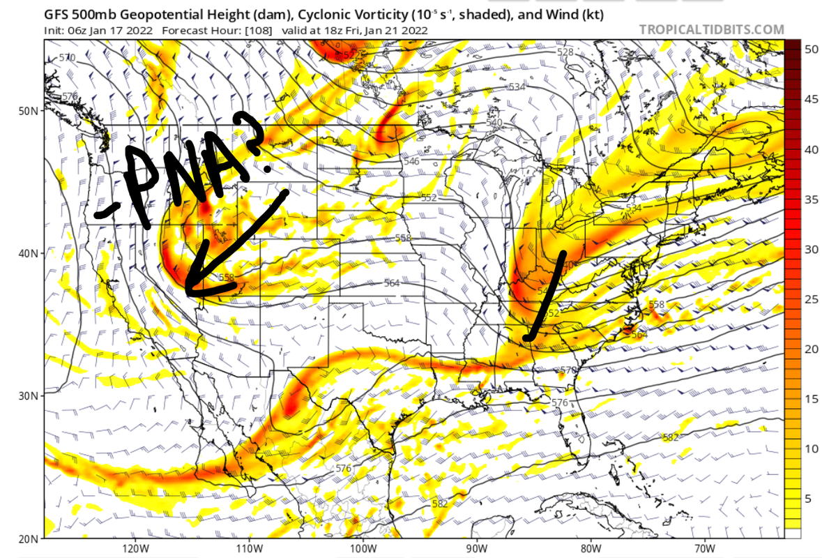
January 23rd:
This one had the appearance of a potentially big system, but over the last 48 hours we have seen this threat fizzle just a little bit. Below is a look at the GFS upper air map valid for Friday the 21st. You can clearly see a trough and associated energy entering the eastern CONUS, but the trough is positively tilted and the energy is a little strung out. There's 2 reasons for that:
1. There's a very strong piece of northern energy that is cutting off over the western U.S., which is bringing the PNA down to negative. This prevents the trough over the east from consolidating the energy at the base and going neutral-negative. There's also another piece of energy over Texas that is being held back. So, we have all this upper energy being held back over western areas of the U.S. which means there's no opportunity for our northern energy to phase.
2. I did not denote it on the map, but if you look in south-central Canada near the Great Lakes we have a ridge rolling east which is also acting to disrupt the trough over the east. That's because just N&W of there we have even more pieces of upper energy coming out of the Pacific. At this time, the AO and NAO are also positive.
The end result is a strung out mess of energy over the east coast, and a surface low positioned well off the coast. So, I am not very enthused about this threat unless we can get the southern short waves over SW CONUS to eject east instead of getting held back. If that happens, and we end up seeing a phase, it could capture the trough and help bring a low up the coast. There's still time for these trends to occur. Let's see what happens over the next 2-3 days.
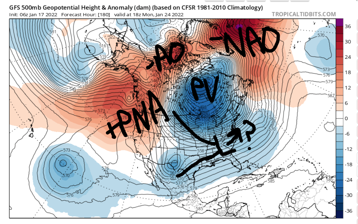
January 25th-27th:
I've mentioned it earlier, but this is the time period I am favoring over the 23rd at this time. By this point, we are seeing some very interesting developments at 500mb.
1). -AO and -NAO return
2). -EPO/+PNA are emerging
3). PV is centered over the Hudson Bay
Remember that ULL I circled in the other graphic in relation to the 23rd storm? Well by the time we get to the 25th, it finally moves out of the southwest U.S. and follows the jet east-northeast. Because of the aforementioned changes aloft, there's a very good chance this southern energy meets up with northern energy to create our next storm. I won't elaborate more beyond this point, but I really do like the upper level picture. Assuming these features do not change (i.e. NAO does not trend back to positive, etc.) then I am excited about a storm.
_________________
_______________________________________________________________________________________________________
CLICK HERE to view NJ Strong Snowstorm Classifications
Frank_Wx- Godzilla Seeker
- Posts : 21305
Reputation : 328
Join date : 2013-01-05
Age : 31
Location : Jersey City, NJ -
Re: Long Range Discussion 22.0
![]() by heehaw453 Mon Jan 17, 2022 11:25 am
by heehaw453 Mon Jan 17, 2022 11:25 am

heehaw453- Advanced Forecaster
- Posts : 3906
Reputation : 86
Join date : 2014-01-20
Location : Bedminster Township, PA Elevation 600' ASL
Frank_Wx likes this post
Re: Long Range Discussion 22.0
![]() by Frank_Wx Mon Jan 17, 2022 11:31 am
by Frank_Wx Mon Jan 17, 2022 11:31 am

_________________
_______________________________________________________________________________________________________
CLICK HERE to view NJ Strong Snowstorm Classifications
Frank_Wx- Godzilla Seeker
- Posts : 21305
Reputation : 328
Join date : 2013-01-05
Age : 31
Location : Jersey City, NJ -
Re: Long Range Discussion 22.0
![]() by amugs Mon Jan 17, 2022 11:58 am
by amugs Mon Jan 17, 2022 11:58 am
This mornings EPS continue a gradual trend of amplifying the mid level disturbance over the Ohio Valley this weekend. If this trend were to continue, we'd likely see the return of model solutions depicting a substantial coastal storm and winter weather threat in the Eastern US. pic.twitter.com/cfn0Bx7iqq
— John Homenuk (@jhomenuk) January 17, 2022
We are seeing what could be and JH doesn't go this route unless he sees the potential at a medium confidence aka like Frank
_________________
Mugs
AKA:King: Snow Weenie
Self Proclaimed
WINTER 2014-15 : 55.12" +.02 for 6 coatings (avg. 35")
WINTER 2015-16 Total - 29.8" (Avg 35")
WINTER 2016-17 : 39.5" so far
amugs- Advanced Forecaster - Mod
- Posts : 15093
Reputation : 213
Join date : 2013-01-07
Age : 54
Location : Hillsdale,NJ
Re: Long Range Discussion 22.0
![]() by amugs Mon Jan 17, 2022 1:33 pm
by amugs Mon Jan 17, 2022 1:33 pm

_________________
Mugs
AKA:King: Snow Weenie
Self Proclaimed
WINTER 2014-15 : 55.12" +.02 for 6 coatings (avg. 35")
WINTER 2015-16 Total - 29.8" (Avg 35")
WINTER 2016-17 : 39.5" so far
amugs- Advanced Forecaster - Mod
- Posts : 15093
Reputation : 213
Join date : 2013-01-07
Age : 54
Location : Hillsdale,NJ
Re: Long Range Discussion 22.0
![]() by heehaw453 Mon Jan 17, 2022 1:33 pm
by heehaw453 Mon Jan 17, 2022 1:33 pm

heehaw453- Advanced Forecaster
- Posts : 3906
Reputation : 86
Join date : 2014-01-20
Location : Bedminster Township, PA Elevation 600' ASL
amugs likes this post
Re: Long Range Discussion 22.0
![]() by heehaw453 Mon Jan 17, 2022 1:40 pm
by heehaw453 Mon Jan 17, 2022 1:40 pm
heehaw453- Advanced Forecaster
- Posts : 3906
Reputation : 86
Join date : 2014-01-20
Location : Bedminster Township, PA Elevation 600' ASL
Re: Long Range Discussion 22.0
![]() by amugs Mon Jan 17, 2022 1:41 pm
by amugs Mon Jan 17, 2022 1:41 pm

_________________
Mugs
AKA:King: Snow Weenie
Self Proclaimed
WINTER 2014-15 : 55.12" +.02 for 6 coatings (avg. 35")
WINTER 2015-16 Total - 29.8" (Avg 35")
WINTER 2016-17 : 39.5" so far
amugs- Advanced Forecaster - Mod
- Posts : 15093
Reputation : 213
Join date : 2013-01-07
Age : 54
Location : Hillsdale,NJ
Re: Long Range Discussion 22.0
![]() by Frank_Wx Mon Jan 17, 2022 2:27 pm
by Frank_Wx Mon Jan 17, 2022 2:27 pm

_________________
_______________________________________________________________________________________________________
CLICK HERE to view NJ Strong Snowstorm Classifications
Frank_Wx- Godzilla Seeker
- Posts : 21305
Reputation : 328
Join date : 2013-01-05
Age : 31
Location : Jersey City, NJ -
Re: Long Range Discussion 22.0
![]() by Irish Mon Jan 17, 2022 2:35 pm
by Irish Mon Jan 17, 2022 2:35 pm
amugs wrote:Money shot. That is a beautiful 500 mb evolution peeps. This would be a BIGLY storm ....if it happens. Friday into Sat.
And here we go... are we at serious tracking mode yet?
Irish- Pro Enthusiast
- Posts : 788
Reputation : 19
Join date : 2019-01-16
Age : 45
Location : Old Bridge, NJ
Re: Long Range Discussion 22.0
![]() by sroc4 Mon Jan 17, 2022 2:36 pm
by sroc4 Mon Jan 17, 2022 2:36 pm
Frank_Wx wrote:EURO just dropped a Roidzilla over the area this weekend
Many corroborating Ens members as well.
_________________
"In weather and in life, there's no winning and losing; there's only winning and learning."
WINTER 2012/2013 TOTALS 43.65"WINTER 2017/2018 TOTALS 62.85" WINTER 2022/2023 TOTALS 4.9"
WINTER 2013/2014 TOTALS 64.85"WINTER 2018/2019 TOTALS 14.25" WINTER 2023/2024 TOTALS 13.1"
WINTER 2014/2015 TOTALS 71.20"WINTER 2019/2020 TOTALS 6.35"
WINTER 2015/2016 TOTALS 35.00"WINTER 2020/2021 TOTALS 37.75"
WINTER 2016/2017 TOTALS 42.25"WINTER 2021/2022 TOTALS 31.65"

sroc4- Admin
- Posts : 8331
Reputation : 301
Join date : 2013-01-07
Location : Wading River, LI
Re: Long Range Discussion 22.0
![]() by nutleyblizzard Mon Jan 17, 2022 2:39 pm
by nutleyblizzard Mon Jan 17, 2022 2:39 pm
Back in the king Euro days I’d be jacked, but since it’s upgrade the model has been inconsistent. The 12z run peaked my interest and it’s a plausible scenario, but I’m not all in until I see more model support.Frank_Wx wrote:EURO just dropped a Roidzilla over the area this weekend

nutleyblizzard- Senior Enthusiast
- Posts : 1952
Reputation : 41
Join date : 2014-01-30
Age : 58
Location : Nutley, new jersey
hyde345 likes this post
Page 28 of 31 • 1 ... 15 ... 27, 28, 29, 30, 31 ![]()
|
|
|