Long Range Discussion 22.0
+33
skinsfan1177
chief7
WeatherBob
emokid51783
hyde345
jmanley32
dsix85
jaydoy
billg315
lglickman1
CPcantmeasuresnow
Snow88
mmanisca
phil155
weatherwatchermom
Dunnzoo
nutleyblizzard
Radz
Irish
Wheezer
Math23x7
rb924119
SENJsnowman
heehaw453
algae888
aiannone
MattyICE
frank 638
Frank_Wx
docstox12
dkodgis
amugs
sroc4
37 posters
Page 30 of 31
Page 30 of 31 •  1 ... 16 ... 29, 30, 31
 Re: Long Range Discussion 22.0
I rarely post, but read all the time. You guys do a great job breaking down each and every storm threat, and I am very happy I found this forum years ago.
Just wanted to tell all the people here ( which I assume is everyone) not to worry at all about the models for Saturdays storm, because the only model you need to know is I am going away for a week this Thursday, and that in itself guarantees a major snowstorm, so enjoy the storm tracking, and don't sweat it. its a lock. I just hope I get to experience at least 1 blizzard this winter, and deff wont complain if their are many more.
Just wanted to tell all the people here ( which I assume is everyone) not to worry at all about the models for Saturdays storm, because the only model you need to know is I am going away for a week this Thursday, and that in itself guarantees a major snowstorm, so enjoy the storm tracking, and don't sweat it. its a lock. I just hope I get to experience at least 1 blizzard this winter, and deff wont complain if their are many more.
dolphins222- Posts : 26
Join date : 2013-10-04
sroc4, amugs, CPcantmeasuresnow, Dunnzoo, brownie, weatherwatchermom and Bwtr like this post
 Re: Long Range Discussion 22.0
Hello gang
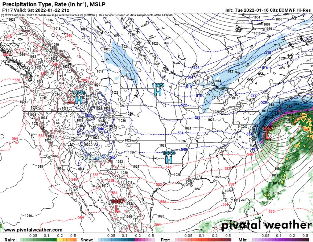
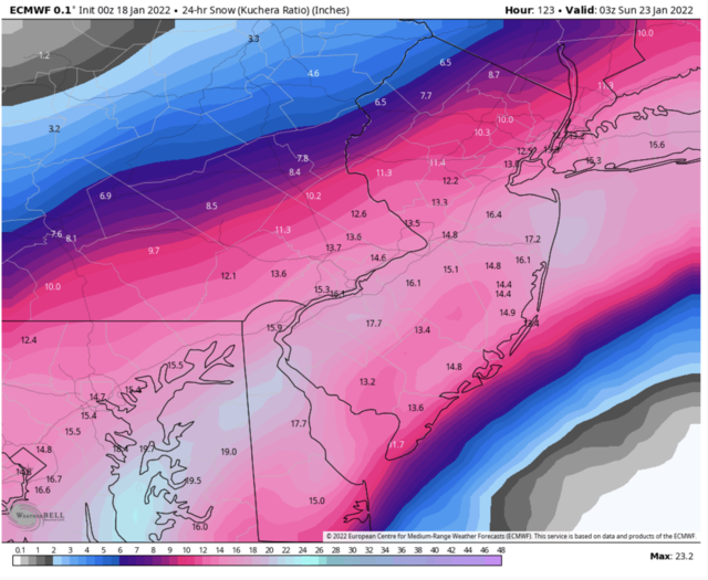
I have been insane busy. Trying to catch up as much as possible, looks like something interesting for this weekend.
We track.
I have been insane busy. Trying to catch up as much as possible, looks like something interesting for this weekend.
We track.
Joe Snow- Pro Enthusiast

- Posts : 933
Join date : 2014-02-12
sroc4, amugs and weatherwatchermom like this post
 Re: Long Range Discussion 22.0
Hey so if this storm happens what is the suspected time frame? I plan to be in CT and returning Sat morning, or should I be planning to leave Friday evening or even Friday morning? Last thing I want to do is be driving in a big storm. Again just trying err on cautious side in case it does happen.

jmanley32- Senior Enthusiast

- Posts : 20635
Reputation : 108
Join date : 2013-12-12
Age : 43
Location : Yonkers, NY
 Re: Long Range Discussion 22.0
Looks like Friday PM on latest Euro into Saturday so I guess I would want to leave by Friday morning?

jmanley32- Senior Enthusiast

- Posts : 20635
Reputation : 108
Join date : 2013-12-12
Age : 43
Location : Yonkers, NY
 Re: Long Range Discussion 22.0
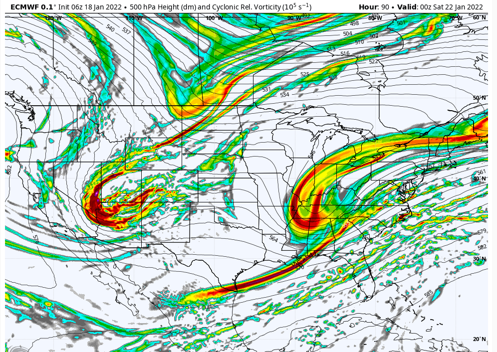
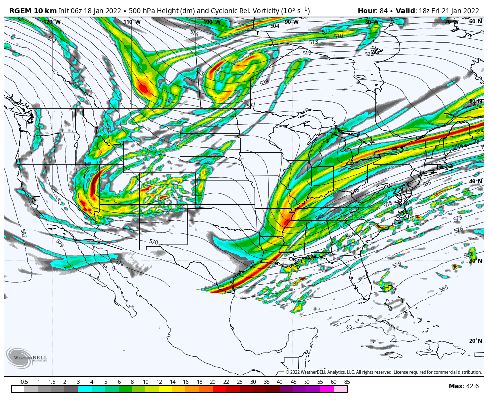
Big difference at h5 compared to 18z
It's not even close
It's not even close

Snow88- Senior Enthusiast

- Posts : 2193
Reputation : 4
Join date : 2013-01-09
Age : 36
Location : Brooklyn, NY
 Re: Long Range Discussion 22.0
jmanley32 wrote:Hey so if this storm happens what is the suspected time frame? I plan to be in CT and returning Sat morning, or should I be planning to leave Friday evening or even Friday morning? Last thing I want to do is be driving in a big storm. Again just trying err on cautious side in case it does happen.
Go Friday
_________________
_______________________________________________________________________________________________________
CLICK HERE to view NJ Strong Snowstorm Classifications
 Re: Long Range Discussion 22.0
Snow88 wrote:Big difference at h5 compared to 18z
It's not even close
Yup, it has trended in the Euros direction over the last several runs. If the GEFS also improve, and the EURO holds tonight, chances of a storm will go up dramatically.
_________________
_______________________________________________________________________________________________________
CLICK HERE to view NJ Strong Snowstorm Classifications
 Re: Long Range Discussion 22.0
00z GEFS now show a partial phase between both streams whereas before they were separated. So, nod to the EURO. Verrry interesting EURO run tonight
_________________
_______________________________________________________________________________________________________
CLICK HERE to view NJ Strong Snowstorm Classifications
 Re: Long Range Discussion 22.0
Doesn't not even close mean not good if we want a storm? Or what way am I supposed to take that? Yeah I am gonna leave early friday morning and be back in time for work. Sounds like this is gaining some ground hopefully.Frank_Wx wrote:Snow88 wrote:Big difference at h5 compared to 18z
It's not even close
Yup, it has trended in the Euros direction over the last several runs. If the GEFS also improve, and the EURO holds tonight, chances of a storm will go up dramatically.

jmanley32- Senior Enthusiast

- Posts : 20635
Reputation : 108
Join date : 2013-12-12
Age : 43
Location : Yonkers, NY
 Re: Long Range Discussion 22.0
OHHH I see, the 00z is much better than 18z meaning the 00z is not even close to 18z in a good direction.

jmanley32- Senior Enthusiast

- Posts : 20635
Reputation : 108
Join date : 2013-12-12
Age : 43
Location : Yonkers, NY
SENJsnowman likes this post

nutleyblizzard- Senior Enthusiast

- Posts : 1963
Reputation : 41
Join date : 2014-01-30
Age : 58
Location : Nutley, new jersey
 Re: Long Range Discussion 22.0
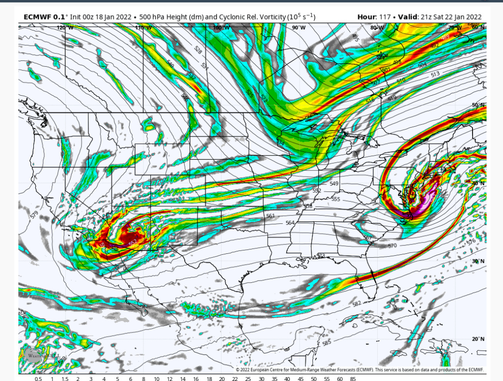
GFS doesn't dig nearly as much on the trough. I think the Euro is digging too much and creating a stronger storm which is delaying the storm's northward progression. Somewhere in the middle maybe closer to reality. In any event there is not unlimited space in the atmosphere. The Euro ULL got kicked off the coast by another system to the west partially because it dug further and was a bit delayed. Again with an active pattern like this there is most likely going to be a faster progression. If I continue to see that idea in future runs this will be a coastal thing threat.

heehaw453- Advanced Forecaster

- Posts : 3907
Reputation : 86
Join date : 2014-01-20
Location : Bedminster Township, PA Elevation 600' ASL
 Re: Long Range Discussion 22.0
As has already been stated GFS took huge strides towards the euro. We now have phasing or at least partial phasing between the northern S/W and the southern piece. Last night I showed how the gfs left the southern energy behind. As of 00z, and again 06z it’s bringing it along. Again it’s a not nearly as strong of a phases as the euro but it doesn’t have to be just yet.
Again nice changes aloft on the gfs towards the euro soln.
Again nice changes aloft on the gfs towards the euro soln.
_________________
"In weather and in life, there's no winning and losing; there's only winning and learning."
WINTER 2012/2013 TOTALS 43.65"WINTER 2017/2018 TOTALS 62.85" WINTER 2022/2023 TOTALS 4.9"
WINTER 2013/2014 TOTALS 64.85"WINTER 2018/2019 TOTALS 14.25" WINTER 2023/2024 TOTALS 13.1"
WINTER 2014/2015 TOTALS 71.20"WINTER 2019/2020 TOTALS 6.35"
WINTER 2015/2016 TOTALS 35.00"WINTER 2020/2021 TOTALS 37.75"
WINTER 2016/2017 TOTALS 42.25"WINTER 2021/2022 TOTALS 31.65"

sroc4- Admin

- Posts : 8441
Reputation : 302
Join date : 2013-01-07
Location : Wading River, LI
 Re: Long Range Discussion 22.0
_________________
_______________________________________________________________________________________________________
CLICK HERE to view NJ Strong Snowstorm Classifications
heehaw453- Advanced Forecaster

- Posts : 3907
Reputation : 86
Join date : 2014-01-20
Location : Bedminster Township, PA Elevation 600' ASL
 Re: Long Range Discussion 22.0
_________________
"In weather and in life, there's no winning and losing; there's only winning and learning."
WINTER 2012/2013 TOTALS 43.65"WINTER 2017/2018 TOTALS 62.85" WINTER 2022/2023 TOTALS 4.9"
WINTER 2013/2014 TOTALS 64.85"WINTER 2018/2019 TOTALS 14.25" WINTER 2023/2024 TOTALS 13.1"
WINTER 2014/2015 TOTALS 71.20"WINTER 2019/2020 TOTALS 6.35"
WINTER 2015/2016 TOTALS 35.00"WINTER 2020/2021 TOTALS 37.75"
WINTER 2016/2017 TOTALS 42.25"WINTER 2021/2022 TOTALS 31.65"

sroc4- Admin

- Posts : 8441
Reputation : 302
Join date : 2013-01-07
Location : Wading River, LI
 Re: Long Range Discussion 22.0
A bit of a southern lean to this. Are we trending toward more of an ‘equitable’ geographic snowfall distribution this winter?
There are definite signs of it. Of course, NNJ, LHV, and LI are simply better climatory spots for consistent action. But for the Shore and certainly for southern Jersey and the mid-Atlantic, this winter already has been noticeably more active and fun than each of the last 3 winters. And if the weekend storm delivers than it will already be more snowfall then the last 3 winters COMBINED!
Last edited by SENJsnowman on Tue Jan 18, 2022 10:05 am; edited 1 time in total
SENJsnowman- Senior Enthusiast

- Posts : 1195
Reputation : 61
Join date : 2017-01-06
Age : 51
Location : Long Branch, NJ
CPcantmeasuresnow and phil155 like this post
 Re: Long Range Discussion 22.0
Question do you think it’s safe for me to go Long Island on Saturday in the afternoon I have a baby shower to go to I’m not sure if the storm is going to happen or not I know things are always changing
frank 638- Senior Enthusiast

- Posts : 2862
Reputation : 37
Join date : 2016-01-01
Age : 41
Location : bronx ny
 Re: Long Range Discussion 22.0
frank 638 wrote:Question do you think it’s safe for me to go Long Island on Saturday in the afternoon I have a baby shower to go to I’m not sure if the storm is going to happen or not I know things are always changing
Too early to tell just need to stay informed on storm trends
_________________
_______________________________________________________________________________________________________
CLICK HERE to view NJ Strong Snowstorm Classifications

nutleyblizzard- Senior Enthusiast

- Posts : 1963
Reputation : 41
Join date : 2014-01-30
Age : 58
Location : Nutley, new jersey
amugs and SENJsnowman like this post
 Re: Long Range Discussion 22.0
thank u frankFrank_Wx wrote:frank 638 wrote:Question do you think it’s safe for me to go Long Island on Saturday in the afternoon I have a baby shower to go to I’m not sure if the storm is going to happen or not I know things are always changing
Too early to tell just need to stay informed on storm trends
frank 638- Senior Enthusiast

- Posts : 2862
Reputation : 37
Join date : 2016-01-01
Age : 41
Location : bronx ny
phil155 likes this post
 Re: Long Range Discussion 22.0
One thing working in the favor of snow lovers on the coast is this upper level jet streak - assuming that at least some phasing and amplification occurs. This is exactly what you want to see for the expansion of precipitation well away from the surface low center. pic.twitter.com/FnoT2Pagmt
— John Homenuk (@jhomenuk) January 18, 2022
_________________
Mugs
AKA:King: Snow Weenie
Self Proclaimed
WINTER 2014-15 : 55.12" +.02 for 6 coatings (avg. 35")
WINTER 2015-16 Total - 29.8" (Avg 35")
WINTER 2016-17 : 39.5" so far

amugs- Advanced Forecaster - Mod

- Posts : 15130
Reputation : 213
Join date : 2013-01-07
Age : 54
Location : Hillsdale,NJ
 Re: Long Range Discussion 22.0
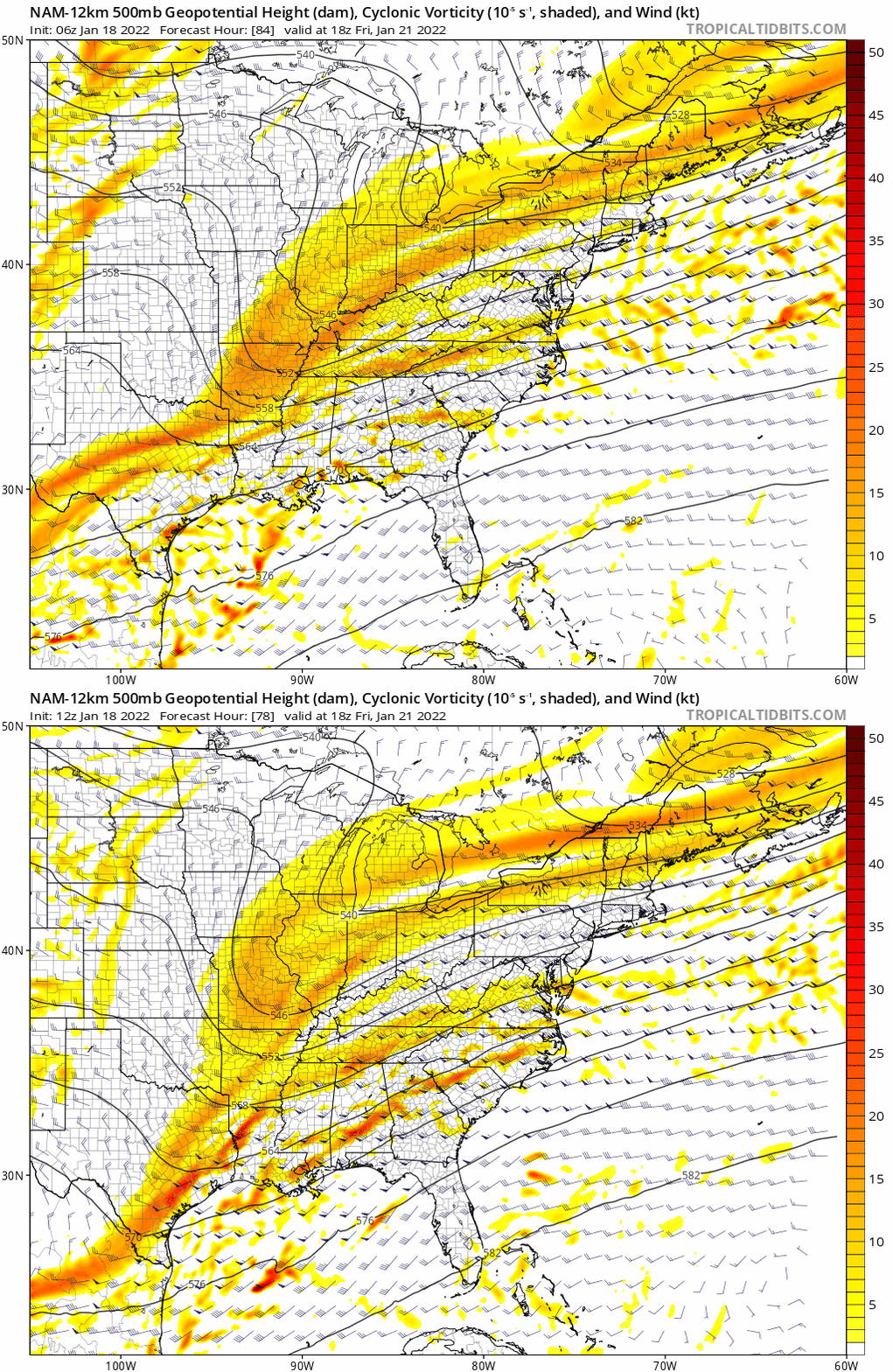
The JET streak can help and aid in th expansion of the precipitation lift and enhance its northward propagation. A stronger jet as being shown on teh EURO and NOW 12Z NAM shows this very nicely.
Thursday's storm have impacts on Saturday is possible - so much energy flying around its quite hard to understand what the models are keying on.

Thursday's storm have impacts on Saturday is possible - so much energy flying around its quite hard to understand what the models are keying on.

_________________
Mugs
AKA:King: Snow Weenie
Self Proclaimed
WINTER 2014-15 : 55.12" +.02 for 6 coatings (avg. 35")
WINTER 2015-16 Total - 29.8" (Avg 35")
WINTER 2016-17 : 39.5" so far

amugs- Advanced Forecaster - Mod

- Posts : 15130
Reputation : 213
Join date : 2013-01-07
Age : 54
Location : Hillsdale,NJ
 Re: Long Range Discussion 22.0
12Z GFS continues to improve on the H5 but it's just not there yet. It has to eject the s/s s/w more and the trough dig a bit more. That interaction is 72 hours out, so I just want to see improvements each run at this point and the 12Z was another step IMO.
heehaw453- Advanced Forecaster

- Posts : 3907
Reputation : 86
Join date : 2014-01-20
Location : Bedminster Township, PA Elevation 600' ASL
SENJsnowman likes this post
heehaw453- Advanced Forecaster

- Posts : 3907
Reputation : 86
Join date : 2014-01-20
Location : Bedminster Township, PA Elevation 600' ASL
 Re: Long Range Discussion 22.0
GFS does depict a coastal storm but not until Sunday which fringes the area.

nutleyblizzard- Senior Enthusiast

- Posts : 1963
Reputation : 41
Join date : 2014-01-30
Age : 58
Location : Nutley, new jersey
 Re: Long Range Discussion 22.0
I know this may be an annoying question, and I know in general in order to get a big costal storm everything has to come together just right, but given the current set up with the atmospheric conditions we have, is a major storm , or even just a moderate impact storm likely, or is the set up unlikely to come together
lglickman1- Pro Enthusiast

- Posts : 319
Reputation : 0
Join date : 2013-02-05
Location : New Rochelle, NY
Page 30 of 31 •  1 ... 16 ... 29, 30, 31
Page 30 of 31
Permissions in this forum:
You cannot reply to topics in this forum|
|
|

 Home
Home