Long Range Discussion 22.0
Page 29 of 31 •  1 ... 16 ... 28, 29, 30, 31
 Re: Long Range Discussion 22.0
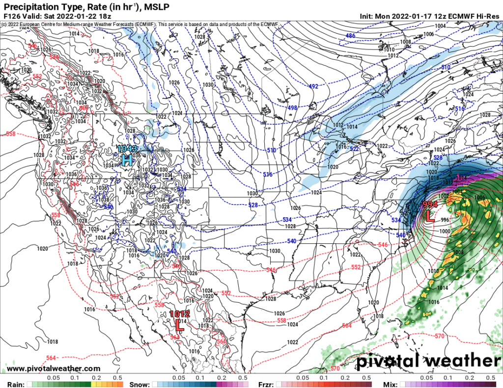
Frank_Wx wrote:EURO just dropped a Roidzilla over the area this weekend

Many corroborating Ens members as well.
sroc4- Admin

- Posts : 8354
Join date : 2013-01-07
 Re: Long Range Discussion 22.0
Back in the king Euro days I’d be jacked, but since it’s upgrade the model has been inconsistent. The 12z run peaked my interest and it’s a plausible scenario, but I’m not all in until I see more model support.Frank_Wx wrote:EURO just dropped a Roidzilla over the area this weekend

nutleyblizzard- Senior Enthusiast

- Posts : 1954
Join date : 2014-01-30
hyde345 likes this post
 Re: Long Range Discussion 22.0
_________________
_______________________________________________________________________________________________________
CLICK HERE to view NJ Strong Snowstorm Classifications
 Re: Long Range Discussion 22.0
Image please of system at least (of course we would love to see clown snow maps...or may be not clow man maps, fingers crossed but def need several runs showing this b4 getting excited? I love it when you post that meme lolFrank_Wx wrote:EURO just dropped a Roidzilla over the area this weekend


jmanley32- Senior Enthusiast

- Posts : 20535
Reputation : 108
Join date : 2013-12-12
Age : 43
Location : Yonkers, NY
 Re: Long Range Discussion 22.0
jmanley32 wrote:Image please of system at least (of course we would love to see clown snow maps...or may be not clow man maps, fingers crossed but def need several runs showing this b4 getting excited? I love it when you post that meme lolFrank_Wx wrote:EURO just dropped a Roidzilla over the area this weekend

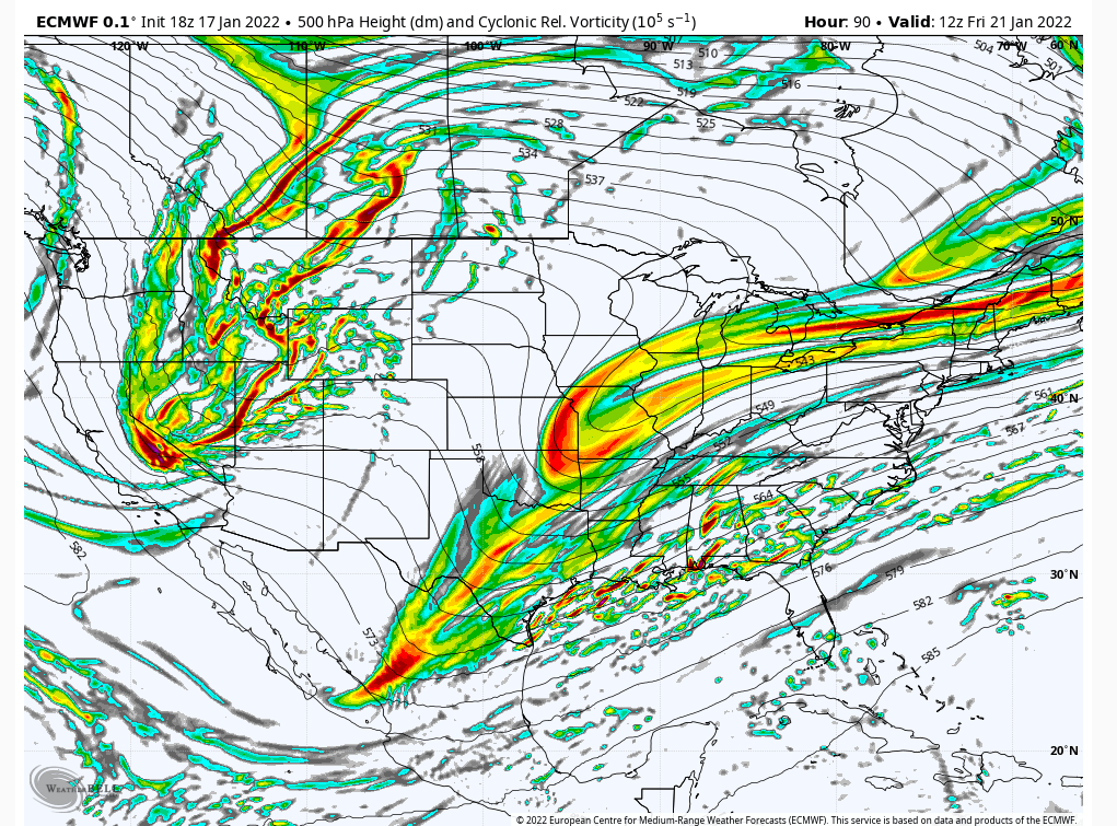
Below is image of Euro storm this weekend. I wouldn't get too excited just yet. A lot of things have to work out for it to happen.

hyde345- Pro Enthusiast

- Posts : 1082
Reputation : 48
Join date : 2013-01-08
Location : Hyde Park, NY
 Re: Long Range Discussion 22.0
Oh I am not get my hopes up yet trust me. But that is beautiful.hyde345 wrote:jmanley32 wrote:Image please of system at least (of course we would love to see clown snow maps...or may be not clow man maps, fingers crossed but def need several runs showing this b4 getting excited? I love it when you post that meme lolFrank_Wx wrote:EURO just dropped a Roidzilla over the area this weekend

Below is image of Euro storm this weekend. I wouldn't get too excited just yet. A lot of things have to work out for it to happen.

jmanley32- Senior Enthusiast

- Posts : 20535
Reputation : 108
Join date : 2013-12-12
Age : 43
Location : Yonkers, NY
 Re: Long Range Discussion 22.0
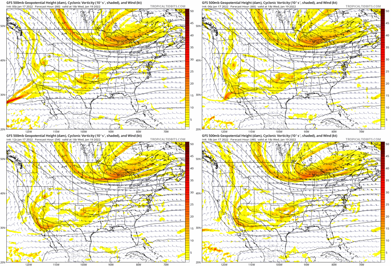
Irish wrote:amugs wrote:Money shot. That is a beautiful 500 mb evolution peeps. This would be a BIGLY storm ....if it happens. Friday into Sat.
And here we go... are we at serious tracking mode yet?
I wouldn't bite on this yet. Need more support from its ensembles and other guidance. But the models at least are dancing to the same song. They just have to start to show they are dancing in sync which right now not there.
heehaw453- Advanced Forecaster

- Posts : 3906
Reputation : 86
Join date : 2014-01-20
Location : Bedminster Township, PA Elevation 600' ASL
Irish likes this post
heehaw453- Advanced Forecaster

- Posts : 3906
Reputation : 86
Join date : 2014-01-20
Location : Bedminster Township, PA Elevation 600' ASL

weatherwatchermom- Senior Enthusiast

- Posts : 3793
Reputation : 78
Join date : 2014-11-25
Location : Hazlet Township, NJ

jmanley32- Senior Enthusiast

- Posts : 20535
Reputation : 108
Join date : 2013-12-12
Age : 43
Location : Yonkers, NY
heehaw453 likes this post
 Re: Long Range Discussion 22.0
_________________
_______________________________________________________________________________________________________
CLICK HERE to view NJ Strong Snowstorm Classifications
Bwtr likes this post
 Re: Long Range Discussion 22.0
Frank_Wx wrote:GFS is still nowehere close with regards to the weekend storm. That said, here's a gif showing the trend last four runs. Notice that southern energy over Baja, which the GFS has been holding back, is trying to move more and more east with consecutive runs. That said, I do not want to discount the GFS being that is forecasted yesterday's storm pretty well in my opinion.
Ryan Maue showed a stat online at 5 days and greater the GFS has been atrocious in the NH. It made some minor improvements at 500 over 12Z but not what the EURO showed for sure. At this stage we track do not discount ANY solutions with the amount of energy flying around. Let's see what Thursday brings which may have an effect on Friday/Saturday system IMO. Time will tell.
_________________
Mugs
AKA:King: Snow Weenie
Self Proclaimed
WINTER 2014-15 : 55.12" +.02 for 6 coatings (avg. 35")
WINTER 2015-16 Total - 29.8" (Avg 35")
WINTER 2016-17 : 39.5" so far

amugs- Advanced Forecaster - Mod

- Posts : 15095
Reputation : 213
Join date : 2013-01-07
Age : 54
Location : Hillsdale,NJ
 Re: Long Range Discussion 22.0

Irish- Pro Enthusiast

- Posts : 788
Reputation : 19
Join date : 2019-01-16
Age : 45
Location : Old Bridge, NJ
amugs likes this post
 Re: Long Range Discussion 22.0
Afternoon GFS now has seven (7) disturbances on the board Friday afternoon lol.
— Jack Sillin (@JackSillin) January 17, 2022
This is medium-range predictability as low as you'll pretty much ever see it in this age of super advanced models pic.twitter.com/kpAJn0Dx4E
_________________
Mugs
AKA:King: Snow Weenie
Self Proclaimed
WINTER 2014-15 : 55.12" +.02 for 6 coatings (avg. 35")
WINTER 2015-16 Total - 29.8" (Avg 35")
WINTER 2016-17 : 39.5" so far

amugs- Advanced Forecaster - Mod

- Posts : 15095
Reputation : 213
Join date : 2013-01-07
Age : 54
Location : Hillsdale,NJ
heehaw453 likes this post
 Re: Long Range Discussion 22.0
heehaw453- Advanced Forecaster

- Posts : 3906
Reputation : 86
Join date : 2014-01-20
Location : Bedminster Township, PA Elevation 600' ASL
 Re: Long Range Discussion 22.0
A Met from another board states that unlike the Euro, the GFS and CMC models often struggle with southern stream energy. They are more reliable with northern stream shortwaves. Something to keep in mind. Could be the GFS is playing catch up. Only time will tell.heehaw453 wrote:It's a question of which s/w the GFS is focusing on. Folks there are a lot of n/s s/w's flying around and I'm not sure the models have agreement onto which one will be the payer. But i can tell you something is cooking for this weekend. It may not come to fruition, but something is cooking. The subtropical jet is active and that just needs to get picked up by the n/s. This was close to being a major storm on the GFS. I like where we are at on the GFS right now...

nutleyblizzard- Senior Enthusiast

- Posts : 1954
Reputation : 41
Join date : 2014-01-30
Age : 58
Location : Nutley, new jersey
heehaw453- Advanced Forecaster

- Posts : 3906
Reputation : 86
Join date : 2014-01-20
Location : Bedminster Township, PA Elevation 600' ASL
weatherwatchermom likes this post
 Re: Long Range Discussion 22.0
nutleyblizzard wrote:A Met from another board states that unlike the Euro, the GFS and CMC models often struggle with southern stream energy. They are more reliable with northern stream shortwaves. Something to keep in mind. Could be the GFS is playing catch up. Only time will tell.heehaw453 wrote:It's a question of which s/w the GFS is focusing on. Folks there are a lot of n/s s/w's flying around and I'm not sure the models have agreement onto which one will be the payer. But i can tell you something is cooking for this weekend. It may not come to fruition, but something is cooking. The subtropical jet is active and that just needs to get picked up by the n/s. This was close to being a major storm on the GFS. I like where we are at on the GFS right now...
Yeah that maybe true, but GFS having all that stuff on the board gives me no confidence it has a clue on what to focus on. But if this is going to occur, it'll probably start picking up by Wednesday across more models. If not, then we move on as always.
heehaw453- Advanced Forecaster

- Posts : 3906
Reputation : 86
Join date : 2014-01-20
Location : Bedminster Township, PA Elevation 600' ASL
phil155 likes this post
 Re: Long Range Discussion 22.0
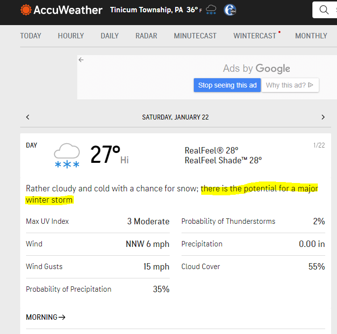
jmanley32 wrote:Gotta love th early KOD damn accuwx. Wonder what TWC says, probably already named it and it is a non existent storm lol
Don't worry jman, because the aauwx forecast says RATHER cloudy .In 61 years of reading and hearing weather forecasts I have never seen rather cloudy, just MOSTLY cloudy.
I consider this a reverse KOD.

docstox12- Wx Statistician Guru

- Posts : 8530
Reputation : 222
Join date : 2013-01-07
Age : 73
Location : Monroe NY
SENJsnowman likes this post
 Re: Long Range Discussion 22.0
heehaw453- Advanced Forecaster

- Posts : 3906
Reputation : 86
Join date : 2014-01-20
Location : Bedminster Township, PA Elevation 600' ASL
chief7, jmanley32 and Irish like this post
 Re: Long Range Discussion 22.0
ur right wth is rather cloudy? the new guy must wrote this. loldocstox12 wrote:jmanley32 wrote:Gotta love th early KOD damn accuwx. Wonder what TWC says, probably already named it and it is a non existent storm lol
Don't worry jman, because the aauwx forecast says RATHER cloudy .In 61 years of reading and hearing weather forecasts I have never seen rather cloudy, just MOSTLY cloudy.
I consider this a reverse KOD.

jmanley32- Senior Enthusiast

- Posts : 20535
Reputation : 108
Join date : 2013-12-12
Age : 43
Location : Yonkers, NY
 Re: Long Range Discussion 22.0

skinsfan1177- Senior Enthusiast

- Posts : 4485
Reputation : 35
Join date : 2013-01-07
Age : 46
Location : Point Pleasant Boro
Irish likes this post
 Re: Long Range Discussion 22.0
MattyICE- Advanced Forecaster

- Posts : 249
Reputation : 6
Join date : 2017-11-10
Age : 38
Location : Clifton, NJ (Eastern Passaic County)
amugs and Irish like this post
 Re: Long Range Discussion 22.0
The northwest trend with the developing surface cyclone is quite notable. You can also visualize the amplification trends aloft over the last several runs. pic.twitter.com/VynlryunzS
— John Homenuk (@jhomenuk) January 18, 2022
_________________
Mugs
AKA:King: Snow Weenie
Self Proclaimed
WINTER 2014-15 : 55.12" +.02 for 6 coatings (avg. 35")
WINTER 2015-16 Total - 29.8" (Avg 35")
WINTER 2016-17 : 39.5" so far

amugs- Advanced Forecaster - Mod

- Posts : 15095
Reputation : 213
Join date : 2013-01-07
Age : 54
Location : Hillsdale,NJ
 Re: Long Range Discussion 22.0
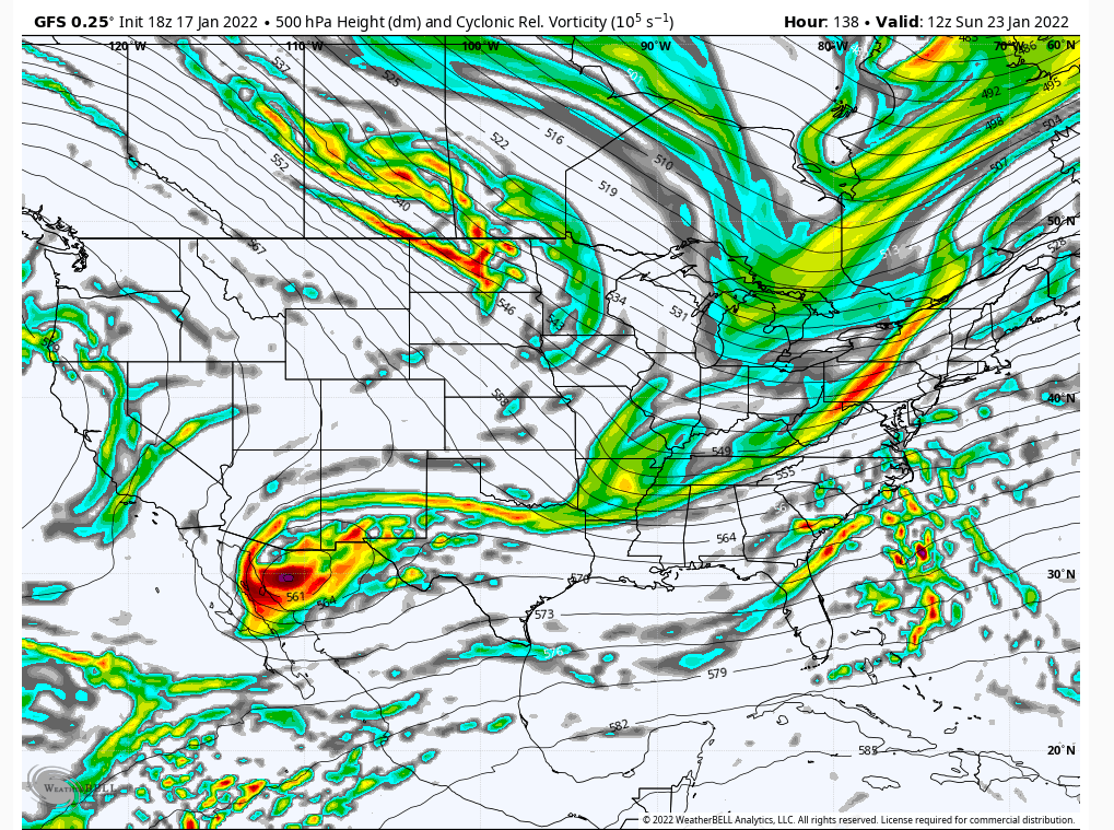
Second is the piece enetering the NW CONUS. The euro is further back and a bit further S relative to the GFS. The difference is what allows the N S/W to be either N or S (Euro or GFS). Now focus your attention on the energy circled over NW Mexico/Arizona area.
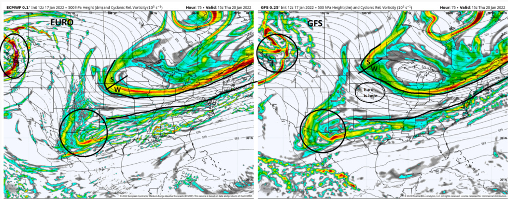
Fast forward to Hour 99. There are some really clear differences. The northers S/W on the Euro conts to dig and phase with the southern energy, hence the bomb it produced. Whereas; the GFS leaves that southern energy behind and the N S/W continues on in a progressive fashion. Why? Because look back at the energy circled out west. Euro has it as far S&W as the middle of Cali which allows ridging out ahead helping the N energy to dig; whereas the GFS has that energy MUCH further N&E over NE Nevada at best leading to a progressive flow across the N half of the CONUS. Since there is no real digging of the N energy it leaves the southern piece behind and you get no storm.
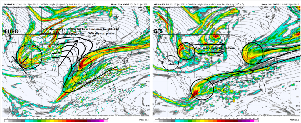
There are other areas Im looking at ie: the NAO region, 505/50 region and the GO Alaska region as well but these are key piecs that need to resolve themselves before we know how it plays out. Ironically as a known bias the Euro tends to hold southern energy back, yet it is coming out. On the flip side the GFS seems to be the most progressive with southern energy yet its holding it back. We will see how it plays out as these energies get over better sampling over the next 48hrs.
If I were a betting man this one will hit as I will be in Tennessee on Saturday soooo if it does hit....you're all welcome!!
WE TRACK!!!!!


_________________
"In weather and in life, there's no winning and losing; there's only winning and learning."
WINTER 2012/2013 TOTALS 43.65"WINTER 2017/2018 TOTALS 62.85" WINTER 2022/2023 TOTALS 4.9"
WINTER 2013/2014 TOTALS 64.85"WINTER 2018/2019 TOTALS 14.25" WINTER 2023/2024 TOTALS 13.1"
WINTER 2014/2015 TOTALS 71.20"WINTER 2019/2020 TOTALS 6.35"
WINTER 2015/2016 TOTALS 35.00"WINTER 2020/2021 TOTALS 37.75"
WINTER 2016/2017 TOTALS 42.25"WINTER 2021/2022 TOTALS 31.65"

sroc4- Admin

- Posts : 8354
Reputation : 302
Join date : 2013-01-07
Location : Wading River, LI
amugs and CPcantmeasuresnow like this post
 Re: Long Range Discussion 22.0
Just wanted to tell all the people here ( which I assume is everyone) not to worry at all about the models for Saturdays storm, because the only model you need to know is I am going away for a week this Thursday, and that in itself guarantees a major snowstorm, so enjoy the storm tracking, and don't sweat it. its a lock. I just hope I get to experience at least 1 blizzard this winter, and deff wont complain if their are many more.
dolphins222- Posts : 26
Reputation : 0
Join date : 2013-10-04
sroc4, amugs, CPcantmeasuresnow, Dunnzoo, brownie, weatherwatchermom and Bwtr like this post
 Re: Long Range Discussion 22.0
I have been insane busy. Trying to catch up as much as possible, looks like something interesting for this weekend.
We track.

Joe Snow- Pro Enthusiast

- Posts : 924
Reputation : 7
Join date : 2014-02-12
Age : 62
Location : Sanford Florida, Fmrly Kings Park, NY
sroc4, amugs and weatherwatchermom like this post
Page 29 of 31 •  1 ... 16 ... 28, 29, 30, 31
|
|
|

 Home
Home
