
 Search
Momentum building for possible storm on JAN 16th?
Page 12 of 23 •  1 ... 7 ... 11, 12, 13 ... 17 ... 23
 ![]()
Re: Momentum building for possible storm on JAN 16th?
![]() by rb924119 Thu Jan 13, 2022 11:31 am
by rb924119 Thu Jan 13, 2022 11:31 am
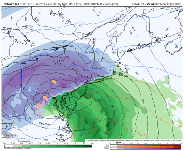
jmanley32 wrote:Do you still feel a inland runner is your bet? If I remember correctly I think that was your initial thinking or am I wrong? Do we get this offshore to get a areawide sig snowfall? Thats the question and I hope so. We all know that with this still being 4 days out that a trip back west is not out of the question.rb924119 wrote:GFS appears to be trying to pick up on the idea of my occlusion over the Mid-Atlantic, as does the ICON. Good trends.
Only up to about Virginia, then I think it occludes and redevelops off the coast. I think the models have been too aggressive driving this so far north, but we’ll see.
rb924119- Meteorologist

- Posts : 6928
Join date : 2013-02-06
jmanley32 likes this post
Re: Momentum building for possible storm on JAN 16th?
![]() by Frank_Wx Thu Jan 13, 2022 11:35 am
by Frank_Wx Thu Jan 13, 2022 11:35 am
Frank_Wx- Godzilla Seeker

- Posts : 21305
Join date : 2013-01-05 -

Re: Momentum building for possible storm on JAN 16th?
![]() by nutleyblizzard Thu Jan 13, 2022 11:43 am
by nutleyblizzard Thu Jan 13, 2022 11:43 am

nutleyblizzard- Senior Enthusiast

- Posts : 1954
Reputation : 41
Join date : 2014-01-30
Age : 58
Location : Nutley, new jersey
Re: Momentum building for possible storm on JAN 16th?
![]() by aiannone Thu Jan 13, 2022 11:57 am
by aiannone Thu Jan 13, 2022 11:57 am

_________________
-Alex Iannone-

aiannone- Senior Enthusiast - Mod

- Posts : 4815
Reputation : 92
Join date : 2013-01-07
Location : Saint James, LI (Northwest Suffolk Co.)
jmanley32, Irish and phil155 like this post
Re: Momentum building for possible storm on JAN 16th?
![]() by heehaw453 Thu Jan 13, 2022 12:18 pm
by heehaw453 Thu Jan 13, 2022 12:18 pm
heehaw453- Advanced Forecaster

- Posts : 3906
Reputation : 86
Join date : 2014-01-20
Location : Bedminster Township, PA Elevation 600' ASL
jmanley32 and SENJsnowman like this post
Re: Momentum building for possible storm on JAN 16th?
![]() by Dunnzoo Thu Jan 13, 2022 12:21 pm
by Dunnzoo Thu Jan 13, 2022 12:21 pm
mikeypizano wrote:Kiss the storm goodbye, I just prepped the big snow blower!
NO SNOW FOR YOU! We'll just keep it here in NJ.
_________________
Janet
Snowfall winter of 2023-2024 17.5"
Snowfall winter of 2022-2023 6.0"
Snowfall winter of 2021-2022 17.6" 1" sleet 2/25/22
Snowfall winter of 2020-2021 51.1"
Snowfall winter of 2019-2020 8.5"
Snowfall winter of 2018-2019 25.1"
Snowfall winter of 2017-2018 51.9"
Snowfall winter of 2016-2017 45.6"
Snowfall winter of 2015-2016 29.5"
Snowfall winter of 2014-2015 50.55"
Snowfall winter of 2013-2014 66.5"

Dunnzoo- Senior Enthusiast - Mod
- Posts : 4905
Reputation : 68
Join date : 2013-01-11
Age : 62
Location : Westwood, NJ
Re: Momentum building for possible storm on JAN 16th?
![]() by jmanley32 Thu Jan 13, 2022 12:22 pm
by jmanley32 Thu Jan 13, 2022 12:22 pm
Damn right!! LOLDunnzoo wrote:mikeypizano wrote:Kiss the storm goodbye, I just prepped the big snow blower!
NO SNOW FOR YOU! We'll just keep it here in NJ.

jmanley32- Senior Enthusiast
- Posts : 20535
Reputation : 108
Join date : 2013-12-12
Age : 43
Location : Yonkers, NY
Re: Momentum building for possible storm on JAN 16th?
![]() by mikeypizano Thu Jan 13, 2022 12:45 pm
by mikeypizano Thu Jan 13, 2022 12:45 pm
Dunnzoo wrote:mikeypizano wrote:Kiss the storm goodbye, I just prepped the big snow blower!
NO SNOW FOR YOU! We'll just keep it here in NJ.
Good, more time to play on my radio! :p

mikeypizano- Pro Enthusiast

- Posts : 1118
Reputation : 66
Join date : 2017-01-05
Age : 35
Location : Wilkes-Barre/Scranton, PA
Re: Momentum building for possible storm on JAN 16th?
![]() by RJB8525 Thu Jan 13, 2022 12:47 pm
by RJB8525 Thu Jan 13, 2022 12:47 pm

RJB8525- Senior Enthusiast
- Posts : 1994
Reputation : 28
Join date : 2013-02-06
Age : 38
Location : Hackettstown, NJ
Re: Momentum building for possible storm on JAN 16th?
![]() by mikeypizano Thu Jan 13, 2022 12:48 pm
by mikeypizano Thu Jan 13, 2022 12:48 pm
RJB8525 wrote:get those umbrellas out
Naw, this one will go straight to good ol Beantown!
mikeypizano- Pro Enthusiast
- Posts : 1118
Reputation : 66
Join date : 2017-01-05
Age : 35
Location : Wilkes-Barre/Scranton, PA
RJB8525 likes this post
Re: Momentum building for possible storm on JAN 16th?
![]() by jmanley32 Thu Jan 13, 2022 12:52 pm
by jmanley32 Thu Jan 13, 2022 12:52 pm
really hoping these are right, beautiful sight there.aiannone wrote:12z GEFS
jmanley32- Senior Enthusiast
- Posts : 20535
Reputation : 108
Join date : 2013-12-12
Age : 43
Location : Yonkers, NY
Re: Momentum building for possible storm on JAN 16th?
![]() by phil155 Thu Jan 13, 2022 12:54 pm
by phil155 Thu Jan 13, 2022 12:54 pm
RJB8525 wrote:get those umbrellas out
phil155- Pro Enthusiast
- Posts : 483
Reputation : 4
Join date : 2019-12-16
Re: Momentum building for possible storm on JAN 16th?
![]() by lglickman1 Thu Jan 13, 2022 1:13 pm
by lglickman1 Thu Jan 13, 2022 1:13 pm
lglickman1- Pro Enthusiast
- Posts : 319
Reputation : 0
Join date : 2013-02-05
Location : New Rochelle, NY
Re: Momentum building for possible storm on JAN 16th?
![]() by heehaw453 Thu Jan 13, 2022 1:16 pm
by heehaw453 Thu Jan 13, 2022 1:16 pm

heehaw453- Advanced Forecaster
- Posts : 3906
Reputation : 86
Join date : 2014-01-20
Location : Bedminster Township, PA Elevation 600' ASL
Re: Momentum building for possible storm on JAN 16th?
![]() by Frank_Wx Thu Jan 13, 2022 1:16 pm
by Frank_Wx Thu Jan 13, 2022 1:16 pm
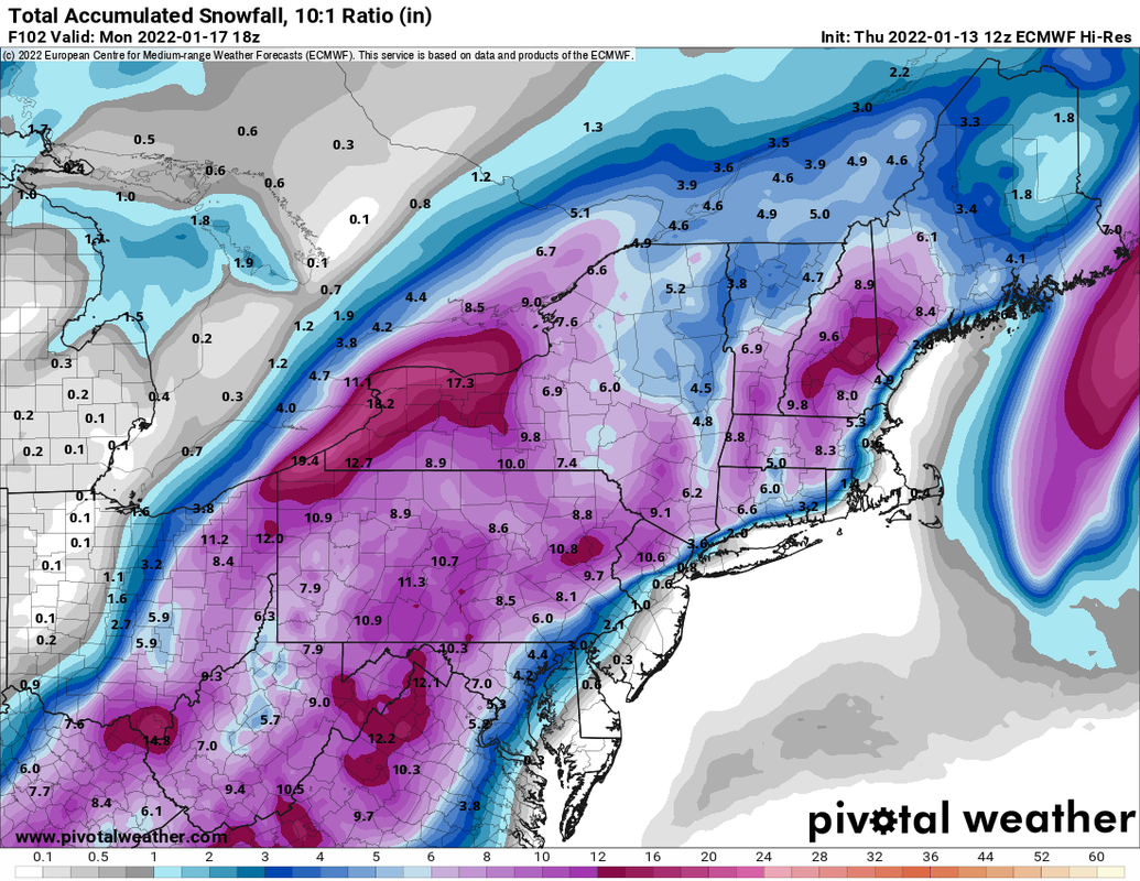
lglickman1 wrote:At this point, if the storm evolved the way the models depict it on today's runs would the i-95 corridor get any snow?
Most of us are likely to see a front-end thump of snow/sleet before changeover to rain. Some models are showing a nice front-end and then dry slotting the area. So even if temps warm, it won't rain to wash away everything. Ultimately depends on the model you look at, but today's GFS and Canadian show 1-3" of front end snows followed by heavy rain and wind.
_________________
_______________________________________________________________________________________________________
CLICK HERE to view NJ Strong Snowstorm Classifications

Frank_Wx- Godzilla Seeker
- Posts : 21305
Reputation : 328
Join date : 2013-01-05
Age : 32
Location : Jersey City, NJ -
Re: Momentum building for possible storm on JAN 16th?
![]() by nutleyblizzard Thu Jan 13, 2022 1:19 pm
by nutleyblizzard Thu Jan 13, 2022 1:19 pm
heehaw453 wrote:Heights on EC are dampened a bit with that ocean storm. Trough digs pretty far down on 12Z Euro.
…Yet it still cuts. Ugh.
nutleyblizzard- Senior Enthusiast
- Posts : 1954
Reputation : 41
Join date : 2014-01-30
Age : 58
Location : Nutley, new jersey
Re: Momentum building for possible storm on JAN 16th?
![]() by frank 638 Thu Jan 13, 2022 1:19 pm
by frank 638 Thu Jan 13, 2022 1:19 pm
I hate to say but if we’re gonna get rain Then I want this don’t happenFrank_Wx wrote:lglickman1 wrote:At this point, if the storm evolved the way the models depict it on today's runs would the i-95 corridor get any snow?
Most of us are likely to see a front-end thump of snow/sleet before changeover to rain. Some models are showing a nice front-end and then dry slotting the area. So even if temps warm, it won't rain to wash away everything. Ultimately depends on the model you look at, but today's GFS and Canadian show 1-3" of front end snows followed by heavy rain and wind.
frank 638- Senior Enthusiast
- Posts : 2843
Reputation : 37
Join date : 2016-01-01
Age : 40
Location : bronx ny
Re: Momentum building for possible storm on JAN 16th?
![]() by Frank_Wx Thu Jan 13, 2022 1:20 pm
by Frank_Wx Thu Jan 13, 2022 1:20 pm
_________________
_______________________________________________________________________________________________________
CLICK HERE to view NJ Strong Snowstorm Classifications
Frank_Wx- Godzilla Seeker
- Posts : 21305
Reputation : 328
Join date : 2013-01-05
Age : 32
Location : Jersey City, NJ -
Re: Momentum building for possible storm on JAN 16th?
![]() by Frank_Wx Thu Jan 13, 2022 1:22 pm
by Frank_Wx Thu Jan 13, 2022 1:22 pm
_________________
_______________________________________________________________________________________________________
CLICK HERE to view NJ Strong Snowstorm Classifications
Frank_Wx- Godzilla Seeker
- Posts : 21305
Reputation : 328
Join date : 2013-01-05
Age : 32
Location : Jersey City, NJ -
Re: Momentum building for possible storm on JAN 16th?
![]() by Frank_Wx Thu Jan 13, 2022 1:24 pm
by Frank_Wx Thu Jan 13, 2022 1:24 pm
I can see these trends continuing which could put more of NYC Metro in a 3-6/4-8 type of zone. As of now most models are either showing nothing or 1-3.
_________________
_______________________________________________________________________________________________________
CLICK HERE to view NJ Strong Snowstorm Classifications
Frank_Wx- Godzilla Seeker
- Posts : 21305
Reputation : 328
Join date : 2013-01-05
Age : 32
Location : Jersey City, NJ -
heehaw453 likes this post
Re: Momentum building for possible storm on JAN 16th?
![]() by heehaw453 Thu Jan 13, 2022 1:31 pm
by heehaw453 Thu Jan 13, 2022 1:31 pm

heehaw453- Advanced Forecaster
- Posts : 3906
Reputation : 86
Join date : 2014-01-20
Location : Bedminster Township, PA Elevation 600' ASL
Re: Momentum building for possible storm on JAN 16th?
![]() by heehaw453 Thu Jan 13, 2022 1:35 pm
by heehaw453 Thu Jan 13, 2022 1:35 pm

heehaw453- Advanced Forecaster
- Posts : 3906
Reputation : 86
Join date : 2014-01-20
Location : Bedminster Township, PA Elevation 600' ASL
Re: Momentum building for possible storm on JAN 16th?
![]() by mmanisca Thu Jan 13, 2022 2:27 pm
by mmanisca Thu Jan 13, 2022 2:27 pm
Frank_Wx wrote:We're seeing big enough changes today that excite me enough for nearly everyone, except maybe the immediate coast along Jersey Shore/eastern LI, to see a small to moderate accumulation before either changing to rain or getting dry slotted due to the track of the primary low.
I can see these trends continuing which could put more of NYC Metro in a 3-6/4-8 type of zone. As of now most models are either showing nothing or 1-3.
Hey Frank as I mentioned earlier another consideration is the very warm ocean temperatures sitting of the coast. We will need a good shot of WAA snows before that wind starts to freshen up. I've seen in the past where very cold temperatures vanish within hours when that wind gets going even at a moderate breeze.

mmanisca- Pro Enthusiast
- Posts : 299
Reputation : 3
Join date : 2013-01-23
Age : 65
Location : Deer Park, Long Island
Re: Momentum building for possible storm on JAN 16th?
![]() by heehaw453 Thu Jan 13, 2022 2:28 pm
by heehaw453 Thu Jan 13, 2022 2:28 pm

heehaw453- Advanced Forecaster
- Posts : 3906
Reputation : 86
Join date : 2014-01-20
Location : Bedminster Township, PA Elevation 600' ASL
Re: Momentum building for possible storm on JAN 16th?
![]() by frank 638 Thu Jan 13, 2022 2:30 pm
by frank 638 Thu Jan 13, 2022 2:30 pm
frank 638- Senior Enthusiast
- Posts : 2843
Reputation : 37
Join date : 2016-01-01
Age : 40
Location : bronx ny
Re: Momentum building for possible storm on JAN 16th?
![]() by amugs Thu Jan 13, 2022 2:46 pm
by amugs Thu Jan 13, 2022 2:46 pm
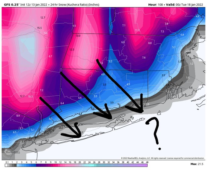
Delmarva-----> Eastern Long Island------> Boston
There's your future low track... no need to watch models anymore- your welcome
She'll follow the HP
_________________
Mugs
AKA:King: Snow Weenie
Self Proclaimed
WINTER 2014-15 : 55.12" +.02 for 6 coatings (avg. 35")
WINTER 2015-16 Total - 29.8" (Avg 35")
WINTER 2016-17 : 39.5" so far

amugs- Advanced Forecaster - Mod
- Posts : 15095
Reputation : 213
Join date : 2013-01-07
Age : 54
Location : Hillsdale,NJ
jmanley32 and heehaw453 like this post
Re: Momentum building for possible storm on JAN 16th?
![]() by jmanley32 Thu Jan 13, 2022 2:54 pm
by jmanley32 Thu Jan 13, 2022 2:54 pm
Perfect, For IMBY I dont even need to see a 30 mile drop south to be in 6-12 and I would be more than fine with that. Even 3-6 which is very close to if not IMBY, but of course this will all change in next 3 days. If your prediction is right then I wil lcrown you the genie on the forum. lolamugs wrote:Catching up here an don the model runs:
Delmarva-----> Eastern Long Island------> Boston
There's your future low track... no need to watch models anymore- your welcome
She'll follow the HP
jmanley32- Senior Enthusiast
- Posts : 20535
Reputation : 108
Join date : 2013-12-12
Age : 43
Location : Yonkers, NY
Page 12 of 23 • 1 ... 7 ... 11, 12, 13 ... 17 ... 23 ![]()
|
|
|