
 Search
Long Range Discussion 23.0
Page 17 of 26 •  1 ... 10 ... 16, 17, 18 ... 21 ... 26
 ![]()
Re: Long Range Discussion 23.0
![]() by heehaw453 Tue Jan 25, 2022 1:30 pm
by heehaw453 Tue Jan 25, 2022 1:30 pm
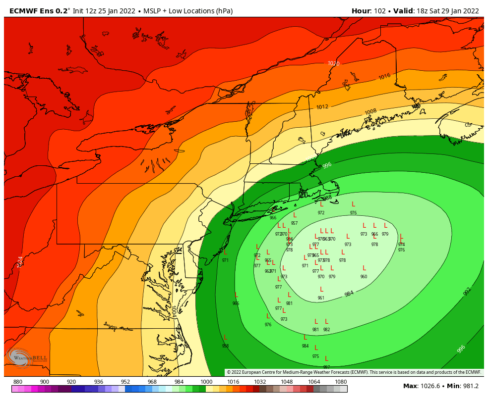
Frank_Wx wrote:Sorry I fainted.
EURO shows a Roidzilla

And i don't think this is done. I believe you'll see capture off Delmarva with this.
heehaw453- Advanced Forecaster

- Posts : 3906
Join date : 2014-01-20
Re: Long Range Discussion 23.0
![]() by Carvin Tue Jan 25, 2022 1:31 pm
by Carvin Tue Jan 25, 2022 1:31 pm
Carvin- Posts : 44
Join date : 2019-01-09
Re: Long Range Discussion 23.0
![]() by jmanley32 Tue Jan 25, 2022 1:32 pm
by jmanley32 Tue Jan 25, 2022 1:32 pm
Max 42 inches!! Frank thats ur hated snow map Kuch..era, but still dayumm. For John with the wind do you have the wind maps? LOLFrank_Wx wrote:Sorry I fainted.
EURO shows a Roidzilla

jmanley32- Senior Enthusiast

- Posts : 20516
Reputation : 108
Join date : 2013-12-12
Age : 42
Location : Yonkers, NY
Re: Long Range Discussion 23.0
![]() by amugs Tue Jan 25, 2022 1:32 pm
by amugs Tue Jan 25, 2022 1:32 pm
Frank_Wx wrote:Sorry I fainted.
EURO shows a Roidzilla
Absolutely crippling storm depicted by Euro, sprinkle in a CMC tucked or split the difference between the two pressure wise - period no questions - no one wants to hear this but the strength of this storm will produce major issues.
_________________
Mugs
AKA:King: Snow Weenie
Self Proclaimed
WINTER 2014-15 : 55.12" +.02 for 6 coatings (avg. 35")
WINTER 2015-16 Total - 29.8" (Avg 35")
WINTER 2016-17 : 39.5" so far

amugs- Advanced Forecaster - Mod

- Posts : 15093
Reputation : 213
Join date : 2013-01-07
Age : 54
Location : Hillsdale,NJ
Re: Long Range Discussion 23.0
![]() by weatherwatchermom Tue Jan 25, 2022 1:33 pm
by weatherwatchermom Tue Jan 25, 2022 1:33 pm
Carvin wrote:Why is this still in long range needs it’s own thread
no one wants to jinx anything!!

weatherwatchermom- Senior Enthusiast
- Posts : 3742
Reputation : 77
Join date : 2014-11-25
Age : 60
Location : Hazlet Township, NJ
heehaw453, phil155 and Bwtr like this post
Re: Long Range Discussion 23.0
![]() by sroc4 Tue Jan 25, 2022 1:34 pm
by sroc4 Tue Jan 25, 2022 1:34 pm
Carvin wrote:Why is this still in long range needs it’s own thread
NOT YET!!! Its a superstitious thing. Last few storms we did that too soon only to have the models literally lose the storm immediately after. Come thursday am if anything remotely similar is being show a separate thread will begin.
_________________
"In weather and in life, there's no winning and losing; there's only winning and learning."
WINTER 2012/2013 TOTALS 43.65"WINTER 2017/2018 TOTALS 62.85" WINTER 2022/2023 TOTALS 4.9"
WINTER 2013/2014 TOTALS 64.85"WINTER 2018/2019 TOTALS 14.25" WINTER 2023/2024 TOTALS 13.1"
WINTER 2014/2015 TOTALS 71.20"WINTER 2019/2020 TOTALS 6.35"
WINTER 2015/2016 TOTALS 35.00"WINTER 2020/2021 TOTALS 37.75"
WINTER 2016/2017 TOTALS 42.25"WINTER 2021/2022 TOTALS 31.65"

sroc4- Admin

- Posts : 8331
Reputation : 301
Join date : 2013-01-07
Location : Wading River, LI
heehaw453, phil155 and Bwtr like this post
Re: Long Range Discussion 23.0
![]() by mikeypizano Tue Jan 25, 2022 1:35 pm
by mikeypizano Tue Jan 25, 2022 1:35 pm
weatherwatchermom wrote:Carvin wrote:Why is this still in long range needs it’s own thread
no one wants to jinx anything!!
Sorry Mom but its too late! It was jinxed the minute it appeared! :p

mikeypizano- Pro Enthusiast

- Posts : 1118
Reputation : 66
Join date : 2017-01-05
Age : 35
Location : Wilkes-Barre/Scranton, PA
Re: Long Range Discussion 23.0
![]() by jmanley32 Tue Jan 25, 2022 1:35 pm
by jmanley32 Tue Jan 25, 2022 1:35 pm
DEF Mugs, this could be one to go down in history as shown now, still gotta temper ourselves, i wish Friday was here lol. So is this now a Sat/Sun and not Fri/Sat? And Frank upped the SCI, hope that doesn't jinx anything! Can't say that snow map did not give me butterflies lolamugs wrote:Frank_Wx wrote:Sorry I fainted.
EURO shows a Roidzilla
Absolutely crippling storm depicted by Euro, sprinkle in a CMC tucked or split the difference between the two pressure wise - period no questions - no one wants to hear this but the strength of this storm will produce major issues.
jmanley32- Senior Enthusiast
- Posts : 20516
Reputation : 108
Join date : 2013-12-12
Age : 42
Location : Yonkers, NY
Re: Long Range Discussion 23.0
![]() by jmanley32 Tue Jan 25, 2022 1:43 pm
by jmanley32 Tue Jan 25, 2022 1:43 pm
lol, which I did a bean burritobobjohnsonforthehall wrote:Frank_Wx wrote:I’ll dedicate a section of the forum to Jman and call it “John With The Wind”
Sounds a bit like he had beans for lunch...
jmanley32- Senior Enthusiast
- Posts : 20516
Reputation : 108
Join date : 2013-12-12
Age : 42
Location : Yonkers, NY
Re: Long Range Discussion 23.0
![]() by heehaw453 Tue Jan 25, 2022 1:44 pm
by heehaw453 Tue Jan 25, 2022 1:44 pm
heehaw453- Advanced Forecaster
- Posts : 3906
Reputation : 86
Join date : 2014-01-20
Location : Bedminster Township, PA Elevation 600' ASL
sroc4 and moleson like this post
Re: Long Range Discussion 23.0
![]() by CPcantmeasuresnow Tue Jan 25, 2022 2:03 pm
by CPcantmeasuresnow Tue Jan 25, 2022 2:03 pm
I'm highly skeptical that happens. But it's one run of the Euro and it is the Crapola, love it Frank, (K uchera).

CPcantmeasuresnow- Wx Statistician Guru

- Posts : 7274
Reputation : 230
Join date : 2013-01-07
Age : 103
Location : Eastern Orange County, NY
Re: Long Range Discussion 23.0
![]() by heehaw453 Tue Jan 25, 2022 2:06 pm
by heehaw453 Tue Jan 25, 2022 2:06 pm

heehaw453- Advanced Forecaster
- Posts : 3906
Reputation : 86
Join date : 2014-01-20
Location : Bedminster Township, PA Elevation 600' ASL
Re: Long Range Discussion 23.0
![]() by Frank_Wx Tue Jan 25, 2022 2:10 pm
by Frank_Wx Tue Jan 25, 2022 2:10 pm

_________________
_______________________________________________________________________________________________________
CLICK HERE to view NJ Strong Snowstorm Classifications

Frank_Wx- Godzilla Seeker
- Posts : 21305
Reputation : 328
Join date : 2013-01-05
Age : 31
Location : Jersey City, NJ -

adamfitz1969 likes this post
Re: Long Range Discussion 23.0
![]() by heehaw453 Tue Jan 25, 2022 2:12 pm
by heehaw453 Tue Jan 25, 2022 2:12 pm
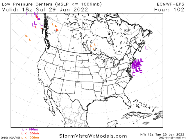
Frank_Wx wrote:The 12z ECM Ensembles look terrific
The ULL closes off early. That is the huge take away from this. I'd like to see it close off around Ocean City MD latitude.
heehaw453- Advanced Forecaster
- Posts : 3906
Reputation : 86
Join date : 2014-01-20
Location : Bedminster Township, PA Elevation 600' ASL
CPcantmeasuresnow likes this post
Re: Long Range Discussion 23.0
![]() by heehaw453 Tue Jan 25, 2022 2:16 pm
by heehaw453 Tue Jan 25, 2022 2:16 pm

heehaw453- Advanced Forecaster
- Posts : 3906
Reputation : 86
Join date : 2014-01-20
Location : Bedminster Township, PA Elevation 600' ASL
Re: Long Range Discussion 23.0
![]() by Frank_Wx Tue Jan 25, 2022 2:16 pm
by Frank_Wx Tue Jan 25, 2022 2:16 pm

_________________
_______________________________________________________________________________________________________
CLICK HERE to view NJ Strong Snowstorm Classifications
Frank_Wx- Godzilla Seeker
- Posts : 21305
Reputation : 328
Join date : 2013-01-05
Age : 31
Location : Jersey City, NJ -
Re: Long Range Discussion 23.0
![]() by heehaw453 Tue Jan 25, 2022 2:19 pm
by heehaw453 Tue Jan 25, 2022 2:19 pm
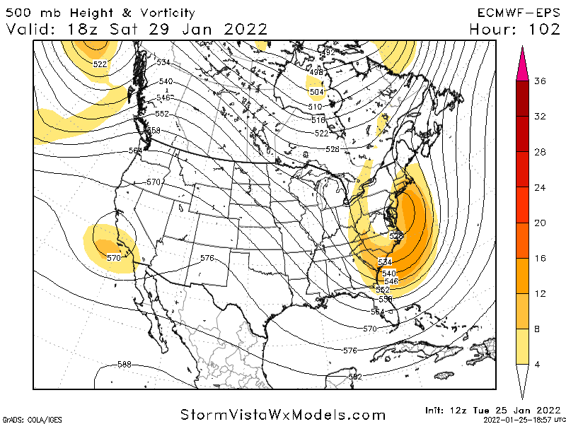
Frank_Wx wrote:The EURO Control run shows a Roidzilla at 10:1 ratios
Pin that one folks. Put it on your avatar cause that's the apex of the game we play.
heehaw453- Advanced Forecaster
- Posts : 3906
Reputation : 86
Join date : 2014-01-20
Location : Bedminster Township, PA Elevation 600' ASL
essexcountypete and Bwtr like this post
Re: Long Range Discussion 23.0
![]() by amugs Tue Jan 25, 2022 2:20 pm
by amugs Tue Jan 25, 2022 2:20 pm

It's not actually that progressive in the PAC. The flow does notably speed up once near the mid-west, moving east with an absence of high latitude blocking in the AO/NAO domains. Need to keep in mind the simple nature of a ridge. It flows anti-cyclonically. So shortwaves that ride over the top of it will naturally want to curl with the clockwise flow. That's what drives disturbances toward the four corners. I use the red lines to illustrate this, but it's easier to just follow the wind barbs.
_________________
Mugs
AKA:King: Snow Weenie
Self Proclaimed
WINTER 2014-15 : 55.12" +.02 for 6 coatings (avg. 35")
WINTER 2015-16 Total - 29.8" (Avg 35")
WINTER 2016-17 : 39.5" so far
amugs- Advanced Forecaster - Mod
- Posts : 15093
Reputation : 213
Join date : 2013-01-07
Age : 54
Location : Hillsdale,NJ
sroc4 likes this post
Re: Long Range Discussion 23.0
![]() by amugs Tue Jan 25, 2022 2:21 pm
by amugs Tue Jan 25, 2022 2:21 pm
_________________
Mugs
AKA:King: Snow Weenie
Self Proclaimed
WINTER 2014-15 : 55.12" +.02 for 6 coatings (avg. 35")
WINTER 2015-16 Total - 29.8" (Avg 35")
WINTER 2016-17 : 39.5" so far
amugs- Advanced Forecaster - Mod
- Posts : 15093
Reputation : 213
Join date : 2013-01-07
Age : 54
Location : Hillsdale,NJ
Re: Long Range Discussion 23.0
![]() by Frank_Wx Tue Jan 25, 2022 2:23 pm
by Frank_Wx Tue Jan 25, 2022 2:23 pm
amugs wrote:Frank on the question of why the energy gest hung up in the SW - great answer makes great logical sense
It's not actually that progressive in the PAC. The flow does notably speed up once near the mid-west, moving east with an absence of high latitude blocking in the AO/NAO domains. Need to keep in mind the simple nature of a ridge. It flows anti-cyclonically. So shortwaves that ride over the top of it will naturally want to curl with the clockwise flow. That's what drives disturbances toward the four corners. I use the red lines to illustrate this, but it's easier to just follow the wind barbs.
Thanks! That does make sense. I think we are a little unlucky with where the PAC jet is riding. But honestly none of this matters if the EURO has its way. We're looking at one biga spicey meataball this weekend. Would LOVE to see the GFS continue its westward trend later today.
_________________
_______________________________________________________________________________________________________
CLICK HERE to view NJ Strong Snowstorm Classifications
Frank_Wx- Godzilla Seeker
- Posts : 21305
Reputation : 328
Join date : 2013-01-05
Age : 31
Location : Jersey City, NJ -
amugs likes this post
Re: Long Range Discussion 23.0
![]() by dkodgis Tue Jan 25, 2022 2:38 pm
by dkodgis Tue Jan 25, 2022 2:38 pm

dkodgis- Senior Enthusiast
- Posts : 2501
Reputation : 98
Join date : 2013-12-29
Re: Long Range Discussion 23.0
![]() by sroc4 Tue Jan 25, 2022 2:44 pm
by sroc4 Tue Jan 25, 2022 2:44 pm
dkodgis wrote:Board members, help me out. On Fri morning I will be driving back from Buffalo to northern Orange county. When will the snow start and what will I hit? I expect to leave at 8 and be back at 1 pm.
My guess is approx 5-9pm Friday
_________________
"In weather and in life, there's no winning and losing; there's only winning and learning."
WINTER 2012/2013 TOTALS 43.65"WINTER 2017/2018 TOTALS 62.85" WINTER 2022/2023 TOTALS 4.9"
WINTER 2013/2014 TOTALS 64.85"WINTER 2018/2019 TOTALS 14.25" WINTER 2023/2024 TOTALS 13.1"
WINTER 2014/2015 TOTALS 71.20"WINTER 2019/2020 TOTALS 6.35"
WINTER 2015/2016 TOTALS 35.00"WINTER 2020/2021 TOTALS 37.75"
WINTER 2016/2017 TOTALS 42.25"WINTER 2021/2022 TOTALS 31.65"
sroc4- Admin
- Posts : 8331
Reputation : 301
Join date : 2013-01-07
Location : Wading River, LI
Re: Long Range Discussion 23.0
![]() by Irish Tue Jan 25, 2022 2:46 pm
by Irish Tue Jan 25, 2022 2:46 pm
dkodgis wrote:Board members, help me out. On Fri morning I will be driving back from Buffalo to northern Orange county. When will the snow start and what will I hit? I expect to leave at 8 and be back at 1 pm.
I think you'll be in the clear. Storm looks to hit late Friday and moreso Saturday.

Irish- Pro Enthusiast
- Posts : 788
Reputation : 19
Join date : 2019-01-16
Age : 45
Location : Old Bridge, NJ
Re: Long Range Discussion 23.0
![]() by lglickman1 Tue Jan 25, 2022 2:48 pm
by lglickman1 Tue Jan 25, 2022 2:48 pm
lglickman1- Pro Enthusiast
- Posts : 319
Reputation : 0
Join date : 2013-02-05
Location : New Rochelle, NY
Re: Long Range Discussion 23.0
![]() by Frank_Wx Tue Jan 25, 2022 2:54 pm
by Frank_Wx Tue Jan 25, 2022 2:54 pm
lglickman1 wrote:Sorry if this is a dumb question, but is there airport from other models to back the euro up? I know there have been positive trends on the gfs and the Canadian model, but they haven't shown this kind of bomb in this location, have they?
Nope
There are two models in the EURO camp and that is the JMA and RGEM
_________________
_______________________________________________________________________________________________________
CLICK HERE to view NJ Strong Snowstorm Classifications
Frank_Wx- Godzilla Seeker
- Posts : 21305
Reputation : 328
Join date : 2013-01-05
Age : 31
Location : Jersey City, NJ -
Re: Long Range Discussion 23.0
![]() by mmanisca Tue Jan 25, 2022 3:03 pm
by mmanisca Tue Jan 25, 2022 3:03 pm

mmanisca- Pro Enthusiast
- Posts : 298
Reputation : 3
Join date : 2013-01-23
Age : 65
Location : Deer Park, Long Island
Re: Long Range Discussion 23.0
![]() by Carvin Tue Jan 25, 2022 3:08 pm
by Carvin Tue Jan 25, 2022 3:08 pm
Carvin- Posts : 44
Reputation : 2
Join date : 2019-01-09
Page 17 of 26 • 1 ... 10 ... 16, 17, 18 ... 21 ... 26 ![]()
|
|
|