
 Search
Long Range Thread 24.0
Page 6 of 21 •  1 ... 5, 6, 7 ... 13 ... 21
 ![]()
Re: Long Range Thread 24.0
![]() by heehaw453 Tue Feb 08, 2022 7:54 am
by heehaw453 Tue Feb 08, 2022 7:54 am
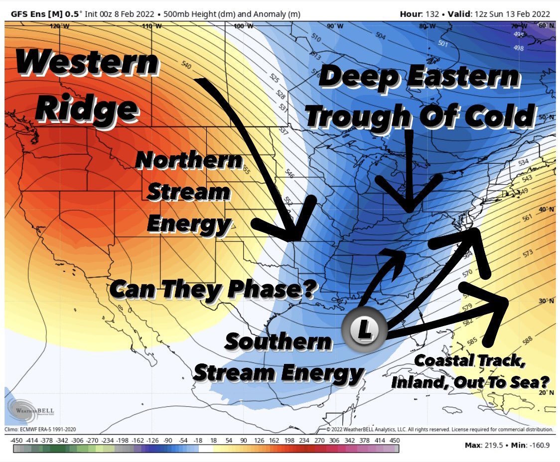
EPS. I'd like to see a more vertical orientation on the ridge to slide that n/s energy down for better phasing which brings that trough to negative state before it gets close to the coast. The ridge kind of loses its strength and this trough would probably spawn LP that slides outside of BM for a graze. Also, remember w/out Atlantic blocking there is no margin for error. It's either all right with the phase or it's minimal impacts.

heehaw453- Advanced Forecaster

- Posts : 3906
Join date : 2014-01-20
Re: Long Range Thread 24.0
![]() by amugs Tue Feb 08, 2022 9:22 am
by amugs Tue Feb 08, 2022 9:22 am
heehaw453 wrote:2/13-2/14 threat definitely of interest. Cannot be denied there are ingredients there. Below EPS is a much better look than has been and would render some local impact. Do we continue to build on this or just walk backwards a bit? I'm going with a graze on eastern zones until there is more evidence that this is something better.
EPS. I'd like to see a more vertical orientation on the ridge to slide that n/s energy down for better phasing which brings that trough to negative state before it gets close to the coast. The ridge kind of loses its strength and this trough would probably spawn LP that slides outside of BM for a graze. Also, remember w/out Atlantic blocking there is no margin for error. It's either all right with the phase or it's minimal impacts.
This is going to be what our 3rd, 4th big storm that has no blocking - ala 50/50 or NAO or even a Scan block heck a N AO would help. Without any of those this is going to be very frustrating as Doc says once the pattern settles in that's what you can expect. The blocking we had in Nov and Dec was basically wasted for teh stormy period after once the pattern flipped. Can't align the these and why snow is so remarkable.
IF again a big IF this MJO plot has substance and can come to fruition then we may just may have some blocking help in Phase 3 to get the opportunities for a good storm or two or three as it breaks down as well. The ol Archambault event.
amugs- Advanced Forecaster - Mod

- Posts : 15095
Join date : 2013-01-07
Re: Long Range Thread 24.0
![]() by hyde345 Tue Feb 08, 2022 10:28 am
by hyde345 Tue Feb 08, 2022 10:28 am

hyde345- Pro Enthusiast

- Posts : 1082
Reputation : 48
Join date : 2013-01-08
Location : Hyde Park, NY
Re: Long Range Thread 24.0
![]() by jimv45 Tue Feb 08, 2022 10:51 am
by jimv45 Tue Feb 08, 2022 10:51 am
jimv45- Senior Enthusiast

- Posts : 1168
Reputation : 36
Join date : 2013-09-20
Location : Hopewell jct.
Re: Long Range Thread 24.0
![]() by sroc4 Tue Feb 08, 2022 10:57 am
by sroc4 Tue Feb 08, 2022 10:57 am
Frank_Wx wrote:Snow88 wrote:No talk about vday weekend storm ? Getting interesting on the ensembles with the low being more phased.
I’m monitoring it. No point in getting too invested yet.
The southern energy is too fast right now. Northern energy is having a hard time catching up. No -NAO or 50/50 so we’re going to need perfect timing.

Lets not forget that as has been the theme all season long, since we don't have the Atlantic on our side we have time and time again had the poorly timed west coast energy crashing the coast stomping down the WC ridge right as we are trying to get our energy to come up the coast. The result has been either OTS because of the progressive Atlantic or coastal sections working out. Because the trailing energy is still so far out there tyhe last minute trends inside 3days will likely be no different for this set up. For better or worse.

_________________
"In weather and in life, there's no winning and losing; there's only winning and learning."
WINTER 2012/2013 TOTALS 43.65"WINTER 2017/2018 TOTALS 62.85" WINTER 2022/2023 TOTALS 4.9"
WINTER 2013/2014 TOTALS 64.85"WINTER 2018/2019 TOTALS 14.25" WINTER 2023/2024 TOTALS 13.1"
WINTER 2014/2015 TOTALS 71.20"WINTER 2019/2020 TOTALS 6.35"
WINTER 2015/2016 TOTALS 35.00"WINTER 2020/2021 TOTALS 37.75"
WINTER 2016/2017 TOTALS 42.25"WINTER 2021/2022 TOTALS 31.65"

sroc4- Admin

- Posts : 8354
Reputation : 302
Join date : 2013-01-07
Location : Wading River, LI
Re: Long Range Thread 24.0
![]() by rb924119 Tue Feb 08, 2022 11:07 am
by rb924119 Tue Feb 08, 2022 11:07 am
heehaw453 wrote:Maybe banter, mods move if appropriate.
Enough data has been captured to say Rb nailed the 500mb pattern for meteorological winter! I will say better than any LR forecast I've seen by anyone. It was extremely impressive analysis, videos and teachings. December's call really impressed the hell out of me with the anomalous RNA killing December. I thought we'd have better shots with the favorable AO/NAO.
I will most likely IMBY wind up with BN to sig BN snowfall this year and that is a testament to good patterns are not causality for deterministic snowfall. Requires luck in any pattern! But the pattern produced very nicely for coastal communities which haven't had such snowfall in years.
Please keep up the great work!
Thanks, heehaw (and Frank, SENJ), but we are only in the third quarter. I’m not spiking the football yet lol December, January, and February (so far), admittedly, have turned out very well, at least with respect to the pattern evolution. That said, we still have the rest of this month and March to get through before we can put an overall grade on the forecast.
One thing that I’m not happy about is the relative lack of snowfall for areas north and west of I-95, as I thought that if the expected pattern evolved as expected, which, it has, then the snow would follow for the entirety of our forum. As you mentioned, it really has only verified for our eastern and southern residents. So, that definitely has me a bit frustrated, but we still have time, and I think we see a return of the west-based -NAO in March, which could help our interior crew catch up in a hurry.
rb924119- Meteorologist

- Posts : 6928
Reputation : 194
Join date : 2013-02-06
Age : 32
Location : Greentown, Pa
amugs likes this post
Re: Long Range Thread 24.0
![]() by amugs Tue Feb 08, 2022 11:10 am
by amugs Tue Feb 08, 2022 11:10 am
_________________
Mugs
AKA:King: Snow Weenie
Self Proclaimed
WINTER 2014-15 : 55.12" +.02 for 6 coatings (avg. 35")
WINTER 2015-16 Total - 29.8" (Avg 35")
WINTER 2016-17 : 39.5" so far

amugs- Advanced Forecaster - Mod
- Posts : 15095
Reputation : 213
Join date : 2013-01-07
Age : 54
Location : Hillsdale,NJ
Re: Long Range Thread 24.0
![]() by rb924119 Tue Feb 08, 2022 11:12 am
by rb924119 Tue Feb 08, 2022 11:12 am
sroc4 wrote:Frank_Wx wrote:Snow88 wrote:No talk about vday weekend storm ? Getting interesting on the ensembles with the low being more phased.
I’m monitoring it. No point in getting too invested yet.
The southern energy is too fast right now. Northern energy is having a hard time catching up. No -NAO or 50/50 so we’re going to need perfect timing.
Lets not forget that as has been the theme all season long, since we don't have the Atlantic on our side we have time and time again had the poorly timed west coast energy crashing the coast stomping down the WC ridge right as we are trying to get our energy to come up the coast. The result has been either OTS because of the progressive Atlantic or coastal sections working out. Because the trailing energy is still so far out there tyhe last minute trends inside 3days will likely be no different for this set up. For better or worse.
This, but as a partial counter, we’ve also seen a seasonal tendency this year to substantially retract/slow the southern stream/lead energy while simultaneously speeding up the northern stream/secondary energy as lead time decreases. I’ve not looked at this threat, but just the factors highlighted in these two posts would seemingly support heehaw’s and SENJ/doc’s hypothesis that this ends up as an event for south and east of I-95 or a miss wide-right, all other factors being ignored.
rb924119- Meteorologist
- Posts : 6928
Reputation : 194
Join date : 2013-02-06
Age : 32
Location : Greentown, Pa
Frank_Wx, sroc4, amugs and RJB8525 like this post
Re: Long Range Thread 24.0
![]() by heehaw453 Tue Feb 08, 2022 1:40 pm
by heehaw453 Tue Feb 08, 2022 1:40 pm
heehaw453- Advanced Forecaster
- Posts : 3906
Reputation : 86
Join date : 2014-01-20
Location : Bedminster Township, PA Elevation 600' ASL
Re: Long Range Thread 24.0
![]() by sroc4 Tue Feb 08, 2022 2:05 pm
by sroc4 Tue Feb 08, 2022 2:05 pm
heehaw453 wrote:I think this V-Day threat is on life support based off D5 modeling. May need a team of specialists to save it even for mild impacts.
 Certainly cant argue based on 12z data
_________________
"In weather and in life, there's no winning and losing; there's only winning and learning."
WINTER 2012/2013 TOTALS 43.65"WINTER 2017/2018 TOTALS 62.85" WINTER 2022/2023 TOTALS 4.9"
WINTER 2013/2014 TOTALS 64.85"WINTER 2018/2019 TOTALS 14.25" WINTER 2023/2024 TOTALS 13.1"
WINTER 2014/2015 TOTALS 71.20"WINTER 2019/2020 TOTALS 6.35"
WINTER 2015/2016 TOTALS 35.00"WINTER 2020/2021 TOTALS 37.75"
WINTER 2016/2017 TOTALS 42.25"WINTER 2021/2022 TOTALS 31.65"
sroc4- Admin
- Posts : 8354
Reputation : 302
Join date : 2013-01-07
Location : Wading River, LI
heehaw453 likes this post
Re: Long Range Thread 24.0
![]() by phil155 Tue Feb 08, 2022 2:17 pm
by phil155 Tue Feb 08, 2022 2:17 pm
phil155- Pro Enthusiast
- Posts : 483
Reputation : 4
Join date : 2019-12-16
Re: Long Range Thread 24.0
![]() by heehaw453 Tue Feb 08, 2022 6:03 pm
by heehaw453 Tue Feb 08, 2022 6:03 pm
phil155 wrote:Not even getting my hopes up for this one
I think a well timed phase isn't going to happen and the main s/s energy will slide well outside the BM. However, if the n/s can interact with the s/s moisture transport then this could drop some snow. It will depend on how much digging the n/s can do, but that's the path to anything IMO.
700mb moisture

heehaw453- Advanced Forecaster
- Posts : 3906
Reputation : 86
Join date : 2014-01-20
Location : Bedminster Township, PA Elevation 600' ASL
Re: Long Range Thread 24.0
![]() by docstox12 Tue Feb 08, 2022 7:21 pm
by docstox12 Tue Feb 08, 2022 7:21 pm
rb924119 wrote:heehaw453 wrote:Maybe banter, mods move if appropriate.
Enough data has been captured to say Rb nailed the 500mb pattern for meteorological winter! I will say better than any LR forecast I've seen by anyone. It was extremely impressive analysis, videos and teachings. December's call really impressed the hell out of me with the anomalous RNA killing December. I thought we'd have better shots with the favorable AO/NAO.
I will most likely IMBY wind up with BN to sig BN snowfall this year and that is a testament to good patterns are not causality for deterministic snowfall. Requires luck in any pattern! But the pattern produced very nicely for coastal communities which haven't had such snowfall in years.
Please keep up the great work!
Thanks, heehaw (and Frank, SENJ), but we are only in the third quarter. I’m not spiking the football yet lol December, January, and February (so far), admittedly, have turned out very well, at least with respect to the pattern evolution. That said, we still have the rest of this month and March to get through before we can put an overall grade on the forecast.
One thing that I’m not happy about is the relative lack of snowfall for areas north and west of I-95, as I thought that if the expected pattern evolved as expected, which, it has, then the snow would follow for the entirety of our forum. As you mentioned, it really has only verified for our eastern and southern residents. So, that definitely has me a bit frustrated, but we still have time, and I think we see a return of the west-based -NAO in March, which could help our interior crew catch up in a hurry.
rb, patterns can and do change , even one as long lasting as this has been for the N and W crew, so until there is no time left, I will keep up hopes for a big one up here.March and even April up in the LHV can produce big time.In early April when my gf at the time, to be wife, moved into a new home, the next day there was 13 inches of snow.March 2018 there was 27 inches with a few hours of 3 to 4 inch rates under a band.Hey, we wait MONTHS from May to November for winter weather so every day of snow time is valuable!

docstox12- Wx Statistician Guru

- Posts : 8530
Reputation : 222
Join date : 2013-01-07
Age : 73
Location : Monroe NY
amugs and SENJsnowman like this post
Re: Long Range Thread 24.0
![]() by rb924119 Wed Feb 09, 2022 3:10 am
by rb924119 Wed Feb 09, 2022 3:10 am
docstox12 wrote:rb924119 wrote:heehaw453 wrote:Maybe banter, mods move if appropriate.
Enough data has been captured to say Rb nailed the 500mb pattern for meteorological winter! I will say better than any LR forecast I've seen by anyone. It was extremely impressive analysis, videos and teachings. December's call really impressed the hell out of me with the anomalous RNA killing December. I thought we'd have better shots with the favorable AO/NAO.
I will most likely IMBY wind up with BN to sig BN snowfall this year and that is a testament to good patterns are not causality for deterministic snowfall. Requires luck in any pattern! But the pattern produced very nicely for coastal communities which haven't had such snowfall in years.
Please keep up the great work!
Thanks, heehaw (and Frank, SENJ), but we are only in the third quarter. I’m not spiking the football yet lol December, January, and February (so far), admittedly, have turned out very well, at least with respect to the pattern evolution. That said, we still have the rest of this month and March to get through before we can put an overall grade on the forecast.
One thing that I’m not happy about is the relative lack of snowfall for areas north and west of I-95, as I thought that if the expected pattern evolved as expected, which, it has, then the snow would follow for the entirety of our forum. As you mentioned, it really has only verified for our eastern and southern residents. So, that definitely has me a bit frustrated, but we still have time, and I think we see a return of the west-based -NAO in March, which could help our interior crew catch up in a hurry.
rb, patterns can and do change , even one as long lasting as this has been for the N and W crew, so until there is no time left, I will keep up hopes for a big one up here.March and even April up in the LHV can produce big time.In early April when my gf at the time, to be wife, moved into a new home, the next day there was 13 inches of snow.March 2018 there was 27 inches with a few hours of 3 to 4 inch rates under a band.Hey, we wait MONTHS from May to November for winter weather so every day of snow time is valuable!
Oo I know, doc. I’m not giving up hope yet either
rb924119- Meteorologist
- Posts : 6928
Reputation : 194
Join date : 2013-02-06
Age : 32
Location : Greentown, Pa
Re: Long Range Thread 24.0
![]() by rb924119 Wed Feb 09, 2022 3:27 am
by rb924119 Wed Feb 09, 2022 3:27 am
I have to look a bit deeper, but I like the idea of the MJO biasing cold, at least into the opening week of March, while the Stratospheric PV begins to start losing influence, but only gradually. This is the same evolution that I’ve been following since my initial thoughts, and if it rings true, it should allow heights to build across Canada while simultaneously trapping a time-mean trough to the south via the processes that I mentioned a few days ago (I think?). Should be an interesting month, for sure, in my opinion
rb924119- Meteorologist
- Posts : 6928
Reputation : 194
Join date : 2013-02-06
Age : 32
Location : Greentown, Pa
Re: Long Range Thread 24.0
![]() by frank 638 Wed Feb 09, 2022 5:22 am
by frank 638 Wed Feb 09, 2022 5:22 am
frank 638- Senior Enthusiast
- Posts : 2843
Reputation : 37
Join date : 2016-01-01
Age : 40
Location : bronx ny
Re: Long Range Thread 24.0
![]() by algae888 Wed Feb 09, 2022 5:55 am
by algae888 Wed Feb 09, 2022 5:55 am

algae888- Advanced Forecaster
- Posts : 5311
Reputation : 46
Join date : 2013-02-05
Age : 62
Location : mt. vernon, new york
Re: Long Range Thread 24.0
![]() by algae888 Wed Feb 09, 2022 5:57 am
by algae888 Wed Feb 09, 2022 5:57 am
algae888- Advanced Forecaster
- Posts : 5311
Reputation : 46
Join date : 2013-02-05
Age : 62
Location : mt. vernon, new york
Re: Long Range Thread 24.0
![]() by heehaw453 Wed Feb 09, 2022 6:29 am
by heehaw453 Wed Feb 09, 2022 6:29 am
note the consolidation of the moisture transport

Note the energy around the trough and n/s coming in strong with meridional interaction to the trough.

heehaw453- Advanced Forecaster
- Posts : 3906
Reputation : 86
Join date : 2014-01-20
Location : Bedminster Township, PA Elevation 600' ASL
Re: Long Range Thread 24.0
![]() by amugs Wed Feb 09, 2022 6:30 am
by amugs Wed Feb 09, 2022 6:30 am

_________________
Mugs
AKA:King: Snow Weenie
Self Proclaimed
WINTER 2014-15 : 55.12" +.02 for 6 coatings (avg. 35")
WINTER 2015-16 Total - 29.8" (Avg 35")
WINTER 2016-17 : 39.5" so far
amugs- Advanced Forecaster - Mod
- Posts : 15095
Reputation : 213
Join date : 2013-01-07
Age : 54
Location : Hillsdale,NJ
Re: Long Range Thread 24.0
![]() by amugs Wed Feb 09, 2022 6:40 am
by amugs Wed Feb 09, 2022 6:40 am

_________________
Mugs
AKA:King: Snow Weenie
Self Proclaimed
WINTER 2014-15 : 55.12" +.02 for 6 coatings (avg. 35")
WINTER 2015-16 Total - 29.8" (Avg 35")
WINTER 2016-17 : 39.5" so far
amugs- Advanced Forecaster - Mod
- Posts : 15095
Reputation : 213
Join date : 2013-01-07
Age : 54
Location : Hillsdale,NJ
Frank_Wx and dolphins222 like this post
Re: Long Range Thread 24.0
![]() by sroc4 Wed Feb 09, 2022 7:13 am
by sroc4 Wed Feb 09, 2022 7:13 am
The key is if the S piece can get out ahead of the N piece. If it can as the 00z and even more so the 6z GFS is currently depicting then you will get interactions into the back side of the S energy and it will act to tilt our trough towards neutral, perhaps even neg, and develop a storm closer to the coast and get precip into the area. If not then the N flow keeps the trough positive and progressive like the euro shows.
How much interaction and how far N&W we can get the precip will be entirely on the timing and strength of these interactions and if we can tilt the trough. It goes without say, I think, that areas along the coast are def favored in this set up, but everyone is still in play for accumulation still.
There is still a long way to go with this folks, for better or worse. Dont get too high and dont get too low.


_________________
"In weather and in life, there's no winning and losing; there's only winning and learning."
WINTER 2012/2013 TOTALS 43.65"WINTER 2017/2018 TOTALS 62.85" WINTER 2022/2023 TOTALS 4.9"
WINTER 2013/2014 TOTALS 64.85"WINTER 2018/2019 TOTALS 14.25" WINTER 2023/2024 TOTALS 13.1"
WINTER 2014/2015 TOTALS 71.20"WINTER 2019/2020 TOTALS 6.35"
WINTER 2015/2016 TOTALS 35.00"WINTER 2020/2021 TOTALS 37.75"
WINTER 2016/2017 TOTALS 42.25"WINTER 2021/2022 TOTALS 31.65"
sroc4- Admin
- Posts : 8354
Reputation : 302
Join date : 2013-01-07
Location : Wading River, LI
kalleg likes this post
Re: Long Range Thread 24.0
![]() by sroc4 Wed Feb 09, 2022 7:51 am
by sroc4 Wed Feb 09, 2022 7:51 am
sroc4 wrote:Pretty simple folks. Here is your differences between snow potential and a swing and miss. GFS vs Euro respectively.
The key is if the S piece can get out ahead of the N piece. If it can as the 00z and even more so the 6z GFS is currently depicting then you will get interactions into the back side of the S energy and it will act to tilt our trough towards neutral, perhaps even neg, and develop a storm closer to the coast and get precip into the area. If not then the N flow keeps the trough positive and progressive like the euro shows.
How much interaction and how far N&W we can get the precip will be entirely on the timing and strength of these interactions and if we can tilt the trough. It goes without say, I think, that areas along the coast are def favored in this set up, but everyone is still in play for accumulation still.
There is still a long way to go with this folks, for better or worse. Dont get too high and dont get too low.
Also pay attention to the trailing energy in the images above. This particular energy is still way out S and W of the Aleutian Islands as of 7am this am. If you look at the image below its embedded within the circle labeled 3.
For additional reference as of 7am this am, the energy that is the "S" piece is the circle labeled 1, and the "N" piece is actually the circle labeled 2 along with some of the leading energy in the circled labeled 3. Our S energy, currently in the northern Gulf Of Alaska, either interacts with or does not the sub trop jet stream energy, which is really the energy that initially generates the storm. The "S" energy, and N energy will simply add to it or not. Will either steer it OTS or steer it closer to the coast; all depending on how much interaction occurs, and the timing of the N and S pieces.
So you can see 1) why the models cont to shift the exact timing and positioning of the main players from run to run still and from model to model, and 2) Why all season we have seen the final soln hold out until we are inside 2-3days. The beating of a dead horse comment coming, but since the Atlantic has not been of help it's been the Pac side of things that have dictated the timing of these interactions. With the last piece to the puzzle, circle number 3, not coming ashore until Saturday, and the N piece, circle number 2, not entering northern Canada until later Thursday, (perhaps very early Friday), and the S piece just entering the extreme NW NA throughout today one can make a strong argument that states dont get to caught up in todays finer details on the models. Thursday 12z is when I think we begin to se the meeting of the minds(GFS and Euro), and it's more likely 12z Friday that we can start adjusting the fine tune knob at the earliest.
Focus on H5: The timing, position AND strength of the three main pieces I highlighted above and below using the 06z GFS as you're reference to build off what we want to see.
1) S piece must be out ahead of the N piece. If not it WILL get shunted OTS
2) How strong are the S and N piece. I believe Ray had mentioned this point, but as we get in close and sampling for models improves as the energy comes ashore the trend has been to show more robust energy than earlier modeled. So far that trend is starting to hold true to form.
3) IF the S piece is out ahead, by how much and what's the timing between the interaction of N and S energy relative to the coast
4) WE TRACK!!!!


_________________
"In weather and in life, there's no winning and losing; there's only winning and learning."
WINTER 2012/2013 TOTALS 43.65"WINTER 2017/2018 TOTALS 62.85" WINTER 2022/2023 TOTALS 4.9"
WINTER 2013/2014 TOTALS 64.85"WINTER 2018/2019 TOTALS 14.25" WINTER 2023/2024 TOTALS 13.1"
WINTER 2014/2015 TOTALS 71.20"WINTER 2019/2020 TOTALS 6.35"
WINTER 2015/2016 TOTALS 35.00"WINTER 2020/2021 TOTALS 37.75"
WINTER 2016/2017 TOTALS 42.25"WINTER 2021/2022 TOTALS 31.65"
sroc4- Admin
- Posts : 8354
Reputation : 302
Join date : 2013-01-07
Location : Wading River, LI
kalleg, heehaw453 and SENJsnowman like this post
Re: Long Range Thread 24.0
![]() by Frank_Wx Wed Feb 09, 2022 8:32 am
by Frank_Wx Wed Feb 09, 2022 8:32 am
sroc4 wrote:Pretty simple folks. Here is your differences between snow potential and a swing and miss. GFS vs Euro respectively.
The key is if the S piece can get out ahead of the N piece. If it can as the 00z and even more so the 6z GFS is currently depicting then you will get interactions into the back side of the S energy and it will act to tilt our trough towards neutral, perhaps even neg, and develop a storm closer to the coast and get precip into the area. If not then the N flow keeps the trough positive and progressive like the euro shows.
How much interaction and how far N&W we can get the precip will be entirely on the timing and strength of these interactions and if we can tilt the trough. It goes without say, I think, that areas along the coast are def favored in this set up, but everyone is still in play for accumulation still.
There is still a long way to go with this folks, for better or worse. Dont get too high and dont get too low.
I don't like the strung out look of the 'southern' energy as that may be the reason why it's progressing faster than the northern piece. Would like to see it separate and become its own entity over the next couple of days. Would also solve the lower heights issue I'm noticing over the northeast.
_________________
_______________________________________________________________________________________________________
CLICK HERE to view NJ Strong Snowstorm Classifications

Frank_Wx- Godzilla Seeker
- Posts : 21305
Reputation : 328
Join date : 2013-01-05
Age : 32
Location : Jersey City, NJ -

SENJsnowman likes this post
Re: Long Range Thread 24.0
![]() by SENJsnowman Wed Feb 09, 2022 8:43 am
by SENJsnowman Wed Feb 09, 2022 8:43 am
Frank_Wx wrote:sroc4 wrote:Pretty simple folks. Here is your differences between snow potential and a swing and miss. GFS vs Euro respectively.
The key is if the S piece can get out ahead of the N piece. If it can as the 00z and even more so the 6z GFS is currently depicting then you will get interactions into the back side of the S energy and it will act to tilt our trough towards neutral, perhaps even neg, and develop a storm closer to the coast and get precip into the area. If not then the N flow keeps the trough positive and progressive like the euro shows.
How much interaction and how far N&W we can get the precip will be entirely on the timing and strength of these interactions and if we can tilt the trough. It goes without say, I think, that areas along the coast are def favored in this set up, but everyone is still in play for accumulation still.
There is still a long way to go with this folks, for better or worse. Dont get too high and dont get too low.
I don't like the strung out look of the 'southern' energy as that may be the reason why it's progressing faster than the northern piece. Would like to see it separate and become its own entity over the next couple of days. Would also solve the lower heights issue I'm noticing over the northeast.
Thanks Frank- now I know exactly what to track today! So for the heights issue, we want those black lines hooking more due NE up from the Carolinas and Delmarva than the ENE that they are currently heading?
SENJsnowman- Senior Enthusiast
- Posts : 1189
Reputation : 61
Join date : 2017-01-06
Age : 51
Location : Bayville, NJ
Re: Long Range Thread 24.0
![]() by heehaw453 Wed Feb 09, 2022 9:01 am
by heehaw453 Wed Feb 09, 2022 9:01 am
SENJsnowman wrote:Frank_Wx wrote:sroc4 wrote:Pretty simple folks. Here is your differences between snow potential and a swing and miss. GFS vs Euro respectively.
The key is if the S piece can get out ahead of the N piece. If it can as the 00z and even more so the 6z GFS is currently depicting then you will get interactions into the back side of the S energy and it will act to tilt our trough towards neutral, perhaps even neg, and develop a storm closer to the coast and get precip into the area. If not then the N flow keeps the trough positive and progressive like the euro shows.
How much interaction and how far N&W we can get the precip will be entirely on the timing and strength of these interactions and if we can tilt the trough. It goes without say, I think, that areas along the coast are def favored in this set up, but everyone is still in play for accumulation still.
There is still a long way to go with this folks, for better or worse. Dont get too high and dont get too low.
I don't like the strung out look of the 'southern' energy as that may be the reason why it's progressing faster than the northern piece. Would like to see it separate and become its own entity over the next couple of days. Would also solve the lower heights issue I'm noticing over the northeast.
Thanks Frank- now I know exactly what to track today! So for the heights issue, we want those black lines hooking more due NE up from the Carolinas and Delmarva than the ENE that they are currently heading?
You want the n/s coming down strong and hard on the back side of the 500mb trough to bring it neutral more quickly. Once neutral as the energy consolidates the trough has a much better shot at going negative before it hits the coast which pulls moisture back much more efficiently. If the n/s interaction is poor or that energy is weak this is 1-3" even at the coast.
heehaw453- Advanced Forecaster
- Posts : 3906
Reputation : 86
Join date : 2014-01-20
Location : Bedminster Township, PA Elevation 600' ASL
SENJsnowman likes this post
Re: Long Range Thread 24.0
![]() by sroc4 Wed Feb 09, 2022 9:48 am
by sroc4 Wed Feb 09, 2022 9:48 am
_________________
"In weather and in life, there's no winning and losing; there's only winning and learning."
WINTER 2012/2013 TOTALS 43.65"WINTER 2017/2018 TOTALS 62.85" WINTER 2022/2023 TOTALS 4.9"
WINTER 2013/2014 TOTALS 64.85"WINTER 2018/2019 TOTALS 14.25" WINTER 2023/2024 TOTALS 13.1"
WINTER 2014/2015 TOTALS 71.20"WINTER 2019/2020 TOTALS 6.35"
WINTER 2015/2016 TOTALS 35.00"WINTER 2020/2021 TOTALS 37.75"
WINTER 2016/2017 TOTALS 42.25"WINTER 2021/2022 TOTALS 31.65"
sroc4- Admin
- Posts : 8354
Reputation : 302
Join date : 2013-01-07
Location : Wading River, LI
CPcantmeasuresnow and heehaw453 like this post
Page 6 of 21 • 1 ... 5, 6, 7 ... 13 ... 21 ![]()
|
|
|