Long Range Thread 24.0
+38
richb521
freezerburn
moleson
WeatherBob
Grselig
essexcountypete
algae888
frank 638
docstox12
jimv45
SENJsnowman
MattyICE
adamfitz1969
Dunnzoo
CPcantmeasuresnow
dsix85
Koroptim
phil155
dkodgis
weatherwatchermom
mmanisca
sroc4
mikeypizano
nutleyblizzard
jmanley32
TheAresian
heehaw453
Snow88
hyde345
Sparky Sparticles
SoulSingMG
aiannone
lglickman1
Irish
rb924119
amugs
SNOW MAN
Frank_Wx
42 posters
Page 5 of 21
Page 5 of 21 •  1, 2, 3, 4, 5, 6 ... 13 ... 21
 Re: Long Range Thread 24.0
Nice maps Al. I personally think the pattern for the first half of February isn’t bad, but we’ll enter a dry stretch after tonight’s storm passes.
 Re: Long Range Thread 24.0
Frank or whoever can answer this…when does the sun angle start impacting accumulating snow?
dsix85- Pro Enthusiast

- Posts : 349
Join date : 2014-01-01
 Re: Long Range Thread 24.0
dsix85 wrote:Frank or whoever can answer this…when does the sun angle start impacting accumulating snow?
It only affects snow accumulating when it’s at lighter rates with borderline temperatures. That will happen at anytime but of course becomes more and more noticeable as we approach the spring equinox and beyond.
Heavier snowfall rates are not affected and if the temperatures are in the 20’s it’s negligible. We just had accumulating snow two years ago on May 9 when temps stayed in the low to mid 30’s during the day and a fairly heavy snow squall deposited an inch of snow here in the middle of the afternoon.
Of course the later in the season it is, the higher sun angles melt snow after the fact much faster than a mid December sun would at the same outdoor temperature.

CPcantmeasuresnow- Wx Statistician Guru

- Posts : 7274
Reputation : 230
Join date : 2013-01-07
Age : 103
Location : Eastern Orange County, NY
sroc4 and billg315 like this post
 Re: Long Range Thread 24.0
dsix85 wrote:Frank or whoever can answer this…when does the sun angle start impacting accumulating snow?
For our area alongthe coast I would say generally speaking I start hearing people say that come the month of March; maybe the last week of Feb. But like CP said it really only affects when there is very light snowfall and marginal temps. When a decent storm hits its not the sun angle to worry about but rather the storm track that determines most of the outcome. Esp us coasties, any storm track that begins to flirt with inside the bench mark quickly turns to the warm sector for us. That statement; however, tends to hold true for any time during the winter. but margins for error drops rapidly in the later 1/3rd of the season.
_________________
"In weather and in life, there's no winning and losing; there's only winning and learning."
WINTER 2012/2013 TOTALS 43.65"WINTER 2017/2018 TOTALS 62.85" WINTER 2022/2023 TOTALS 4.9"
WINTER 2013/2014 TOTALS 64.85"WINTER 2018/2019 TOTALS 14.25" WINTER 2023/2024 TOTALS 13.1"
WINTER 2014/2015 TOTALS 71.20"WINTER 2019/2020 TOTALS 6.35"
WINTER 2015/2016 TOTALS 35.00"WINTER 2020/2021 TOTALS 37.75"
WINTER 2016/2017 TOTALS 42.25"WINTER 2021/2022 TOTALS 31.65"

sroc4- Admin

- Posts : 8354
Reputation : 302
Join date : 2013-01-07
Location : Wading River, LI
CPcantmeasuresnow likes this post
 Re: Long Range Thread 24.0
You know winter is nearing its end when the board starts debating sun angle 
Koroptim- Posts : 29
Reputation : 0
Join date : 2013-01-16
Frank_Wx, sroc4, heehaw453, Sparky Sparticles, billg315, Irish and JT33 like this post
 Re: Long Range Thread 24.0
My take on the long range. I put some of this in the February discussion, but believe it belongs here.
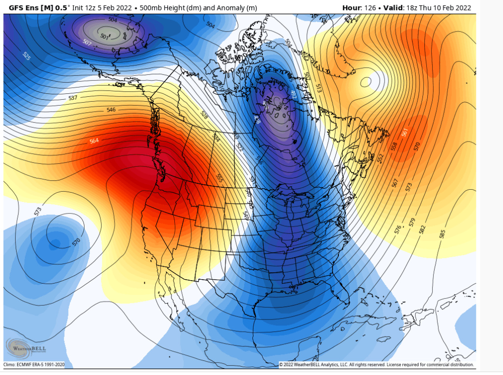
There will be cold air around as the TPV elongates and drops down toward eastern side of Hudson Bay after 2/10 compliments of favorable EPO/PNA. Our window will last about last 10-14 days. The window will be mitigated by a so-so arctic/Atlantic domain which continues the progressive pattern. And then I believe the arctic will go hostile mid month and effects manifest towards the end of February. So then in March you have not a wave spacing concern like January/Feb because March requires less spacing for amplification of s/w, but we will turn warmer faster than your typical March.
Here is best look that we have left IMO for something large scale. My belief is coastal folks get one more sig event before curtains are closed on their snow season. Interior and 95 folks sorry, but I feel fringing due to progressive pattern will continue right until chances cease and believe they cease earlier than normal this season.
edited
After 10th of the month look.

Last edited by heehaw453 on Sat Feb 05, 2022 11:39 am; edited 1 time in total
heehaw453- Advanced Forecaster

- Posts : 3906
Reputation : 86
Join date : 2014-01-20
Location : Bedminster Township, PA Elevation 600' ASL
 Re: Long Range Thread 24.0
I just turned over the soil in the garden. Where are the robins?

Irish- Pro Enthusiast

- Posts : 788
Reputation : 19
Join date : 2019-01-16
Age : 45
Location : Old Bridge, NJ
 Re: Long Range Thread 24.0
At this point, I'm not worried about meeting my average snowfall total. I'm off to Hawaii in 3 weeks and don't want any storms messing with my flights! On the other hand, I wouldn't mind getting stuck there if a storm shows up around St. Patty's day! lol This just hasn't been a snow-year for us in NENJ, and I'm not going to get my hopes up anymore.
_________________
Janet
Snowfall winter of 2023-2024 17.5"
Snowfall winter of 2022-2023 6.0"
Snowfall winter of 2021-2022 17.6" 1" sleet 2/25/22
Snowfall winter of 2020-2021 51.1"
Snowfall winter of 2019-2020 8.5"
Snowfall winter of 2018-2019 25.1"
Snowfall winter of 2017-2018 51.9"
Snowfall winter of 2016-2017 45.6"
Snowfall winter of 2015-2016 29.5"
Snowfall winter of 2014-2015 50.55"
Snowfall winter of 2013-2014 66.5"
Dunnzoo- Senior Enthusiast - Mod

- Posts : 4905
Reputation : 68
Join date : 2013-01-11
Age : 62
Location : Westwood, NJ
Frank_Wx, heehaw453 and Sparky Sparticles like this post
 Re: Long Range Thread 24.0
Koroptim wrote:You know winter is nearing its end when the board starts debating sun angle
Hahahaha
_________________
_______________________________________________________________________________________________________
CLICK HERE to view NJ Strong Snowstorm Classifications
adamfitz1969- Posts : 122
Reputation : 14
Join date : 2018-03-01
Age : 54
Location : Tarrytown
 Re: Long Range Thread 24.0
12z Euro, 12z CMC, and 18z GFS all have something noteworthy for the Valentine’s Day time period. Little PNA spike. Little transient pseudo NAO. Let’s see where this goes …
MattyICE- Advanced Forecaster

- Posts : 249
Reputation : 6
Join date : 2017-11-10
Age : 38
Location : Clifton, NJ (Eastern Passaic County)

jmanley32- Senior Enthusiast

- Posts : 20535
Reputation : 108
Join date : 2013-12-12
Age : 43
Location : Yonkers, NY
 Re: Long Range Thread 24.0
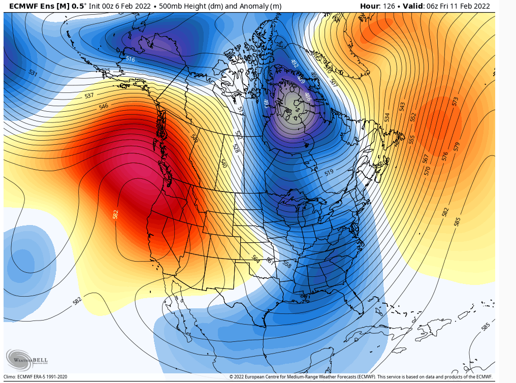
The time frame IMO is from 2/11-2/14 for something large scale. I am not a believer of large scale snow events in NYC area in February as the AO goes plus 2 sigma positive as that starts hostile territory. That starts 2/15 or so. Nope highly unlikely IMO and there is vast data to back that up. But here around 2/11 we are flexing the NAO a bit with a slightly positive AO ( <= 1 sigma). Good PNA/EPO and that can work IMO in February. Something well timed could pop here and I'd favor coastal areas as the ridge axis will probably push off far enough east to push energy more outside BM just as it has most of the past 6 weeks. Window for small/moderate scale stuff on the table until after 2/24 IMO as the AO effect will take time.

heehaw453- Advanced Forecaster

- Posts : 3906
Reputation : 86
Join date : 2014-01-20
Location : Bedminster Township, PA Elevation 600' ASL
heehaw453- Advanced Forecaster

- Posts : 3906
Reputation : 86
Join date : 2014-01-20
Location : Bedminster Township, PA Elevation 600' ASL
 Re: Long Range Thread 24.0
Maybe banter, mods move if appropriate.
Enough data has been captured to say Rb nailed the 500mb pattern for meteorological winter! I will say better than any LR forecast I've seen by anyone. It was extremely impressive analysis, videos and teachings. December's call really impressed the hell out of me with the anomalous RNA killing December. I thought we'd have better shots with the favorable AO/NAO.
I will most likely IMBY wind up with BN to sig BN snowfall this year and that is a testament to good patterns are not causality for deterministic snowfall. Requires luck in any pattern! But the pattern produced very nicely for coastal communities which haven't had such snowfall in years.
Please keep up the great work!
heehaw453- Advanced Forecaster

- Posts : 3906
Reputation : 86
Join date : 2014-01-20
Location : Bedminster Township, PA Elevation 600' ASL
docstox12, amugs, CPcantmeasuresnow, brownie and MattyICE like this post
 Re: Long Range Thread 24.0
heehaw453 wrote:Maybe banter, mods move if appropriate.
Enough data has been captured to say Rb nailed the 500mb pattern for meteorological winter! I will say better than any LR forecast I've seen by anyone. It was extremely impressive analysis, videos and teachings. December's call really impressed the hell out of me with the anomalous RNA killing December. I thought we'd have better shots with the favorable AO/NAO.
I will most likely IMBY wind up with BN to sig BN snowfall this year and that is a testament to good patterns are not causality for deterministic snowfall. Requires luck in any pattern! But the pattern produced very nicely for coastal communities which haven't had such snowfall in years.
Please keep up the great work!
3 winters ago, many of us learned a huge lesson: Until the pattern actually flips, all the indications of the flip are nothing more than indications.
This winter, the big takeaway I think is the bolded portion from your summary. As recently as this past December, I thought that if the pattern did flip, that the snowstorms were essentially guaranteed. That the pattern was deterministic of snow storms. Not at all the case. You need the pattern, and THEN the breaks to fall within the pattern to get the snow. Tough hobby/passion! lol
SENJsnowman- Senior Enthusiast

- Posts : 1189
Reputation : 61
Join date : 2017-01-06
Age : 51
Location : Bayville, NJ
docstox12, CPcantmeasuresnow, kalleg and Zhukov1945 like this post
 Re: Long Range Thread 24.0
_________________
Mugs
AKA:King: Snow Weenie
Self Proclaimed
WINTER 2014-15 : 55.12" +.02 for 6 coatings (avg. 35")
WINTER 2015-16 Total - 29.8" (Avg 35")
WINTER 2016-17 : 39.5" so far

amugs- Advanced Forecaster - Mod

- Posts : 15095
Reputation : 213
Join date : 2013-01-07
Age : 54
Location : Hillsdale,NJ
 Re: Long Range Thread 24.0
The 2/11/-2/14 is not very impressive on ensemble means right now. n/s/ & s/s/ too far apart from getting anything meaningful going. The Euro Op looked close last night.
At a higher level, the SOI values haven't been negative in 3 weeks, so less active subtropical jet may do this opportunity in. That's kind of where my thoughts are with this one. Even if it gets going think it's a scraper for our eastern folks. We shall see.
At a higher level, the SOI values haven't been negative in 3 weeks, so less active subtropical jet may do this opportunity in. That's kind of where my thoughts are with this one. Even if it gets going think it's a scraper for our eastern folks. We shall see.
heehaw453- Advanced Forecaster

- Posts : 3906
Reputation : 86
Join date : 2014-01-20
Location : Bedminster Township, PA Elevation 600' ASL
 Re: Long Range Thread 24.0
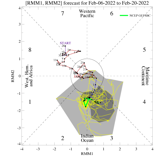
MJO Phase 3
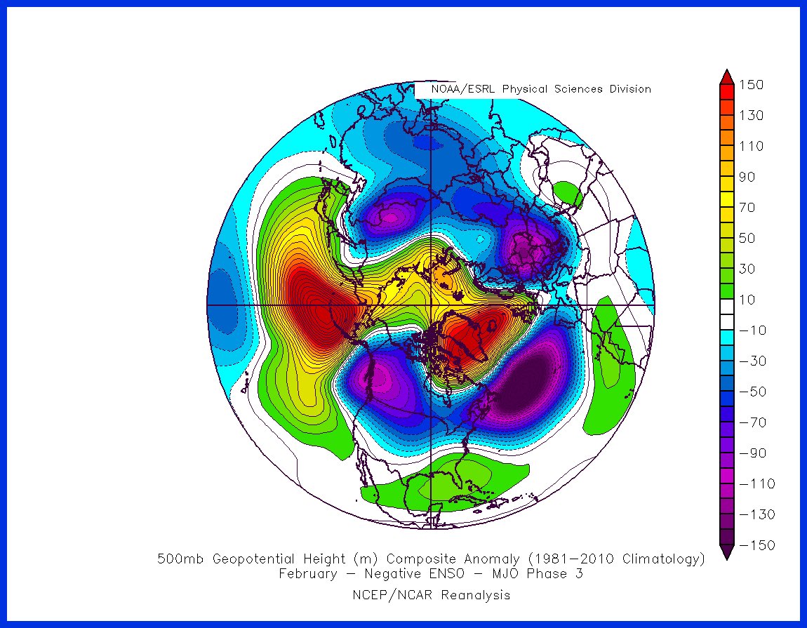
Now we are in Phase 2 - not that great for East Coast
SE Ridge Flexes
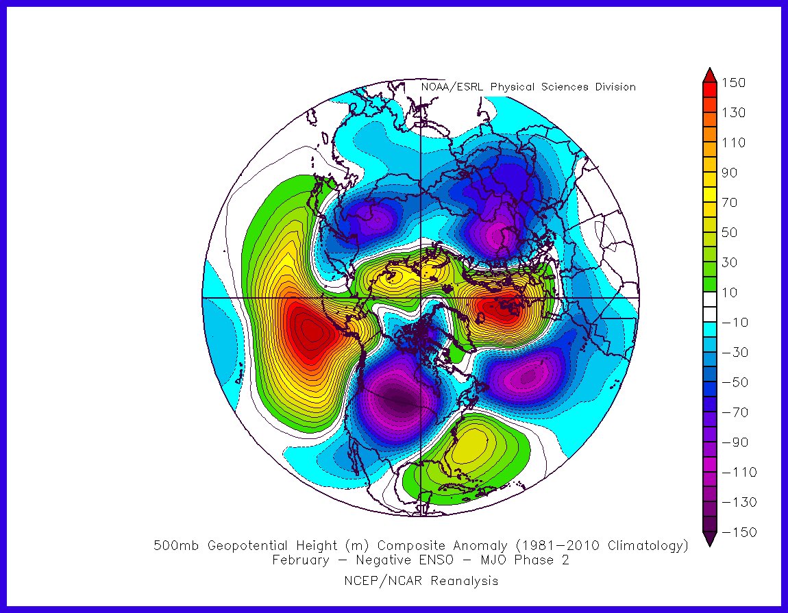
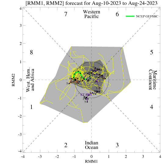
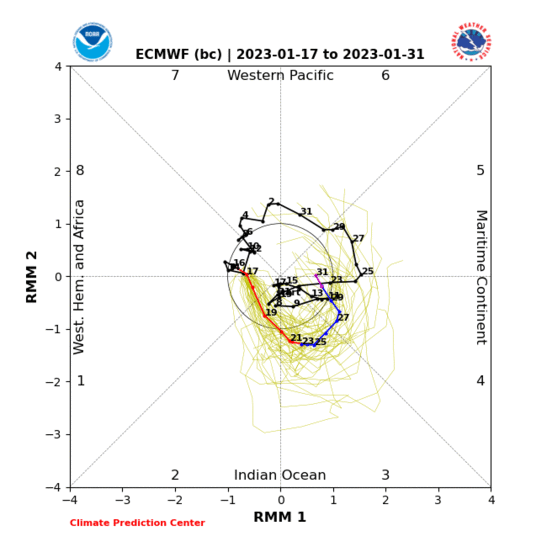

Now we are in Phase 2 - not that great for East Coast
SE Ridge Flexes


_________________
Mugs
AKA:King: Snow Weenie
Self Proclaimed
WINTER 2014-15 : 55.12" +.02 for 6 coatings (avg. 35")
WINTER 2015-16 Total - 29.8" (Avg 35")
WINTER 2016-17 : 39.5" so far

amugs- Advanced Forecaster - Mod

- Posts : 15095
Reputation : 213
Join date : 2013-01-07
Age : 54
Location : Hillsdale,NJ
 Re: Long Range Thread 24.0
Pretty remarkable how strong the Strat PV has been this winter. Nowhere near SSWE status. We have had to rely on favorable trop forcing to setup the -EPO/+PNA pattern that has resulted in continuous cold and some snow chances.
Looking ahead it seems it’s much the same, but the MJO is currently in a warm phase which means we’re likely to see more warmer than colder than normal type of weather. Once we get past mid February there’s a chance things go back to sustained cold.
That said, I still very much like the storm signal near Valentines Day. That one is not far off on current modeling from producing something significant. I’ll be watching trends closely this week.
_________________
_______________________________________________________________________________________________________
CLICK HERE to view NJ Strong Snowstorm Classifications
amugs, mmanisca and dolphins222 like this post
 Re: Long Range Thread 24.0
No talk about vday weekend storm ? Getting interesting on the ensembles with the low being more phased.

Snow88- Senior Enthusiast

- Posts : 2193
Reputation : 4
Join date : 2013-01-09
Age : 35
Location : Brooklyn, NY
 Re: Long Range Thread 24.0
Meh, bring on spring! This has been one horrible winter! Grade F

mikeypizano- Pro Enthusiast

- Posts : 1118
Reputation : 66
Join date : 2017-01-05
Age : 35
Location : Wilkes-Barre/Scranton, PA
 Re: Long Range Thread 24.0
Snow88 wrote:No talk about vday weekend storm ? Getting interesting on the ensembles with the low being more phased.
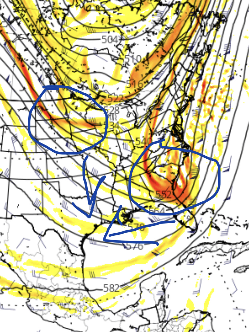
I’m monitoring it. No point in getting too invested yet.
The southern energy is too fast right now. Northern energy is having a hard time catching up. No -NAO or 50/50 so we’re going to need perfect timing.
_________________
_______________________________________________________________________________________________________
CLICK HERE to view NJ Strong Snowstorm Classifications
 Re: Long Range Thread 24.0
mikeypizano wrote:Meh, bring on spring! This has been one horrible winter! Grade F
Banter thread, please!
_________________
_______________________________________________________________________________________________________
CLICK HERE to view NJ Strong Snowstorm Classifications
 Re: Long Range Thread 24.0
Frank_Wx wrote:mikeypizano wrote:Meh, bring on spring! This has been one horrible winter! Grade F
Banter thread, please!
Sorry posted it in wrong one by mistake.

mikeypizano- Pro Enthusiast

- Posts : 1118
Reputation : 66
Join date : 2017-01-05
Age : 35
Location : Wilkes-Barre/Scranton, PA
 Re: Long Range Thread 24.0
2/13-2/14 threat definitely of interest. Cannot be denied there are ingredients there. Below EPS is a much better look than has been and would render some local impact. Do we continue to build on this or just walk backwards a bit? I'm going with a graze on eastern zones until there is more evidence that this is something better.
EPS. I'd like to see a more vertical orientation on the ridge to slide that n/s energy down for better phasing which brings that trough to negative state before it gets close to the coast. The ridge kind of loses its strength and this trough would probably spawn LP that slides outside of BM for a graze. Also, remember w/out Atlantic blocking there is no margin for error. It's either all right with the phase or it's minimal impacts.
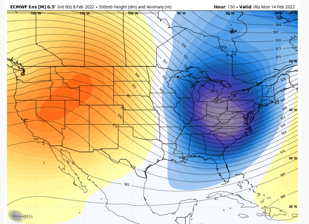
EPS. I'd like to see a more vertical orientation on the ridge to slide that n/s energy down for better phasing which brings that trough to negative state before it gets close to the coast. The ridge kind of loses its strength and this trough would probably spawn LP that slides outside of BM for a graze. Also, remember w/out Atlantic blocking there is no margin for error. It's either all right with the phase or it's minimal impacts.

heehaw453- Advanced Forecaster

- Posts : 3906
Reputation : 86
Join date : 2014-01-20
Location : Bedminster Township, PA Elevation 600' ASL
 Re: Long Range Thread 24.0
heehaw453 wrote:2/13-2/14 threat definitely of interest. Cannot be denied there are ingredients there. Below EPS is a much better look than has been and would render some local impact. Do we continue to build on this or just walk backwards a bit? I'm going with a graze on eastern zones until there is more evidence that this is something better.
EPS. I'd like to see a more vertical orientation on the ridge to slide that n/s energy down for better phasing which brings that trough to negative state before it gets close to the coast. The ridge kind of loses its strength and this trough would probably spawn LP that slides outside of BM for a graze. Also, remember w/out Atlantic blocking there is no margin for error. It's either all right with the phase or it's minimal impacts.
This is going to be what our 3rd, 4th big storm that has no blocking - ala 50/50 or NAO or even a Scan block heck a N AO would help. Without any of those this is going to be very frustrating as Doc says once the pattern settles in that's what you can expect. The blocking we had in Nov and Dec was basically wasted for teh stormy period after once the pattern flipped. Can't align the these and why snow is so remarkable.
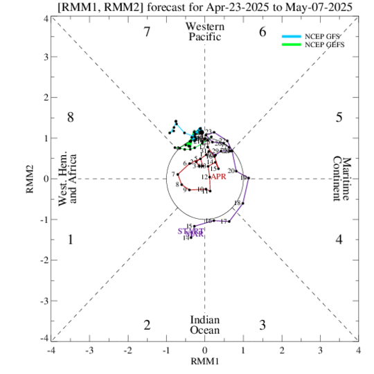
IF again a big IF this MJO plot has substance and can come to fruition then we may just may have some blocking help in Phase 3 to get the opportunities for a good storm or two or three as it breaks down as well. The ol Archambault event.
_________________
Mugs
AKA:King: Snow Weenie
Self Proclaimed
WINTER 2014-15 : 55.12" +.02 for 6 coatings (avg. 35")
WINTER 2015-16 Total - 29.8" (Avg 35")
WINTER 2016-17 : 39.5" so far

amugs- Advanced Forecaster - Mod

- Posts : 15095
Reputation : 213
Join date : 2013-01-07
Age : 54
Location : Hillsdale,NJ
Page 5 of 21 •  1, 2, 3, 4, 5, 6 ... 13 ... 21
Page 5 of 21
Permissions in this forum:
You cannot reply to topics in this forum|
|
|

 Home
Home
