
 Search
Long Range Thread 25.0
Page 3 of 40 •  1, 2, 3, 4 ... 21 ... 40
 ![]()
Re: Long Range Thread 25.0
![]() by heehaw453 Wed Nov 16, 2022 2:06 pm
by heehaw453 Wed Nov 16, 2022 2:06 pm
Hey folks! Good to see the board getting active for the impending winter months. That pattern Mugs is how it gets done around these parts. If that sets up shop in the winter months plan on lots of activity. We'll see and hope for best.amugs wrote:From Usawx board Blizzard post. WPS and GEFS both on board for a 2010 Dec similar set up.
Neg NAO and AO and WPO with a neutral PNA

heehaw453- Advanced Forecaster

- Posts : 3906
Join date : 2014-01-20
amugs and Grselig like this post
Re: Long Range Thread 25.0
![]() by amugs Wed Nov 16, 2022 2:27 pm
by amugs Wed Nov 16, 2022 2:27 pm
This is encouraging:\
Upcoming pop in EPO after record-breaking low levels this week follows similar themes from late November 2017, 2010, and 1995. Would watch for another EPO dip by early December thanks to La Niña volatility. pic.twitter.com/EA8bD0TCa0
— Commodity Wx Group (@commoditywx) November 16, 2022
amugs- Advanced Forecaster - Mod

- Posts : 15093
Join date : 2013-01-07
Re: Long Range Thread 25.0
![]() by weatherwatchermom Wed Nov 16, 2022 5:01 pm
by weatherwatchermom Wed Nov 16, 2022 5:01 pm
amugs wrote:weatherwatchermom wrote:This Saturday or the sat after Thanksgiving?...we are traveling internationally this Saturdayamugs wrote:LOTS OF UNCERTAINTY IN THE LONG RANGE FORECAST... MDLS HINTING AT A POSBL SIGNIFICANT EVENT SETTING UP AROUND T-DAY... IMAGE 06Z GFS INSIDE 8 DAYS .. #TAMPICO LOW LIFTING OUT OF THE GULF OF MEXICO... IF YOU DON'T KNOW YOU BETTER @AXE SOMEBODY... @SurfSkiWeather @NWSBoston pic.twitter.com/Y6qVZTaN9h
— DaBuh (@DaDaBuh) November 15, 2022
This would be a Miller A that on this porjected path would be a storm for us on Saturdayish
Of Thanksgiving Day weekend
Thanks Mugs...keep us posted please..prob won't have reliable internet where we are going, but will check in when I can.
Happy Thanksgiving to you and your family!

weatherwatchermom- Senior Enthusiast

- Posts : 3735
Reputation : 77
Join date : 2014-11-25
Age : 60
Location : Hazlet Township, NJ
Re: Long Range Thread 25.0
![]() by Frank_Wx Thu Nov 17, 2022 11:27 am
by Frank_Wx Thu Nov 17, 2022 11:27 am

_________________
_______________________________________________________________________________________________________
CLICK HERE to view NJ Strong Snowstorm Classifications

Frank_Wx- Godzilla Seeker

- Posts : 21305
Reputation : 328
Join date : 2013-01-05
Age : 31
Location : Jersey City, NJ -

kalleg, MattyICE and Irish like this post
Re: Long Range Thread 25.0
![]() by sroc4 Thu Nov 17, 2022 11:34 am
by sroc4 Thu Nov 17, 2022 11:34 am
Frank_Wx wrote:Tell you what... the storm signal around Thanksgiving is grabbing my attention.....
First key thing Im maybe seeing is a trend in a stronger PNA ridge. One of the first important keys IMHO
_________________
"In weather and in life, there's no winning and losing; there's only winning and learning."
WINTER 2012/2013 TOTALS 43.65"WINTER 2017/2018 TOTALS 62.85" WINTER 2022/2023 TOTALS 4.9"
WINTER 2013/2014 TOTALS 64.85"WINTER 2018/2019 TOTALS 14.25" WINTER 2023/2024 TOTALS 13.1"
WINTER 2014/2015 TOTALS 71.20"WINTER 2019/2020 TOTALS 6.35"
WINTER 2015/2016 TOTALS 35.00"WINTER 2020/2021 TOTALS 37.75"
WINTER 2016/2017 TOTALS 42.25"WINTER 2021/2022 TOTALS 31.65"

sroc4- Admin
- Posts : 8331
Reputation : 301
Join date : 2013-01-07
Location : Wading River, LI
Re: Long Range Thread 25.0
![]() by nutleyblizzard Thu Nov 17, 2022 11:46 am
by nutleyblizzard Thu Nov 17, 2022 11:46 am
Much colder air is also pressing down ahead of the storm. There is some good potential on the table with this albeit a bit too soon to take it seriously. If the signal is still there this weekend, then it would be time to open up a thread.sroc4 wrote:Frank_Wx wrote:Tell you what... the storm signal around Thanksgiving is grabbing my attention.....
First key thing Im maybe seeing is a trend in a stronger PNA ridge. One of the first important keys IMHO

nutleyblizzard- Senior Enthusiast
- Posts : 1952
Reputation : 41
Join date : 2014-01-30
Age : 58
Location : Nutley, new jersey
Re: Long Range Thread 25.0
![]() by sroc4 Thu Nov 17, 2022 12:57 pm
by sroc4 Thu Nov 17, 2022 12:57 pm
nutleyblizzard wrote:Much colder air is also pressing down ahead of the storm. There is some good potential on the table with this albeit a bit too soon to take it seriously. If the signal is still there this weekend, then it would be time to open up a thread.sroc4 wrote:Frank_Wx wrote:Tell you what... the storm signal around Thanksgiving is grabbing my attention.....
First key thing Im maybe seeing is a trend in a stronger PNA ridge. One of the first important keys IMHO
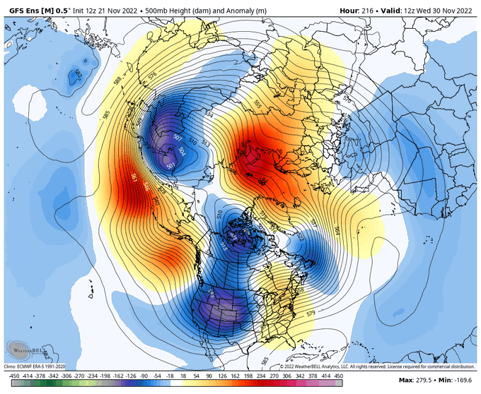
For sure. A few really import pieces to look at just for perspective. The energy that is our storm is currently positioned well out over the N Pac. labeled 2. The circle labeled 1 is energy that may or may lead to a strong enough PNA ridge on the west coast behind or digging energy 2, and label 3 is what could be our pseudo block and source of confluence ahead of our storm currently situated over Santa's house near the N Pole.
As you can see by the second image it won't be until about Tuesday wed before our storms energy reaches the west coast of NA. Still a long way off on this one and other moving parts not mentioned as well to iron out. BUT it is certainly intriguing and something to track for now.


Last edited by sroc4 on Sat Nov 19, 2022 8:40 am; edited 1 time in total
_________________
"In weather and in life, there's no winning and losing; there's only winning and learning."
WINTER 2012/2013 TOTALS 43.65"WINTER 2017/2018 TOTALS 62.85" WINTER 2022/2023 TOTALS 4.9"
WINTER 2013/2014 TOTALS 64.85"WINTER 2018/2019 TOTALS 14.25" WINTER 2023/2024 TOTALS 13.1"
WINTER 2014/2015 TOTALS 71.20"WINTER 2019/2020 TOTALS 6.35"
WINTER 2015/2016 TOTALS 35.00"WINTER 2020/2021 TOTALS 37.75"
WINTER 2016/2017 TOTALS 42.25"WINTER 2021/2022 TOTALS 31.65"
sroc4- Admin
- Posts : 8331
Reputation : 301
Join date : 2013-01-07
Location : Wading River, LI
Re: Long Range Thread 25.0
![]() by amugs Thu Nov 17, 2022 5:08 pm
by amugs Thu Nov 17, 2022 5:08 pm

_________________
Mugs
AKA:King: Snow Weenie
Self Proclaimed
WINTER 2014-15 : 55.12" +.02 for 6 coatings (avg. 35")
WINTER 2015-16 Total - 29.8" (Avg 35")
WINTER 2016-17 : 39.5" so far

amugs- Advanced Forecaster - Mod
- Posts : 15093
Reputation : 213
Join date : 2013-01-07
Age : 54
Location : Hillsdale,NJ
Re: Long Range Thread 25.0
![]() by dkodgis Sat Nov 19, 2022 8:13 am
by dkodgis Sat Nov 19, 2022 8:13 am
Are the viscerals ready?
Are the entrails right?
Who among us will champion the forecast!
Doc? CP? Mugs? Scott? Janet? Mom? Al? ?

dkodgis- Senior Enthusiast
- Posts : 2496
Reputation : 98
Join date : 2013-12-29
Re: Long Range Thread 25.0
![]() by sroc4 Sat Nov 19, 2022 9:14 am
by sroc4 Sat Nov 19, 2022 9:14 am
sroc4 wrote:nutleyblizzard wrote:Much colder air is also pressing down ahead of the storm. There is some good potential on the table with this albeit a bit too soon to take it seriously. If the signal is still there this weekend, then it would be time to open up a thread.sroc4 wrote:Frank_Wx wrote:Tell you what... the storm signal around Thanksgiving is grabbing my attention.....
First key thing Im maybe seeing is a trend in a stronger PNA ridge. One of the first important keys IMHO
For sure. A few really import pieces to look at just for perspective. The energy that is our storm is currently positioned well out over the N Pac. labeled 2. The circle labeled 1 is energy that may or may lead to a strong enough PNA ridge on the west coast behind or digging energy 2, and label 3 is what could be our pseudo block and source of confluence ahead of our storm currently situated over Santa's house near the N Pole.
As you can see by the second image it won't be until about Tuesday wed before our storms energy reaches the west coast of NA. Still a long way off on this one and other moving parts not mentioned as well to iron out. BUT it is certainly intriguing and something to track for now.
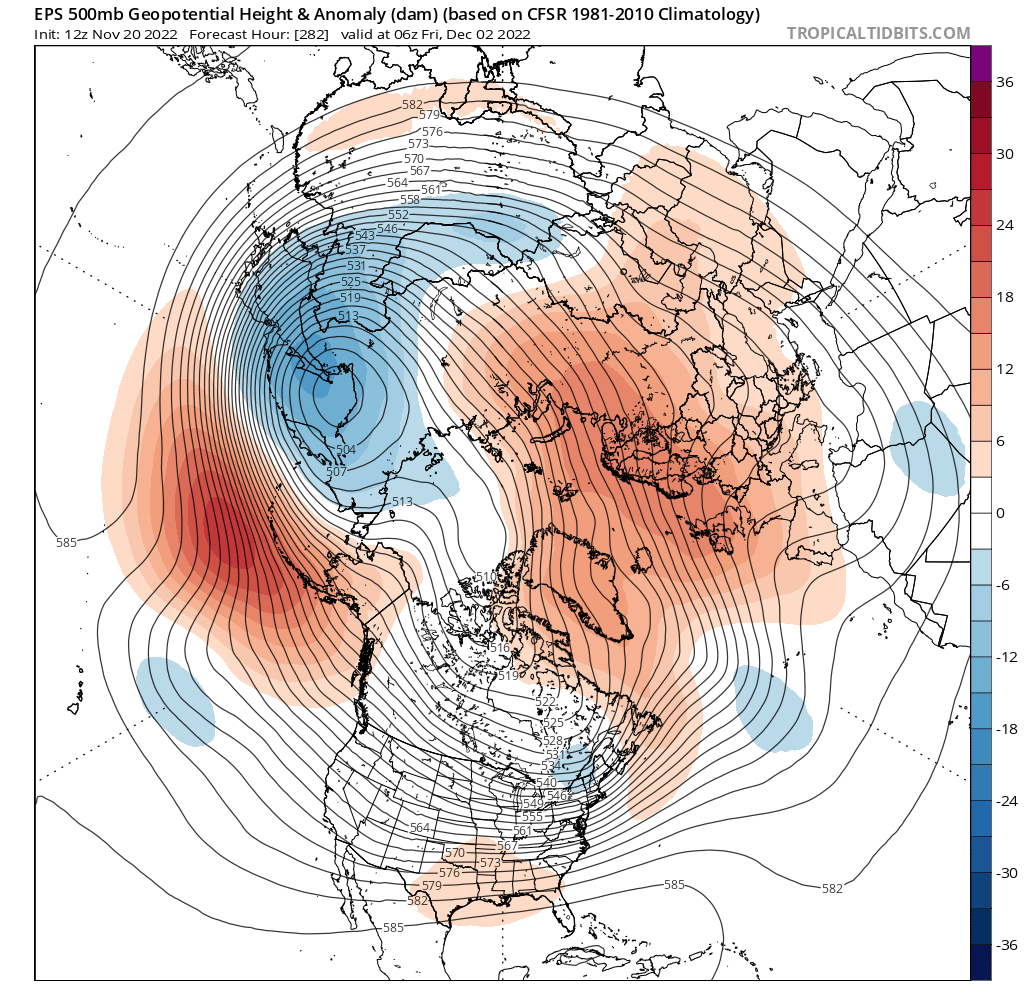
Quick update on the late week potential. Unfort while there are a few things trending for the better, overall I think the big picture trend has been trending for the worse, if cold and snow potential is what we are looking for (let's be real, for 99% of us on here that's EXACTLY what we are looking for


Positive trends:
1) The spacing between energy labeled 1 & 2 is such that the +PNA western ridge has trended more amplified
2) The NAO region over Greenland has trended negative
Negative Trends:
1) Our ridge axis and trough axis are too far west and positively tilted
2) Energy 3, which was going to hopefully act as a 50/50 low, is positioned too far N&W which lifts the confluence zone too far north
3) Because 3 is positioned where it is there is too much room ahead of our system to raise heights along he coast.
4) Our system, 2, is very amped as it digs into the heartland of the CONUS and amplifies too early.


To me the key feature here is energy 3. With it currently being modeled where it is the confluence zone is way too far north. The reason this is so important is the confluence zone is what locks the cold air in place and pushes back on the western Atlantic ridge (WAR). Because our system, 2, is so amplified it very quickly out ahead of it raises heights. Without resistance, ie: the confluence zone, the WAR amplifies raising heights along the coast. As you can plainly see from the images I posted above this shifts our upper level wind pattern from the SW which floods the coast with warm air ahead of the system.
We are starting to see a model consensus with some of these big picture features; however, Im not totally ready to write the system off just yet, esp for the NW folks because there is a -NAO showing up in the modeling. If this feature, -NAO, conts to trend a little stronger and/or a tad further east in its positioning we could see a trend a tad further S with 3 which would shift our area of confluence further S into new England, which in turn allows the cold air to stick around longer, which in turn forces our system further S&E etc etc etc. My guess is if we see 3 trend more favorable position we also see a shift to a PNA ridge axis further east as well and a more neutral to maybe even slt neg trough axis. Im not holding my breath here because other big ticket features like the MJO and La Nina background state aren't exactly lining up. That said Ill give it a few more days.
Have a wonderful weekend
We track..

_________________
"In weather and in life, there's no winning and losing; there's only winning and learning."
WINTER 2012/2013 TOTALS 43.65"WINTER 2017/2018 TOTALS 62.85" WINTER 2022/2023 TOTALS 4.9"
WINTER 2013/2014 TOTALS 64.85"WINTER 2018/2019 TOTALS 14.25" WINTER 2023/2024 TOTALS 13.1"
WINTER 2014/2015 TOTALS 71.20"WINTER 2019/2020 TOTALS 6.35"
WINTER 2015/2016 TOTALS 35.00"WINTER 2020/2021 TOTALS 37.75"
WINTER 2016/2017 TOTALS 42.25"WINTER 2021/2022 TOTALS 31.65"
sroc4- Admin
- Posts : 8331
Reputation : 301
Join date : 2013-01-07
Location : Wading River, LI
1190ftalt and dkodgis like this post
Re: Long Range Thread 25.0
![]() by Frank_Wx Sat Nov 19, 2022 12:49 pm
by Frank_Wx Sat Nov 19, 2022 12:49 pm
_________________
_______________________________________________________________________________________________________
CLICK HERE to view NJ Strong Snowstorm Classifications
Frank_Wx- Godzilla Seeker
- Posts : 21305
Reputation : 328
Join date : 2013-01-05
Age : 31
Location : Jersey City, NJ -
Re: Long Range Thread 25.0
![]() by heehaw453 Sat Nov 19, 2022 3:47 pm
by heehaw453 Sat Nov 19, 2022 3:47 pm


heehaw453- Advanced Forecaster
- Posts : 3906
Reputation : 86
Join date : 2014-01-20
Location : Bedminster Township, PA Elevation 600' ASL
Re: Long Range Thread 25.0
![]() by amugs Sat Nov 19, 2022 11:16 pm
by amugs Sat Nov 19, 2022 11:16 pm

_________________
Mugs
AKA:King: Snow Weenie
Self Proclaimed
WINTER 2014-15 : 55.12" +.02 for 6 coatings (avg. 35")
WINTER 2015-16 Total - 29.8" (Avg 35")
WINTER 2016-17 : 39.5" so far
amugs- Advanced Forecaster - Mod
- Posts : 15093
Reputation : 213
Join date : 2013-01-07
Age : 54
Location : Hillsdale,NJ
Re: Long Range Thread 25.0
![]() by Frank_Wx Sun Nov 20, 2022 9:06 am
by Frank_Wx Sun Nov 20, 2022 9:06 am
heehaw453 wrote:This is tough to work in November IMO as the NAO/AO relaxes, but mid-December onward it can work very well. I'll be interested to see the AO/NAO and how the La Nina and its orientation affect these regions. I always first look at these domains before I look elsewhere especially in the I-95 NYC-PHL area. Rare exceptions to that do occur as 2014/15 winter was excellent which had east based blocking and excellent PAC providing cold air and intensification of storms.
By Fall of 2014 I’m pretty sure ENSO was already approaching El Niño status. So that winter saw more of a Nino than Nina setup. I miss those Nino years. We’re due…
_________________
_______________________________________________________________________________________________________
CLICK HERE to view NJ Strong Snowstorm Classifications
Frank_Wx- Godzilla Seeker
- Posts : 21305
Reputation : 328
Join date : 2013-01-05
Age : 31
Location : Jersey City, NJ -
heehaw453 likes this post
Re: Long Range Thread 25.0
![]() by amugs Sun Nov 20, 2022 9:43 am
by amugs Sun Nov 20, 2022 9:43 am
Frank_Wx wrote:heehaw453 wrote:This is tough to work in November IMO as the NAO/AO relaxes, but mid-December onward it can work very well. I'll be interested to see the AO/NAO and how the La Nina and its orientation affect these regions. I always first look at these domains before I look elsewhere especially in the I-95 NYC-PHL area. Rare exceptions to that do occur as 2014/15 winter was excellent which had east based blocking and excellent PAC providing cold air and intensification of storms.
By Fall of 2014 I’m pretty sure ENSO was already approaching El Niño status. So that winter saw more of a Nino than Nina setup. I miss those Nino years. We’re due…
Models show next summer we start to get to a Nino phase of ENSO or mid-Spring. Time will tell.

This is oh so close, about 4-6 hrs to late but it on the table. From USA wx on Twitter maps. Rain to backside wet flakes for NNJ and CT. LHV would see maybe a whitening of the ground. But darn this ramps up and bombs out as it head up into the Gulf of Maine.
_________________
Mugs
AKA:King: Snow Weenie
Self Proclaimed
WINTER 2014-15 : 55.12" +.02 for 6 coatings (avg. 35")
WINTER 2015-16 Total - 29.8" (Avg 35")
WINTER 2016-17 : 39.5" so far
amugs- Advanced Forecaster - Mod
- Posts : 15093
Reputation : 213
Join date : 2013-01-07
Age : 54
Location : Hillsdale,NJ
Re: Long Range Thread 25.0
![]() by heehaw453 Sun Nov 20, 2022 10:12 am
by heehaw453 Sun Nov 20, 2022 10:12 am
Totally agree with we're due. There have been AN snowfall years since 2014/15 winter season, but that's the last good meteorological winter in these parts IMO. We had snow packs that spanned DJF, abundant shots of cold air and storms always lurking...Frank_Wx wrote:heehaw453 wrote:This is tough to work in November IMO as the NAO/AO relaxes, but mid-December onward it can work very well. I'll be interested to see the AO/NAO and how the La Nina and its orientation affect these regions. I always first look at these domains before I look elsewhere especially in the I-95 NYC-PHL area. Rare exceptions to that do occur as 2014/15 winter was excellent which had east based blocking and excellent PAC providing cold air and intensification of storms.
By Fall of 2014 I’m pretty sure ENSO was already approaching El Niño status. So that winter saw more of a Nino than Nina setup. I miss those Nino years. We’re due…
heehaw453- Advanced Forecaster
- Posts : 3906
Reputation : 86
Join date : 2014-01-20
Location : Bedminster Township, PA Elevation 600' ASL
Re: Long Range Thread 25.0
![]() by jmanley32 Sun Nov 20, 2022 1:34 pm
by jmanley32 Sun Nov 20, 2022 1:34 pm

jmanley32- Senior Enthusiast
- Posts : 20513
Reputation : 108
Join date : 2013-12-12
Age : 42
Location : Yonkers, NY
amugs likes this post
Re: Long Range Thread 25.0
![]() by amugs Sun Nov 20, 2022 5:19 pm
by amugs Sun Nov 20, 2022 5:19 pm

_________________
Mugs
AKA:King: Snow Weenie
Self Proclaimed
WINTER 2014-15 : 55.12" +.02 for 6 coatings (avg. 35")
WINTER 2015-16 Total - 29.8" (Avg 35")
WINTER 2016-17 : 39.5" so far
amugs- Advanced Forecaster - Mod
- Posts : 15093
Reputation : 213
Join date : 2013-01-07
Age : 54
Location : Hillsdale,NJ
Re: Long Range Thread 25.0
![]() by sroc4 Sun Nov 20, 2022 6:21 pm
by sroc4 Sun Nov 20, 2022 6:21 pm
_________________
"In weather and in life, there's no winning and losing; there's only winning and learning."
WINTER 2012/2013 TOTALS 43.65"WINTER 2017/2018 TOTALS 62.85" WINTER 2022/2023 TOTALS 4.9"
WINTER 2013/2014 TOTALS 64.85"WINTER 2018/2019 TOTALS 14.25" WINTER 2023/2024 TOTALS 13.1"
WINTER 2014/2015 TOTALS 71.20"WINTER 2019/2020 TOTALS 6.35"
WINTER 2015/2016 TOTALS 35.00"WINTER 2020/2021 TOTALS 37.75"
WINTER 2016/2017 TOTALS 42.25"WINTER 2021/2022 TOTALS 31.65"
sroc4- Admin
- Posts : 8331
Reputation : 301
Join date : 2013-01-07
Location : Wading River, LI
Re: Long Range Thread 25.0
![]() by amugs Sun Nov 20, 2022 8:11 pm
by amugs Sun Nov 20, 2022 8:11 pm
sroc4 wrote:The prospects of December look pretty damn good if you ask me Mugs. The Strat forecasts are very encouraging. And as you pointed out, some of the tele’s are starting to shift very favorable. I’d say somewhere between December 5th-20th we could see our first real Bench Mark(BM) Special.
This is very nice
_________________
Mugs
AKA:King: Snow Weenie
Self Proclaimed
WINTER 2014-15 : 55.12" +.02 for 6 coatings (avg. 35")
WINTER 2015-16 Total - 29.8" (Avg 35")
WINTER 2016-17 : 39.5" so far
amugs- Advanced Forecaster - Mod
- Posts : 15093
Reputation : 213
Join date : 2013-01-07
Age : 54
Location : Hillsdale,NJ
Re: Long Range Thread 25.0
![]() by dkodgis Mon Nov 21, 2022 8:51 am
by dkodgis Mon Nov 21, 2022 8:51 am
dkodgis- Senior Enthusiast
- Posts : 2496
Reputation : 98
Join date : 2013-12-29
Re: Long Range Thread 25.0
![]() by amugs Mon Nov 21, 2022 10:08 am
by amugs Mon Nov 21, 2022 10:08 am

_________________
Mugs
AKA:King: Snow Weenie
Self Proclaimed
WINTER 2014-15 : 55.12" +.02 for 6 coatings (avg. 35")
WINTER 2015-16 Total - 29.8" (Avg 35")
WINTER 2016-17 : 39.5" so far
amugs- Advanced Forecaster - Mod
- Posts : 15093
Reputation : 213
Join date : 2013-01-07
Age : 54
Location : Hillsdale,NJ
Re: Long Range Thread 25.0
![]() by sroc4 Mon Nov 21, 2022 11:42 am
by sroc4 Mon Nov 21, 2022 11:42 am
dkodgis wrote:Looks too warm for anything but rain on Fri?
Looks that way Damian. The CONUS is being flooded with Pac air mass as our system gets to the coast. As you can see the cold air is bottled up to the north.

_________________
"In weather and in life, there's no winning and losing; there's only winning and learning."
WINTER 2012/2013 TOTALS 43.65"WINTER 2017/2018 TOTALS 62.85" WINTER 2022/2023 TOTALS 4.9"
WINTER 2013/2014 TOTALS 64.85"WINTER 2018/2019 TOTALS 14.25" WINTER 2023/2024 TOTALS 13.1"
WINTER 2014/2015 TOTALS 71.20"WINTER 2019/2020 TOTALS 6.35"
WINTER 2015/2016 TOTALS 35.00"WINTER 2020/2021 TOTALS 37.75"
WINTER 2016/2017 TOTALS 42.25"WINTER 2021/2022 TOTALS 31.65"
sroc4- Admin
- Posts : 8331
Reputation : 301
Join date : 2013-01-07
Location : Wading River, LI
Re: Long Range Thread 25.0
![]() by GreyBeard Mon Nov 21, 2022 12:24 pm
by GreyBeard Mon Nov 21, 2022 12:24 pm


GreyBeard- Senior Enthusiast
- Posts : 725
Reputation : 34
Join date : 2014-02-12
Location : eastern nassau county
amugs and dolphins222 like this post
Re: Long Range Thread 25.0
![]() by amugs Mon Nov 21, 2022 3:02 pm
by amugs Mon Nov 21, 2022 3:02 pm
_________________
Mugs
AKA:King: Snow Weenie
Self Proclaimed
WINTER 2014-15 : 55.12" +.02 for 6 coatings (avg. 35")
WINTER 2015-16 Total - 29.8" (Avg 35")
WINTER 2016-17 : 39.5" so far
amugs- Advanced Forecaster - Mod
- Posts : 15093
Reputation : 213
Join date : 2013-01-07
Age : 54
Location : Hillsdale,NJ
SENJsnowman likes this post
Re: Long Range Thread 25.0
![]() by heehaw453 Tue Nov 22, 2022 11:52 am
by heehaw453 Tue Nov 22, 2022 11:52 am
So my thought is NW of I95 have some chances, albeit modest ones in beginning of December and the coast will probably need to wait for the PNA to allow deeper cold air into the area. Maybe on/after 12/10 for coast. If we can get NAO blocking to assert itself and just a bit of cooperation from the PNA then we'll have an active December for tracking. December snows have been rather elusive for the most part especially along the coast for past several years, so it'd be nice change of fortunes.

heehaw453- Advanced Forecaster
- Posts : 3906
Reputation : 86
Join date : 2014-01-20
Location : Bedminster Township, PA Elevation 600' ASL
Re: Long Range Thread 25.0
![]() by sroc4 Tue Nov 22, 2022 4:09 pm
by sroc4 Tue Nov 22, 2022 4:09 pm
heehaw453 wrote:Going out about 10 days on the EPS. That's about my limit for ensembles h5 analysis. Kind of like what Mugs has been showing. This projected pattern is zonal and with NAO blocking storms tend to slide underneath the area. However, as long as the PNA stays a bit negative you won't get big amplified storms most likely and not arctic express to drive cold air in right to the coast.
So my thought is NW of I95 have some chances, albeit modest ones in beginning of December and the coast will probably need to wait for the PNA to allow deeper cold air into the area. Maybe on/after 12/10 for coast. If we can get NAO blocking to assert itself and just a bit of cooperation from the PNA then we'll have an active December for tracking. December snows have been rather elusive for the most part especially along the coast for past several years, so it'd be nice change of fortunes.
I cant say I disagree at all with the ideas between now and Dec 5th-7th. That said after that time frame, reading between the tea leaves as we head out beyond the 5th or so, is really encouraging IMHO; setting the stage for a cold temp anomaly regime for a decent amount of time in the eastern half of the CONUS. Its starting to show itself in the means. This End of run EPS is drool worthy with a neg EPO and neg NAO on the table here pushing the trop PV around the Hudson Bay. This exactly where you want that gyre spinning sending pieces of polar energy south to play with energy coming out of the SW sub trop and or Pac jet. GEFS similar. That said its all at the very end of the time frame so Im tempering all expectations at this time frame. But again reading the tea leaves(STAT forecasts and Trop forcing's) its encouraging none the less. Regarding the thoughts on the -PNA I would have to agree thata -EPO alone often times isnt enough to set the stage for the coastal plain as this tends to favor amplification of energy too far west which amplifies the WAR out ahead. That said IF and thats a big IF we can get that NAO to cooperate it offers the necessary resistance to push back with cold air over the NE. For now we sit back and enjoy the Thanksgiving holiday and hope the GMEN!! can beat the Cowgirls Thursday.
_________________
"In weather and in life, there's no winning and losing; there's only winning and learning."
WINTER 2012/2013 TOTALS 43.65"WINTER 2017/2018 TOTALS 62.85" WINTER 2022/2023 TOTALS 4.9"
WINTER 2013/2014 TOTALS 64.85"WINTER 2018/2019 TOTALS 14.25" WINTER 2023/2024 TOTALS 13.1"
WINTER 2014/2015 TOTALS 71.20"WINTER 2019/2020 TOTALS 6.35"
WINTER 2015/2016 TOTALS 35.00"WINTER 2020/2021 TOTALS 37.75"
WINTER 2016/2017 TOTALS 42.25"WINTER 2021/2022 TOTALS 31.65"
sroc4- Admin
- Posts : 8331
Reputation : 301
Join date : 2013-01-07
Location : Wading River, LI
Page 3 of 40 • 1, 2, 3, 4 ... 21 ... 40 ![]()
|
|
|