Long Range Thread 25.0
Page 33 of 40 •  1 ... 18 ... 32, 33, 34 ... 36 ... 40
heehaw453- Advanced Forecaster

- Posts : 3906
Join date : 2014-01-20
sroc4, CPcantmeasuresnow and phil155 like this post
 Re: Long Range Thread 25.0
All but 5 of the 51 ECMWF ensemble runs (i.e. 90%) have a tech. sudden stratospheric warming event sometime 15th-17th Feb.
— James Peacock (@peacockreports) February 6, 2023
The mean hits -10 m/s which would be good going for a displacement type event (the current majority vote).
A few hit -20 or lower, impressive territory. pic.twitter.com/OS4XgjNQzC
This could be terrible for our Met Spring if not end of February!!! Argghhh
amugs- Advanced Forecaster - Mod

- Posts : 15093
Join date : 2013-01-07
 Re: Long Range Thread 25.0
amugs wrote:All but 5 of the 51 ECMWF ensemble runs (i.e. 90%) have a tech. sudden stratospheric warming event sometime 15th-17th Feb.
— James Peacock (@peacockreports) February 6, 2023
The mean hits -10 m/s which would be good going for a displacement type event (the current majority vote).
A few hit -20 or lower, impressive territory. pic.twitter.com/OS4XgjNQzC
This could be terrible for our Met Spring if not end of February!!! Argghhh
Mugs do I want to know what this means if you translate into English??

weatherwatchermom- Senior Enthusiast

- Posts : 3738
Reputation : 77
Join date : 2014-11-25
Age : 60
Location : Hazlet Township, NJ
essexcountypete likes this post
 Re: Long Range Thread 25.0
I hope for an Major Warming. Chance 60-90%!
— Marcel (@Marcel_FFF) February 6, 2023
ECMWF looks good! If it doesn't Work this time, I'll never Trust the Models again for such a period of time.#MajorWarming #ssw #Winter #PolarVortex@judah47 @PvForecast pic.twitter.com/raWsPDZrim
Mom it means that it could majorly disrupt or split the Polar Vortex like it did in Dec but more so 2018 that could bring cold and wintry precipitation conditions to our area for a short ot extended period of time.
_________________
Mugs
AKA:King: Snow Weenie
Self Proclaimed
WINTER 2014-15 : 55.12" +.02 for 6 coatings (avg. 35")
WINTER 2015-16 Total - 29.8" (Avg 35")
WINTER 2016-17 : 39.5" so far

amugs- Advanced Forecaster - Mod

- Posts : 15093
Reputation : 213
Join date : 2013-01-07
Age : 54
Location : Hillsdale,NJ
weatherwatchermom likes this post
 Re: Long Range Thread 25.0
Frank_Wx wrote:The storm threat toward the middle of the month looks kinda legit
Still watching this one. Unfortunately, we’re devoid of cold air to the coast. If it’s going to rain I hope it stays out to sea. But there are ways we can get the cold temps, just need better phasing.
_________________
_______________________________________________________________________________________________________
CLICK HERE to view NJ Strong Snowstorm Classifications
mmanisca likes this post
heehaw453- Advanced Forecaster

- Posts : 3906
Reputation : 86
Join date : 2014-01-20
Location : Bedminster Township, PA Elevation 600' ASL
 Re: Long Range Thread 25.0
Frank_Wx wrote:Frank_Wx wrote:The storm threat toward the middle of the month looks kinda legit
Still watching this one. Unfortunately, we’re devoid of cold air to the coast. If it’s going to rain I hope it stays out to sea. But there are ways we can get the cold temps, just need better phasing.
GFS 00z and 06z trying to hold energy back, cut it off from the mean flow, close it off, generating its own cold air, and passing the closed 500mb low south of LI. CMC and Euro overnight say no to that soln. Well to a degree euro closes off the energy too but later and pushes it much further south. CMC wants nothing to do with closing off the energy.
Right now I think the GFS soln is at about 25% odds of happening. (probably generous given this years Wall/Wing solns)
_________________
"In weather and in life, there's no winning and losing; there's only winning and learning."
WINTER 2012/2013 TOTALS 43.65"WINTER 2017/2018 TOTALS 62.85" WINTER 2022/2023 TOTALS 4.9"
WINTER 2013/2014 TOTALS 64.85"WINTER 2018/2019 TOTALS 14.25" WINTER 2023/2024 TOTALS 13.1"
WINTER 2014/2015 TOTALS 71.20"WINTER 2019/2020 TOTALS 6.35"
WINTER 2015/2016 TOTALS 35.00"WINTER 2020/2021 TOTALS 37.75"
WINTER 2016/2017 TOTALS 42.25"WINTER 2021/2022 TOTALS 31.65"

sroc4- Admin

- Posts : 8331
Reputation : 301
Join date : 2013-01-07
Location : Wading River, LI
 Re: Long Range Thread 25.0
_________________
"In weather and in life, there's no winning and losing; there's only winning and learning."
WINTER 2012/2013 TOTALS 43.65"WINTER 2017/2018 TOTALS 62.85" WINTER 2022/2023 TOTALS 4.9"
WINTER 2013/2014 TOTALS 64.85"WINTER 2018/2019 TOTALS 14.25" WINTER 2023/2024 TOTALS 13.1"
WINTER 2014/2015 TOTALS 71.20"WINTER 2019/2020 TOTALS 6.35"
WINTER 2015/2016 TOTALS 35.00"WINTER 2020/2021 TOTALS 37.75"
WINTER 2016/2017 TOTALS 42.25"WINTER 2021/2022 TOTALS 31.65"

sroc4- Admin

- Posts : 8331
Reputation : 301
Join date : 2013-01-07
Location : Wading River, LI
 Re: Long Range Thread 25.0


heehaw453- Advanced Forecaster

- Posts : 3906
Reputation : 86
Join date : 2014-01-20
Location : Bedminster Township, PA Elevation 600' ASL
 Re: Long Range Thread 25.0
heehaw453- Advanced Forecaster

- Posts : 3906
Reputation : 86
Join date : 2014-01-20
Location : Bedminster Township, PA Elevation 600' ASL
 Re: Long Range Thread 25.0
heehaw453 wrote:Sroc I'm going to disagree on the digging trough. What the GFS depicts at 06Z is a digging trough. The ULL is able to close off because it's tethered to the n/s and the 50/50 low starts to dampen heights which slows the flow down a tad to help the ULL energy consolidate better. At least that's how I see it. I also see this as a long shot in a terrible winter, but on the other hand if something like this was to work out February is the month I'd expect to see it. GFS could very well go back to nada at 12Z if any of that consolidation is just a bit off.
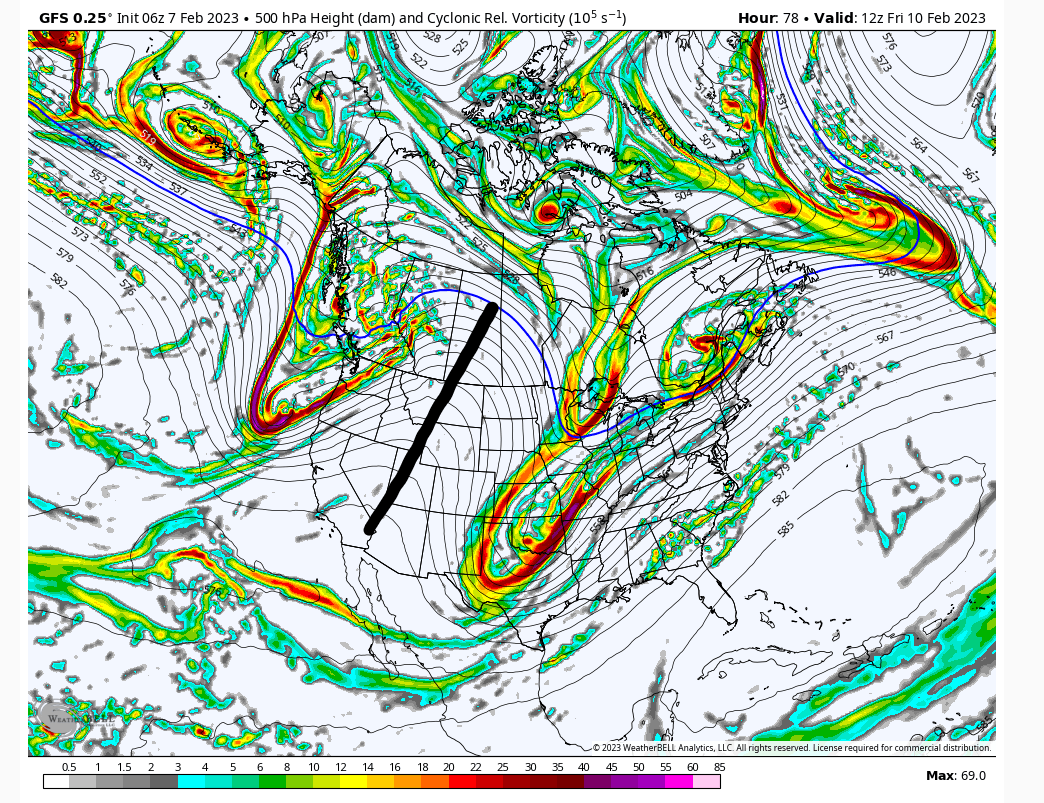
I think we are both looking at the same box, but from slight diff perspectives. There seems to be two aspects to this set up. One is like you said we get Pac energy dropping into the heart land, ie: digging trough, as a result of the ridge. But there is a potent N Pac jet extension that drives energy into the NW quadrant of the ridge completely knocking it down, and causing our energy to cutoff from the mean flow as it approaches the Tennessee valley. It also cuts off energy along the west coast which backs up SW into the Cali/Baha Peninsula area.
Ill add some images shortly to make things clearer. Where a cutoff ULL occurs, and then moves is going to be extremely diff to predict. If it doesnt cutoff, IMHO of course, then it remains tied to the mean trough, and results in no more than a strung out front of vorticity embedded within a very progressive trough and there wont even be a storm.
_________________
"In weather and in life, there's no winning and losing; there's only winning and learning."
WINTER 2012/2013 TOTALS 43.65"WINTER 2017/2018 TOTALS 62.85" WINTER 2022/2023 TOTALS 4.9"
WINTER 2013/2014 TOTALS 64.85"WINTER 2018/2019 TOTALS 14.25" WINTER 2023/2024 TOTALS 13.1"
WINTER 2014/2015 TOTALS 71.20"WINTER 2019/2020 TOTALS 6.35"
WINTER 2015/2016 TOTALS 35.00"WINTER 2020/2021 TOTALS 37.75"
WINTER 2016/2017 TOTALS 42.25"WINTER 2021/2022 TOTALS 31.65"

sroc4- Admin

- Posts : 8331
Reputation : 301
Join date : 2013-01-07
Location : Wading River, LI
heehaw453 likes this post
 Re: Long Range Thread 25.0
This pattern is actually more boring than watching paint dry, but yet the two of you will go back into the room every hour just to watch it to make sure it’s still drying.
Not meant in a negative way, I just find your perseverance admirable. I just wish it would pay off before the end of Wing.

CPcantmeasuresnow- Wx Statistician Guru

- Posts : 7274
Reputation : 230
Join date : 2013-01-07
Age : 103
Location : Eastern Orange County, NY
sroc4 and essexcountypete like this post
 Re: Long Range Thread 25.0
Yep, the fast PAC flow is ubiquitous and count on it every storm threat. IT will push up on the ridge and want to push things forward. Models showing a cutoff ULL today. But it still may get not make the turn up the coast due that force. I agree cutoff ULL has a mind of its own so just have to watch the next day or so. IMO someone gets snow, but is it interior VA or NJ? Take the under this year and you'll do well.sroc4 wrote:heehaw453 wrote:Sroc I'm going to disagree on the digging trough. What the GFS depicts at 06Z is a digging trough. The ULL is able to close off because it's tethered to the n/s and the 50/50 low starts to dampen heights which slows the flow down a tad to help the ULL energy consolidate better. At least that's how I see it. I also see this as a long shot in a terrible winter, but on the other hand if something like this was to work out February is the month I'd expect to see it. GFS could very well go back to nada at 12Z if any of that consolidation is just a bit off.
I think we are both looking at the same box, but from slight diff perspectives. There seems to be two aspects to this set up. One is like you said we get Pac energy dropping into the heart land, ie: digging trough, as a result of the ridge. But there is a potent N Pac jet extension that drives energy into the NW quadrant of the ridge completely knocking it down, and causing our energy to cutoff from the mean flow as it approaches the Tennessee valley. It also cuts off energy along the west coast which backs up SW into the Cali/Baha Peninsula area.
Ill add some images shortly to make things clearer. Where a cutoff ULL occurs, and then moves is going to be extremely diff to predict. If it doesnt cutoff, IMHO of course, then it remains tied to the mean trough, and results in no more than a strung out front of vorticity embedded within a very progressive trough and there wont even be a storm.
heehaw453- Advanced Forecaster

- Posts : 3906
Reputation : 86
Join date : 2014-01-20
Location : Bedminster Township, PA Elevation 600' ASL
sroc4 likes this post
 Re: Long Range Thread 25.0
expectations are record breaking futility. Very hard to stop a moving train in time. nonetheless the occasional Hail Mary pass grabs my attention even though I know it's almost always going to hit the ground...CPcantmeasuresnow wrote:I really admire the both of you (Sroc and Heehaw).
This pattern is actually more boring than watching paint dry, but yet the two of you will go back into the room every hour just to watch it to make sure it’s still drying.
Not meant in a negative way, I just find your perseverance admirable. I just wish it would pay off before the end of Wing.
heehaw453- Advanced Forecaster

- Posts : 3906
Reputation : 86
Join date : 2014-01-20
Location : Bedminster Township, PA Elevation 600' ASL
CPcantmeasuresnow likes this post
 Re: Long Range Thread 25.0

.png.62403beb1f05d887b61d5e382560daf5.png)
Energy more consolidated and robust and digging a bit more as well
_________________
Mugs
AKA:King: Snow Weenie
Self Proclaimed
WINTER 2014-15 : 55.12" +.02 for 6 coatings (avg. 35")
WINTER 2015-16 Total - 29.8" (Avg 35")
WINTER 2016-17 : 39.5" so far

amugs- Advanced Forecaster - Mod

- Posts : 15093
Reputation : 213
Join date : 2013-01-07
Age : 54
Location : Hillsdale,NJ
sroc4 likes this post
 Re: Long Range Thread 25.0
CPcantmeasuresnow wrote:I really admire the both of you (Sroc and Heehaw).
This pattern is actually more boring than watching paint dry, but yet the two of you will go back into the room every hour just to watch it to make sure it’s still drying.
Not meant in a negative way, I just find your perseverance admirable. I just wish it would pay off before the end of Wing.
They both are admirable, but I think we are getting close to the time that it is similar to rearranging deck chairs on the Titanic.In a normal Wall, I would be optimistic for late Feb. through March, but this God awful season makes one abandon all hope.I will stay on 25% optimistic hoping something will thread the needle because it is a long stretch until Nov when we can get accumulating snow.

docstox12- Wx Statistician Guru

- Posts : 8504
Reputation : 222
Join date : 2013-01-07
Age : 73
Location : Monroe NY
sroc4, dkodgis and heehaw453 like this post
 Re: Long Range Thread 25.0

dkodgis- Senior Enthusiast

- Posts : 2498
Reputation : 98
Join date : 2013-12-29
docstox12 likes this post
 Re: Long Range Thread 25.0
amugs wrote:Nice lesn on the Euro EPS westward and makes a sizeable shift NW with the synoptic set up. Keep expectations in check and we'll see where this goes.
Energy more consolidated and robust and digging a bit more as well
Expectations in check? Mugs they couldn’t be any lower, if it’s anything below 50° and sunny on Saturday I’ll consider the win.

CPcantmeasuresnow- Wx Statistician Guru

- Posts : 7274
Reputation : 230
Join date : 2013-01-07
Age : 103
Location : Eastern Orange County, NY
docstox12, essexcountypete and heehaw453 like this post
 Re: Long Range Thread 25.0
It is raining here right now. It is 37 degrees. Thurs it will rain and be about 45 degrees.
Never cold enough when it rains. Rain, rain, rain. Moss, moss, moss.

dkodgis- Senior Enthusiast

- Posts : 2498
Reputation : 98
Join date : 2013-12-29
 Re: Long Range Thread 25.0
SENJsnowman- Senior Enthusiast

- Posts : 1186
Reputation : 61
Join date : 2017-01-06
Age : 51
Location : Bayville, NJ
heehaw453 likes this post
 Re: Long Range Thread 25.0
So true... It does seem like that so often. This one is way too precarious to rule anyone out ATTM. Temps are an issue for anyone in our area as the antecedent air mass isn't ideal. Just depends on how much dynamic cooling can occur.SENJsnowman wrote:Typically the first part of tracking any ‘threats’ this season has been to proclaim the Jersey coast has already been expressly eliminated from any potential snow fall. I could be wrong, but I don’t think that’s happened yet with this one. I’m assuming it’s just an oversight, but if any of our Mets want to go ahead and make it official…
heehaw453- Advanced Forecaster

- Posts : 3906
Reputation : 86
Join date : 2014-01-20
Location : Bedminster Township, PA Elevation 600' ASL
 Re: Long Range Thread 25.0

billg315- Advanced Forecaster - Mod

- Posts : 4466
Reputation : 185
Join date : 2015-01-24
Age : 50
Location : Flemington, NJ
CPcantmeasuresnow likes this post
 Re: Long Range Thread 25.0
billg315 wrote:Looking at temperature projections for the 14 day period they look like two weeks in late March. Someone said last week (heehaw maybe?) that they doubt Feb will match January’s +10AN temps. Looking at the next two weeks, I’m not so sure. Lol.
If you look at how the MJO forecast is unfolding it's no question as to why this is. In Feb you cannot run these MJO phases(3-4-5-6) with any kind of amplitude without it being AN to well AN temp wise in the east; combine this with our background La Nina state of course.
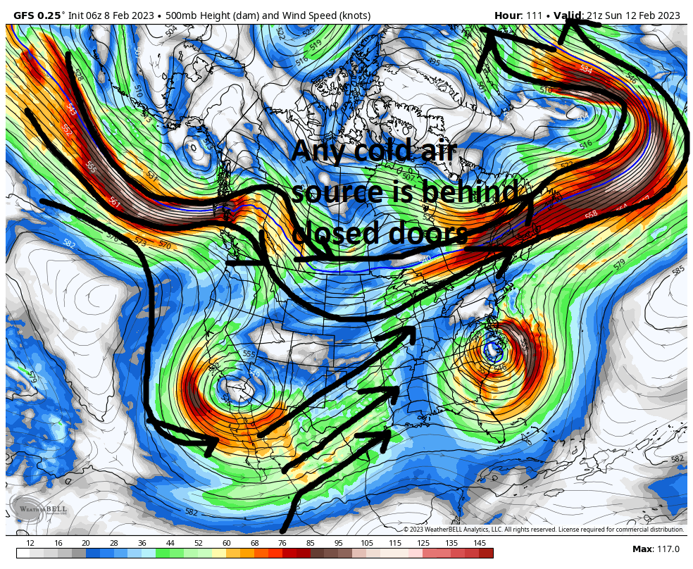
Unfortunately I am pretty confident that our "threat " for this weekend is going to fall victim to these big picture items. All three major models, GFS, CMC, and Euro have our energy dip into the heart land compliments of a WC ridge. At first glance this all starts off great.


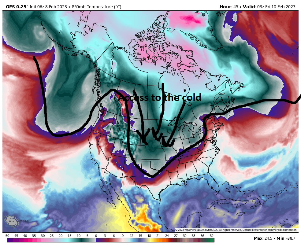
As it does so a potent N Pac jet extension attacks the NW flank of the ridge resulting in the northern half of the ridge "rolling over" from west to east in S Canada. This results in the energy that is our system as well as a second batch of energy along the WC to cutt off from the mean flow of the polar jet stream. This effectively cuts the CONUS off from the polar air mass from the beginning off the west coast; to all the way across the northern tear of country through the northern Atlantic.
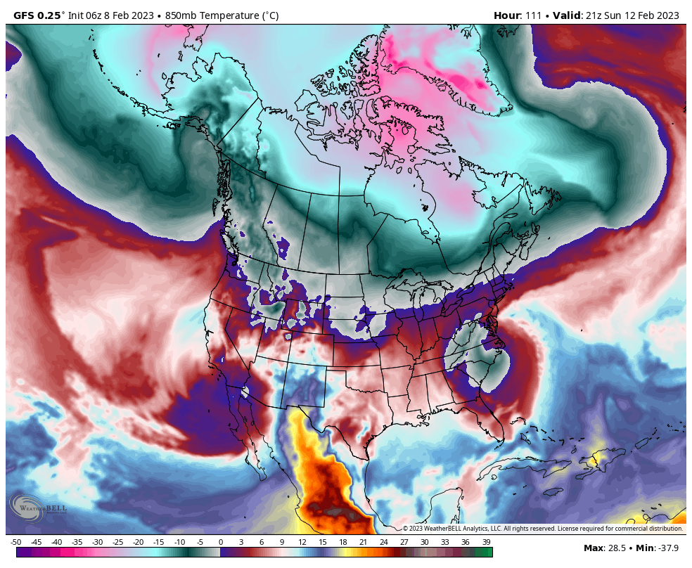
This MJO/La Nina combo is locking the door to any cold air source. Plain and simple. The only air mass our system has to draw from is Pac or subtropical to draw from as it reaches the coast. It has to generate its own cold air meaning it has to be potent enough to draw cold air "down" from the upper levels via the nature of its vortex. (Think of it like a whirl pool of wind. Your boat starts on the edges of the whirl pool and as it goes round and round and gets drawn into the center is lowers in height of the vortex. This i what is needed to draw the cold air down to work this weekend.)
I'm afraid that even with the perfect track this weekend this system will fail most if not all of us.


_________________
"In weather and in life, there's no winning and losing; there's only winning and learning."
WINTER 2012/2013 TOTALS 43.65"WINTER 2017/2018 TOTALS 62.85" WINTER 2022/2023 TOTALS 4.9"
WINTER 2013/2014 TOTALS 64.85"WINTER 2018/2019 TOTALS 14.25" WINTER 2023/2024 TOTALS 13.1"
WINTER 2014/2015 TOTALS 71.20"WINTER 2019/2020 TOTALS 6.35"
WINTER 2015/2016 TOTALS 35.00"WINTER 2020/2021 TOTALS 37.75"
WINTER 2016/2017 TOTALS 42.25"WINTER 2021/2022 TOTALS 31.65"

sroc4- Admin

- Posts : 8331
Reputation : 301
Join date : 2013-01-07
Location : Wading River, LI
 Re: Long Range Thread 25.0

heehaw453- Advanced Forecaster

- Posts : 3906
Reputation : 86
Join date : 2014-01-20
Location : Bedminster Township, PA Elevation 600' ASL
 Re: Long Range Thread 25.0
February normal in CPK 35.9. Currently after 1 week it's running -2.3 BN. We're not going +10 this month and this day was the nail in the coffin. Now not say we won't be well AN like a +4, but that's par for the course in winter around here.billg315 wrote:Looking at temperature projections for the 14 day period they look like two weeks in late March. Someone said last week (heehaw maybe?) that they doubt Feb will match January’s +10AN temps. Looking at the next two weeks, I’m not so sure. Lol.
| 2023-02-04 | 27 | 3 | 15.0 | -19.0 |
heehaw453- Advanced Forecaster

- Posts : 3906
Reputation : 86
Join date : 2014-01-20
Location : Bedminster Township, PA Elevation 600' ASL
 Re: Long Range Thread 25.0
Winter cancel. Maybe March delivers a surprise.
_________________
_______________________________________________________________________________________________________
CLICK HERE to view NJ Strong Snowstorm Classifications
CPcantmeasuresnow likes this post
 Re: Long Range Thread 25.0
MattyICE- Advanced Forecaster

- Posts : 249
Reputation : 6
Join date : 2017-11-10
Age : 38
Location : Clifton, NJ (Eastern Passaic County)
docstox12, CPcantmeasuresnow, kalleg, weatherwatchermom, billg315 and SENJsnowman like this post
Page 33 of 40 •  1 ... 18 ... 32, 33, 34 ... 36 ... 40
|
|
|

 Home
Home


