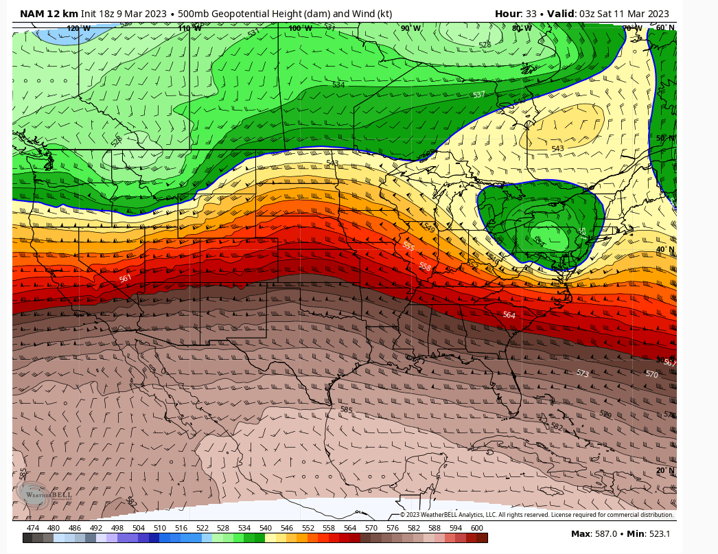
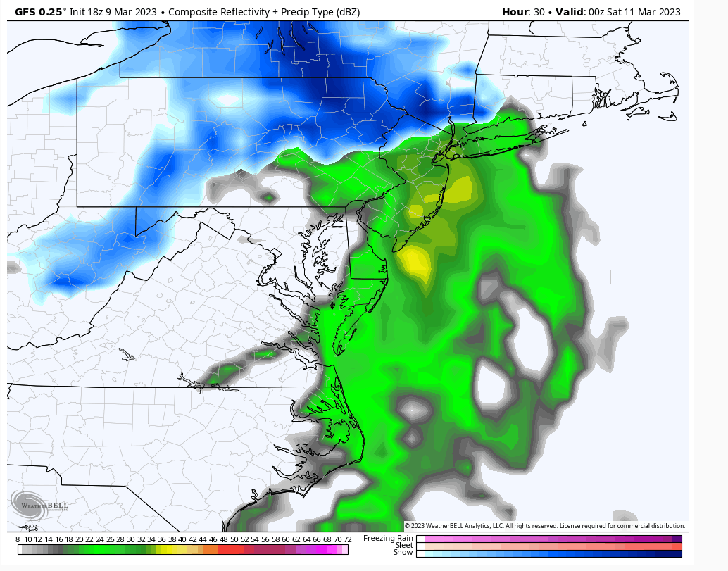
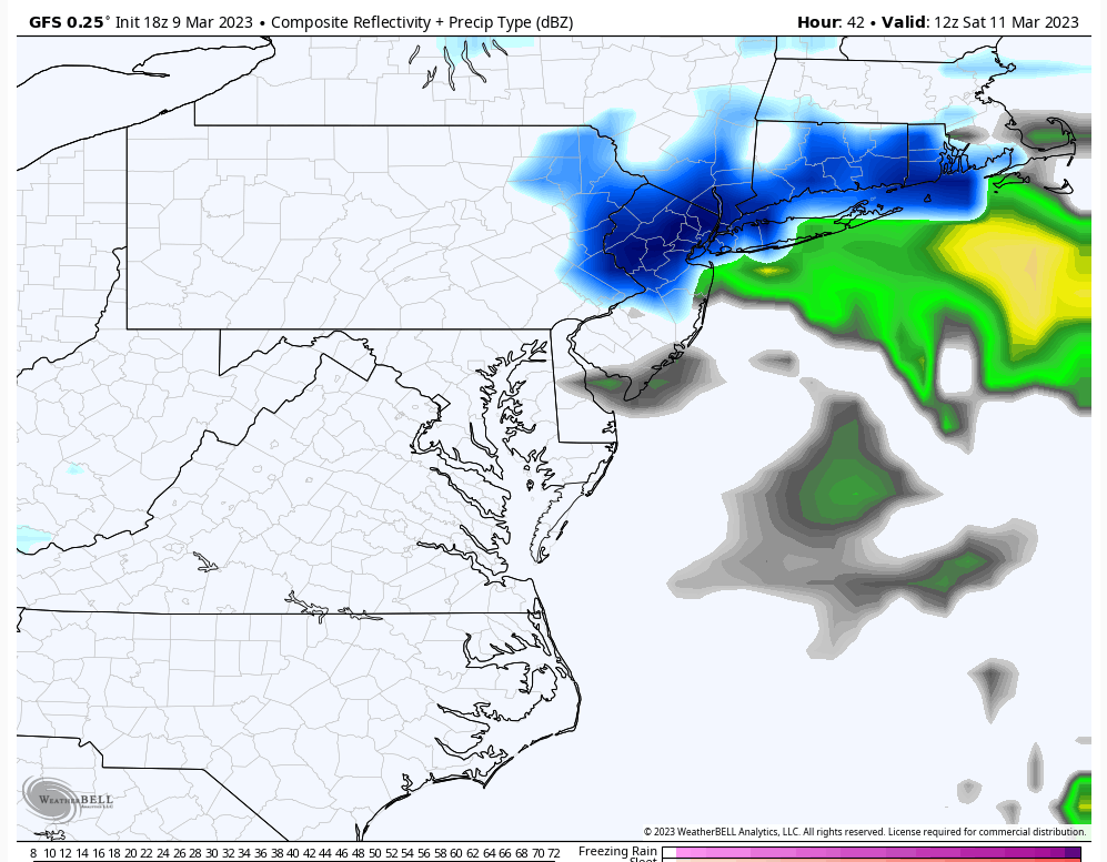
Friday-Saturday Light Snowfall
Page 1 of 4 • 1, 2, 3, 4 
 Friday-Saturday Light Snowfall
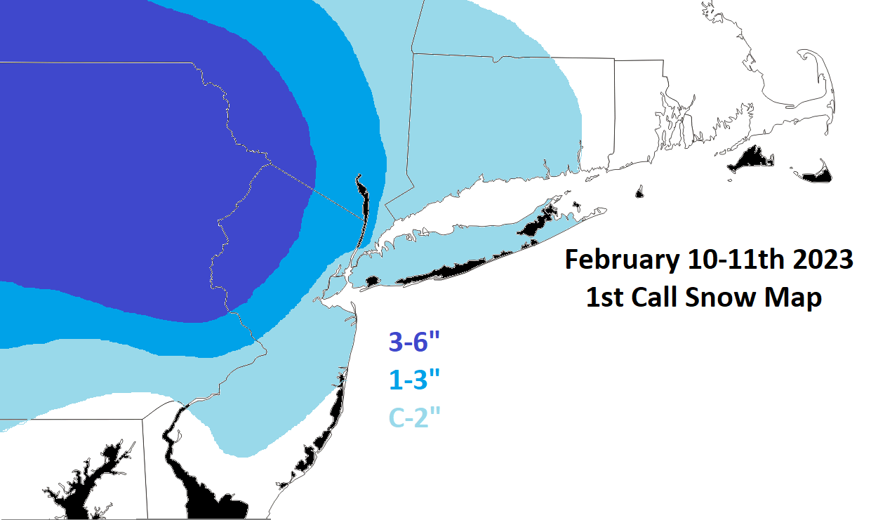
Still concerned about surface temps along immediate coast down the Jersey Shore, but I think N&W is going to net a few inches from this. Hey, back to back snows in March. Maybe this winter gets upgraded from an F to a D-?
_________________
_______________________________________________________________________________________________________
CLICK HERE to view NJ Strong Snowstorm Classifications
kalleg, essexcountypete, 1190ftalt, heehaw453, SENJsnowman and JT33 like this post
 Re: Friday-Saturday Light Snowfall
Only way this winter goes from an F to a D-, Is if we get at least one Godzilla type storm or better.Frank_Wx wrote:The upper level energy associated with this event is fairly weak. I think we're looking at an even lighter snowfall than what we just saw a couple of days ago. Here's my 1st call snow map. Let's use this thread to discuss this one, and LR to analyze Monday's possible biggy.
Still concerned about surface temps along immediate coast down the Jersey Shore, but I think N&W is going to net a few inches from this. Hey, back to back snows in March. Maybe this winter gets upgraded from an F to a D-?
That is how awful this winter has been sadly.
dolphins222- Posts : 26
Reputation : 0
Join date : 2013-10-04
CPcantmeasuresnow likes this post
 Re: Friday-Saturday Light Snowfall
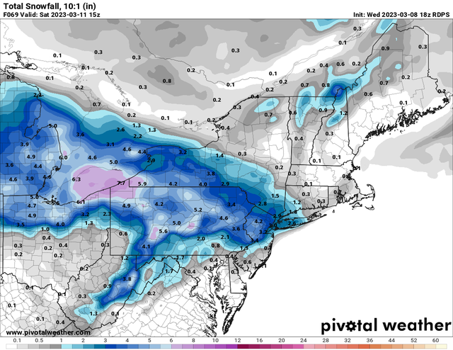
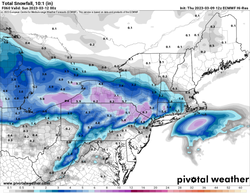
18Z EURO
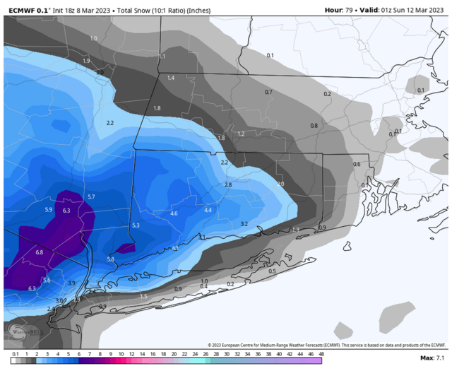
Where do I sign!!
_________________
Mugs
AKA:King: Snow Weenie
Self Proclaimed
WINTER 2014-15 : 55.12" +.02 for 6 coatings (avg. 35")
WINTER 2015-16 Total - 29.8" (Avg 35")
WINTER 2016-17 : 39.5" so far

amugs- Advanced Forecaster - Mod

- Posts : 15095
Reputation : 213
Join date : 2013-01-07
Age : 54
Location : Hillsdale,NJ
 Re: Friday-Saturday Light Snowfall

_________________
Mugs
AKA:King: Snow Weenie
Self Proclaimed
WINTER 2014-15 : 55.12" +.02 for 6 coatings (avg. 35")
WINTER 2015-16 Total - 29.8" (Avg 35")
WINTER 2016-17 : 39.5" so far

amugs- Advanced Forecaster - Mod

- Posts : 15095
Reputation : 213
Join date : 2013-01-07
Age : 54
Location : Hillsdale,NJ
 Re: Friday-Saturday Light Snowfall
WINTER WEATHER ADVISORY IN EFFECT FROM 1 PM FRIDAY TO 10 AMEST SATURDAY...
* WHAT...Snow expected. Total snow accumulations of 2 to 4 inches.
* WHERE...Portions of northern and northwest New Jersey and east central Pennsylvania.
* WHEN...From 1 PM Friday to 10 AM EST Saturday.
* IMPACTS...Plan on slippery road conditions. The hazardous conditions could impact the evening commute. PRECAUTIONARY/PREPAREDNESS ACTIONS... Slow down and use caution while traveling. The latest road conditions for the state you are calling from can be obtained by calling 5 1 1. &

billg315- Advanced Forecaster - Mod

- Posts : 4483
Reputation : 185
Join date : 2015-01-24
Age : 50
Location : Flemington, NJ
weatherwatchermom likes this post
 Re: Friday-Saturday Light Snowfall

billg315- Advanced Forecaster - Mod

- Posts : 4483
Reputation : 185
Join date : 2015-01-24
Age : 50
Location : Flemington, NJ
1190ftalt, weatherwatchermom and SENJsnowman like this post
 Re: Friday-Saturday Light Snowfall
These types of events can be very localized, so wouldn't be unusual for areas north and south to get very little accumulation, but the area in between to get dumped on for a few hours.

billg315- Advanced Forecaster - Mod

- Posts : 4483
Reputation : 185
Join date : 2015-01-24
Age : 50
Location : Flemington, NJ
Frank_Wx, kalleg, 1190ftalt and weatherwatchermom like this post
 Re: Friday-Saturday Light Snowfall

billg315- Advanced Forecaster - Mod

- Posts : 4483
Reputation : 185
Join date : 2015-01-24
Age : 50
Location : Flemington, NJ

CNWestMilford- Posts : 43
Reputation : 1
Join date : 2020-12-15
Age : 47
Location : West Milford
heehaw453- Advanced Forecaster

- Posts : 3906
Reputation : 86
Join date : 2014-01-20
Location : Bedminster Township, PA Elevation 600' ASL
1190ftalt, billg315 and CNWestMilford like this post
 Re: Friday-Saturday Light Snowfall
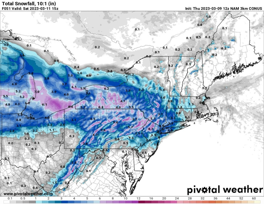
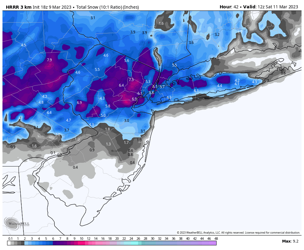
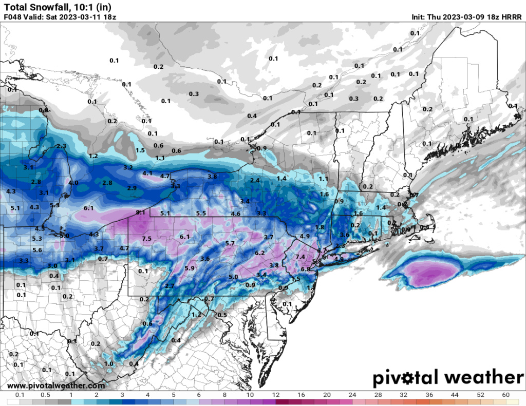
billg315 wrote:So an interesting feature on the 12z NAM is what looks like sort of a Norlun trough type situation where an area of snow extends back to the coast as the low intensifies offshore. The NAM actually shows a heavy burst of snow at the NJ coast in the Monmouth and Ocean County areas producing a few inches of snow there. The GFS and Euro hint at this also, but don't show the same accumulations. Real, or not real? Trying to figure that out as it could create an "island" of accumulation near the NJ coast at the tail end of this if accurate verbatim.
Forms a Meso Low just off the coast - reminds me of Nov 2017 storm that did the same and dumped on the NNJ region for hours bringing the area to halt that rush hour and night
_________________
Mugs
AKA:King: Snow Weenie
Self Proclaimed
WINTER 2014-15 : 55.12" +.02 for 6 coatings (avg. 35")
WINTER 2015-16 Total - 29.8" (Avg 35")
WINTER 2016-17 : 39.5" so far

amugs- Advanced Forecaster - Mod

- Posts : 15095
Reputation : 213
Join date : 2013-01-07
Age : 54
Location : Hillsdale,NJ
 Re: Friday-Saturday Light Snowfall

NAM 12Z yuo can clearly see where it pops the meso low off Monmouth County. Issue maybe when it happens which is at daybreak for accumulatiosn with a BL of 33/34. IF this was a true arctic air source then it'd be a slam dunk for accumulations. There is alot of energy flying in this system so pin pointing this is going to be basically a nowcast time......at 3-4AM
_________________
Mugs
AKA:King: Snow Weenie
Self Proclaimed
WINTER 2014-15 : 55.12" +.02 for 6 coatings (avg. 35")
WINTER 2015-16 Total - 29.8" (Avg 35")
WINTER 2016-17 : 39.5" so far

amugs- Advanced Forecaster - Mod

- Posts : 15095
Reputation : 213
Join date : 2013-01-07
Age : 54
Location : Hillsdale,NJ
1190ftalt and CNWestMilford like this post
 Re: Friday-Saturday Light Snowfall
amugs wrote:
NAM 12Z yuo can clearly see where it pops the meso low off Monmouth County. Issue maybe when it happens which is at daybreak for accumulatiosn with a BL of 33/34. IF this was a true arctic air source then it'd be a slam dunk for accumulations. There is alot of energy flying in this system so pin pointing this is going to be basically a nowcast time......at 3-4AM
Uh, wow!!
SENJsnowman- Senior Enthusiast

- Posts : 1189
Reputation : 61
Join date : 2017-01-06
Age : 51
Location : Bayville, NJ
 Re: Friday-Saturday Light Snowfall
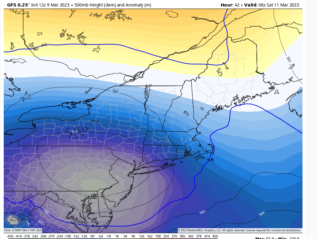
The ULL is coming in further north on the models now. That means to me better chance for snow is the coastal unless you're in extreme NW NJ, NEPA and maybe LHV. Initial WAA snows would be confined to that area if this is a true trend.
edit: I wouldn't trust much right now on the models as ULL that close off are tricky birds.
heehaw453- Advanced Forecaster

- Posts : 3906
Reputation : 86
Join date : 2014-01-20
Location : Bedminster Township, PA Elevation 600' ASL
weatherwatchermom and billg315 like this post
 Re: Friday-Saturday Light Snowfall

jmanley32- Senior Enthusiast

- Posts : 20535
Reputation : 108
Join date : 2013-12-12
Age : 43
Location : Yonkers, NY

CNWestMilford- Posts : 43
Reputation : 1
Join date : 2020-12-15
Age : 47
Location : West Milford
amugs likes this post
 Re: Friday-Saturday Light Snowfall
_________________
Mugs
AKA:King: Snow Weenie
Self Proclaimed
WINTER 2014-15 : 55.12" +.02 for 6 coatings (avg. 35")
WINTER 2015-16 Total - 29.8" (Avg 35")
WINTER 2016-17 : 39.5" so far

amugs- Advanced Forecaster - Mod

- Posts : 15095
Reputation : 213
Join date : 2013-01-07
Age : 54
Location : Hillsdale,NJ
CNWestMilford likes this post

aiannone- Senior Enthusiast - Mod

- Posts : 4815
Reputation : 92
Join date : 2013-01-07
Location : Saint James, LI (Northwest Suffolk Co.)
CNWestMilford likes this post
 Re: Friday-Saturday Light Snowfall
amugs wrote:West Milford you are in a great spot - you'll get smoked up their in dem hills!!
The trends continue to be positive toward the coast.
I think the city will see some accumulation now. A couple of inches?

CNWestMilford- Posts : 43
Reputation : 1
Join date : 2020-12-15
Age : 47
Location : West Milford
heehaw453- Advanced Forecaster

- Posts : 3906
Reputation : 86
Join date : 2014-01-20
Location : Bedminster Township, PA Elevation 600' ASL
JT33 likes this post

CPcantmeasuresnow- Wx Statistician Guru

- Posts : 7274
Reputation : 230
Join date : 2013-01-07
Age : 103
Location : Eastern Orange County, NY
essexcountypete and CNWestMilford like this post

CNWestMilford- Posts : 43
Reputation : 1
Join date : 2020-12-15
Age : 47
Location : West Milford
 Re: Friday-Saturday Light Snowfall
ISSUED: 4:12 PM MAR. 9, 2023 – NATIONAL WEATHER SERVICE
...WINTER WEATHER ADVISORY IN EFFECT FROM 6 PM FRIDAY TO 10 AM
EST SATURDAY...
* WHAT...Snow expected. Total snow accumulations 3 to 6 inches
with locally higher amounts possible well north and west of NYC.
* WHERE...Portions of southern Connecticut, northeast New Jersey
and southeast New York.
* WHEN...From 6 PM Friday to 10 AM EST Saturday.
* IMPACTS...Plan on slippery road conditions. The hazardous
conditions could impact the evening commute.
PRECAUTIONARY/PREPAREDNESS ACTIONS...
Slow down and use caution while traveling.

essexcountypete- Pro Enthusiast

- Posts : 783
Reputation : 12
Join date : 2013-12-09
Location : Bloomfield, NJ
kalleg and heehaw453 like this post
 Re: Friday-Saturday Light Snowfall
If that coastal wraps up faster or just stalls a bit longer you may be closer to the 6". Very dynamic setup and won't take much.essexcountypete wrote:WWA for my area has issued. I was not expecting the 3-6" prediction.
ISSUED: 4:12 PM MAR. 9, 2023 – NATIONAL WEATHER SERVICE
...WINTER WEATHER ADVISORY IN EFFECT FROM 6 PM FRIDAY TO 10 AM
EST SATURDAY...
* WHAT...Snow expected. Total snow accumulations 3 to 6 inches
with locally higher amounts possible well north and west of NYC.
* WHERE...Portions of southern Connecticut, northeast New Jersey
and southeast New York.
* WHEN...From 6 PM Friday to 10 AM EST Saturday.
* IMPACTS...Plan on slippery road conditions. The hazardous
conditions could impact the evening commute.
PRECAUTIONARY/PREPAREDNESS ACTIONS...
Slow down and use caution while traveling.
heehaw453- Advanced Forecaster

- Posts : 3906
Reputation : 86
Join date : 2014-01-20
Location : Bedminster Township, PA Elevation 600' ASL
docstox12, essexcountypete and CNWestMilford like this post
heehaw453- Advanced Forecaster

- Posts : 3906
Reputation : 86
Join date : 2014-01-20
Location : Bedminster Township, PA Elevation 600' ASL
kalleg and CNWestMilford like this post
Page 1 of 4 • 1, 2, 3, 4 
|
|
|

 Home
Home
