
 Search
2023 Atlantic Tropics season
Page 6 of 20 •  1 ... 5, 6, 7 ... 13 ... 20
 ![]()
Re: 2023 Atlantic Tropics season
![]() by dkodgis Tue Sep 05, 2023 2:33 pm
by dkodgis Tue Sep 05, 2023 2:33 pm
dkodgis- Senior Enthusiast

- Posts : 2560
Join date : 2013-12-29
kalleg and jmanley32 like this post
Re: 2023 Atlantic Tropics season
![]() by sroc4 Tue Sep 05, 2023 3:21 pm
by sroc4 Tue Sep 05, 2023 3:21 pm

sroc4- Admin

- Posts : 8354
Join date : 2013-01-07
kalleg, jmanley32 and weatherwatchermom like this post
Re: 2023 Atlantic Tropics season
![]() by jmanley32 Tue Sep 05, 2023 3:49 pm
by jmanley32 Tue Sep 05, 2023 3:49 pm
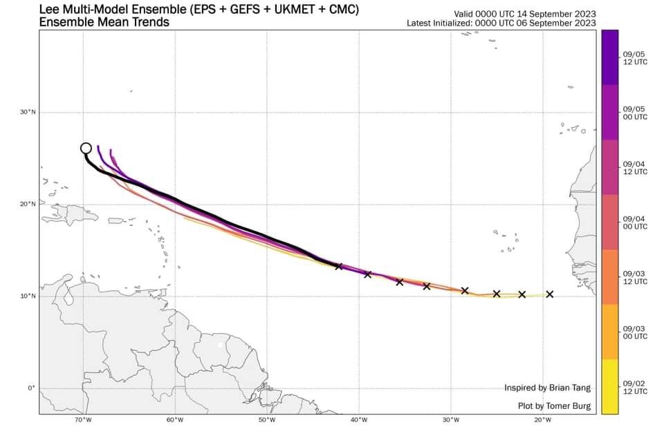
LOL I love the crayola, this is great but true. And your right strong canes have a mind of their own and track will change, I think thats a good timeframe to begin looking at it, also depends on forward speed. Don't stronger hurricanes move slower? Any slowdown would push out the time frame for a threa to the EC.sroc4 wrote:No matter what any run says it’s important to remember in general there is nothing to take serious until the system gets to the Caribbean. I’d say next weekend at the earliest. Even then the devils in the details. Because this system will be very strong it won’t be as straight forward as looking at 500mb to analyze the steering flow. There likely will be vectors playing a role in his movement at the 300-200mb as well. This is the current cone of uncertainty beyond the weekend.

jmanley32- Senior Enthusiast
- Posts : 20535
Reputation : 108
Join date : 2013-12-12
Age : 43
Location : Yonkers, NY
Re: 2023 Atlantic Tropics season
![]() by jmanley32 Tue Sep 05, 2023 3:51 pm
by jmanley32 Tue Sep 05, 2023 3:51 pm
LOL I love the crayola, this is great but true. And your right strong canes have a mind of their own and track will change (we don't even have a defined center yet which wil lchange thigs too), I think that's a good timeframe to begin looking at it closer, also depends on forward speed. Don't stronger hurricanes move slower? Any slowdown would push out the time frame for a threat to the EC. Still interested in it's evolution, will be interesting to see how fast Lee strengthens and to what category, I do not think 5 is out of the question IMO.sroc4 wrote:No matter what any run says it’s important to remember in general there is nothing to take serious until the system gets to the Caribbean. I’d say next weekend at the earliest. Even then the devils in the details. Because this system will be very strong it won’t be as straight forward as looking at 500mb to analyze the steering flow. There likely will be vectors playing a role in his movement at the 300-200mb as well. This is the current cone of uncertainty beyond the weekend.
jmanley32- Senior Enthusiast
- Posts : 20535
Reputation : 108
Join date : 2013-12-12
Age : 43
Location : Yonkers, NY
jmanley32- Senior Enthusiast
- Posts : 20535
Reputation : 108
Join date : 2013-12-12
Age : 43
Location : Yonkers, NY
Re: 2023 Atlantic Tropics season
![]() by jmanley32 Tue Sep 05, 2023 6:24 pm
by jmanley32 Tue Sep 05, 2023 6:24 pm
It is becoming a question of when and not if rapid intensification
(RI) occurs with Lee. A well-defined outflow pattern has developed
over the circulation, and there are some hints on a recent SSMI/S
microwave pass that parts of an inner core are forming. There's
still some notable northeasterly shear that could keep Lee in
check for the next day or two, so the NHC intensity forecast will
stay at a more moderate rate of intensification during that time.
All of the models decrease the shear by Friday, so RI is explicitly
forecast at that time frame while Lee is moving over extremely warm
waters. The new forecast is adjusted higher than the last advisory,
near the model consensus, but there's a notable contingent of
guidance higher than this forecast. There is increasing confidence
on Lee becoming a very powerful hurricane by this weekend.
FORECAST POSITIONS AND MAX WINDS
INIT 05/2100Z 13.2N 41.8W 40 KT 45 MPH
12H 06/0600Z 13.7N 43.7W 50 KT 60 MPH
24H 06/1800Z 14.4N 46.2W 60 KT 70 MPH
36H 07/0600Z 15.2N 48.5W 70 KT 80 MPH
48H 07/1800Z 16.2N 51.0W 80 KT 90 MPH
60H 08/0600Z 17.2N 53.6W 90 KT 105 MPH
72H 08/1800Z 18.3N 56.0W 110 KT 125 MPH
96H 09/1800Z 20.4N 60.5W 120 KT 140 MPH
120H 10/1800Z 22.2N 64.3W 125 KT 145 MPH
jmanley32- Senior Enthusiast
- Posts : 20535
Reputation : 108
Join date : 2013-12-12
Age : 43
Location : Yonkers, NY
Re: 2023 Atlantic Tropics season
![]() by amugs Wed Sep 06, 2023 6:54 am
by amugs Wed Sep 06, 2023 6:54 am
Long way away, but this is very precarious set-up along NE coast for Lee mid-next wk. Where does trough set-to in relation to Upper high? Will there be enough trough to steer east of U.S. I am unsure and euro 8pm next fri looks scary as lee would be drawn toward U.S. pic.twitter.com/yel9eZF5Pj
— Bernie Rayno (@AccuRayno) September 6, 2023
_________________
Mugs
AKA:King: Snow Weenie
Self Proclaimed
WINTER 2014-15 : 55.12" +.02 for 6 coatings (avg. 35")
WINTER 2015-16 Total - 29.8" (Avg 35")
WINTER 2016-17 : 39.5" so far

amugs- Advanced Forecaster - Mod

- Posts : 15095
Reputation : 213
Join date : 2013-01-07
Age : 54
Location : Hillsdale,NJ
Re: 2023 Atlantic Tropics season
![]() by jmanley32 Wed Sep 06, 2023 7:01 am
by jmanley32 Wed Sep 06, 2023 7:01 am
will be a hurricane today maybe even beforw noon. He is not mess around intensifying quickly. As we know they can chsnge at drop of a hat but all sgetti right now show a early recurve. Im surprised rayno posted a map 10 days out. I found this graphic which shows the Euro's precarious turn to the NW but it is just one run, up until now it had been in line with what GFS shows, whos correct? We won't know soon, If Bernie doesn't we sure don't.amugs wrote:Raymond rarely speaks in such vernacular.Long way away, but this is very precarious set-up along NE coast for Lee mid-next wk. Where does trough set-to in relation to Upper high? Will there be enough trough to steer east of U.S. I am unsure and euro 8pm next fri looks scary as lee would be drawn toward U.S. pic.twitter.com/yel9eZF5Pj
— Bernie Rayno (@AccuRayno) September 6, 2023

Last edited by jmanley32 on Wed Sep 06, 2023 7:15 am; edited 1 time in total
jmanley32- Senior Enthusiast
- Posts : 20535
Reputation : 108
Join date : 2013-12-12
Age : 43
Location : Yonkers, NY
Re: 2023 Atlantic Tropics season
![]() by rb924119 Wed Sep 06, 2023 7:14 am
by rb924119 Wed Sep 06, 2023 7:14 am
amugs wrote:Raymond rarely speaks in such vernacular.Long way away, but this is very precarious set-up along NE coast for Lee mid-next wk. Where does trough set-to in relation to Upper high? Will there be enough trough to steer east of U.S. I am unsure and euro 8pm next fri looks scary as lee would be drawn toward U.S. pic.twitter.com/yel9eZF5Pj
— Bernie Rayno (@AccuRayno) September 6, 2023
You beat me to it mugsy - I was going to say that last night’s EURO was……..quite concerning. It looks like the GFS Suite from when I did my preliminary analysis.
rb924119- Meteorologist

- Posts : 6928
Reputation : 194
Join date : 2013-02-06
Age : 32
Location : Greentown, Pa
jmanley32 likes this post
Re: 2023 Atlantic Tropics season
![]() by sroc4 Wed Sep 06, 2023 7:59 am
by sroc4 Wed Sep 06, 2023 7:59 am
jmanley32 wrote:will be a hurricane today maybe even beforw noon. He is not mess around intensifying quickly. As we know they can chsnge at drop of a hat but all sgetti right now show a early recurve. Im surprised rayno posted a map 10 days out. I found this graphic which shows the Euro's precarious turn to the NW but it is just one run, up until now it had been in line with what GFS shows, whos correct? We won't know soon, If Bernie doesn't we sure don't.amugs wrote:Raymond rarely speaks in such vernacular.Long way away, but this is very precarious set-up along NE coast for Lee mid-next wk. Where does trough set-to in relation to Upper high? Will there be enough trough to steer east of U.S. I am unsure and euro 8pm next fri looks scary as lee would be drawn toward U.S. pic.twitter.com/yel9eZF5Pj
— Bernie Rayno (@AccuRayno) September 6, 2023
This doesn't necessarily show a recurve Jon. This shows the turn north compliments of the first longwave trough influence. Remember if this is going to come back to the coast, most likely it turns north, misses the first one, meanders under the mean flow, enhancing the Atlantic Ridge, before being captured by the second one and combined with the Atlantic ridge come more west again before finally kicking out.
IMO what is becoming more and more apparent on models, and why Bernie showed what he did, is the second trough involves a cutoff low feature developing over the eastern third of the CONUS. This is was Ray meant by split trough. No way models will resolve timing, strength, or positioning of a cutoff low this far out. The fact that the Euro a day or two ago wasn't even showing it and recurving OTS, but now is consistently showing it along with other major models tells me that it most likely will be there. Its just a mater of when and where relative to the system. Id say overall chances of indirect impacts or a recurve as a close call is more likely than a direct impact/landfall on the coast, but by no means it is overwhelming likelihood at all. A direct recurve or a direct landfall is 100% still on the table.
_________________
"In weather and in life, there's no winning and losing; there's only winning and learning."
WINTER 2012/2013 TOTALS 43.65"WINTER 2017/2018 TOTALS 62.85" WINTER 2022/2023 TOTALS 4.9"
WINTER 2013/2014 TOTALS 64.85"WINTER 2018/2019 TOTALS 14.25" WINTER 2023/2024 TOTALS 13.1"
WINTER 2014/2015 TOTALS 71.20"WINTER 2019/2020 TOTALS 6.35"
WINTER 2015/2016 TOTALS 35.00"WINTER 2020/2021 TOTALS 37.75"
WINTER 2016/2017 TOTALS 42.25"WINTER 2021/2022 TOTALS 31.65"

sroc4- Admin
- Posts : 8354
Reputation : 302
Join date : 2013-01-07
Location : Wading River, LI
rb924119 likes this post
Re: 2023 Atlantic Tropics season
![]() by rb924119 Wed Sep 06, 2023 8:04 am
by rb924119 Wed Sep 06, 2023 8:04 am
I am not trying to hype this, but only give my honest analysis and opinion. We need to watch this extremely closely, folks. Extremely closely. But I’d be lying if I said that I wasn’t pretty concerned by what I’m seeing. Personally, I’ll go on record and say that I think it’s coming in some form. Do I know the exact track? Of course not. But as of right now, I think that our area will be directly impacted to some extent.
rb924119- Meteorologist
- Posts : 6928
Reputation : 194
Join date : 2013-02-06
Age : 32
Location : Greentown, Pa
Re: 2023 Atlantic Tropics season
![]() by rb924119 Wed Sep 06, 2023 8:11 am
by rb924119 Wed Sep 06, 2023 8:11 am
rb924119- Meteorologist
- Posts : 6928
Reputation : 194
Join date : 2013-02-06
Age : 32
Location : Greentown, Pa
Re: 2023 Atlantic Tropics season
![]() by jmanley32 Wed Sep 06, 2023 8:29 am
by jmanley32 Wed Sep 06, 2023 8:29 am
jmanley32- Senior Enthusiast
- Posts : 20535
Reputation : 108
Join date : 2013-12-12
Age : 43
Location : Yonkers, NY
Re: 2023 Atlantic Tropics season
![]() by sroc4 Wed Sep 06, 2023 8:39 am
by sroc4 Wed Sep 06, 2023 8:39 am
jmanley32 wrote:So is this almost a potential sandy like set up or is it diferrent? The recurve west seems similar. If it happens. Ray and scott keep us poated i have plans that thurs fri sat so hoping i will know by wed to cancel or not.
Not sure exactly what you mean regarding a Sandy type set up. This is a completely different set up. Sandy came straight out of the Carribean due north and then NE before being captured by a frontal boundary and hooking back because of already an established North Atlantic block. This is not the case here at all.
Other than it’s a tropical system that might affect the coast the overall set up is quite different.
_________________
"In weather and in life, there's no winning and losing; there's only winning and learning."
WINTER 2012/2013 TOTALS 43.65"WINTER 2017/2018 TOTALS 62.85" WINTER 2022/2023 TOTALS 4.9"
WINTER 2013/2014 TOTALS 64.85"WINTER 2018/2019 TOTALS 14.25" WINTER 2023/2024 TOTALS 13.1"
WINTER 2014/2015 TOTALS 71.20"WINTER 2019/2020 TOTALS 6.35"
WINTER 2015/2016 TOTALS 35.00"WINTER 2020/2021 TOTALS 37.75"
WINTER 2016/2017 TOTALS 42.25"WINTER 2021/2022 TOTALS 31.65"
sroc4- Admin
- Posts : 8354
Reputation : 302
Join date : 2013-01-07
Location : Wading River, LI
rb924119 and jmanley32 like this post
Re: 2023 Atlantic Tropics season
![]() by jmanley32 Wed Sep 06, 2023 8:48 am
by jmanley32 Wed Sep 06, 2023 8:48 am
The curve to the coast is what I meant, you answered my question, its different. No I did not mean in general of course it did not have the same LR track. And thanks for the analysis above, so might at some point if the Euro holds we see the sgetti start to show more of a NW movement plot after that turn? My guess is until we see that turn we really won't know where he is going, only some idea and once it gets to the caribbian This is all likely too soon to even guess.sroc4 wrote:jmanley32 wrote:So is this almost a potential sandy like set up or is it diferrent? The recurve west seems similar. If it happens. Ray and scott keep us poated i have plans that thurs fri sat so hoping i will know by wed to cancel or not.
Not sure exactly what you mean regarding a Sandy type set up. This is a completely different set up. Sandy came straight out of the Carribean due north and then NE before being captured by a frontal boundary and hooking back because of already an established North Atlantic block. This is not the case here at all.
Other than it’s a tropical system that might affect the coast the overall set up is quite different.
jmanley32- Senior Enthusiast
- Posts : 20535
Reputation : 108
Join date : 2013-12-12
Age : 43
Location : Yonkers, NY
Re: 2023 Atlantic Tropics season
![]() by sroc4 Wed Sep 06, 2023 9:05 am
by sroc4 Wed Sep 06, 2023 9:05 am
jmanley32 wrote:The curve to the coast is what I meant, you answered my question, its different. No I did not mean in general of course it did not have the same LR track. And thanks for the analysis above, so might at some point if the Euro holds we see the sgetti start to show more of a NW movement plot after that turn? My guess is until we see that turn we really won't know where he is going, only some idea and once it gets to the caribbian This is all likely too soon to even guess.sroc4 wrote:jmanley32 wrote:So is this almost a potential sandy like set up or is it diferrent? The recurve west seems similar. If it happens. Ray and scott keep us poated i have plans that thurs fri sat so hoping i will know by wed to cancel or not.
Not sure exactly what you mean regarding a Sandy type set up. This is a completely different set up. Sandy came straight out of the Carribean due north and then NE before being captured by a frontal boundary and hooking back because of already an established North Atlantic block. This is not the case here at all.
Other than it’s a tropical system that might affect the coast the overall set up is quite different.
Don’t get excited. There is still soooo much that has to happen. How far north or south is he when he gets to the Lesser and Greater Antilles. What does the Pacific look like At that time.
_________________
"In weather and in life, there's no winning and losing; there's only winning and learning."
WINTER 2012/2013 TOTALS 43.65"WINTER 2017/2018 TOTALS 62.85" WINTER 2022/2023 TOTALS 4.9"
WINTER 2013/2014 TOTALS 64.85"WINTER 2018/2019 TOTALS 14.25" WINTER 2023/2024 TOTALS 13.1"
WINTER 2014/2015 TOTALS 71.20"WINTER 2019/2020 TOTALS 6.35"
WINTER 2015/2016 TOTALS 35.00"WINTER 2020/2021 TOTALS 37.75"
WINTER 2016/2017 TOTALS 42.25"WINTER 2021/2022 TOTALS 31.65"
sroc4- Admin
- Posts : 8354
Reputation : 302
Join date : 2013-01-07
Location : Wading River, LI
Re: 2023 Atlantic Tropics season
![]() by jmanley32 Wed Sep 06, 2023 9:36 am
by jmanley32 Wed Sep 06, 2023 9:36 am
I know, don't worry scott holding in check. I still enjoy the track and watching this beast evolve regardless of where he goes. How can you all be so sure that cut-off low will be there in some way shape or form this far out? Is that something that can be modeled better 10 days out versus the other things like pacific, steering, intensity etc? I understand you said we don't know what it will look like at that exact time which makes sense. Taking bets that this is a cat 3 well before what the NHC shows, Look at how impressive he looks already. Would not be surprised if a hurricane at next update.sroc4 wrote:jmanley32 wrote:The curve to the coast is what I meant, you answered my question, its different. No I did not mean in general of course it did not have the same LR track. And thanks for the analysis above, so might at some point if the Euro holds we see the sgetti start to show more of a NW movement plot after that turn? My guess is until we see that turn we really won't know where he is going, only some idea and once it gets to the caribbian This is all likely too soon to even guess.sroc4 wrote:jmanley32 wrote:So is this almost a potential sandy like set up or is it diferrent? The recurve west seems similar. If it happens. Ray and scott keep us poated i have plans that thurs fri sat so hoping i will know by wed to cancel or not.
Not sure exactly what you mean regarding a Sandy type set up. This is a completely different set up. Sandy came straight out of the Carribean due north and then NE before being captured by a frontal boundary and hooking back because of already an established North Atlantic block. This is not the case here at all.
Other than it’s a tropical system that might affect the coast the overall set up is quite different.
Don’t get excited. There is still soooo much that has to happen. How far north or south is he when he gets to the Lesser and Greater Antilles. What does the Pacific look like At that time.
jmanley32- Senior Enthusiast
- Posts : 20535
Reputation : 108
Join date : 2013-12-12
Age : 43
Location : Yonkers, NY
Re: 2023 Atlantic Tropics season
![]() by rb924119 Wed Sep 06, 2023 9:47 am
by rb924119 Wed Sep 06, 2023 9:47 am
Jon: “ok, I’m not getting excited.”
Five minutes later…
Jon asks multiple questions in quick succession, with a clearly excited tone in the text
Jon, we love you haha

We know that there’s going to be some kind of trough over the east-central U.S. for two reasons, in order of priority:
1. It fits the large-scale pattern drivers (pattern recognition/analoging)
2. The models all agree on the high-level general pattern and its evolution. The details are different from model to model and run to run, but the general theme is common among all of them. Unfortunately, it’s these same unresolved details that will make all the difference in the track.
rb924119- Meteorologist
- Posts : 6928
Reputation : 194
Join date : 2013-02-06
Age : 32
Location : Greentown, Pa
amugs likes this post
Re: 2023 Atlantic Tropics season
![]() by jmanley32 Wed Sep 06, 2023 9:55 am
by jmanley32 Wed Sep 06, 2023 9:55 am
Thanks for that concise understandable explanation.rb924119 wrote:Scott: “Jon, don’t get excited. There’s a lot that isn’t certain yet.”
Jon: “ok, I’m not getting excited.”
Five minutes later…
Jon asks multiple questions in quick succession, with a clearly excited tone in the text
Jon, we love you haha
We know that there’s going to be some kind of trough over the east-central U.S. for two reasons, in order of priority:
1. It fits the large-scale pattern drivers (pattern recognition/analoging)
2. The models all agree on the high-level general pattern and its evolution. The details are different from model to model and run to run, but the general theme is common among all of them. Unfortunately, it’s these same unresolved details that will make all the difference in the track.
A tone in the text, thats' gotten me and my friends into more trouble than not is trying to assess tone in writing (especially with the wife, lol). I am excited in the sense we have something serious to track which isn't a cut and dry "no point in naming this as its going right back out to sea 100%". Could it, yes we already made that clear, but there are also other possibilities. But your concern Ray is noted and taken seriously, and no I will not hold you accountable if you are completely wrong either way and a strong high 5 if you are right, though that would not be a "good" thing per se. I completely understand that this has so many things to work out we cannot make any implications other than in several days it will be somewhere in the carribean. One thing I did read that he will hit cooler waters where Franklin was as he heads north which would weaken him quicker than usual, so won't be as strong if he does threaten the EC. Is that true? I know in general the waters are cooler but did Franklin cool it even more? Hey questions are the only way you get answers right?
jmanley32- Senior Enthusiast
- Posts : 20535
Reputation : 108
Join date : 2013-12-12
Age : 43
Location : Yonkers, NY
sroc4, kalleg and rb924119 like this post
Re: 2023 Atlantic Tropics season
![]() by sroc4 Wed Sep 06, 2023 10:08 am
by sroc4 Wed Sep 06, 2023 10:08 am
jmanley32 wrote:I know, don't worry scott holding in check. I still enjoy the track and watching this beast evolve regardless of where he goes. How can you all be so sure that cut-off low will be there in some way shape or form this far out? Is that something that can be modeled better 10 days out versus the other things like pacific, steering, intensity etc? I understand you said we don't know what it will look like at that exact time which makes sense. Taking bets that this is a cat 3 well before what the NHC shows, Look at how impressive he looks already. Would not be surprised if a hurricane at next update.sroc4 wrote:jmanley32 wrote:The curve to the coast is what I meant, you answered my question, its different. No I did not mean in general of course it did not have the same LR track. And thanks for the analysis above, so might at some point if the Euro holds we see the sgetti start to show more of a NW movement plot after that turn? My guess is until we see that turn we really won't know where he is going, only some idea and once it gets to the caribbian This is all likely too soon to even guess.sroc4 wrote:jmanley32 wrote:So is this almost a potential sandy like set up or is it diferrent? The recurve west seems similar. If it happens. Ray and scott keep us poated i have plans that thurs fri sat so hoping i will know by wed to cancel or not.
Not sure exactly what you mean regarding a Sandy type set up. This is a completely different set up. Sandy came straight out of the Carribean due north and then NE before being captured by a frontal boundary and hooking back because of already an established North Atlantic block. This is not the case here at all.
Other than it’s a tropical system that might affect the coast the overall set up is quite different.
Don’t get excited. There is still soooo much that has to happen. How far north or south is he when he gets to the Lesser and Greater Antilles. What does the Pacific look like At that time.
Specifically answering the Bold and underlined question above Jon....I'm not 100% sure. But see Ray's explanation above. The big picture drivers in place it makes sense that it will be there at some point. Question is is is it there and in a position relative to the timing and position of Lee such that it exerts any meaningful events to Lee that are pertantnt to the populatrion that lives along the EC.
Here is the Euro at initiation earlier this am. Notice the ULL S of Nova Scotia. Look to the west over the northern plains....the next trough.
The next image below is two days from now. The ULL to the NE is being picked up and moving out in the mean flow and the next trough shifts west along the coast. A small piece of it cuts off as you can see around Northern Georgia.
This pattern, with the exception of this week of very Hot Hazy and Humid, has been the theme all summer. Why you ask??? See below. For this reason, along with the major models consistently across the board showing it in one fashion or another, has me fairly certain it will be there. The real question is where is Lee when it does develop?

_________________
"In weather and in life, there's no winning and losing; there's only winning and learning."
WINTER 2012/2013 TOTALS 43.65"WINTER 2017/2018 TOTALS 62.85" WINTER 2022/2023 TOTALS 4.9"
WINTER 2013/2014 TOTALS 64.85"WINTER 2018/2019 TOTALS 14.25" WINTER 2023/2024 TOTALS 13.1"
WINTER 2014/2015 TOTALS 71.20"WINTER 2019/2020 TOTALS 6.35"
WINTER 2015/2016 TOTALS 35.00"WINTER 2020/2021 TOTALS 37.75"
WINTER 2016/2017 TOTALS 42.25"WINTER 2021/2022 TOTALS 31.65"
sroc4- Admin
- Posts : 8354
Reputation : 302
Join date : 2013-01-07
Location : Wading River, LI
rb924119 likes this post
Re: 2023 Atlantic Tropics season
![]() by rb924119 Wed Sep 06, 2023 10:09 am
by rb924119 Wed Sep 06, 2023 10:09 am
As Scott said, there’s plenty of time for things to change, and for my assessment to change. We are still ten days out lol but I’m just relaying my thoughts as the situation evolves, and I’ll readjust if I think I have to. Plus, I’m just one person with one opinion haha I don’t know the future.
rb924119- Meteorologist
- Posts : 6928
Reputation : 194
Join date : 2013-02-06
Age : 32
Location : Greentown, Pa
kalleg and weatherwatchermom like this post
Re: 2023 Atlantic Tropics season
![]() by rb924119 Wed Sep 06, 2023 10:17 am
by rb924119 Wed Sep 06, 2023 10:17 am
jmanley32 wrote:Thanks for that concise understandable explanation.rb924119 wrote:Scott: “Jon, don’t get excited. There’s a lot that isn’t certain yet.”
Jon: “ok, I’m not getting excited.”
Five minutes later…
Jon asks multiple questions in quick succession, with a clearly excited tone in the text
Jon, we love you haha
We know that there’s going to be some kind of trough over the east-central U.S. for two reasons, in order of priority:
1. It fits the large-scale pattern drivers (pattern recognition/analoging)
2. The models all agree on the high-level general pattern and its evolution. The details are different from model to model and run to run, but the general theme is common among all of them. Unfortunately, it’s these same unresolved details that will make all the difference in the track.
A tone in the text, thats' gotten me and my friends into more trouble than not is trying to assess tone in writing (especially with the wife, lol). I am excited in the sense we have something serious to track which isn't a cut and dry "no point in naming this as its going right back out to sea 100%". Could it, yes we already made that clear, but there are also other possibilities. But your concern Ray is noted and taken seriously, and no I will not hold you accountable if you are completely wrong either way and a strong high 5 if you are right, though that would not be a "good" thing per se. I completely understand that this has so many things to work out we cannot make any implications other than in several days it will be somewhere in the carribean. One thing I did read that he will hit cooler waters where Franklin was as he heads north which would weaken him quicker than usual, so won't be as strong if he does threaten the EC. Is that true? I know in general the waters are cooler but did Franklin cool it even more? Hey questions are the only way you get answers right?
My previous message was a partial response to this as well lol if the current tracks are accurate, then yes, Lee would encounter Franklin’s “shadow” of cooler SSTs which could disrupt the intensity a bit. However, my current thinking is that Lee shoots the gap between Franklin’s shadow and the East Coast, which would actually help to maintain intensity for three reasons:
1. Tracks over warmer water
2. Low-level pressure perturbations between the relatively higher pressure associated with the cooler water of Franklin’s shadow and Lee, plus the generally enhanced surface pressures to the north and northeast fed by the stronger Atlantic ridging.
3. Upper-level venting from the trough in question.
rb924119- Meteorologist
- Posts : 6928
Reputation : 194
Join date : 2013-02-06
Age : 32
Location : Greentown, Pa
Re: 2023 Atlantic Tropics season
![]() by sroc4 Wed Sep 06, 2023 10:19 am
by sroc4 Wed Sep 06, 2023 10:19 am
jmanley32 wrote:Thanks for that concise understandable explanation.rb924119 wrote:Scott: “Jon, don’t get excited. There’s a lot that isn’t certain yet.”
Jon: “ok, I’m not getting excited.”
Five minutes later…
Jon asks multiple questions in quick succession, with a clearly excited tone in the text
Jon, we love you haha
We know that there’s going to be some kind of trough over the east-central U.S. for two reasons, in order of priority:
1. It fits the large-scale pattern drivers (pattern recognition/analoging)
2. The models all agree on the high-level general pattern and its evolution. The details are different from model to model and run to run, but the general theme is common among all of them. Unfortunately, it’s these same unresolved details that will make all the difference in the track.
A tone in the text, thats' gotten me and my friends into more trouble than not is trying to assess tone in writing (especially with the wife, lol). I am excited in the sense we have something serious to track which isn't a cut and dry "no point in naming this as its going right back out to sea 100%". Could it, yes we already made that clear, but there are also other possibilities. But your concern Ray is noted and taken seriously, and no I will not hold you accountable if you are completely wrong either way and a strong high 5 if you are right, though that would not be a "good" thing per se. I completely understand that this has so many things to work out we cannot make any implications other than in several days it will be somewhere in the carribean. One thing I did read that he will hit cooler waters where Franklin was as he heads north which would weaken him quicker than usual, so won't be as strong if he does threaten the EC. Is that true? I know in general the waters are cooler but did Franklin cool it even more? Hey questions are the only way you get answers right?
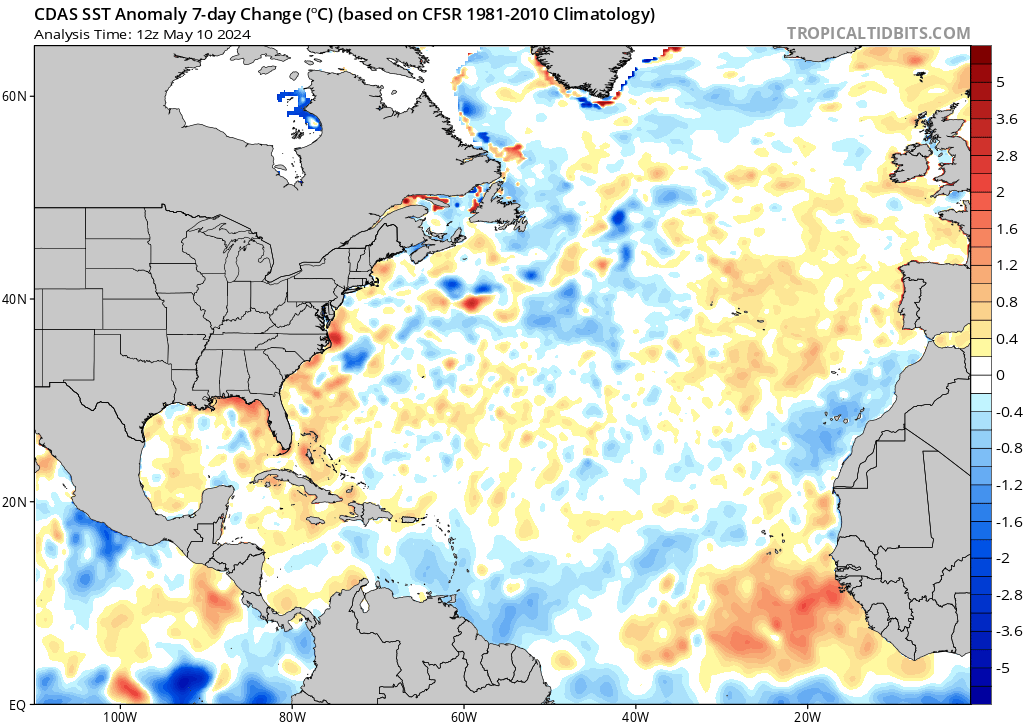
Valid points regarding SSTemps Jon. Even if it reaches Cat 5 at some point the odds of it being that strong at landfall north of the Cap are slim to non...IF it were to make landfall. Here are three images. First is the last 7day change in SSTA. Clearly cooling has been taking place as a result of Franklin AND Idalia coming off he EC churning things up. Second image are current SSTA. Again clearly see is the cooler than normal compliments of the two storms aforementioned. And third image are actual SSTemps. You can see SST go from roughly 80* F to 70* F pretty quickly.


Depending on how slow or fast its moving and at what Latitude how slow or fast it weakens on approach will vary. Does it interact with a front as it approaches transitioning from warm core to cold core which could inject energy back into the system ala Sandy, despite the cooler waters further N. Whats the upper level jet streak doing to the north?? Etc..Etc..So many things
_________________
"In weather and in life, there's no winning and losing; there's only winning and learning."
WINTER 2012/2013 TOTALS 43.65"WINTER 2017/2018 TOTALS 62.85" WINTER 2022/2023 TOTALS 4.9"
WINTER 2013/2014 TOTALS 64.85"WINTER 2018/2019 TOTALS 14.25" WINTER 2023/2024 TOTALS 13.1"
WINTER 2014/2015 TOTALS 71.20"WINTER 2019/2020 TOTALS 6.35"
WINTER 2015/2016 TOTALS 35.00"WINTER 2020/2021 TOTALS 37.75"
WINTER 2016/2017 TOTALS 42.25"WINTER 2021/2022 TOTALS 31.65"
sroc4- Admin
- Posts : 8354
Reputation : 302
Join date : 2013-01-07
Location : Wading River, LI
Re: 2023 Atlantic Tropics season
![]() by amugs Wed Sep 06, 2023 10:25 am
by amugs Wed Sep 06, 2023 10:25 am

_________________
Mugs
AKA:King: Snow Weenie
Self Proclaimed
WINTER 2014-15 : 55.12" +.02 for 6 coatings (avg. 35")
WINTER 2015-16 Total - 29.8" (Avg 35")
WINTER 2016-17 : 39.5" so far
amugs- Advanced Forecaster - Mod
- Posts : 15095
Reputation : 213
Join date : 2013-01-07
Age : 54
Location : Hillsdale,NJ
jmanley32- Senior Enthusiast
- Posts : 20535
Reputation : 108
Join date : 2013-12-12
Age : 43
Location : Yonkers, NY
Re: 2023 Atlantic Tropics season
![]() by amugs Wed Sep 06, 2023 11:37 am
by amugs Wed Sep 06, 2023 11:37 am
GFS continues to be underdone with heights pic.twitter.com/v5FmqBd8rW
— StormchaserJS (@stormchaserjs) September 6, 2023
And it is further S and west than modelled in the supe end modelling
_________________
Mugs
AKA:King: Snow Weenie
Self Proclaimed
WINTER 2014-15 : 55.12" +.02 for 6 coatings (avg. 35")
WINTER 2015-16 Total - 29.8" (Avg 35")
WINTER 2016-17 : 39.5" so far
amugs- Advanced Forecaster - Mod
- Posts : 15095
Reputation : 213
Join date : 2013-01-07
Age : 54
Location : Hillsdale,NJ
rb924119 likes this post
Re: 2023 Atlantic Tropics season
![]() by jmanley32 Wed Sep 06, 2023 12:32 pm
by jmanley32 Wed Sep 06, 2023 12:32 pm
Just a "bit" of a spread lol, enough that are close in to keep our eyes on this.amugs wrote:Last night Ensembles members are close calls overall. the one concerning is the black circled ones:
jmanley32- Senior Enthusiast
- Posts : 20535
Reputation : 108
Join date : 2013-12-12
Age : 43
Location : Yonkers, NY
Page 6 of 20 • 1 ... 5, 6, 7 ... 13 ... 20 ![]()
|
|
|