
 Search
2023 Atlantic Tropics season
Page 5 of 20 •  1, 2, 3, 4, 5, 6 ... 12 ... 20
 ![]()
Re: 2023 Atlantic Tropics season
![]() by jtswife Wed Aug 30, 2023 9:02 am
by jtswife Wed Aug 30, 2023 9:02 am
weatherwatchermom wrote:I am so sorry to hear that..please stay safe. Are they calling for surges by you are you still home or did you evaluate?jtswife wrote:the weather channel sucks, only concerned about georgia or jacksonviille right now while we on the west coast of florida are dealing with this crap
We were under tropical storm warning so no evacuation, We rode out Ian at home last year, But lots of wind and rain still going on but all is good
jtswife- Posts : 81
Join date : 2013-01-13
sroc4 likes this post
Re: 2023 Atlantic Tropics season
![]() by jmanley32 Wed Aug 30, 2023 10:28 am
by jmanley32 Wed Aug 30, 2023 10:28 am
Man, that won't look good, hopefully all left.Joe Snow wrote:
The eye passed over this tiny town.

jmanley32- Senior Enthusiast

- Posts : 20535
Join date : 2013-12-12
Re: 2023 Atlantic Tropics season
![]() by jmanley32 Wed Aug 30, 2023 2:59 pm
by jmanley32 Wed Aug 30, 2023 2:59 pm

jmanley32- Senior Enthusiast
- Posts : 20535
Reputation : 108
Join date : 2013-12-12
Age : 43
Location : Yonkers, NY
Re: 2023 Atlantic Tropics season
![]() by sroc4 Fri Sep 01, 2023 8:16 am
by sroc4 Fri Sep 01, 2023 8:16 am
sroc4 wrote:With the latest forecasts for a slight above normal activity I stop and wonder sometimes....
The old saying "If a tree in the woods falls when no one is around, does it make a sound?" comes to mind. In todays modern satellite era it becomes very easy to classify some of these systems that develop way out in no mans land, and harmlessly recurve and lose trop cyclone status within a day or two.
IF we end up with a normal to slight above normal season(which I do not think happens) as was most recently noted, is it because we have way more microphones placed to hear the trees falling when compared to 25, 50 , and 100+ years of recorded history? When you look at the intensity, track duration, and where they formed of the 4 named storms so far this year, (Arlene, Bret, Cindy and Don) one has to really wonder if they would have been named at all if we were living 50-100yrs ago when you look at where they developed, and how long(or short) they maintained Trop cyclone status.
It will be important to keep this in mind when the "in your face headlines pushing certain narratives" come at us come October and November as the season winds down, again if we end up with "above normal" named systems.
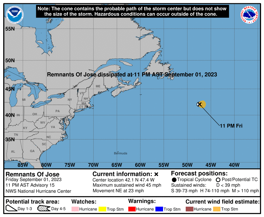
Just look at this mess. To bring back my comments from August 17th and I shake my head. Gert was a Trop Storm for about 16mins before downgraded to a depression.

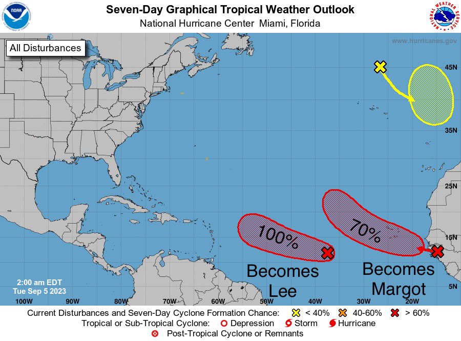
And just look at this forecast cone for Trop storm Jose. What a joke. Oh and That X just off the African coast has a 100% chance of being named according to the NHC, but is already headed NW at 15mph meaning it it will be named, recurve and gone before you can shake a hand. Not a single one of these would have been identified 50yrs ago. Jus sayin
_________________
"In weather and in life, there's no winning and losing; there's only winning and learning."
WINTER 2012/2013 TOTALS 43.65"WINTER 2017/2018 TOTALS 62.85" WINTER 2022/2023 TOTALS 4.9"
WINTER 2013/2014 TOTALS 64.85"WINTER 2018/2019 TOTALS 14.25" WINTER 2023/2024 TOTALS 13.1"
WINTER 2014/2015 TOTALS 71.20"WINTER 2019/2020 TOTALS 6.35"
WINTER 2015/2016 TOTALS 35.00"WINTER 2020/2021 TOTALS 37.75"
WINTER 2016/2017 TOTALS 42.25"WINTER 2021/2022 TOTALS 31.65"

sroc4- Admin

- Posts : 8354
Reputation : 302
Join date : 2013-01-07
Location : Wading River, LI
kalleg and rb924119 like this post
Re: 2023 Atlantic Tropics season
![]() by rb924119 Fri Sep 01, 2023 3:53 pm
by rb924119 Fri Sep 01, 2023 3:53 pm
rb924119- Meteorologist

- Posts : 6928
Reputation : 194
Join date : 2013-02-06
Age : 32
Location : Greentown, Pa
Re: 2023 Atlantic Tropics season
![]() by rb924119 Fri Sep 01, 2023 3:55 pm
by rb924119 Fri Sep 01, 2023 3:55 pm
rb924119- Meteorologist
- Posts : 6928
Reputation : 194
Join date : 2013-02-06
Age : 32
Location : Greentown, Pa
sroc4, kalleg and jmanley32 like this post
Re: 2023 Atlantic Tropics season
![]() by jmanley32 Fri Sep 01, 2023 5:36 pm
by jmanley32 Fri Sep 01, 2023 5:36 pm
Yup Euro has it, GFS had a fantasy land monster sized cat 2 cane just offshore so that time frame def needs to be watch for the east coast. I know model runs mean nothing but they are showing or sniffing out something in that time frame. That would be just my luck if we got hit by a cane around that week as my friend is coming from colorado that entire week span, so in fact we can probably stamp this one in cuz my luck has been bad lately.rb924119 wrote:We might have to watch the period from approximately September 9th through the 15th VERY carefully, folks. VERY CAREFULLY. And there are two ways we can get into trouble - either from a long-track system, which I think would be more likely at this time, or, a trough split that festers near the Southeast Coast, feeds back, and then gets drawn along the Eastern Seaboard as an anomalous trough dives in through the Plains.
jmanley32- Senior Enthusiast
- Posts : 20535
Reputation : 108
Join date : 2013-12-12
Age : 43
Location : Yonkers, NY
rb924119 likes this post
Re: 2023 Atlantic Tropics season
![]() by rb924119 Sat Sep 02, 2023 1:21 am
by rb924119 Sat Sep 02, 2023 1:21 am
rb924119 wrote:We might have to watch the period from approximately September 9th through the 15th VERY carefully, folks. VERY CAREFULLY. And there are two ways we can get into trouble - either from a long-track system, which I think would be more likely at this time, or, a trough split that festers near the Southeast Coast, feeds back, and then gets drawn along the Eastern Seaboard as an anomalous trough dives in through the Plains.
Tonight’s 00z GFS Op:

Still a long way out, and it’s the GFS, BUT, this type of evolution seemingly fits the pattern that I think I saw earlier. I’ll definitely have to do a deeper dive on this over the next few days to see if this idea actually has any real merit (in my opinion) or not, but at a quick glance, it looks like it has legs….
rb924119- Meteorologist
- Posts : 6928
Reputation : 194
Join date : 2013-02-06
Age : 32
Location : Greentown, Pa
kalleg likes this post
Re: 2023 Atlantic Tropics season
![]() by jmanley32 Sun Sep 03, 2023 3:31 pm
by jmanley32 Sun Sep 03, 2023 3:31 pm
jmanley32- Senior Enthusiast
- Posts : 20535
Reputation : 108
Join date : 2013-12-12
Age : 43
Location : Yonkers, NY
kalleg likes this post
Re: 2023 Atlantic Tropics season
![]() by amugs Sun Sep 03, 2023 10:27 pm
by amugs Sun Sep 03, 2023 10:27 pm
#LOCKITIN pic.twitter.com/7BNcJHBdF4
— #LOCKITIN (@lockingitin) September 3, 2023
_________________
Mugs
AKA:King: Snow Weenie
Self Proclaimed
WINTER 2014-15 : 55.12" +.02 for 6 coatings (avg. 35")
WINTER 2015-16 Total - 29.8" (Avg 35")
WINTER 2016-17 : 39.5" so far

amugs- Advanced Forecaster - Mod

- Posts : 15095
Reputation : 213
Join date : 2013-01-07
Age : 54
Location : Hillsdale,NJ
kalleg, rb924119 and jmanley32 like this post
Re: 2023 Atlantic Tropics season
![]() by jmanley32 Mon Sep 04, 2023 12:39 am
by jmanley32 Mon Sep 04, 2023 12:39 am
I think we all know not! at that long out BUT GFS has been very consistent with a east coast hit or hugger for days now, this will likely be hurricane Lee, unless some "no need to name" storm beats it to it. 95L looks healthy has a strong rotation but lacks convection but that should change over the next few days, long tracker this one.amugs wrote:#LOCKITIN pic.twitter.com/7BNcJHBdF4
— #LOCKITIN (@lockingitin) September 3, 2023
jmanley32- Senior Enthusiast
- Posts : 20535
Reputation : 108
Join date : 2013-12-12
Age : 43
Location : Yonkers, NY
kalleg and rb924119 like this post
Re: 2023 Atlantic Tropics season
![]() by sroc4 Mon Sep 04, 2023 10:09 am
by sroc4 Mon Sep 04, 2023 10:09 am
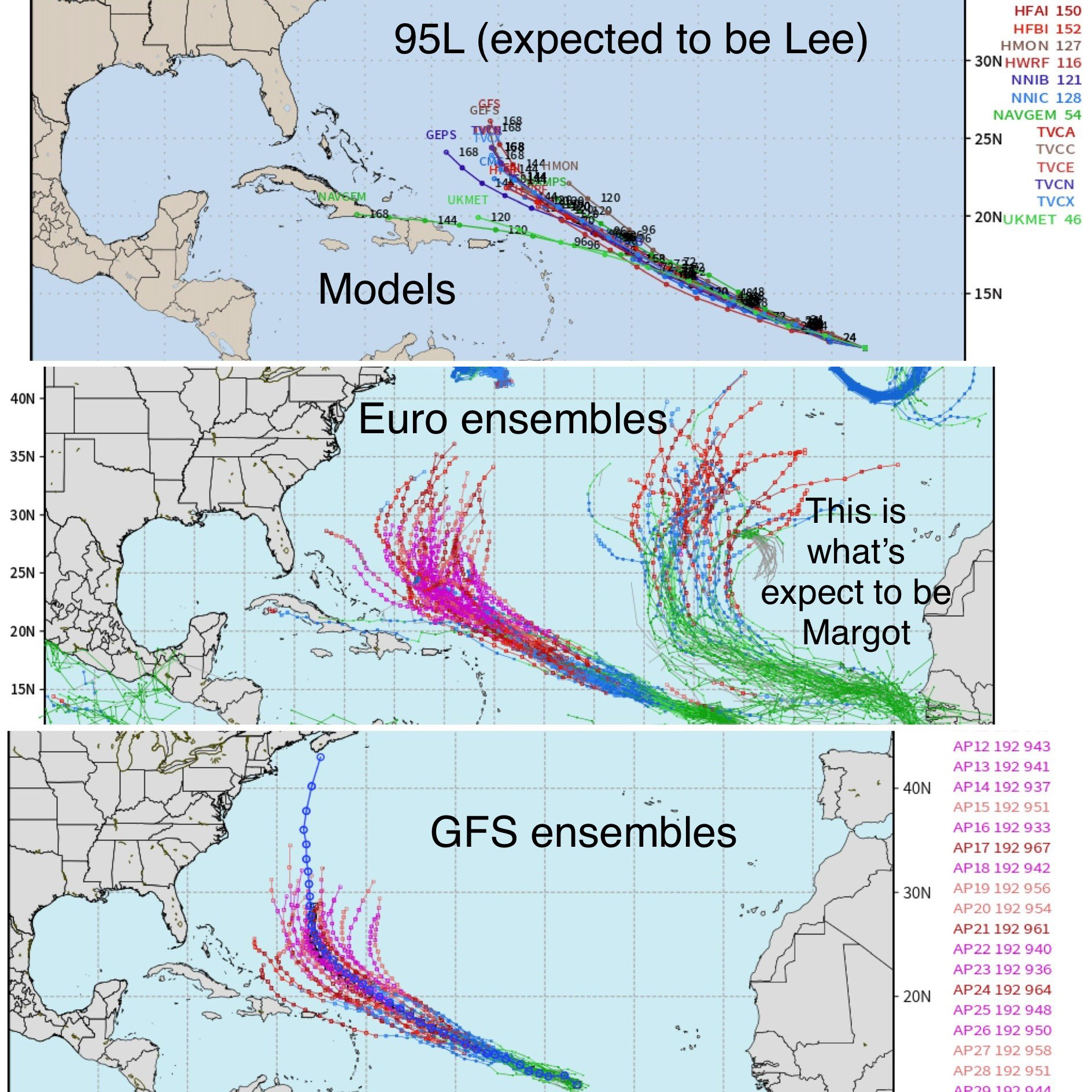
jmanley32 wrote:All the major models have the storm currently proged to develop heading towards the EC, GFS going into fantasy land above has a strong can skirt the coast and turn away uncomfortably close. Still way out past 10 days and we know that means nothing but Rb as stated above seems to feel the pattern might warrant a watchful eye for our area in about 10-12 days. Euro develops the system far slower and it's movement than CMC and GFS. Will be interesting to watch, impacts or not. Rb waiting on that analysis, of course it's the holiday don't expect it now. Hope everyone is enjoying.
Here is some analysis to show you why the GFS is doing what it's doing vs why the Euro is doing what it's doing. I don't care how consistent a model is showing a surface feature scraping or hitting the coast, its vital to focus on big picture, not surface maps at all, ideas. Big picture means do not look at anything below 500mb(Altitude) in the atmosphere if you are trying to get an idea if its even possible for this system to threaten the EC.
There will be multiple factors and details to analyze if we get under 3-5days, but In order for this system to even get close IT MUST "miss the first long wave trough(LWTrough)". If it doesn't it WILL recurve. At this lead time, this is point number 1.
Below compare GFS vs Euro. As we approach the time frame of Sept 10th-12th the system will be passing by the Lesser and Greater Antilles. At this time there will be a mean long wave trough somewhere along the EC. You can clearly see the depth, sharpness, and tilt to the trough varies greatly between the two models. Also look on the left side of the images ie: central CONUS. As the first trough lifts out there is the next one waiting to the west.
Back to the first point, Longwave trough along he EC, GFS lifts this up and out much faster which allows the system to escape its progressive flow. Once underneath the mean flow the GFS has the second trough, combined with a stronger Atlantic ridge nose north, to dig into the east coast capturing the system which steers it towards the coast.
Euro on the other hand, does not lift the first trough out quite as fast and is even more progressive that the GFS which imparts way more influence on the system for longer causing it to begin the recurve by the end of its run. The second trough on the Euro is a series of independent short waves, so its weaker as it makes its way east. Even if the system were to break off the mean flow of the first LW trough and it were to get captured by the second , it would be way too far east to bring it close enough to threaten the coast.


Of course this is verbatim the way these two models are portraying the pattern now. This WILL change. (SEE BELOW). As of this writing this is where the system, which is still an open tropical wave is. As you can see it's still closer to the African coast than it is to the Lesser Antilles.

First things first before we get excited about the coast, is answering the question of where is the system when it reaches the first circle? This is still 5-7days out. Once we get to the longitude of the lesser and greater Antilles, AND at what Latitude are we, only then can we begin to analyze the details of longwave troughs over the CONUS, and the Atlantic ridge which will then determine the next move.
Get caught up in the first LW Trough and Recurve? Break away and under the mean flow and meander a bit? Meander far enough west to get captured by the next LW Trough and threaten the coast? Or meander and get captured too far east and harmlessly recurve in a progressive flow? Etc, etc...
Many Many Many model runs to go. Lets see where we are when we get to next weekend.

_________________
"In weather and in life, there's no winning and losing; there's only winning and learning."
WINTER 2012/2013 TOTALS 43.65"WINTER 2017/2018 TOTALS 62.85" WINTER 2022/2023 TOTALS 4.9"
WINTER 2013/2014 TOTALS 64.85"WINTER 2018/2019 TOTALS 14.25" WINTER 2023/2024 TOTALS 13.1"
WINTER 2014/2015 TOTALS 71.20"WINTER 2019/2020 TOTALS 6.35"
WINTER 2015/2016 TOTALS 35.00"WINTER 2020/2021 TOTALS 37.75"
WINTER 2016/2017 TOTALS 42.25"WINTER 2021/2022 TOTALS 31.65"
sroc4- Admin
- Posts : 8354
Reputation : 302
Join date : 2013-01-07
Location : Wading River, LI
kalleg, rb924119 and weatherwatchermom like this post
Re: 2023 Atlantic Tropics season
![]() by rb924119 Mon Sep 04, 2023 10:28 am
by rb924119 Mon Sep 04, 2023 10:28 am
Bad news:
1. Because I am up north, I do not have access to good internet, so I will very likely not be able to do a video discussion (sorry 🥺).
2. Unfortunately, I do think that my initial concerns DO have merit, and think that anybody from the Outer Banks to Maine needs to watch the period from September 13th-17th very carefully for either a direct landfalling hurricane OR very near miss out to sea, but close enough to still bring considerable impacts to coastal areas. This timing has shifted a little bit from my earlier posting. Right now, I think the GFS Suite has a better handling of the overall depiction, although the lower-resolution ensemble is still catching the Operational.
Things I am seeing:
1. I think the JMA’s depiction of the MJO forecast is most accurate, with a phase 1-2 look. Even though that particular signal may not show in the chart itself, there is a VERY STRONG atmospheric signal for it which will begin emerging in about the next 5-7 days (check out Carl Schrek’s tropical monitoring hovmueller charts for 200mb velocity potential. The dark green between between 0-60E indicates very strong upper-level divergence there, which overlays perfectly with a MJO phase 1-2 response).
2. MJO phases 1 and 2 correspond with the following:
-heightened tropical activity in the western Atlantic and along the Eastern Seaboard
-signal for cooling temperatures/increased troughiness over the eastern CONUS
3. Progressive overall* Northern Hemispheric pattern, with what I consider to be:
-positive NAO/no 50N/50W blocking low
-70N/70E ridge
-neutral AO, WPO, EPO and PNA domains
-very strong, but transient* Hudson Bay ridge
I also note:
-recent stretch of strongly negative SOI index values which I consider to offset (at least partially) the warmth in Niño region 1.2.
-anomalously warm Atlantic, except for Franklin’s shadow
Per the above, my preliminary analysis leads me to think that:
1. My initial worry about an East Coast impact has merit, and is something that I think we need to watch very closely and take seriously. As I said, I think from the Outer Banks to Maine is most likely to be impacted in at least some form.
2. The overall pattern is progressive, HOWEVER, this doesn’t necessarily work to our advantage. I fully expect tropical development, and I think it will be a major hurricane. At this range, models ALWAYS underestimate the latent heat feedback that occurs, and therefore, ALWAYS underestimate the ridging to the northeast of the cyclone. This is a large part of why most ensemble members are still recurving it out to sea harmlessly. Climatology also favors this. However, with successive runs, if this cyclone develops as I expect it to, the Atlantic ridge should “trend” stronger and keep directing the storm more west or west-northwest longer, instead of breaking down and allowing an earlier recurve.
The above, in coordination with the progressive Northern Hemispheric pattern, should allow the leading trough (around days 7-
As the bottom half of the lead trough continues backing, the cyclone will be slowly making the bend. However, it will only be able to get as far as the interior south before a wave cuts beneath the Hudson Bay ridge (neutral PNA) and approaches. With the backing trough stuck over the interior Southeast, this begins to allow for SOME interaction with the cyclone, and an almost due north trajectory, assisted by the Atlantic ridging.
I DO NOT think we see a full capture and associated Sandy-type event. I’ve made the mistake a few times of giving these mid-latitude waves more “credit” than they deserve when they are relatively small and not overly anomalous. However, this fits the MJO phase 1-2 signal to a very large extent, and also fits the progressive pattern as it looks to me right now.
If I had to assign a very preliminary confidence assessment:
-harmlessly out to sea: 20%
-close enough to bring significant coastal impacts: 35%
-landfall somewhere between the Outer Banks and Maine: 30%
-landfall south of the Outer Banks: 10%
-Sandy-type situation: 5%
Hopefully that summed up what I’m thinking right now, and how I think the situation will unfold. But, as usual, if you have any questions, let me know, and……WE TRACK!
Also, I again apologize about not being able to do a video, but the internet here is, not good lol I’m working on fixing that issue though haha
rb924119- Meteorologist
- Posts : 6928
Reputation : 194
Join date : 2013-02-06
Age : 32
Location : Greentown, Pa
sroc4, kalleg, oldtimer and dolphins222 like this post
Re: 2023 Atlantic Tropics season
![]() by rb924119 Mon Sep 04, 2023 10:32 am
by rb924119 Mon Sep 04, 2023 10:32 am
sroc4 wrote:jmanley32 wrote:All the major models have the storm currently proged to develop heading towards the EC, GFS going into fantasy land above has a strong can skirt the coast and turn away uncomfortably close. Still way out past 10 days and we know that means nothing but Rb as stated above seems to feel the pattern might warrant a watchful eye for our area in about 10-12 days. Euro develops the system far slower and it's movement than CMC and GFS. Will be interesting to watch, impacts or not. Rb waiting on that analysis, of course it's the holiday don't expect it now. Hope everyone is enjoying.
Here is some analysis to show you why the GFS is doing what it's doing vs why the Euro is doing what it's doing. I don't care how consistent a model is showing a surface feature scraping or hitting the coast, its vital to focus on big picture, not surface maps at all, ideas. Big picture means do not look at anything below 500mb(Altitude) in the atmosphere if you are trying to get an idea if its even possible for this system to threaten the EC.
There will be multiple factors and details to analyze if we get under 3-5days, but In order for this system to even get close IT MUST "miss the first long wave trough(LWTrough)". If it doesn't it WILL recurve. At this lead time, this is point number 1.
Below compare GFS vs Euro. As we approach the time frame of Sept 10th-12th the system will be passing by the Lesser and Greater Antilles. At this time there will be a mean long wave trough somewhere along the EC. You can clearly see the depth, sharpness, and tilt to the trough varies greatly between the two models. Also look on the left side of the images ie: central CONUS. As the first trough lifts out there is the next one waiting to the west.
Back to the first point, Longwave trough along he EC, GFS lifts this up and out much faster which allows the system to escape its progressive flow. Once underneath the mean flow the GFS has the second trough, combined with a stronger Atlantic ridge nose north, to dig into the east coast capturing the system which steers it towards the coast.
Euro on the other hand, does not lift the first trough out quite as fast and is even more progressive that the GFS which imparts way more influence on the system for longer causing it to begin the recurve by the end of its run. The second trough on the Euro is a series of independent short waves, so its weaker as it makes its way east. Even if the system were to break off the mean flow of the first LW trough and it were to get captured by the second , it would be way too far east to bring it close enough to threaten the coast.
Of course this is verbatim the way these two models are portraying the pattern now. This WILL change. (SEE BELOW). As of this writing this is where the system, which is still an open tropical wave is. As you can see it's still closer to the African coast than it is to the Lesser Antilles.
First things first before we get excited about the coast, is answering the question of where is the system when it reaches the first circle? This is still 5-7days out. Once we get to the longitude of the lesser and greater Antilles, AND at what Latitude are we, only then can we begin to analyze the details of longwave troughs over the CONUS, and the Atlantic ridge which will then determine the next move.
Get caught up in the first LW Trough and Recurve? Break away and under the mean flow and meander a bit? Meander far enough west to get captured by the next LW Trough and threaten the coast? Or meander and get captured too far east and harmlessly recurve in a progressive flow? Etc, etc...
Many Many Many model runs to go. Lets see where we are when we get to next weekend.
Damn you! LOL
Great post, dude, and it merges seamlessly with mine regarding the differences between the modeling! We even did it in subject succession……if I didn’t know any better, I’d say we coordinated our posts haha
rb924119- Meteorologist
- Posts : 6928
Reputation : 194
Join date : 2013-02-06
Age : 32
Location : Greentown, Pa
sroc4, amugs and kalleg like this post
Re: 2023 Atlantic Tropics season
![]() by sroc4 Mon Sep 04, 2023 11:08 am
by sroc4 Mon Sep 04, 2023 11:08 am
_________________
"In weather and in life, there's no winning and losing; there's only winning and learning."
WINTER 2012/2013 TOTALS 43.65"WINTER 2017/2018 TOTALS 62.85" WINTER 2022/2023 TOTALS 4.9"
WINTER 2013/2014 TOTALS 64.85"WINTER 2018/2019 TOTALS 14.25" WINTER 2023/2024 TOTALS 13.1"
WINTER 2014/2015 TOTALS 71.20"WINTER 2019/2020 TOTALS 6.35"
WINTER 2015/2016 TOTALS 35.00"WINTER 2020/2021 TOTALS 37.75"
WINTER 2016/2017 TOTALS 42.25"WINTER 2021/2022 TOTALS 31.65"
sroc4- Admin
- Posts : 8354
Reputation : 302
Join date : 2013-01-07
Location : Wading River, LI
kalleg and rb924119 like this post
Re: 2023 Atlantic Tropics season
![]() by rb924119 Mon Sep 04, 2023 11:18 am
by rb924119 Mon Sep 04, 2023 11:18 am
sroc4 wrote:Lol Ray. As they say great minds think alike. As I was reading your post I was thinking damn they compliment each other very nicely. I really like your point about how easy it could be for modeling to underestimate the western flank of the ridge by underestimating the latent heat release. The one thing that we have to see play out though is MJO influence on the mean flow. Because Euro and to a lesser degree GFS are looking more like a 3-4 phase influence which is not nearly as enhancing to the upper levels as the phase 1-2 are for an EC threat. We shall see.
I don’t think it will be the MJO per se. I think the MJO signal itself may not show up outside the circle of death. But I think the atmosphere is going to be responding similarly to a phase 1-2 signal based on the expected equatorial velocity potential.
rb924119- Meteorologist
- Posts : 6928
Reputation : 194
Join date : 2013-02-06
Age : 32
Location : Greentown, Pa
sroc4 likes this post
Re: 2023 Atlantic Tropics season
![]() by rb924119 Mon Sep 04, 2023 11:20 am
by rb924119 Mon Sep 04, 2023 11:20 am
rb924119 wrote:sroc4 wrote:Lol Ray. As they say great minds think alike. As I was reading your post I was thinking damn they compliment each other very nicely. I really like your point about how easy it could be for modeling to underestimate the western flank of the ridge by underestimating the latent heat release. The one thing that we have to see play out though is MJO influence on the mean flow. Because Euro and to a lesser degree GFS are looking more like a 3-4 phase influence which is not nearly as enhancing to the upper levels as the phase 1-2 are for an EC threat. We shall see.
I don’t think it will be the MJO per se. I think the MJO signal itself may not show up outside the circle of death. But I think the atmosphere is going to be responding similarly to a phase 1-2 signal based on the expected equatorial velocity potential.

rb924119- Meteorologist
- Posts : 6928
Reputation : 194
Join date : 2013-02-06
Age : 32
Location : Greentown, Pa
sroc4 likes this post
Re: 2023 Atlantic Tropics season
![]() by jmanley32 Mon Sep 04, 2023 11:20 am
by jmanley32 Mon Sep 04, 2023 11:20 am
jmanley32- Senior Enthusiast
- Posts : 20535
Reputation : 108
Join date : 2013-12-12
Age : 43
Location : Yonkers, NY
Re: 2023 Atlantic Tropics season
![]() by jmanley32 Mon Sep 04, 2023 3:48 pm
by jmanley32 Mon Sep 04, 2023 3:48 pm

jmanley32- Senior Enthusiast
- Posts : 20535
Reputation : 108
Join date : 2013-12-12
Age : 43
Location : Yonkers, NY
kalleg likes this post
Re: 2023 Atlantic Tropics season
![]() by amugs Mon Sep 04, 2023 4:49 pm
by amugs Mon Sep 04, 2023 4:49 pm
This for sure would spell trouble along the coast in many ways by 12z GFS

HUGE trough over GL and a decent HP over Nova Scotia

_________________
Mugs
AKA:King: Snow Weenie
Self Proclaimed
WINTER 2014-15 : 55.12" +.02 for 6 coatings (avg. 35")
WINTER 2015-16 Total - 29.8" (Avg 35")
WINTER 2016-17 : 39.5" so far
amugs- Advanced Forecaster - Mod
- Posts : 15095
Reputation : 213
Join date : 2013-01-07
Age : 54
Location : Hillsdale,NJ
kalleg and dolphins222 like this post
Re: 2023 Atlantic Tropics season
![]() by jmanley32 Mon Sep 04, 2023 5:53 pm
by jmanley32 Mon Sep 04, 2023 5:53 pm
06z was a eyepopper.amugs wrote:Great analytical discussions by both Rb abd SROC. Excellent valid points made. The HP locatoins and UL trough locations will have a huge impact on the system. Many variables but something to definitely be watching as we move up in time. No psiking the football of its OTS or its a hit but it is intruiging.
This for sure would spell trouble along the coast in many ways by 12z GFS
HUGE trough over GL and a decent HP over Nova Scotia
jmanley32- Senior Enthusiast
- Posts : 20535
Reputation : 108
Join date : 2013-12-12
Age : 43
Location : Yonkers, NY
Re: 2023 Atlantic Tropics season
![]() by amugs Tue Sep 05, 2023 11:31 am
by amugs Tue Sep 05, 2023 11:31 am
Here's the true plot - a tad south of what the forecast is showing

_________________
Mugs
AKA:King: Snow Weenie
Self Proclaimed
WINTER 2014-15 : 55.12" +.02 for 6 coatings (avg. 35")
WINTER 2015-16 Total - 29.8" (Avg 35")
WINTER 2016-17 : 39.5" so far
amugs- Advanced Forecaster - Mod
- Posts : 15095
Reputation : 213
Join date : 2013-01-07
Age : 54
Location : Hillsdale,NJ
Re: 2023 Atlantic Tropics season
![]() by jmanley32 Tue Sep 05, 2023 1:51 pm
by jmanley32 Tue Sep 05, 2023 1:51 pm
jmanley32- Senior Enthusiast
- Posts : 20535
Reputation : 108
Join date : 2013-12-12
Age : 43
Location : Yonkers, NY
Re: 2023 Atlantic Tropics season
![]() by dkodgis Tue Sep 05, 2023 2:04 pm
by dkodgis Tue Sep 05, 2023 2:04 pm

dkodgis- Senior Enthusiast
- Posts : 2560
Reputation : 98
Join date : 2013-12-29
Re: 2023 Atlantic Tropics season
![]() by jmanley32 Tue Sep 05, 2023 2:09 pm
by jmanley32 Tue Sep 05, 2023 2:09 pm
You feel its going to be a major threat? Rb and to some extent scott agree I guess, but too far off, I think the Euro sees it getting caught up in that first kick that scott talked about.dkodgis wrote:Looks like it’s turning into something. I don’t buy the models taking it away from the east cost.
jmanley32- Senior Enthusiast
- Posts : 20535
Reputation : 108
Join date : 2013-12-12
Age : 43
Location : Yonkers, NY
dkodgis likes this post
Re: 2023 Atlantic Tropics season
![]() by dkodgis Tue Sep 05, 2023 2:33 pm
by dkodgis Tue Sep 05, 2023 2:33 pm
dkodgis- Senior Enthusiast
- Posts : 2560
Reputation : 98
Join date : 2013-12-29
kalleg and jmanley32 like this post
Re: 2023 Atlantic Tropics season
![]() by sroc4 Tue Sep 05, 2023 3:21 pm
by sroc4 Tue Sep 05, 2023 3:21 pm

_________________
"In weather and in life, there's no winning and losing; there's only winning and learning."
WINTER 2012/2013 TOTALS 43.65"WINTER 2017/2018 TOTALS 62.85" WINTER 2022/2023 TOTALS 4.9"
WINTER 2013/2014 TOTALS 64.85"WINTER 2018/2019 TOTALS 14.25" WINTER 2023/2024 TOTALS 13.1"
WINTER 2014/2015 TOTALS 71.20"WINTER 2019/2020 TOTALS 6.35"
WINTER 2015/2016 TOTALS 35.00"WINTER 2020/2021 TOTALS 37.75"
WINTER 2016/2017 TOTALS 42.25"WINTER 2021/2022 TOTALS 31.65"
sroc4- Admin
- Posts : 8354
Reputation : 302
Join date : 2013-01-07
Location : Wading River, LI
kalleg, jmanley32 and weatherwatchermom like this post
Page 5 of 20 • 1, 2, 3, 4, 5, 6 ... 12 ... 20 ![]()
|
|
|