JAN 6th-7th Storm Thread I
+22
Coachgriff
CPcantmeasuresnow
phil155
docstox12
Artechmetals
Dunnzoo
DAYBLAZER
sroc4
frank 638
billg315
Irish
tomsriversnowstorm
dsix85
aiannone
amugs
SENJsnowman
rb924119
heehaw453
nutleyblizzard
jmanley32
dkodgis
Frank_Wx
26 posters
Page 15 of 16
Page 15 of 16 •  1 ... 9 ... 14, 15, 16
 Re: JAN 6th-7th Storm Thread I
I guess those of us along the njtpk, SE of 287 will have to wait a bit longer as this one is just not our storm. For those that do get in on the snow I hope you all enjoy
phil155- Pro Enthusiast

- Posts : 483
Join date : 2019-12-16
 Re: JAN 6th-7th Storm Thread I
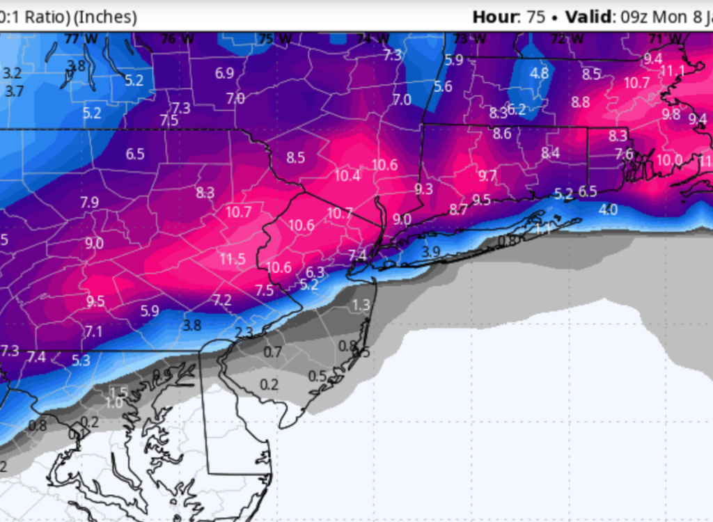
So the 06z GFS is pretty much holding steady with heavy snow totals north and west of a line from the NW Philly burbs to NYC to the north shore of LI. Right along that line is the battle zone between snow, sleet and rain keeping totals in the 3-6” range and south and east of it you pretty much get skunked with just rain, ver little snow. It also continues to show some enhanced snow for some spots Sunday at storms end from that second wave of energy swinging in behind the storm.
The 06z NAM is what I’ll best describe as being, not good for most. Warmer, rainier and the line separating a 1-3” slopfest from heavy snows is all the way up in extreme NW NJ and the LHV north of the NYC metro.
The best we can hope for with these runs would be that the GFS is right or that the most recent NAM and Euro runs were temporary blips and adjust back colder today.
billg315- Advanced Forecaster - Mod

- Posts : 4483
Join date : 2015-01-24
rb924119 and heehaw453 like this post
 Re: JAN 6th-7th Storm Thread I
phil155 wrote:I guess those of us along the njtpk, SE of 287 will have to wait a bit longer as this one is just not our storm. For those that do get in on the snow I hope you all enjoy
Agreed and we may be waiting until the 18th or so. Things look even more warm and rainy coming up over the next week.

Irish- Pro Enthusiast

- Posts : 788
Reputation : 19
Join date : 2019-01-16
Age : 45
Location : Old Bridge, NJ

billg315- Advanced Forecaster - Mod

- Posts : 4483
Reputation : 185
Join date : 2015-01-24
Age : 50
Location : Flemington, NJ
 Re: JAN 6th-7th Storm Thread I
Yupp. The immediate metro area took a turn for the worse last night/early this morning. One last chance at 12z
_________________
-Alex Iannone-

aiannone- Senior Enthusiast - Mod

- Posts : 4815
Reputation : 92
Join date : 2013-01-07
Location : Saint James, LI (Northwest Suffolk Co.)
 Re: JAN 6th-7th Storm Thread I
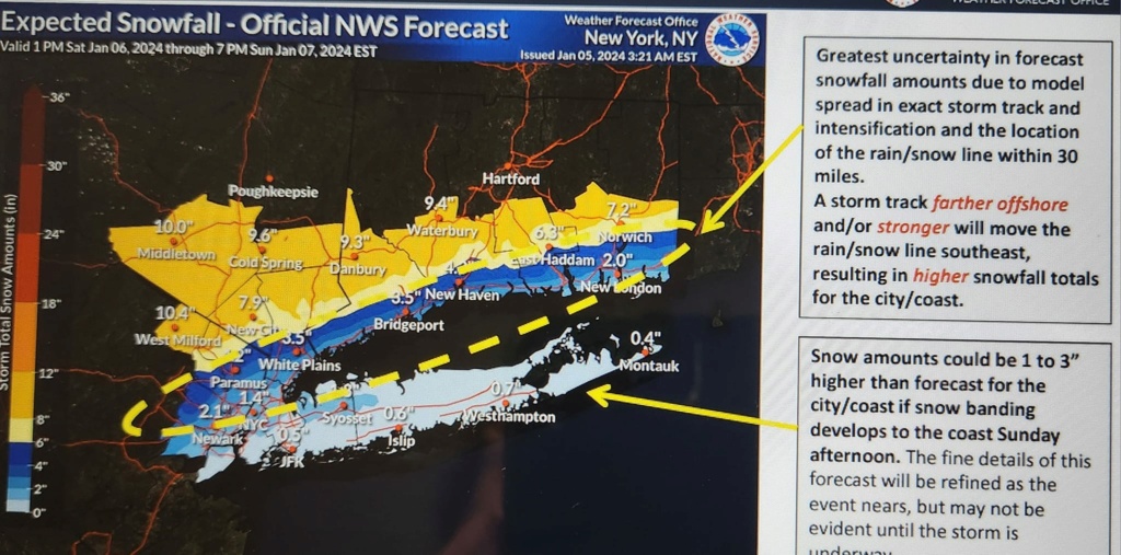
Bill said it well. Good overrunning air mass in place. Dew points in the interior are lower and middle teens and upper teens lower 20's on coastal plain.
There is bust potential but based on what I see this what I will go with for snow amounts.
Immediate Jersey Shore - T-1"
I95/LI/NYC some measurable snowfall c-2" LOW CONFIDENCE BUST POTENTIAL TOO LOW
EPA 1-3" approaches 3" closer to 78 LOW CONFIDENCE BUST POTENTIAL TOO LOW
NEPA/NW NJ 5"-10" > 1000' ASL otherwise 4-8" HIGH CONFIDENCE
LHV Orange County 5"-10" HIGH CONFIDENCE
If folks in the 5-10" zone get 1' which I believe is the ceiling it will be isolated incidents.
heehaw453- Advanced Forecaster

- Posts : 3906
Reputation : 86
Join date : 2014-01-20
Location : Bedminster Township, PA Elevation 600' ASL
CPcantmeasuresnow and rb924119 like this post
 Re: JAN 6th-7th Storm Thread I
06Z Euro
If you want snow you really don't want to be within 25 miles of that line IMO. That's where the mid-level energy crosses and it will generate a warm tongue. Keep seeing this pop up so I have no reason to doubt it. If folks in my low confidence zone get more it's because this moved SE from where it's modelled.
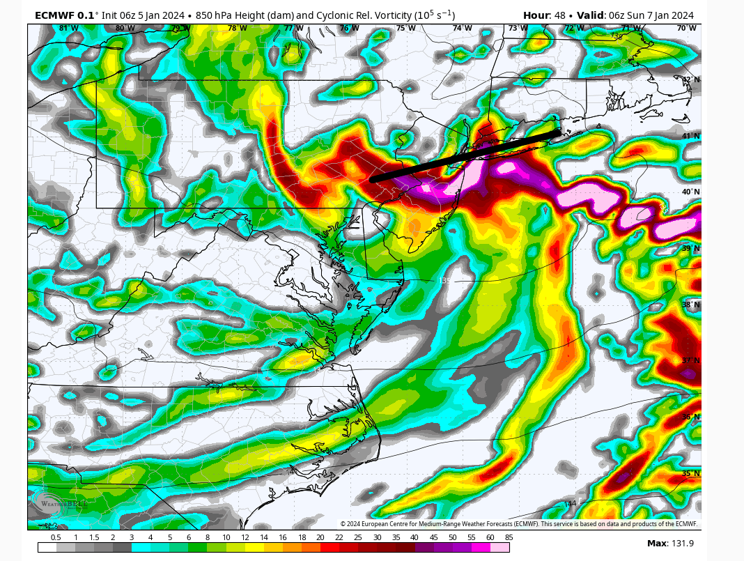
If you want snow you really don't want to be within 25 miles of that line IMO. That's where the mid-level energy crosses and it will generate a warm tongue. Keep seeing this pop up so I have no reason to doubt it. If folks in my low confidence zone get more it's because this moved SE from where it's modelled.

heehaw453- Advanced Forecaster

- Posts : 3906
Reputation : 86
Join date : 2014-01-20
Location : Bedminster Township, PA Elevation 600' ASL
CPcantmeasuresnow and rb924119 like this post
 Re: JAN 6th-7th Storm Thread I
Mr Doom and GloomIrish wrote:phil155 wrote:I guess those of us along the njtpk, SE of 287 will have to wait a bit longer as this one is just not our storm. For those that do get in on the snow I hope you all enjoy
Agreed and we may be waiting until the 18th or so. Things look even more warm and rainy coming up over the next week.
Koroptim- Posts : 29
Reputation : 0
Join date : 2013-01-16
 Re: JAN 6th-7th Storm Thread I
It's definitely not looking good for my thoughts of an I-95 Corridor jackpot, but I'll give it until 00z before I completely accept defeat and adjust the jackpot zone. However, I'm going to hold firm on my maximum range of 12-18" based on the ratios that I'm calculating. I admit that it seems quite high, but math doesn't lie. This snow, where it does fall and doesn't mix, should have a high fluff factor and maximized accumulation efficiency. It will certainly be an interesting test of my methods for this, although anecdotally, I have used them with a lot of success in the past.
I wish that I wasn't working, though, so I could actually devote time to making a full forecast map :/ someday I'll be in a position to be able to do that regularly.....at least that's the goal right now. Anyway....
rb924119- Meteorologist

- Posts : 6928
Reputation : 194
Join date : 2013-02-06
Age : 32
Location : Greentown, Pa
amugs, CPcantmeasuresnow, 1190ftalt, Artingerb and JT33 like this post
 Re: JAN 6th-7th Storm Thread I
heehaw453 wrote:Bill said it well. Good overrunning air mass in place. Dew points in the interior are lower and middle teens and upper teens lower 20's on coastal plain.
There is bust potential but based on what I see this what I will go with for snow amounts.
Immediate Jersey Shore - T-1"
I95/LI/NYC some measurable snowfall c-2" LOW CONFIDENCE BUST POTENTIAL TOO LOW
EPA 1-3" approaches 3" closer to 78 LOW CONFIDENCE BUST POTENTIAL TOO LOW
NEPA/NW NJ 5"-10" > 1000' ASL otherwise 4-8" HIGH CONFIDENCE
LHV Orange County 5"-10" HIGH CONFIDENCE
If folks in the 5-10" zone get 1' which I believe is the ceiling it will be isolated incidents.
Based on current guidance, I think this is definitely reasonable. The southeast shift notwithstanding, the only thing I would stray from is your max totals, as I just touched on in my previous response to Jman.
rb924119- Meteorologist

- Posts : 6928
Reputation : 194
Join date : 2013-02-06
Age : 32
Location : Greentown, Pa
 Re: JAN 6th-7th Storm Thread I
Latest SREFS were a step in the wrong direction - they hold onto the primary longer now, and don't close off the lower-level circulation (850 hPa) until it's at about the NY Bight. This allows too much warm air to get drawn in all the way to Sussex County, NJ. That said, they are usually too amplified, but it's not a great sign for the incoming NAM run, in my opinion.
rb924119- Meteorologist

- Posts : 6928
Reputation : 194
Join date : 2013-02-06
Age : 32
Location : Greentown, Pa
 Re: JAN 6th-7th Storm Thread I
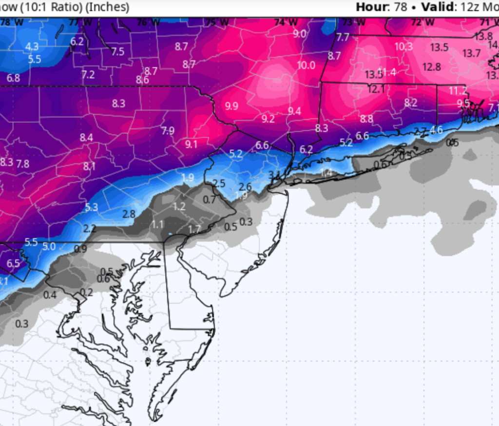
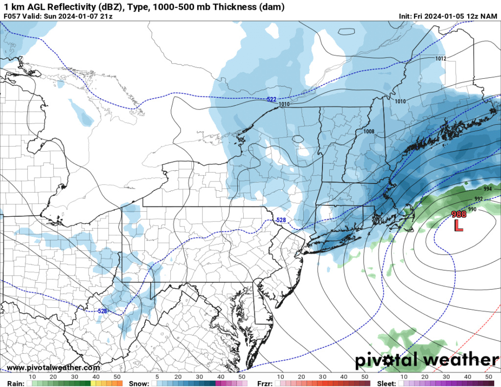
12z NAM definitely more amplified. Yikes.
rb924119- Meteorologist

- Posts : 6928
Reputation : 194
Join date : 2013-02-06
Age : 32
Location : Greentown, Pa
 Re: JAN 6th-7th Storm Thread I
I'll tell you what, though, whoever can stay cold enough through the column is gonna absolutely THUMP for several hours. This should amplify the forcing mechanisms in play. Let's see how this plays out.
rb924119- Meteorologist

- Posts : 6928
Reputation : 194
Join date : 2013-02-06
Age : 32
Location : Greentown, Pa
 Re: JAN 6th-7th Storm Thread I
rb924119 wrote:I'll tell you what, though, whoever can stay cold enough through the column is gonna absolutely THUMP for several hours. This should amplify the forcing mechanisms in play. Let's see how this plays out.
12z NAM is tough for anyone south and east of 287
_________________
-Alex Iannone-

aiannone- Senior Enthusiast - Mod

- Posts : 4815
Reputation : 92
Join date : 2013-01-07
Location : Saint James, LI (Northwest Suffolk Co.)
 Re: JAN 6th-7th Storm Thread I
_________________
-Alex Iannone-

aiannone- Senior Enthusiast - Mod

- Posts : 4815
Reputation : 92
Join date : 2013-01-07
Location : Saint James, LI (Northwest Suffolk Co.)
 Re: JAN 6th-7th Storm Thread I
aiannone wrote:rb924119 wrote:I'll tell you what, though, whoever can stay cold enough through the column is gonna absolutely THUMP for several hours. This should amplify the forcing mechanisms in play. Let's see how this plays out.
12z NAM is tough for anyone south and east of 287
Don't underestimate the frontend thump, especially with a good airmass in place. I think KNYC is in a spot where it'll snow until the back edge approaches and then it'll transition to light rain/drizzle. Beyond that, at least verbatim, the best wrap-around snow stays north and west of there, since the lower-level circulation will be overhead.
rb924119- Meteorologist

- Posts : 6928
Reputation : 194
Join date : 2013-02-06
Age : 32
Location : Greentown, Pa

aiannone- Senior Enthusiast - Mod

- Posts : 4815
Reputation : 92
Join date : 2013-01-07
Location : Saint James, LI (Northwest Suffolk Co.)

aiannone- Senior Enthusiast - Mod

- Posts : 4815
Reputation : 92
Join date : 2013-01-07
Location : Saint James, LI (Northwest Suffolk Co.)
rb924119- Meteorologist

- Posts : 6928
Reputation : 194
Join date : 2013-02-06
Age : 32
Location : Greentown, Pa

aiannone- Senior Enthusiast - Mod

- Posts : 4815
Reputation : 92
Join date : 2013-01-07
Location : Saint James, LI (Northwest Suffolk Co.)
rb924119- Meteorologist

- Posts : 6928
Reputation : 194
Join date : 2013-02-06
Age : 32
Location : Greentown, Pa
 Re: JAN 6th-7th Storm Thread I
rb924119 wrote:
It's definitely not looking good for my thoughts of an I-95 Corridor jackpot, but I'll give it until 00z before I completely accept defeat and adjust the jackpot zone. However, I'm going to hold firm on my maximum range of 12-18" based on the ratios that I'm calculating. I admit that it seems quite high, but math doesn't lie. This snow, where it does fall and doesn't mix, should have a high fluff factor and maximized accumulation efficiency. It will certainly be an interesting test of my methods for this, although anecdotally, I have used them with a lot of success in the past.
I wish that I wasn't working, though, so I could actually devote time to making a full forecast map :/ someday I'll be in a position to be able to do that regularly.....at least that's the goal right now. Anyway....
It will be interesting to see how your math works out for the ratios, the mainstream media forecasts are saying it will be a heavy, wet snow.
_________________
Janet
Snowfall winter of 2023-2024 17.5"
Snowfall winter of 2022-2023 6.0"
Snowfall winter of 2021-2022 17.6" 1" sleet 2/25/22
Snowfall winter of 2020-2021 51.1"
Snowfall winter of 2019-2020 8.5"
Snowfall winter of 2018-2019 25.1"
Snowfall winter of 2017-2018 51.9"
Snowfall winter of 2016-2017 45.6"
Snowfall winter of 2015-2016 29.5"
Snowfall winter of 2014-2015 50.55"
Snowfall winter of 2013-2014 66.5"
Dunnzoo- Senior Enthusiast - Mod

- Posts : 4905
Reputation : 68
Join date : 2013-01-11
Age : 62
Location : Westwood, NJ
rb924119 and 1190ftalt like this post
 Re: JAN 6th-7th Storm Thread I
_________________
Janet
Snowfall winter of 2023-2024 17.5"
Snowfall winter of 2022-2023 6.0"
Snowfall winter of 2021-2022 17.6" 1" sleet 2/25/22
Snowfall winter of 2020-2021 51.1"
Snowfall winter of 2019-2020 8.5"
Snowfall winter of 2018-2019 25.1"
Snowfall winter of 2017-2018 51.9"
Snowfall winter of 2016-2017 45.6"
Snowfall winter of 2015-2016 29.5"
Snowfall winter of 2014-2015 50.55"
Snowfall winter of 2013-2014 66.5"

Dunnzoo- Senior Enthusiast - Mod

- Posts : 4905
Reputation : 68
Join date : 2013-01-11
Age : 62
Location : Westwood, NJ
 Re: JAN 6th-7th Storm Thread I
12z RGEM basically held serve, slightly better than 06z, but that's likely just typical model cycling between runs.
rb924119- Meteorologist

- Posts : 6928
Reputation : 194
Join date : 2013-02-06
Age : 32
Location : Greentown, Pa
 Re: JAN 6th-7th Storm Thread I
Dunnzoo wrote:rb924119 wrote:
It's definitely not looking good for my thoughts of an I-95 Corridor jackpot, but I'll give it until 00z before I completely accept defeat and adjust the jackpot zone. However, I'm going to hold firm on my maximum range of 12-18" based on the ratios that I'm calculating. I admit that it seems quite high, but math doesn't lie. This snow, where it does fall and doesn't mix, should have a high fluff factor and maximized accumulation efficiency. It will certainly be an interesting test of my methods for this, although anecdotally, I have used them with a lot of success in the past.
I wish that I wasn't working, though, so I could actually devote time to making a full forecast map :/ someday I'll be in a position to be able to do that regularly.....at least that's the goal right now. Anyway....
It will be interesting to see how your math works out for the ratios, the mainstream media forecasts are saying it will be a heavy, wet snow.
In places that are going to change over it will gradually get wetter until it changes, which only makes sense. So yeah, in that sense, I agree. But I think to make a blanket statement that it's going to be a wet snow is not correct for those who don't change over.
rb924119- Meteorologist

- Posts : 6928
Reputation : 194
Join date : 2013-02-06
Age : 32
Location : Greentown, Pa
Dunnzoo and 1190ftalt like this post
 Re: JAN 6th-7th Storm Thread I
12z GFS through 30 looks more amplified.
rb924119- Meteorologist

- Posts : 6928
Reputation : 194
Join date : 2013-02-06
Age : 32
Location : Greentown, Pa
heehaw453- Advanced Forecaster

- Posts : 3906
Reputation : 86
Join date : 2014-01-20
Location : Bedminster Township, PA Elevation 600' ASL
rb924119 likes this post
Page 15 of 16 •  1 ... 9 ... 14, 15, 16
Page 15 of 16
Permissions in this forum:
You cannot reply to topics in this forum|
|
|

 Home
Home