JAN 6th-7th Storm Thread I
+22
Coachgriff
CPcantmeasuresnow
phil155
docstox12
Artechmetals
Dunnzoo
DAYBLAZER
sroc4
frank 638
billg315
Irish
tomsriversnowstorm
dsix85
aiannone
amugs
SENJsnowman
rb924119
heehaw453
nutleyblizzard
jmanley32
dkodgis
Frank_Wx
26 posters
Page 4 of 16
Page 4 of 16 •  1, 2, 3, 4, 5 ... 10 ... 16
 Re: JAN 6th-7th Storm Thread I
aiannone wrote:I appreciate the optimism ray. But besides the exact track of the low I guess we have to consider the mesoscale features upton is pointing out and the major one is the coastal front. That is the kiss of death for LI and NYC and they are expecting one to develop sending warm ocean winds right into us.
It’s not optimism - I’m not blindly saying that it’ll come back. I have reasons for it based on the whole pattern and forcing mechanisms in play.
If I had reasons to think that it will continue to trend north/warmer, I’d say so.
rb924119- Meteorologist

- Posts : 7033
Join date : 2013-02-06
jmanley32 likes this post
 Re: JAN 6th-7th Storm Thread I
rb924119 wrote:Idk why people are writing this off. 06z Euro? Way more consolidated than earlier runs, 6” into NYC. It didn’t go any further north. I’m with heehaw, and think this steadily comes back south a bit. We’ll see, but the pattern supports snow for the I-95 Corridor.
Even if NYC is outside of the heaviest snow axis, I prefer if people do not make definitive statements of the storm being “over” because we have a large contingency of members who live N&W of NYC and would like to read analysis. Banter should be in banter. I’m only quoting you because I agree this should not be written off
kalleg, rb924119 and heehaw453 like this post
 Re: JAN 6th-7th Storm Thread I
rb924119 wrote:SREFs are definitely wetter, no more amplified than they were previously. This is a good sign to me, but we’ll see how today goes.
Actually, looking at other levels as they’re coming out, they are notably improved at 850 hPa. While not completely closed off in time, there’s certainly an indication of an earlier organization than in previous runs. Again, considering their tendency to be too warm/amplified, this is a good sign.
rb924119- Meteorologist

- Posts : 7033
Reputation : 195
Join date : 2013-02-06
Age : 32
Location : Greentown, Pa
 Re: JAN 6th-7th Storm Thread I
Frank_Wx wrote:I prefer if people do not make definitive statements of the storm being “over” because we have a large contingency of members who live N&W of NYC and would like to read analysis. Banter should be in banter. I’m only quoting you because I agree this should not be written off
*Raises hand*
Been lurking but paying close attention to all the wonderful analysis you all have been providing. I hope everyone can cash in on something here, even a few inches is better than nothing given the absolutely dreadful winters of the past few years-- even up here in the NWNJ hills.
I must admit I am pressing for this event to come to fruition in at least some capacity up by me-- my now 2 1/2 year old daughter has never seen any sort of decent snowfall, and she's old enough now to enjoy the recreational aspects of it-- sledding, etc. She got very excited this week when I told her it might snow. So I'll keep my fingers crossed for the model runs today.

DAYBLAZER- Posts : 228
Reputation : 20
Join date : 2017-03-12
Location : Hopatcong, NJ Sussex County
Frank_Wx, docstox12, kalleg, rb924119, heehaw453 and JT33 like this post
 Re: JAN 6th-7th Storm Thread I
_________________
Janet
Snowfall winter of 2023-2024 17.5"
Snowfall winter of 2022-2023 6.0"
Snowfall winter of 2021-2022 17.6" 1" sleet 2/25/22
Snowfall winter of 2020-2021 51.1"
Snowfall winter of 2019-2020 8.5"
Snowfall winter of 2018-2019 25.1"
Snowfall winter of 2017-2018 51.9"
Snowfall winter of 2016-2017 45.6"
Snowfall winter of 2015-2016 29.5"
Snowfall winter of 2014-2015 50.55"
Snowfall winter of 2013-2014 66.5"
Dunnzoo- Senior Enthusiast - Mod

- Posts : 4920
Reputation : 68
Join date : 2013-01-11
Age : 62
Location : Westwood, NJ
rb924119 likes this post
 Re: JAN 6th-7th Storm Thread I
That’s not a bad look for Long Island
dsix85- Pro Enthusiast

- Posts : 349
Reputation : 8
Join date : 2014-01-01
Location : New York
 Re: JAN 6th-7th Storm Thread I
_________________
-Alex Iannone-

aiannone- Senior Enthusiast - Mod

- Posts : 4822
Reputation : 92
Join date : 2013-01-07
Location : Saint James, LI (Northwest Suffolk Co.)
 Re: JAN 6th-7th Storm Thread I
Frank_Wx wrote:Irish wrote:I84 and above enjoy this storm. It looks like your goose is cooked below this point. Hell, those in central and Southern NJ might just see an all rain event, with maybe some mixing here and there. And the next midweek storm looks to be all rain as well. The next check in looks to be for the 15th-20th time frame. GL to those up north and west.
Hi! Posts like these should be in the banter thread. A storm thread is meant for analysis, maps, questions about the storm, etc.
Apologies, figured I was commenting on the actual storm, and where it looks hit. I'll avoid commenting unless it's what you mentioned.

Irish- Pro Enthusiast

- Posts : 788
Reputation : 19
Join date : 2019-01-16
Age : 46
Location : Old Bridge, NJ
 Re: JAN 6th-7th Storm Thread I
Last edited by rb924119 on Thu Jan 04, 2024 9:30 am; edited 2 times in total
rb924119- Meteorologist

- Posts : 7033
Reputation : 195
Join date : 2013-02-06
Age : 32
Location : Greentown, Pa
 Re: JAN 6th-7th Storm Thread I
HAHAHA!! We werre for Ida and Irene and Floyd!!! Also 2002 Xmas Miracle storm too. We are do, positive vibes sister.
48 hours and recon flights today into the energy on the WC should be telling
_________________
Mugs
AKA:King: Snow Weenie
Self Proclaimed
WINTER 2014-15 : 55.12" +.02 for 6 coatings (avg. 35")
WINTER 2015-16 Total - 29.8" (Avg 35")
WINTER 2016-17 : 39.5" so far

amugs- Advanced Forecaster - Mod

- Posts : 15130
Reputation : 213
Join date : 2013-01-07
Age : 54
Location : Hillsdale,NJ
rb924119- Meteorologist

- Posts : 7033
Reputation : 195
Join date : 2013-02-06
Age : 32
Location : Greentown, Pa
 Re: JAN 6th-7th Storm Thread I
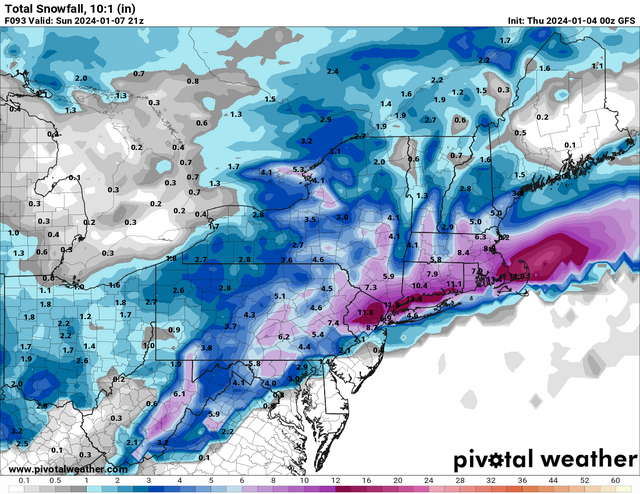
Hoping ur right mugs, I am in that 11 inch spot, in fact i think that number IS yonkers, pivotal weather is the only forecasting platform that outright puts yonkers on their maps as a point of reference. Not banking on that but it is funny how the GFS was our so called outlier and now it looks better than the other LR models lol. Need to see the SR models look like this. Trying to keep that positive juju even if my gut is saying otherwise. I guess the weather is as bi-polar as I am lolamugs wrote:
HAHAHA!! We werre for Ida and Irene and Floyd!!! Also 2002 Xmas Miracle storm too. We are do, positive vibes sister.
48 hours and recon flights today into the energy on the WC should be telling

jmanley32- Senior Enthusiast

- Posts : 20635
Reputation : 108
Join date : 2013-12-12
Age : 43
Location : Yonkers, NY

jmanley32- Senior Enthusiast

- Posts : 20635
Reputation : 108
Join date : 2013-12-12
Age : 43
Location : Yonkers, NY
 Re: JAN 6th-7th Storm Thread I
Looks like NAM is ALL SNOW KNYC…..waiting on better maps to confirm.
rb924119- Meteorologist

- Posts : 7033
Reputation : 195
Join date : 2013-02-06
Age : 32
Location : Greentown, Pa
 Re: JAN 6th-7th Storm Thread I
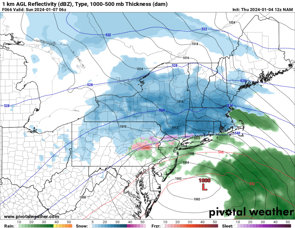
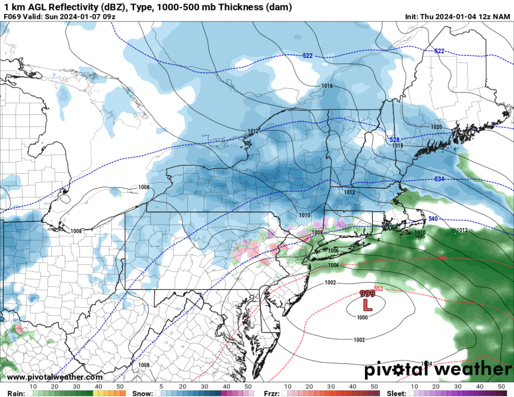
12z NAM is def S & E of previous run but still has coast and NYC as mainly rain, 1 more tick s & E and I think we are in the good stuff, being just north of NYC has actually worked out for me before, just far enough away that it can sometimes snow and change to rain as i hit the south bronx, its amazing how razor thin the rain snow line can be.

jmanley32- Senior Enthusiast

- Posts : 20635
Reputation : 108
Join date : 2013-12-12
Age : 43
Location : Yonkers, NY
 Re: JAN 6th-7th Storm Thread I
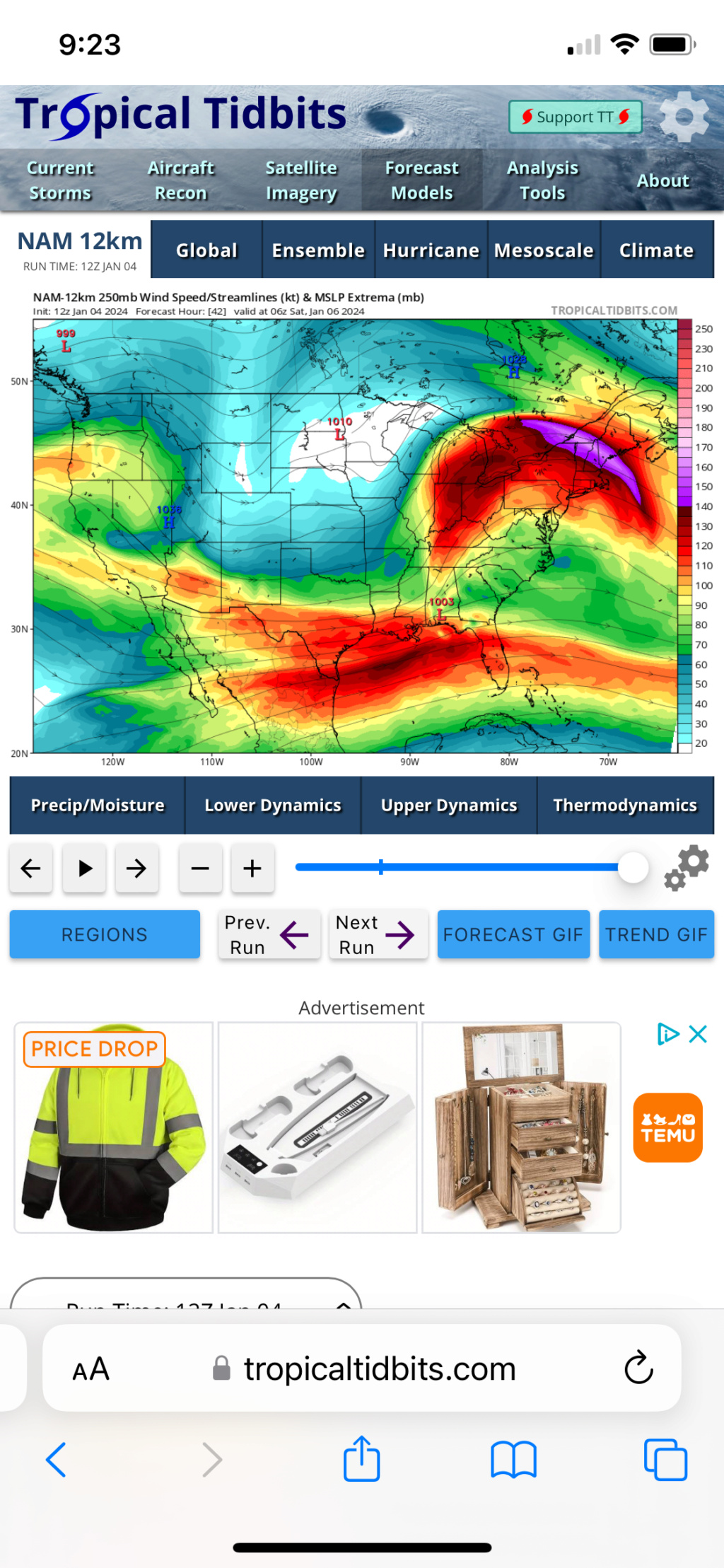
Kind of. See how the maximum wind band stretches back toward western PA? That helps expand the zone of forcing for ascent. Additionally, the maximum winds on this run are stronger than in earlier runs, which means the forcing will be stronger than it was before.
rb924119- Meteorologist

- Posts : 7033
Reputation : 195
Join date : 2013-02-06
Age : 32
Location : Greentown, Pa
 Re: JAN 6th-7th Storm Thread I
Did not look like it to me on TT, but its not very hi-res or close up snow map.rb924119 wrote:Looks like NAM is ALL SNOW KNYC…..waiting on better maps to confirm.

jmanley32- Senior Enthusiast

- Posts : 20635
Reputation : 108
Join date : 2013-12-12
Age : 43
Location : Yonkers, NY
 Re: JAN 6th-7th Storm Thread I
I just looed closer both of those are 12z runs but different time stamps, was that on purpose? I thought they were comparing the 06z to 12z.rb924119 wrote:
Kind of. See how the maximum wind band stretches back toward western PA? That helps expand the zone of forcing for ascent. Additionally, the maximum winds on this run are stronger than in earlier runs, which means the forcing will be stronger than it was before.

jmanley32- Senior Enthusiast

- Posts : 20635
Reputation : 108
Join date : 2013-12-12
Age : 43
Location : Yonkers, NY
 Re: JAN 6th-7th Storm Thread I
_________________
-Alex Iannone-

aiannone- Senior Enthusiast - Mod

- Posts : 4822
Reputation : 92
Join date : 2013-01-07
Location : Saint James, LI (Northwest Suffolk Co.)

aiannone- Senior Enthusiast - Mod

- Posts : 4822
Reputation : 92
Join date : 2013-01-07
Location : Saint James, LI (Northwest Suffolk Co.)
 Re: JAN 6th-7th Storm Thread I
jmanley32 wrote:Did not look like it to me on TT, but its not very hi-res or close up snow map.rb924119 wrote:Looks like NAM is ALL SNOW KNYC…..waiting on better maps to confirm.
Verbatim they are apparently on the line lol my bad, but Jimminy Crickets you’re right freakin’ thereeeeeeeee lol
Also love how it’s extending the precip shield further west even as the low continues to the east-northeast, which is what we should see in this scenario, as discussed earlier in the week.
rb924119- Meteorologist

- Posts : 7033
Reputation : 195
Join date : 2013-02-06
Age : 32
Location : Greentown, Pa
 Re: JAN 6th-7th Storm Thread I
The HP placement is a tad 3 mb stronger and about 25-30 miles more S
Good run and hopefully picking up on this.
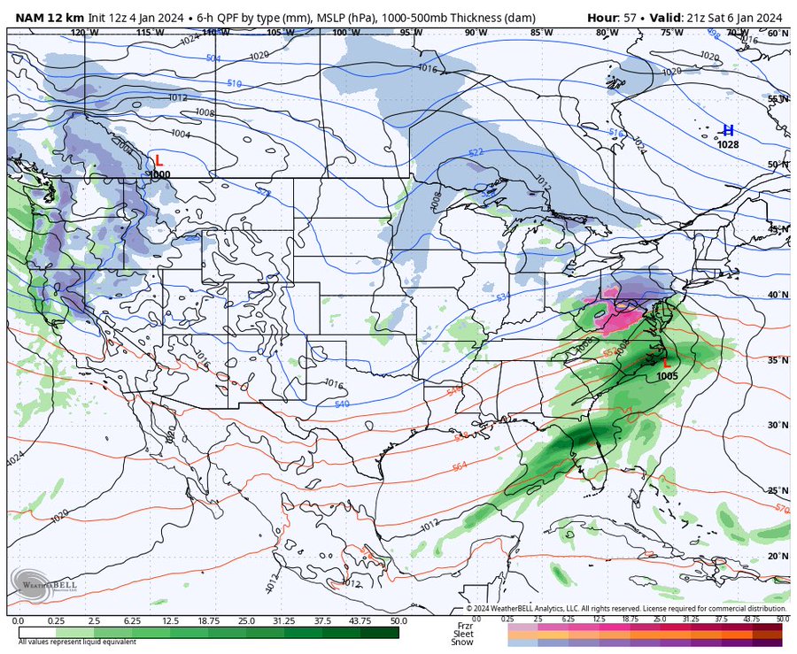
Good run and hopefully picking up on this.

_________________
Mugs
AKA:King: Snow Weenie
Self Proclaimed
WINTER 2014-15 : 55.12" +.02 for 6 coatings (avg. 35")
WINTER 2015-16 Total - 29.8" (Avg 35")
WINTER 2016-17 : 39.5" so far

amugs- Advanced Forecaster - Mod

- Posts : 15130
Reputation : 213
Join date : 2013-01-07
Age : 54
Location : Hillsdale,NJ
 Re: JAN 6th-7th Storm Thread I
jmanley32 wrote:I just looed closer both of those are 12z runs but different time stamps, was that on purpose? I thought they were comparing the 06z to 12z.rb924119 wrote:
Kind of. See how the maximum wind band stretches back toward western PA? That helps expand the zone of forcing for ascent. Additionally, the maximum winds on this run are stronger than in earlier runs, which means the forcing will be stronger than it was before.
Yeah, that was on purpose to show the evolution.
rb924119- Meteorologist

- Posts : 7033
Reputation : 195
Join date : 2013-02-06
Age : 32
Location : Greentown, Pa
 Re: JAN 6th-7th Storm Thread I
Huge shift of higher totals of snow on 12z NAM but not into NYC, they still see a changover to rain after a few inches max. Hoping this can tick a bit further south, but not enough to put the northern guys out, i think thats possible.

jmanley32- Senior Enthusiast

- Posts : 20635
Reputation : 108
Join date : 2013-12-12
Age : 43
Location : Yonkers, NY
rb924119 likes this post
 Re: JAN 6th-7th Storm Thread I
jmanley32 wrote:Huge shift of higher totals of snow on 12z NAM but not into NYC, they still see a changover to rain after a few inches max. Hoping this can tick a bit further south, but not enough to put the northern guys out, i think thats possible.
Trust the process
rb924119- Meteorologist

- Posts : 7033
Reputation : 195
Join date : 2013-02-06
Age : 32
Location : Greentown, Pa
 Re: JAN 6th-7th Storm Thread I
_________________
Mugs
AKA:King: Snow Weenie
Self Proclaimed
WINTER 2014-15 : 55.12" +.02 for 6 coatings (avg. 35")
WINTER 2015-16 Total - 29.8" (Avg 35")
WINTER 2016-17 : 39.5" so far

amugs- Advanced Forecaster - Mod

- Posts : 15130
Reputation : 213
Join date : 2013-01-07
Age : 54
Location : Hillsdale,NJ
 Re: JAN 6th-7th Storm Thread I
I know, I hate how razor sharp the cutoff is, literally 9.5 miles to my north it goes from 2-3 to 6+, amazing, i want to see at least a decent amount into the pink on TT to feel safe. Still thinking this may be a nowcast for NYC and my area even if models do show a change for the better, lots of things at play that change during storms as we have seen many times 2 years ago lolrb924119 wrote:jmanley32 wrote:Did not look like it to me on TT, but its not very hi-res or close up snow map.rb924119 wrote:Looks like NAM is ALL SNOW KNYC…..waiting on better maps to confirm.
Verbatim they are apparently on the line lol my bad, but Jimminy Crickets you’re right freakin’ thereeeeeeeee lol
Also love how it’s extending the precip shield further west even as the low continues to the east-northeast, which is what we should see in this scenario, as discussed earlier in the week.

jmanley32- Senior Enthusiast

- Posts : 20635
Reputation : 108
Join date : 2013-12-12
Age : 43
Location : Yonkers, NY
rb924119 likes this post
Page 4 of 16 •  1, 2, 3, 4, 5 ... 10 ... 16
Page 4 of 16
Permissions in this forum:
You cannot reply to topics in this forum|
|
|

 Home
Home
