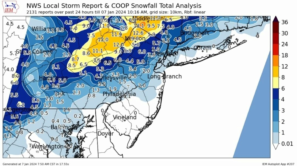
JAN 6th-7th Storm Part II
+44
sroc4
dfig529
sabamfa
lglickman1
JoeBx82
Artechmetals
algae888
weatherwatchermom
silentwreck
Aerojet514
nancy-j-s
emokid51783
brownie
DAYBLAZER
Brookster
Dunnzoo
1190ftalt
essexcountypete
toople
oldtimer
JT33
GreyBeard
CPcantmeasuresnow
2004blackwrx
frank 638
nutleyblizzard
Coachgriff
dkodgis
phil155
Irish
MattyICE
docstox12
dsix85
Koroptim
billg315
jmanley32
heehaw453
rb924119
hyde345
amugs
crippo84
Frozen.9
aiannone
Frank_Wx
48 posters
Page 24 of 26
Page 24 of 26 •  1 ... 13 ... 23, 24, 25, 26
 Re: JAN 6th-7th Storm Part II
Just finished shoveling. Ended with about 0.01” of very wet snow. The pics of those up north look incredible. Congrats!!
crippo84, 1190ftalt and heehaw453 like this post
 Re: JAN 6th-7th Storm Part II
Frank_Wx wrote:Just finished shoveling. Ended with about 0.01” of very wet snow. The pics of those up north look incredible. Congrats!!
Lol similar story reporting across the Hudson in East Village. At one point last night I saw a slushy quarter inch of slop on a few windshields.
1190ftalt - that's the stuff dreams are made of. One day I'm hoping I'll see something like that again here in the city!
crippo84- Posts : 383
Join date : 2013-11-07
1190ftalt likes this post
 Re: JAN 6th-7th Storm Part II
The surface low ended up tracking well inside the 40/70 BM. As of this morning it’s found right off the coast of NJ. It’s a weakling at 1000mb.
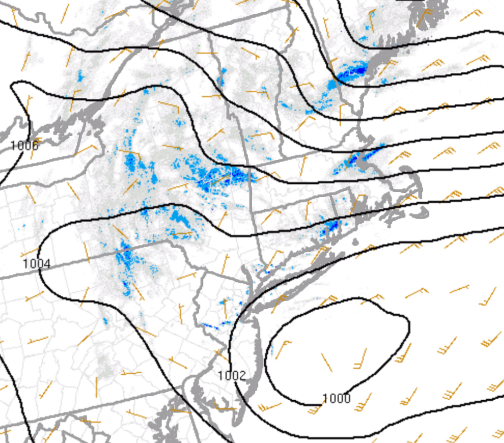
By Noon, the sub tropical jet streak sneaks its way into the area which allows the surface low to deepen to about 990mb. In the process we will see snow pickup again in the form of a CCB - mostly north of NYC. I can see Long Island getting into the action as well, but have a feeling any precip falls as rain or wet snow.


Current radar. This will all fill in (north of city) by late morning

By Noon, the sub tropical jet streak sneaks its way into the area which allows the surface low to deepen to about 990mb. In the process we will see snow pickup again in the form of a CCB - mostly north of NYC. I can see Long Island getting into the action as well, but have a feeling any precip falls as rain or wet snow.


Current radar. This will all fill in (north of city) by late morning
_________________
_______________________________________________________________________________________________________
CLICK HERE to view NJ Strong Snowstorm Classifications
 Re: JAN 6th-7th Storm Part II
So a bit of a recap. The storm closed off mid levels around 8 last night over DE. That's why the folks NW were seeing their best rates. Had that storm not got sheared due to resistance there would have widespread 1' with locally 2' amounts NW areas. and I believe I95/LI would have got into the game as it moved towards the BM. That was my wildcard with this storm. Models really didn't say it would happen, but you never know. Anyway I busted a bit in EPA as 3-5" was more the rule, but I think rest was ok. Just wish could have worked out better for more folks. Lets get next Sunday going!
Immediate Jersey Shore - T-1"
I95/LI/NYC some measurable snowfall c-2" LOW CONFIDENCE BUST POTENTIAL TOO LOW
EPA 1-3" approaches 3" closer to 78 LOW CONFIDENCE BUST POTENTIAL TOO LOW
NEPA/NW NJ 5"-10" > 1000' ASL otherwise 4-8" HIGH CONFIDENCE
LHV Orange County 5"-10" HIGH CONFIDENCE
If folks in the 5-10" zone get 1' which I believe is the ceiling it will be isolated incidents.
heehaw453- Advanced Forecaster

- Posts : 3906
Reputation : 86
Join date : 2014-01-20
Location : Bedminster Township, PA Elevation 600' ASL
CPcantmeasuresnow likes this post
 Re: JAN 6th-7th Storm Part II
Very interesting storm….had to drive to EWR yesterday evening….5pm rain in East Windsor….by Monroe heavy mixing….heavy snow from Edison to Linden….rain by Newark…..6:45 return temps around 36 till New Brunswick….crashes to 32….heavy snow till Monroe….temps jump back up to 34 with rain….bizarre
Coachgriff- Posts : 57
Reputation : 0
Join date : 2022-01-29
JT33 likes this post
 Re: JAN 6th-7th Storm Part II
8.6 inches as of 8:00 am and light snow starting to pick up in intensity.
29.8° let the snow blowing begin and congrats to all the 12+ in NWNJ and SENY a little north of me.
29.8° let the snow blowing begin and congrats to all the 12+ in NWNJ and SENY a little north of me.

CPcantmeasuresnow- Wx Statistician Guru

- Posts : 7274
Reputation : 230
Join date : 2013-01-07
Age : 103
Location : Eastern Orange County, NY
 Re: JAN 6th-7th Storm Part II
Frank_Wx wrote:The surface low ended up tracking well inside the 40/70 BM. As of this morning it’s found right off the coast of NJ. It’s a weakling at 1000mb.
By Noon, the sub tropical jet streak sneaks its way into the area which allows the surface low to deepen to about 990mb. In the process we will see snow pickup again in the form of a CCB - mostly north of NYC. I can see Long Island getting into the action as well, but have a feeling any precip falls as rain or wet snow.
Current radar. This will all fill in (north of city) by late morning
Where do you get this radar? Is it on a website?
toople- Posts : 67
Reputation : 0
Join date : 2015-01-01
Location : Nutley, NJ
 Re: JAN 6th-7th Storm Part II
CPcantmeasuresnow wrote:8.6 inches as of 8:00 am and light snow starting to pick up in intensity.
29.8° let the snow blowing begin and congrats to all the 12+ in NWNJ and SENY a little north of me.
9 inches here CP and light snow continues.30 degrees, calm wind.
Always nice to see after a heavy snow,cloudy, cold with light snow or snow showers.Maybe we can pick up another inch,CP.

docstox12- Wx Statistician Guru

- Posts : 8530
Reputation : 222
Join date : 2013-01-07
Age : 73
Location : Monroe NY
1190ftalt and weatherwatchermom like this post
 Re: JAN 6th-7th Storm Part II
As someone else stated earlier, when that heavy band moved through my area in lower Sussex county last night it switched the precip over to sleet for a time, definitely impacting totals.
Still, trained spotter in Lake Hopatcong reporting 6 inches this morning, which seems right on the money as I look out over my deck. Definitely would have been closer to 8-10 had we not experienced the changeover.
Still, compared to other areas of the state I have nothing to complain about. My daughter can play in the snow today and I get to use my blower for the first time in ages.
Hoping to get everything wrapped up by 1 and kick back with some good food and football. Go Bills!

DAYBLAZER- Posts : 228
Reputation : 20
Join date : 2017-03-12
Location : Hopatcong, NJ Sussex County
heehaw453 and SENJsnowman like this post
 Re: JAN 6th-7th Storm Part II
I snowblew out front. Sticking on the deck gave me 13 but the driveway had a bit less. Blowing snow I guess?

dkodgis- Senior Enthusiast

- Posts : 2560
Reputation : 98
Join date : 2013-12-29
1190ftalt likes this post
 Re: JAN 6th-7th Storm Part II
toople wrote:Frank_Wx wrote:The surface low ended up tracking well inside the 40/70 BM. As of this morning it’s found right off the coast of NJ. It’s a weakling at 1000mb.
By Noon, the sub tropical jet streak sneaks its way into the area which allows the surface low to deepen to about 990mb. In the process we will see snow pickup again in the form of a CCB - mostly north of NYC. I can see Long Island getting into the action as well, but have a feeling any precip falls as rain or wet snow.
Current radar. This will all fill in (north of city) by late morning
Where do you get this radar? Is it on a website?
https://sirocco.accuweather.com/nxssa_r1_h_500x620d/r1h/inxr1Kphla_h.gif
https://sirocco.accuweather.com/nxssa_r1_h_500x620d/r1h/inxr1knyca_h.gif
_________________
_______________________________________________________________________________________________________
CLICK HERE to view NJ Strong Snowstorm Classifications
toople and JT33 like this post
 Re: JAN 6th-7th Storm Part II
Frank_Wx wrote:toople wrote:Frank_Wx wrote:The surface low ended up tracking well inside the 40/70 BM. As of this morning it’s found right off the coast of NJ. It’s a weakling at 1000mb.
By Noon, the sub tropical jet streak sneaks its way into the area which allows the surface low to deepen to about 990mb. In the process we will see snow pickup again in the form of a CCB - mostly north of NYC. I can see Long Island getting into the action as well, but have a feeling any precip falls as rain or wet snow.
Current radar. This will all fill in (north of city) by late morning
Where do you get this radar? Is it on a website?
https://sirocco.accuweather.com/nxssa_r1_h_500x620d/r1h/inxr1Kphla_h.gif
https://sirocco.accuweather.com/nxssa_r1_h_500x620d/r1h/inxr1knyca_h.gif
Thank you
toople- Posts : 67
Reputation : 0
Join date : 2015-01-01
Location : Nutley, NJ
 Re: JAN 6th-7th Storm Part II
Light rain here at 33* helping to clear things a little bit, but will make what still has to be removed a little heavier. Looks like most of the forecast worked out, the NYC metro area and LI was a difficult forecast to begin with. I'm thankful we didn't get more snow here as it would have caused a major problem with flooding come Tuesday/Wednesday.
_________________
Janet
Snowfall winter of 2023-2024 17.5"
Snowfall winter of 2022-2023 6.0"
Snowfall winter of 2021-2022 17.6" 1" sleet 2/25/22
Snowfall winter of 2020-2021 51.1"
Snowfall winter of 2019-2020 8.5"
Snowfall winter of 2018-2019 25.1"
Snowfall winter of 2017-2018 51.9"
Snowfall winter of 2016-2017 45.6"
Snowfall winter of 2015-2016 29.5"
Snowfall winter of 2014-2015 50.55"
Snowfall winter of 2013-2014 66.5"
Dunnzoo- Senior Enthusiast - Mod

- Posts : 4905
Reputation : 68
Join date : 2013-01-11
Age : 62
Location : Westwood, NJ
 Re: JAN 6th-7th Storm Part II
Wraparound banding taking shape nicely
https://meteocentre.com/radar/weather-radar.php?area=qc&anim=1&lang=en
https://meteocentre.com/radar/weather-radar.php?area=qc&anim=1&lang=en
_________________
_______________________________________________________________________________________________________
CLICK HERE to view NJ Strong Snowstorm Classifications

aiannone- Senior Enthusiast - Mod

- Posts : 4815
Reputation : 92
Join date : 2013-01-07
Location : Saint James, LI (Northwest Suffolk Co.)
mmanisca likes this post
 Re: JAN 6th-7th Storm Part II
Wrap around bandds have commenced 4" total, sleet with snow now.
Roads wet at 33*
Roads wet at 33*
_________________
Mugs
AKA:King: Snow Weenie
Self Proclaimed
WINTER 2014-15 : 55.12" +.02 for 6 coatings (avg. 35")
WINTER 2015-16 Total - 29.8" (Avg 35")
WINTER 2016-17 : 39.5" so far

amugs- Advanced Forecaster - Mod

- Posts : 15095
Reputation : 213
Join date : 2013-01-07
Age : 54
Location : Hillsdale,NJ
 Re: JAN 6th-7th Storm Part II
_________________
Mugs
AKA:King: Snow Weenie
Self Proclaimed
WINTER 2014-15 : 55.12" +.02 for 6 coatings (avg. 35")
WINTER 2015-16 Total - 29.8" (Avg 35")
WINTER 2016-17 : 39.5" so far

amugs- Advanced Forecaster - Mod

- Posts : 15095
Reputation : 213
Join date : 2013-01-07
Age : 54
Location : Hillsdale,NJ
 Re: JAN 6th-7th Storm Part II
Can not really complain about this storm - the chase was a rollercoaster, as it always is but it verified pretty well. Snow maps were overdone, like wind maps, but rain maps are underdone - go figure!!
_________________
Mugs
AKA:King: Snow Weenie
Self Proclaimed
WINTER 2014-15 : 55.12" +.02 for 6 coatings (avg. 35")
WINTER 2015-16 Total - 29.8" (Avg 35")
WINTER 2016-17 : 39.5" so far

amugs- Advanced Forecaster - Mod

- Posts : 15095
Reputation : 213
Join date : 2013-01-07
Age : 54
Location : Hillsdale,NJ
 Re: JAN 6th-7th Storm Part II
Okay so things got even more bizarre last night on fb when i started see all the pretty pics of about a inch or 2 of snow in yonkers!? Literally a mile away. Ive never seen that b4. Apparently there were all types accidents etc. But here a sloppy half inch at the end. The pics posted were taken while it was pouring rain here. So weird. Like a tornado licalized damage.

jmanley32- Senior Enthusiast

- Posts : 20535
Reputation : 108
Join date : 2013-12-12
Age : 43
Location : Yonkers, NY
 Re: JAN 6th-7th Storm Part II
Moderate snow here again this morning.
_________________
Mugs
AKA:King: Snow Weenie
Self Proclaimed
WINTER 2014-15 : 55.12" +.02 for 6 coatings (avg. 35")
WINTER 2015-16 Total - 29.8" (Avg 35")
WINTER 2016-17 : 39.5" so far

amugs- Advanced Forecaster - Mod

- Posts : 15095
Reputation : 213
Join date : 2013-01-07
Age : 54
Location : Hillsdale,NJ
docstox12 likes this post
 Re: JAN 6th-7th Storm Part II
31 degrees ,moderate snow.Must be one of the bands coming in that Frank mentioned.

docstox12- Wx Statistician Guru

- Posts : 8530
Reputation : 222
Join date : 2013-01-07
Age : 73
Location : Monroe NY
 Re: JAN 6th-7th Storm Part II
Heavy snows here now nice addition!!
_________________
Mugs
AKA:King: Snow Weenie
Self Proclaimed
WINTER 2014-15 : 55.12" +.02 for 6 coatings (avg. 35")
WINTER 2015-16 Total - 29.8" (Avg 35")
WINTER 2016-17 : 39.5" so far

amugs- Advanced Forecaster - Mod

- Posts : 15095
Reputation : 213
Join date : 2013-01-07
Age : 54
Location : Hillsdale,NJ
 Re: JAN 6th-7th Storm Part II
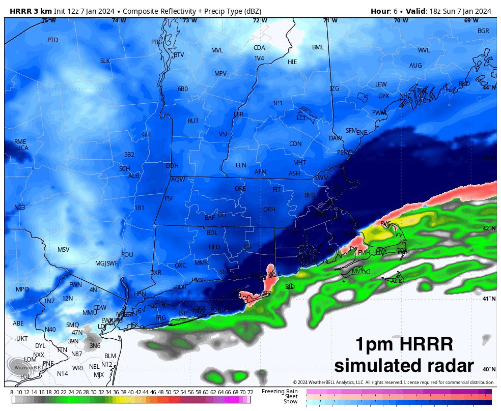
_________________
Mugs
AKA:King: Snow Weenie
Self Proclaimed
WINTER 2014-15 : 55.12" +.02 for 6 coatings (avg. 35")
WINTER 2015-16 Total - 29.8" (Avg 35")
WINTER 2016-17 : 39.5" so far

amugs- Advanced Forecaster - Mod

- Posts : 15095
Reputation : 213
Join date : 2013-01-07
Age : 54
Location : Hillsdale,NJ
 Re: JAN 6th-7th Storm Part II
Snow began again in Piscataway about 9:30AM. 34 degrees, light snow now(although there were some big flakes earlier).
JT33- Posts : 42
Reputation : 0
Join date : 2022-01-25
Location : Piscataway
 Re: JAN 6th-7th Storm Part II
It’s snowing here again. It’s really hard to say how much I got yesterday since I was not at home for much of the snow activity, and precip was mixed by the time I got home. I’m not sure if it ever went over to rain. Measuring now on my deck it’s 3.5” which is probably the best number I’m going to be able to get. NWS storm reports as of 7 am show measurements of around that amount in several nearby areas, but there were fewer reports than usual and the latest reports as of 9:35 am are mostly less than one inch in nearby areas, but that doesn’t make sense since it wasn’t snowing early this morning.
So I’ll go with 3.5” for yesterday, and maybe I will add to that at some point today.
So I’ll go with 3.5” for yesterday, and maybe I will add to that at some point today.
brownie- Posts : 393
Reputation : 17
Join date : 2013-11-10
Location : Parsippany, NJ
1190ftalt likes this post
 Re: JAN 6th-7th Storm Part II
dkodgis wrote:I snowblew out front. Sticking on the deck gave me 13 but the driveway had a bit less. Blowing snow I guess?
No it usually doesnt stick as fast and compresses quickly on blacktop which retains heat. You're most accurate would be on the deck or a concrete patio if you have one.
Most reports around you are 12-14. You're 13 is probably the most accurate.

CPcantmeasuresnow- Wx Statistician Guru

- Posts : 7274
Reputation : 230
Join date : 2013-01-07
Age : 103
Location : Eastern Orange County, NY
1190ftalt likes this post
 Re: JAN 6th-7th Storm Part II
Heavy snow here now.

docstox12- Wx Statistician Guru

- Posts : 8530
Reputation : 222
Join date : 2013-01-07
Age : 73
Location : Monroe NY
CPcantmeasuresnow and 1190ftalt like this post
Page 24 of 26 •  1 ... 13 ... 23, 24, 25, 26
Page 24 of 26
Permissions in this forum:
You cannot reply to topics in this forum|
|
|

 Home
Home
