
 Search
Long Range Thread 28.0
Page 12 of 18 •  1 ... 7 ... 11, 12, 13 ... 18
 ![]()
Re: Long Range Thread 28.0
![]() by billg315 Sat Feb 10, 2024 7:01 am
by billg315 Sat Feb 10, 2024 7:01 am
One other word of caution: if you use the models’ Positive Snowdepth Change maps instead of the 10:1 maps, the totals are lighter (ie 4-8” vs some of the double digit totals you’re seeing above on Euro and only a 1-3” on GFS except north of NJ). Keep that in the back of your head.
billg315- Advanced Forecaster - Mod

- Posts : 4483
Join date : 2015-01-24
kalleg likes this post
Re: Long Range Thread 28.0
![]() by billg315 Sat Feb 10, 2024 7:13 am
by billg315 Sat Feb 10, 2024 7:13 am
billg315- Advanced Forecaster - Mod
- Posts : 4483
Join date : 2015-01-24
Re: Long Range Thread 28.0
![]() by heehaw453 Sat Feb 10, 2024 7:30 am
by heehaw453 Sat Feb 10, 2024 7:30 am
1/Track of the mid-levels and ULL. Keep mid-levels crossing around Cape May and then ENE. ULL over the Delmarva
2/Close off mid-levels as it passes east of Cape May
Get those 2 things to occur this will be 6" no problem. If not then several inches still possible but won't be sig IMO.
06Z GFS was late on maturing the mid-levels.
heehaw453- Advanced Forecaster

- Posts : 3906
Reputation : 86
Join date : 2014-01-20
Location : Bedminster Township, PA Elevation 600' ASL
Re: Long Range Thread 28.0
![]() by Frank_Wx Sat Feb 10, 2024 7:43 am
by Frank_Wx Sat Feb 10, 2024 7:43 am
heehaw453 wrote:2 key ingredients.
1/Track of the mid-levels and ULL. Keep mid-levels crossing around Cape May and then ENE. ULL over the Delmarva
2/Close off mid-levels as it passes east of Cape May
Get those 2 things to occur this will be 6" no problem. If not then several inches still possible but won't be sig IMO.
06Z GFS was late on maturing the mid-levels.
One is most important. The ULL is likely to close off well before it gets to us. This causes heights along the coast to get a little too amplified which initially warms our boundary layers. The lack of HP or 50/50 hurts us. But you have other features like a dual upper level jet structure and partial phasing with the northern branch that create those dynamics and bring the cold air in. It’s a delicate situation for the coast. N&W is in a prime spot IMO
_________________
_______________________________________________________________________________________________________
CLICK HERE to view NJ Strong Snowstorm Classifications

Frank_Wx- Godzilla Seeker

- Posts : 21305
Reputation : 328
Join date : 2013-01-05
Age : 32
Location : Jersey City, NJ -

docstox12 and heehaw453 like this post
Re: Long Range Thread 28.0
![]() by heehaw453 Sat Feb 10, 2024 7:46 am
by heehaw453 Sat Feb 10, 2024 7:46 am
heehaw453- Advanced Forecaster
- Posts : 3906
Reputation : 86
Join date : 2014-01-20
Location : Bedminster Township, PA Elevation 600' ASL
Re: Long Range Thread 28.0
![]() by heehaw453 Sat Feb 10, 2024 7:54 am
by heehaw453 Sat Feb 10, 2024 7:54 am

heehaw453- Advanced Forecaster
- Posts : 3906
Reputation : 86
Join date : 2014-01-20
Location : Bedminster Township, PA Elevation 600' ASL
Re: Long Range Thread 28.0
![]() by Irish Sat Feb 10, 2024 8:57 am
by Irish Sat Feb 10, 2024 8:57 am
Irish wrote:So, I'm reading that we really need things to work out within the next 2 weeks in regard to winter weather, as the long range expected cold may not be materializing as hoped. After the possibility of a Presidents' Day storm, we may be done and truly looking at an early spring.
Is the reverse psychology working yet?

Irish- Pro Enthusiast

- Posts : 788
Reputation : 19
Join date : 2019-01-16
Age : 45
Location : Old Bridge, NJ
sroc4, docstox12, kalleg, essexcountypete and billg315 like this post
Re: Long Range Thread 28.0
![]() by Irish Sat Feb 10, 2024 10:46 am
by Irish Sat Feb 10, 2024 10:46 am
Irish- Pro Enthusiast
- Posts : 788
Reputation : 19
Join date : 2019-01-16
Age : 45
Location : Old Bridge, NJ
Re: Long Range Thread 28.0
![]() by heehaw453 Sat Feb 10, 2024 11:00 am
by heehaw453 Sat Feb 10, 2024 11:00 am
heehaw453 wrote:2 key ingredients.
1/Track of the mid-levels and ULL. Keep mid-levels crossing around Cape May and then ENE. ULL over the Delmarva
2/Close off mid-levels as it passes east of Cape May
Get those 2 things to occur this will be 6" no problem. If not then several inches still possible but won't be sig IMO.
06Z GFS was late on maturing the mid-levels.
It's going to be boom or bust with this system. 1 and 2 will determine if/who gets the 6"+. And slight variations will make all the difference.
heehaw453- Advanced Forecaster
- Posts : 3906
Reputation : 86
Join date : 2014-01-20
Location : Bedminster Township, PA Elevation 600' ASL
Re: Long Range Thread 28.0
![]() by heehaw453 Sat Feb 10, 2024 11:11 am
by heehaw453 Sat Feb 10, 2024 11:11 am
It's night and day with the Canadian GGEM with regard to the strength/maturity of the ULL.
The GFS has a mature ULL and the Canadian never gets there. All the difference. Caution is warranted regardless of what any model shows at 66 hours out. Boom or bust.


heehaw453- Advanced Forecaster
- Posts : 3906
Reputation : 86
Join date : 2014-01-20
Location : Bedminster Township, PA Elevation 600' ASL
Re: Long Range Thread 28.0
![]() by hyde345 Sat Feb 10, 2024 1:21 pm
by hyde345 Sat Feb 10, 2024 1:21 pm
Irish wrote:The cooler solutions seem like they're winning out at this current time for Tuesday. Starting to get a bit more pumped for a snowier outcome Monday night into Tuesday...
Huh? The GFS, Euro, and ICON all ticked north. It's basically the GFS/EURO/ICON vs the CMC/Ukie/Nam.

hyde345- Pro Enthusiast
- Posts : 1082
Reputation : 48
Join date : 2013-01-08
Location : Hyde Park, NY
Re: Long Range Thread 28.0
![]() by Irish Sat Feb 10, 2024 1:40 pm
by Irish Sat Feb 10, 2024 1:40 pm
Just happened to see TWC forecast temps dropped and now show all snow versus a mix on Tuesday.hyde345 wrote:Irish wrote:The cooler solutions seem like they're winning out at this current time for Tuesday. Starting to get a bit more pumped for a snowier outcome Monday night into Tuesday...
Huh? The GFS, Euro, and ICON all ticked north. It's basically the GFS/EURO/ICON vs the CMC/Ukie/Nam.
Irish- Pro Enthusiast
- Posts : 788
Reputation : 19
Join date : 2019-01-16
Age : 45
Location : Old Bridge, NJ
Re: Long Range Thread 28.0
![]() by hyde345 Sat Feb 10, 2024 1:53 pm
by hyde345 Sat Feb 10, 2024 1:53 pm
Irish wrote:Just happened to see TWC forecast temps dropped and now show all snow versus a mix on Tuesday.hyde345 wrote:Irish wrote:The cooler solutions seem like they're winning out at this current time for Tuesday. Starting to get a bit more pumped for a snowier outcome Monday night into Tuesday...
Huh? The GFS, Euro, and ICON all ticked north. It's basically the GFS/EURO/ICON vs the CMC/Ukie/Nam.
That may change again.
hyde345- Pro Enthusiast
- Posts : 1082
Reputation : 48
Join date : 2013-01-08
Location : Hyde Park, NY
dkodgis likes this post
Re: Long Range Thread 28.0
![]() by Irish Sat Feb 10, 2024 2:07 pm
by Irish Sat Feb 10, 2024 2:07 pm
I'm sure it will with it only being Saturday and the storm coming through on Monday night.hyde345 wrote:Irish wrote:Just happened to see TWC forecast temps dropped and now show all snow versus a mix on Tuesday.hyde345 wrote:Irish wrote:The cooler solutions seem like they're winning out at this current time for Tuesday. Starting to get a bit more pumped for a snowier outcome Monday night into Tuesday...
Huh? The GFS, Euro, and ICON all ticked north. It's basically the GFS/EURO/ICON vs the CMC/Ukie/Nam.
That may change again.
Irish- Pro Enthusiast
- Posts : 788
Reputation : 19
Join date : 2019-01-16
Age : 45
Location : Old Bridge, NJ
Re: Long Range Thread 28.0
![]() by Dunnzoo Sat Feb 10, 2024 4:42 pm
by Dunnzoo Sat Feb 10, 2024 4:42 pm
_________________
Janet
Snowfall winter of 2023-2024 17.5"
Snowfall winter of 2022-2023 6.0"
Snowfall winter of 2021-2022 17.6" 1" sleet 2/25/22
Snowfall winter of 2020-2021 51.1"
Snowfall winter of 2019-2020 8.5"
Snowfall winter of 2018-2019 25.1"
Snowfall winter of 2017-2018 51.9"
Snowfall winter of 2016-2017 45.6"
Snowfall winter of 2015-2016 29.5"
Snowfall winter of 2014-2015 50.55"
Snowfall winter of 2013-2014 66.5"

Dunnzoo- Senior Enthusiast - Mod
- Posts : 4905
Reputation : 68
Join date : 2013-01-11
Age : 62
Location : Westwood, NJ
Re: Long Range Thread 28.0
![]() by Irish Sat Feb 10, 2024 10:43 pm
by Irish Sat Feb 10, 2024 10:43 pm
Irish- Pro Enthusiast
- Posts : 788
Reputation : 19
Join date : 2019-01-16
Age : 45
Location : Old Bridge, NJ
weatherwatchermom likes this post
Re: Long Range Thread 28.0
![]() by sroc4 Sun Feb 11, 2024 7:58 am
by sroc4 Sun Feb 11, 2024 7:58 am
Dunnzoo wrote:You can all continue this discussion on the new thread made for this week... I keep thinking someone saw something for down the road
Speaking of something down the road looks like 17th-20th is next period to monitor. This has the look of a big storm with -EPO, -AO, and -NAO look. It’s 200+ hrs out so time for evolution. All we look for at the range is pattern recognition. This look here is definitely conducive to a big winter storm.

_________________
"In weather and in life, there's no winning and losing; there's only winning and learning."
WINTER 2012/2013 TOTALS 43.65"WINTER 2017/2018 TOTALS 62.85" WINTER 2022/2023 TOTALS 4.9"
WINTER 2013/2014 TOTALS 64.85"WINTER 2018/2019 TOTALS 14.25" WINTER 2023/2024 TOTALS 13.1"
WINTER 2014/2015 TOTALS 71.20"WINTER 2019/2020 TOTALS 6.35"
WINTER 2015/2016 TOTALS 35.00"WINTER 2020/2021 TOTALS 37.75"
WINTER 2016/2017 TOTALS 42.25"WINTER 2021/2022 TOTALS 31.65"

sroc4- Admin
- Posts : 8354
Reputation : 302
Join date : 2013-01-07
Location : Wading River, LI
kalleg, jmanley32, Irish and phil155 like this post
Re: Long Range Thread 28.0
![]() by SENJsnowman Tue Feb 13, 2024 1:42 pm
by SENJsnowman Tue Feb 13, 2024 1:42 pm
sroc4 wrote:Dunnzoo wrote:You can all continue this discussion on the new thread made for this week... I keep thinking someone saw something for down the road
Speaking of something down the road looks like 17th-20th is next period to monitor. This has the look of a big storm with -EPO, -AO, and -NAO look. It’s 200+ hrs out so time for evolution. All we look for at the range is pattern recognition. This look here is definitely conducive to a big winter storm.
Alright, that was fun!! Now, how’s the weekend looking?

SENJsnowman- Senior Enthusiast

- Posts : 1189
Reputation : 61
Join date : 2017-01-06
Age : 51
Location : Bayville, NJ
Re: Long Range Thread 28.0
![]() by amugs Tue Feb 13, 2024 1:52 pm
by amugs Tue Feb 13, 2024 1:52 pm

_________________
Mugs
AKA:King: Snow Weenie
Self Proclaimed
WINTER 2014-15 : 55.12" +.02 for 6 coatings (avg. 35")
WINTER 2015-16 Total - 29.8" (Avg 35")
WINTER 2016-17 : 39.5" so far

amugs- Advanced Forecaster - Mod
- Posts : 15095
Reputation : 213
Join date : 2013-01-07
Age : 54
Location : Hillsdale,NJ
SENJsnowman likes this post
Re: Long Range Thread 28.0
![]() by Irish Tue Feb 13, 2024 2:21 pm
by Irish Tue Feb 13, 2024 2:21 pm
Irish- Pro Enthusiast
- Posts : 788
Reputation : 19
Join date : 2019-01-16
Age : 45
Location : Old Bridge, NJ
Re: Long Range Thread 28.0
![]() by CPcantmeasuresnow Tue Feb 13, 2024 2:23 pm
by CPcantmeasuresnow Tue Feb 13, 2024 2:23 pm
sroc4 wrote:Dunnzoo wrote:You can all continue this discussion on the new thread made for this week... I keep thinking someone saw something for down the road
Speaking of something down the road looks like 17th-20th is next period to monitor. This has the look of a big storm with -EPO, -AO, and -NAO look. It’s 200+ hrs out so time for evolution. All we look for at the range is pattern recognition. This look here is definitely conducive to a big winter storm.
Start a thread, you're our hot hand LOL.

CPcantmeasuresnow- Wx Statistician Guru

- Posts : 7274
Reputation : 230
Join date : 2013-01-07
Age : 103
Location : Eastern Orange County, NY
docstox12 and dkodgis like this post
Re: Long Range Thread 28.0
![]() by heehaw453 Tue Feb 13, 2024 2:53 pm
by heehaw453 Tue Feb 13, 2024 2:53 pm

heehaw453- Advanced Forecaster
- Posts : 3906
Reputation : 86
Join date : 2014-01-20
Location : Bedminster Township, PA Elevation 600' ASL
Re: Long Range Thread 28.0
![]() by SENJsnowman Tue Feb 13, 2024 3:00 pm
by SENJsnowman Tue Feb 13, 2024 3:00 pm
heehaw453 wrote:I'll be travelling over President's Day weekend so count on snow. Definitely want to cash in with this pattern and it might continue with a clipper on Thursday night. Anyone that thinks that clipper is harmless and passes well north have a look at the Atlantic and think again. MUCH better airmass for coastal plain folks. You will be trying to cash in on on each wave with this pattern. Now is the time for GREED. Go big or go home.
Well, if that update don’t get a snow-loving Coastie all in the Valentine’s Day mood, nothing will!!

SENJsnowman- Senior Enthusiast
- Posts : 1189
Reputation : 61
Join date : 2017-01-06
Age : 51
Location : Bayville, NJ
kalleg and weatherwatchermom like this post
Re: Long Range Thread 28.0
![]() by Irish Tue Feb 13, 2024 3:02 pm
by Irish Tue Feb 13, 2024 3:02 pm
Other than you mentioning it, I haven't seen anything for Thursday night.heehaw453 wrote:I'll be travelling over President's Day weekend so count on snow. Definitely want to cash in with this pattern and it might continue with a clipper on Thursday night. Anyone that thinks that clipper is harmless and passes well north have a look at the Atlantic and think again. MUCH better airmass for coastal plain folks. You will be trying to cash in on on each wave with this pattern. Now is the time for GREED. Go big or go home.
Thoughts for the Friday into Saturday system?
Irish- Pro Enthusiast
- Posts : 788
Reputation : 19
Join date : 2019-01-16
Age : 45
Location : Old Bridge, NJ
Re: Long Range Thread 28.0
![]() by heehaw453 Tue Feb 13, 2024 3:11 pm
by heehaw453 Tue Feb 13, 2024 3:11 pm
Irish wrote:Other than you mentioning it, I haven't seen anything for Thursday night.heehaw453 wrote:I'll be travelling over President's Day weekend so count on snow. Definitely want to cash in with this pattern and it might continue with a clipper on Thursday night. Anyone that thinks that clipper is harmless and passes well north have a look at the Atlantic and think again. MUCH better airmass for coastal plain folks. You will be trying to cash in on on each wave with this pattern. Now is the time for GREED. Go big or go home.
Thoughts for the Friday into Saturday system?
A relaxing NAM state should pique interest. We see times when the AO/NAO start relaxing that s/w's can lift further north and strengthen.
What stands out to me is the n/s activeness and a southern stream underneath it. Look at the TPV in Hudson Bay dropping energy on a very steep ridge. If you time that right big snowstorm right to the coast.

heehaw453- Advanced Forecaster
- Posts : 3906
Reputation : 86
Join date : 2014-01-20
Location : Bedminster Township, PA Elevation 600' ASL
SENJsnowman and Irish like this post
Re: Long Range Thread 28.0
![]() by Irish Tue Feb 13, 2024 3:27 pm
by Irish Tue Feb 13, 2024 3:27 pm
Irish- Pro Enthusiast
- Posts : 788
Reputation : 19
Join date : 2019-01-16
Age : 45
Location : Old Bridge, NJ
MattyICE likes this post
Re: Long Range Thread 28.0
![]() by amugs Tue Feb 13, 2024 4:53 pm
by amugs Tue Feb 13, 2024 4:53 pm
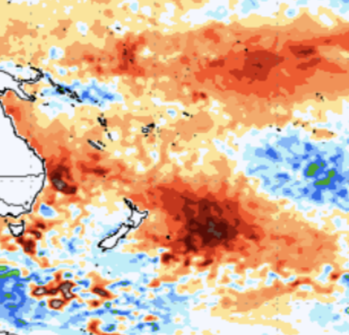
Look at these hot spots off New Zealand and Eastern Australia. 3C above normal!! What's causing it?? Underwater Volcanoes some have surmised and it is a very plausible answer for how warm and fast it has become since September.
_________________
Mugs
AKA:King: Snow Weenie
Self Proclaimed
WINTER 2014-15 : 55.12" +.02 for 6 coatings (avg. 35")
WINTER 2015-16 Total - 29.8" (Avg 35")
WINTER 2016-17 : 39.5" so far
amugs- Advanced Forecaster - Mod
- Posts : 15095
Reputation : 213
Join date : 2013-01-07
Age : 54
Location : Hillsdale,NJ
docstox12 likes this post
Page 12 of 18 • 1 ... 7 ... 11, 12, 13 ... 18 ![]()
|
|
|