Long Range Thread 28.0
+33
weatherwatchermom
essexcountypete
skinsfan1177
aiannone
larryrock72
Coachgriff
DAYBLAZER
nutleyblizzard
hyde345
docstox12
CPcantmeasuresnow
frank 638
Koroptim
HectorO
billg315
dkodgis
MattyICE
toople
sroc4
rb924119
Grselig
crippo84
phil155
Frank_Wx
jmanley32
NJBear
tomsriversnowstorm
Carvin
heehaw453
SENJsnowman
Irish
amugs
richb521
37 posters
Page 11 of 18
Page 11 of 18 •  1 ... 7 ... 10, 11, 12 ... 14 ... 18
 Re: Long Range Thread 28.0
18z GFS didn't change much from earlier. Maybe a tick south again if anything. The Euro and GFS have pretty much settled in for the last 24 hours with the Euro just a bit more north and a little less snowy than the GFS. At this point I'm anxious to see how the NAM weighs in tomorrow and Sunday.
billg315- Advanced Forecaster - Mod

- Posts : 4483
Join date : 2015-01-24
 Re: Long Range Thread 28.0
heehaw453 wrote:The other thing too to point out. A bad track will mix. I don't care what the antecedent air mass is. What a good high pressure does (which we don't have here) is create a bit more resistance. But a too amped up low pressure will cut it through it like butter at the mid-levels. It always track first then everything else IMO. No difference here.
Agree with this 100%. I've been meaning to comment on this earlier today in a slightly different context but closely related. I think it's important for folks to understand that most of these close-call winter storms are heavily track-driven rather than solely temperature regime driven. So you can't solely look at the temperatures the day before, or the forecast temperature in a model that shows rain at that moment and say it will be "too warm for snow," etc etc. because the right track and right dynamics very often create their own cold air in most of these storms. If you are seeing warm forecast temps in your forecast app, it's usually because the model is at that time anticipating a warm-favoring storm TRACK/DYNAMICS. You will notice the forecast temp on your app will change to colder temps if the models start to show the storm track/dynamics changing.
For example: If a storm cuts to our west, or directly over us, more often than not it's going to be rain (or snow to mix to rain) even if cold air is in place. If it's to our south and east and a cold air source is available, more often than not someone is getting some snow even if its warm the day before. Usually, IMO, especially in the heart of winter, the storm determines the temperature more than the temperature determining the storm. This is how in March you can get a 55 degree day followed by a blizzard the next day.
Now there are exceptions to every rule, and there are absolutely times where a warm antecedent air mass will make it harder to get snow (especially in over-running events, or with weaker storm systems, or borderline storm tracks) so I don't discount the value of having cold air in place. Trust me, I'd rather have cold air in place AND a good track.
But more often than not I'd rather have a good track with marginal temperatures at the start than a bad track with colder temps at the start.
billg315- Advanced Forecaster - Mod

- Posts : 4483
Join date : 2015-01-24
docstox12, kalleg, heehaw453, SENJsnowman and JT33 like this post
 Re: Long Range Thread 28.0
billg315 wrote:Lol. Wow. Didn't bother to read the article. Any use of the word "snowmageddon" (which probably shouldn't be used in any storm/pattern as it's rather silly) with this storm or this pattern is laughable.
As I said earlier today, I'll be happy to get a few inches out of this storm. Thrilled if more, not shocked if less. Beyond that, while there is some cold air coming, I don't see any signs (yet) of any blockbuster storms in the next week or so.
I laughed

weatherwatchermom- Senior Enthusiast

- Posts : 3793
Reputation : 78
Join date : 2014-11-25
Location : Hazlet Township, NJ
docstox12 and billg315 like this post
 Re: Long Range Thread 28.0
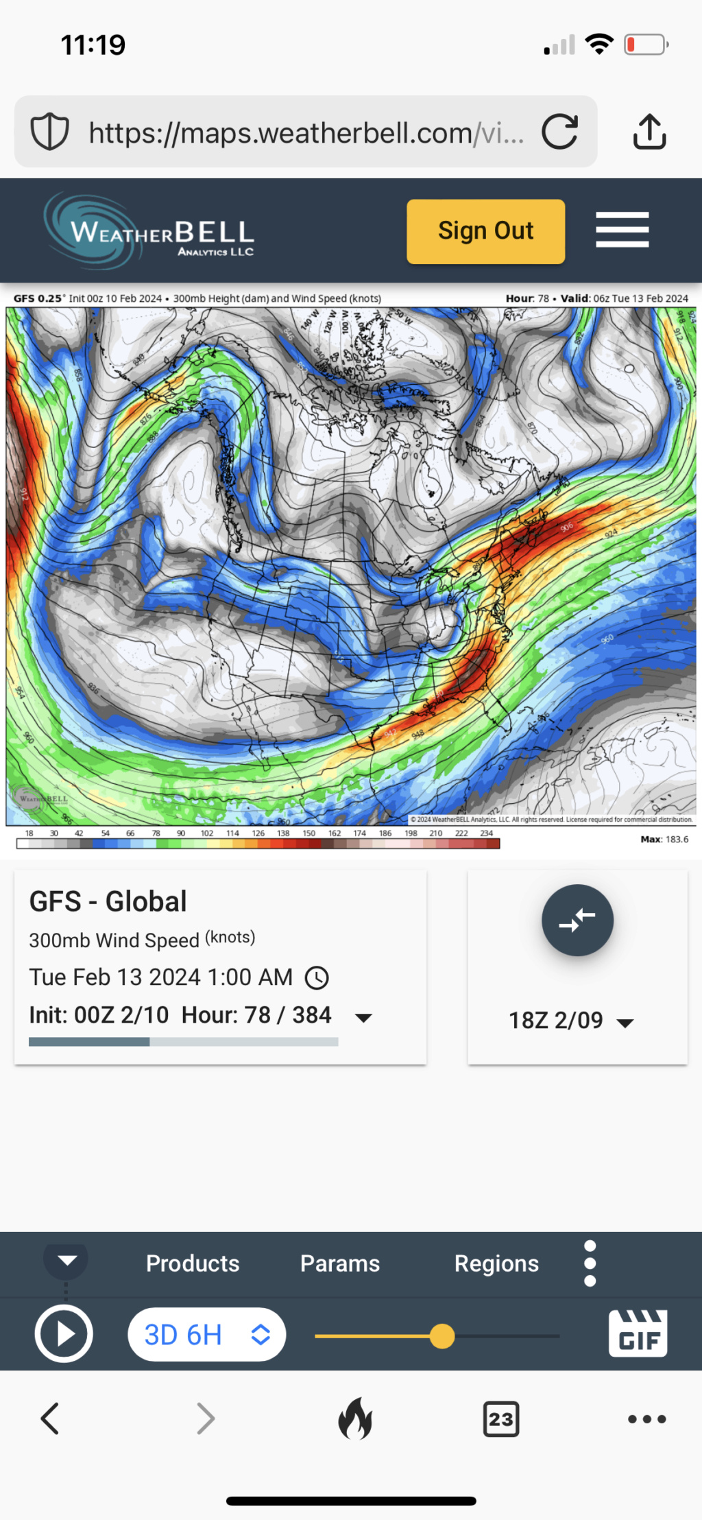
18Z Euro control. This is essentially similar to the operational. This track would be very favorable for the I95 TTN to NYC. It's literally going to come down to exactly how strong the storm is as it makes it's transfer. Weaker approach it's southerly flow ahead is muted. Strong it's enhanced. But what i continue to notice it's the confluence, but what adds to the transfer is the n/s acting as a kicker. That's why it moves so quickly ENE. The bottom gif it's almost like a pool stick hitting a ball.
heehaw453- Advanced Forecaster

- Posts : 3906
Reputation : 86
Join date : 2014-01-20
Location : Bedminster Township, PA Elevation 600' ASL
 Re: Long Range Thread 28.0
The Goldilocks solution would be where we continue to amp the shortwave but simultaneously continue to trend positively with more of a confluence press from the lead/northern stream short wave. That would not do a ton to slow this storm down but it would really enhance precip on that zone where the squeeze is strongest. No idea where that happens but I don’t think this thing gains a ton of latitude and where this zone sets up some impressive lift and associated rates easily overcome the less than stellar antecedent air mass.
MattyICE- Advanced Forecaster

- Posts : 249
Reputation : 6
Join date : 2017-11-10
Age : 38
Location : Clifton, NJ (Eastern Passaic County)
heehaw453 likes this post

nutleyblizzard- Senior Enthusiast

- Posts : 1954
Reputation : 41
Join date : 2014-01-30
Age : 58
Location : Nutley, new jersey
kalleg, jmanley32, frank 638 and MattyICE like this post
heehaw453- Advanced Forecaster

- Posts : 3906
Reputation : 86
Join date : 2014-01-20
Location : Bedminster Township, PA Elevation 600' ASL
MattyICE likes this post
 Re: Long Range Thread 28.0
NAM not fully in-range yet, but if I had to bet based on what I see in the 0z run, once we get it in range tomorrow AM it is going to be leaning toward a cold and snowy output. At least in the early runs tomorrow. I like the Low placement and temp profiles in the 0z.

billg315- Advanced Forecaster - Mod

- Posts : 4483
Reputation : 185
Join date : 2015-01-24
Age : 50
Location : Flemington, NJ
heehaw453 likes this post
 Re: Long Range Thread 28.0
billg315 wrote:NAM not fully in-range yet, but if I had to bet based on what I see in the 0z run, once we get it in range tomorrow AM it is going to be leaning toward a cold and snowy output. At least in the early runs tomorrow. I like the Low placement and temp profiles in the 0z.
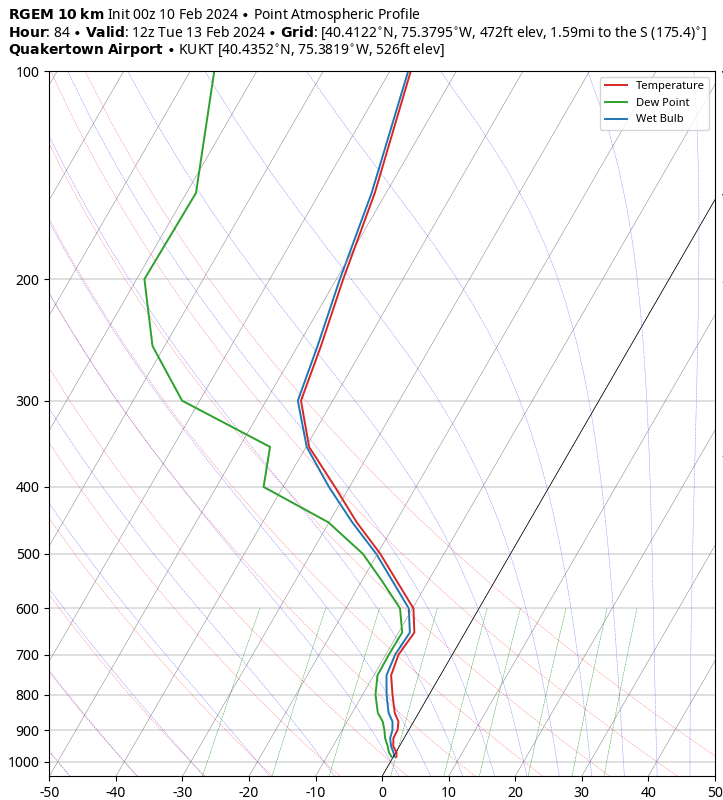
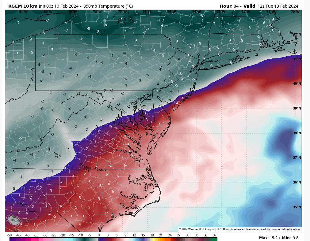
Agree. I like seeing 00Z RGEM on the colder side too. If we can hold that meso I'd be encouraged for a decent thermal profile.
heehaw453- Advanced Forecaster

- Posts : 3906
Reputation : 86
Join date : 2014-01-20
Location : Bedminster Township, PA Elevation 600' ASL
billg315 likes this post
 Re: Long Range Thread 28.0
NWS went colder up by me in LHV now all snow Monday night to 1 pm Tuesday.Things getting interesting!!

docstox12- Wx Statistician Guru

- Posts : 8530
Reputation : 222
Join date : 2013-01-07
Age : 73
Location : Monroe NY
kalleg, dkodgis, heehaw453 and SENJsnowman like this post
 Re: Long Range Thread 28.0
RGEM resembles the NAM. Low transfers off the VA Capes!

nutleyblizzard- Senior Enthusiast

- Posts : 1954
Reputation : 41
Join date : 2014-01-30
Age : 58
Location : Nutley, new jersey
docstox12 and MattyICE like this post
 Re: Long Range Thread 28.0
00z GFS coming in…
_________________
_______________________________________________________________________________________________________
CLICK HERE to view NJ Strong Snowstorm Classifications
 Re: Long Range Thread 28.0
_________________
_______________________________________________________________________________________________________
CLICK HERE to view NJ Strong Snowstorm Classifications
 Re: Long Range Thread 28.0
_________________
_______________________________________________________________________________________________________
CLICK HERE to view NJ Strong Snowstorm Classifications
docstox12 and kalleg like this post
 Re: Long Range Thread 28.0
CMC is a crusher!

nutleyblizzard- Senior Enthusiast

- Posts : 1954
Reputation : 41
Join date : 2014-01-30
Age : 58
Location : Nutley, new jersey
heehaw453 likes this post
heehaw453- Advanced Forecaster

- Posts : 3906
Reputation : 86
Join date : 2014-01-20
Location : Bedminster Township, PA Elevation 600' ASL

docstox12- Wx Statistician Guru

- Posts : 8530
Reputation : 222
Join date : 2013-01-07
Age : 73
Location : Monroe NY

nutleyblizzard- Senior Enthusiast

- Posts : 1954
Reputation : 41
Join date : 2014-01-30
Age : 58
Location : Nutley, new jersey
 Re: Long Range Thread 28.0
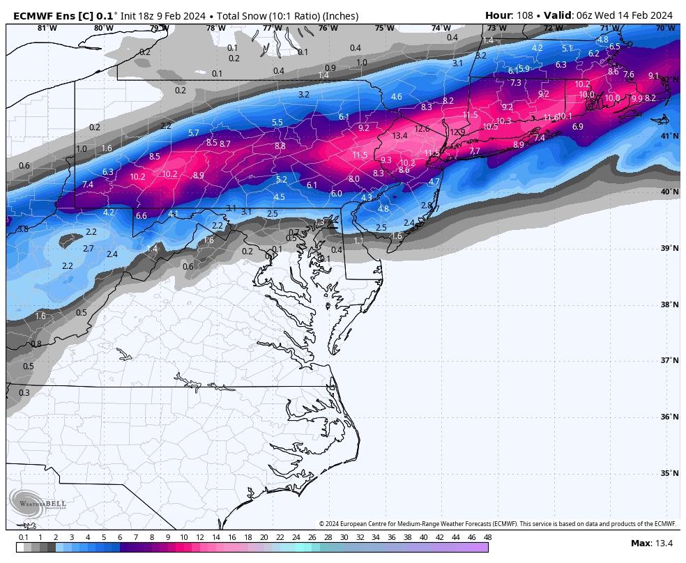
This is enticing to bite onto but Ima hold for now, even the 00z GFS was decent for IMBY verbatim, a 6 inche storm would be great the Euro above would be incredible and would make up for the past 2 years!

jmanley32- Senior Enthusiast

- Posts : 20535
Reputation : 108
Join date : 2013-12-12
Age : 43
Location : Yonkers, NY
 Re: Long Range Thread 28.0
_________________
"In weather and in life, there's no winning and losing; there's only winning and learning."
WINTER 2012/2013 TOTALS 43.65"WINTER 2017/2018 TOTALS 62.85" WINTER 2022/2023 TOTALS 4.9"
WINTER 2013/2014 TOTALS 64.85"WINTER 2018/2019 TOTALS 14.25" WINTER 2023/2024 TOTALS 13.1"
WINTER 2014/2015 TOTALS 71.20"WINTER 2019/2020 TOTALS 6.35"
WINTER 2015/2016 TOTALS 35.00"WINTER 2020/2021 TOTALS 37.75"
WINTER 2016/2017 TOTALS 42.25"WINTER 2021/2022 TOTALS 31.65"

sroc4- Admin

- Posts : 8354
Reputation : 302
Join date : 2013-01-07
Location : Wading River, LI
Judy Margolis and jmanley32 like this post
 Re: Long Range Thread 28.0
I know it is still to far off scott but what do you think the nyc metro area sees a big snowstorm? More specifically how much is the warm ground and lack of leading up cold going to put a possible damper on this for me and many others?

jmanley32- Senior Enthusiast

- Posts : 20535
Reputation : 108
Join date : 2013-12-12
Age : 43
Location : Yonkers, NY
 Re: Long Range Thread 28.0
Yes. That's why the h5 -EPO had me excited. That AK ridge facilitates that extra energy coming down the slide. It's just a matter of keeping it at the right latitude. The h5 is aligned well for a decent event in many facets. But still need that luck to make the magic happen. Still on the fence personally.
heehaw453- Advanced Forecaster

- Posts : 3906
Reputation : 86
Join date : 2014-01-20
Location : Bedminster Township, PA Elevation 600' ASL
sroc4 likes this post

nutleyblizzard- Senior Enthusiast

- Posts : 1954
Reputation : 41
Join date : 2014-01-30
Age : 58
Location : Nutley, new jersey

nutleyblizzard- Senior Enthusiast

- Posts : 1954
Reputation : 41
Join date : 2014-01-30
Age : 58
Location : Nutley, new jersey
 Re: Long Range Thread 28.0
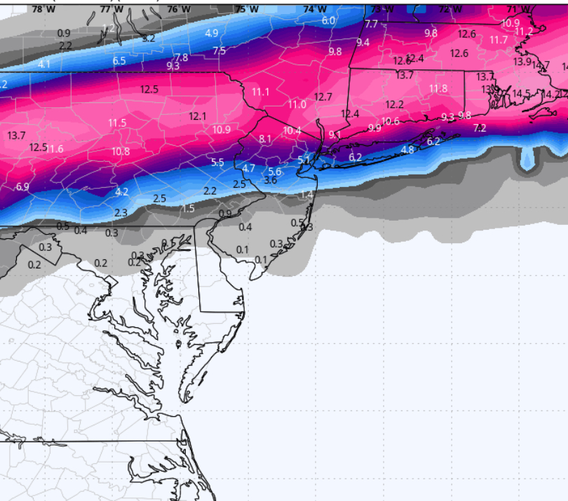
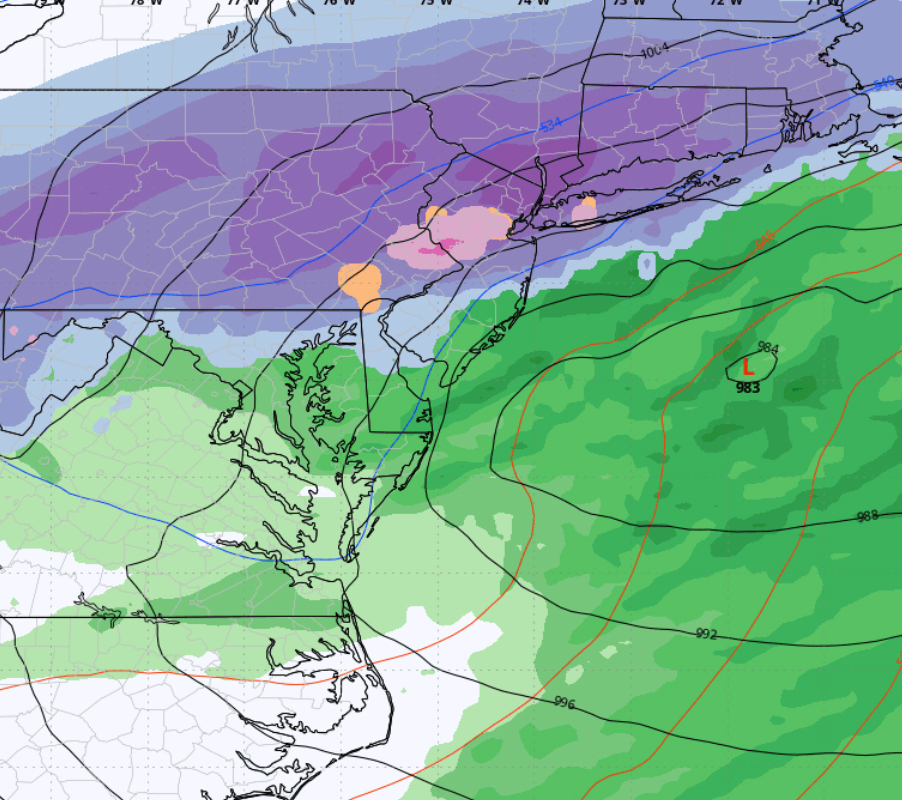
Morning roundup:
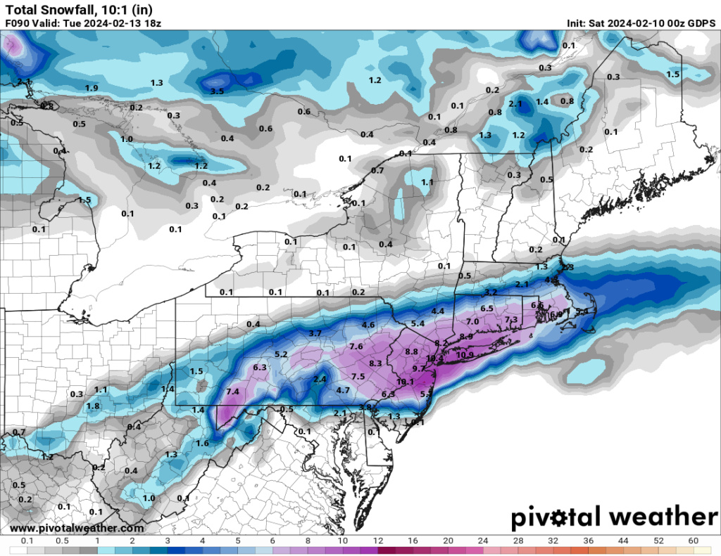
6z NAM just coming into range so these totals are cut short as we don’t have full storm output:
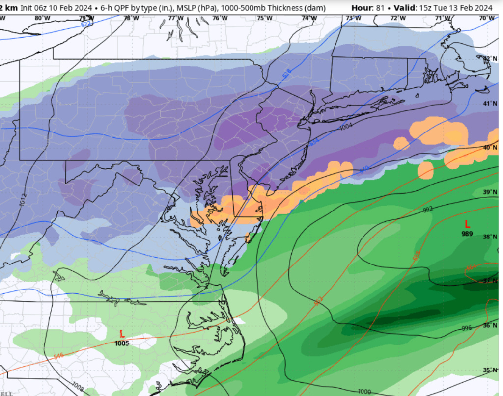
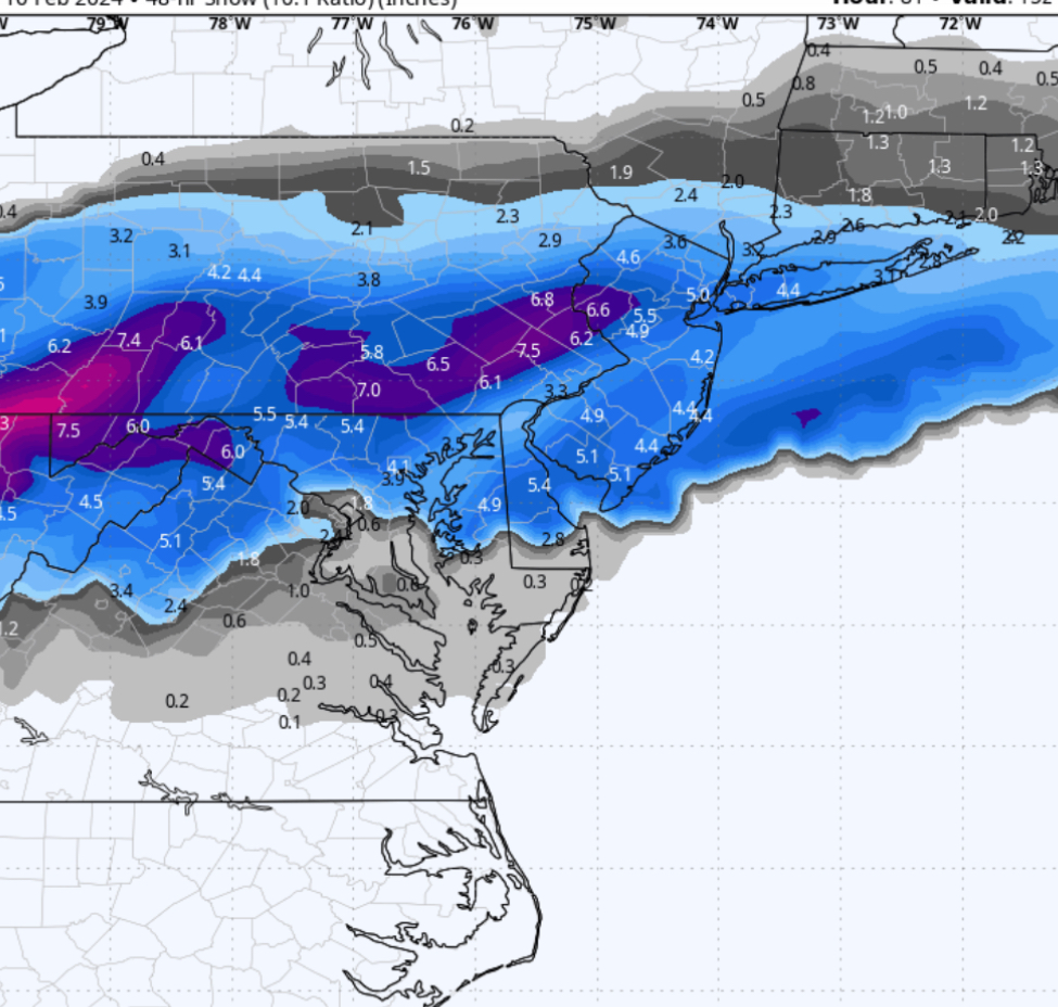
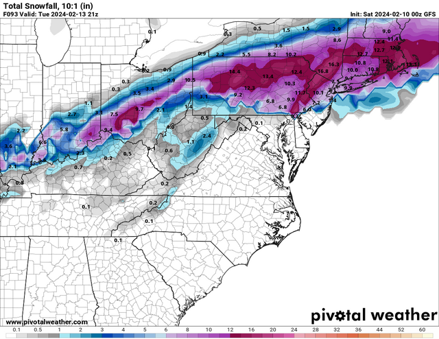
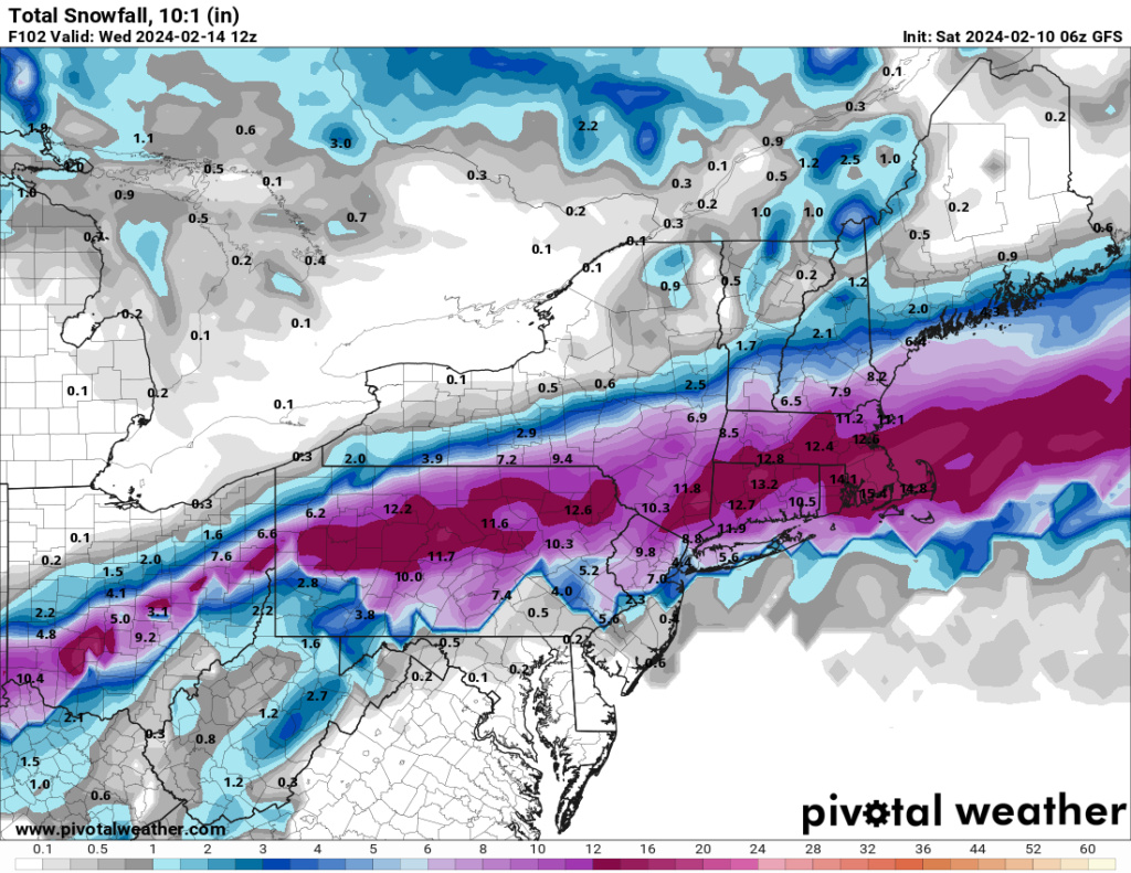
6z GFS is not as good as last night but still generally in the same spot:

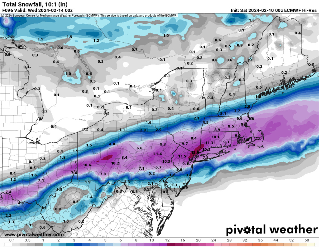
0z Euro (ironically after being way north 3 days ago has come so far south it now brings heaviest snow a bit further south than the GFS:

6z NAM just coming into range so these totals are cut short as we don’t have full storm output:


6z GFS is not as good as last night but still generally in the same spot:


0z Euro (ironically after being way north 3 days ago has come so far south it now brings heaviest snow a bit further south than the GFS:


billg315- Advanced Forecaster - Mod

- Posts : 4483
Reputation : 185
Join date : 2015-01-24
Age : 50
Location : Flemington, NJ
 Re: Long Range Thread 28.0
Both the Euro and GFS present mixing issues for some spots. NAM since last night seems colder perhaps why it’s not showing mixing at end of its run (which is a few hours short of storm’s end).
One other word of caution: if you use the models’ Positive Snowdepth Change maps instead of the 10:1 maps, the totals are lighter (ie 4-8” vs some of the double digit totals you’re seeing above on Euro and only a 1-3” on GFS except north of NJ). Keep that in the back of your head.
One other word of caution: if you use the models’ Positive Snowdepth Change maps instead of the 10:1 maps, the totals are lighter (ie 4-8” vs some of the double digit totals you’re seeing above on Euro and only a 1-3” on GFS except north of NJ). Keep that in the back of your head.

billg315- Advanced Forecaster - Mod

- Posts : 4483
Reputation : 185
Join date : 2015-01-24
Age : 50
Location : Flemington, NJ
kalleg likes this post
 Re: Long Range Thread 28.0
6z Euro now in. Not significantly different than 0z run from a quick glance. If anything a bit stronger on snow totals.

billg315- Advanced Forecaster - Mod

- Posts : 4483
Reputation : 185
Join date : 2015-01-24
Age : 50
Location : Flemington, NJ
Page 11 of 18 •  1 ... 7 ... 10, 11, 12 ... 14 ... 18
Page 11 of 18
Permissions in this forum:
You cannot reply to topics in this forum|
|
|

 Home
Home