Grading 2023-2024 meteorological winter
+5
SENJsnowman
billg315
docstox12
nutleyblizzard
heehaw453
9 posters
 Grading 2023-2024 meteorological winter
I label this winter the winter of more of the same...
In November I was concerned that eastern Canada/NNE was very slow to gain snowpack due to anomalous warmth. Once December recorded negligible snow that basically gave me a lot of confidence for BN to significantly BN snowfall for the meteorological winter. IMO when colder outbreaks and snowfall start in the area for December that's the atmosphere giving a good signal it's primed for winter weather.
Lack of snow in NNE comments
Historical snowfall when Central Park receives no snowfall in December
El Ninos tend to be back half loaded winters and this was a basin wide strong El Nino. Problem is it's not as simple as that. There are too many other variables that dictate the effect of the El Nino. Statistics deals with multivariate analysis and the weather is no different as it's a combination of variables and their effects/weights which is extremely complex. MEI tries to look at other factors but even that our understanding of the long term effects is limited. I have confidence AI using LLM and increasing/varying the parameters of the models will catapult long range forecasting in the next 20 years similar to what satellites did in the 1950's. It will require higher fidelity and more continuous data though meaning more infrastructure in the far reaches of the oceans, arctic, etc.
Let's take month by month...
December
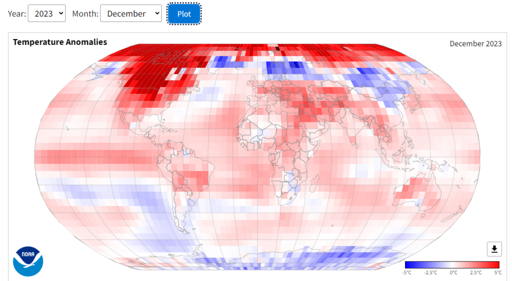
Not much to say. Canada was record breaking warmth and snowfall into NNE was very slow. No cross polar flow to cool the western hemisphere due to +EPO persistent Alaska trough. Consequently very little if any snowfall across the entire region. Temps averaged about 3.5-6+ AN across the area.
Grade F

January
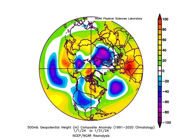
Better. Some evidence of cross polar flow with -EPO for a couple of weeks. Snowfall ranged from 10-15" NW of I95 to a few to several inches around NYC. NW of I95 snow cover lasted over 1 week. Temps averaged about 2-3.5 AN across the area.
Grade C-

February
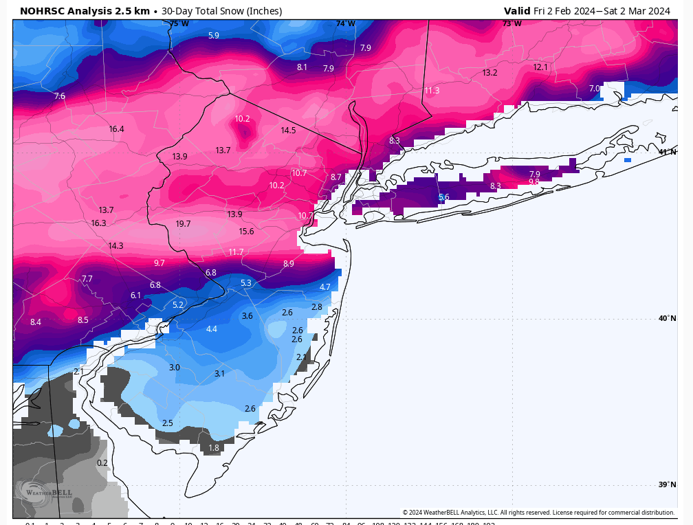
After burning first 11 days of the month the pattern flipped to more favorable. What stopped this month from producing much better was a big Omega block which shunted a major snow storm that wound up giving Nova Scotia feet of snow in a generational blizzard during first week of February. Those on social media calling for 2010 like February and 5+ weeks of a favorable pattern were over zealous. This month was about hitting the window in a 10 days period. If you did hit that it was good for your area and if not probably disappointing. IMBY I got 16" with 10+ days of snow cover that is a good month regardless of the first 11 days. Temps across the area averaged 3-4.5 AN
Grade B-

Seasonal snowfall to date

What happened with this winter? For starters we never really did get a long lasting NAO block and models were too aggressive with depicting that especially in February. That coupled with the usual inability to have a consistently favorable EPO allowed temps to be above normal for each month. The reality is there was about 20-25 days of the meteorological winter that had a serviceable pattern that's less the 33% of the winter. This is very consistent with what we've seen the past 9 years in these parts. So it's really more of the same until it's not. Tune in next year to see if that changes. At this point Nino/Nina makes no difference to me until I start observing a winter that actually is a winter.
Overall grade
D+/C-
In November I was concerned that eastern Canada/NNE was very slow to gain snowpack due to anomalous warmth. Once December recorded negligible snow that basically gave me a lot of confidence for BN to significantly BN snowfall for the meteorological winter. IMO when colder outbreaks and snowfall start in the area for December that's the atmosphere giving a good signal it's primed for winter weather.
Lack of snow in NNE comments
Historical snowfall when Central Park receives no snowfall in December
El Ninos tend to be back half loaded winters and this was a basin wide strong El Nino. Problem is it's not as simple as that. There are too many other variables that dictate the effect of the El Nino. Statistics deals with multivariate analysis and the weather is no different as it's a combination of variables and their effects/weights which is extremely complex. MEI tries to look at other factors but even that our understanding of the long term effects is limited. I have confidence AI using LLM and increasing/varying the parameters of the models will catapult long range forecasting in the next 20 years similar to what satellites did in the 1950's. It will require higher fidelity and more continuous data though meaning more infrastructure in the far reaches of the oceans, arctic, etc.
Let's take month by month...
December
Not much to say. Canada was record breaking warmth and snowfall into NNE was very slow. No cross polar flow to cool the western hemisphere due to +EPO persistent Alaska trough. Consequently very little if any snowfall across the entire region. Temps averaged about 3.5-6+ AN across the area.
Grade F


January
Better. Some evidence of cross polar flow with -EPO for a couple of weeks. Snowfall ranged from 10-15" NW of I95 to a few to several inches around NYC. NW of I95 snow cover lasted over 1 week. Temps averaged about 2-3.5 AN across the area.
Grade C-


February
After burning first 11 days of the month the pattern flipped to more favorable. What stopped this month from producing much better was a big Omega block which shunted a major snow storm that wound up giving Nova Scotia feet of snow in a generational blizzard during first week of February. Those on social media calling for 2010 like February and 5+ weeks of a favorable pattern were over zealous. This month was about hitting the window in a 10 days period. If you did hit that it was good for your area and if not probably disappointing. IMBY I got 16" with 10+ days of snow cover that is a good month regardless of the first 11 days. Temps across the area averaged 3-4.5 AN
Grade B-


Seasonal snowfall to date

What happened with this winter? For starters we never really did get a long lasting NAO block and models were too aggressive with depicting that especially in February. That coupled with the usual inability to have a consistently favorable EPO allowed temps to be above normal for each month. The reality is there was about 20-25 days of the meteorological winter that had a serviceable pattern that's less the 33% of the winter. This is very consistent with what we've seen the past 9 years in these parts. So it's really more of the same until it's not. Tune in next year to see if that changes. At this point Nino/Nina makes no difference to me until I start observing a winter that actually is a winter.
Overall grade
D+/C-
heehaw453- Advanced Forecaster

- Posts : 3906
Reputation : 86
Join date : 2014-01-20
Location : Bedminster Township, PA Elevation 600' ASL
sroc4, CPcantmeasuresnow, kalleg, brownie, billg315 and JT33 like this post
 Re: Grading 2023-2024 meteorological winter
I would grade this winter as a solid D-. I received 13” of snow which is less than half of my annual total. The Pacific fire hose jet was the main culprit once again as it consistently knocked down any semblance of a western ridge. The lack of a consistent -NAO didn’t help as well.

nutleyblizzard- Senior Enthusiast

- Posts : 1954
Reputation : 41
Join date : 2014-01-30
Age : 58
Location : Nutley, new jersey
billg315 and JT33 like this post
 Re: Grading 2023-2024 meteorological winter
Great write up heehaw!
Early on, that lack of snow cover way up North was a tell something was not good.
Anyway, until AI improves the accuracy of long range forecasting, I will go with my 63 year data bank of analog observation of winters here .
Preliminary grade for LHV is a D.Below average snowfall, terrible December with no White Christmas and below average snow pack days.Final grade will be posted April1.

docstox12- Wx Statistician Guru

- Posts : 8530
Reputation : 222
Join date : 2013-01-07
Age : 73
Location : Monroe NY
CPcantmeasuresnow, billg315 and JT33 like this post
 Re: Grading 2023-2024 meteorological winter
I'll start with my usual caveat on these grading posts: My grade applies to my backyard only. For example: if the entire area had a torch of a winter with no snow at all and my town was in a meteorological anomaly where the temps were below normal the entire winter and I got 100" of snow, that is what I would grade on, not everyone else's torch. The other interesting question is, do I really want three months of severely below normal, frost-bite inducing arctic air if it is not accompanied by snow? Frankly while I want winter to feel like winter, I'll take "normal " (i.e. high temps in the mid to upper 30s) over extreme cold if the extreme cold isn't accompanied by snowfall. Therefore, my grade is heavily dependant on snow, moreso than temperatures.
So this winter started horribly. December was a big ZERO in every way from a snow lover perspective. January was an improvement over last year. I had three separate accumulating snowfalls totalling roughly 9" and a full week of temperatures that never rose above the freezing mark. Unfortunately, that 7-10 day period was the only solid winter weather of the month. So even with that positive thrown in, January wasn't great. February was similar to January in some ways: started warm, turned cold for a few days, a couple mid-month snowstorms, then back to warmth. The two February storms produced 19" of snow IMBY which is pretty good and which brought my seasonal total close to "normal" for the winter. Again, much better than last year.
So where does my grade for the entire season fall? Well, there is simply no argument that this winter wasn't a noticeable improvement over last winter (when I didn't receive even an 1" of snowfall). And while the cold air masses were limited to about two to three weeks in mid-Jan/mid-Feb, there were a fair number of days where temps were right around normal. In other words, it was still relatively cold on those days, just not abnormally cold.
The problem with giving this winter a good grade is that the good parts of the winter were simply too condensed into too short of time periods, which means there were long stretches where temps were at or above normal and snowfall was non-existent. If last winter was an "F" (and it was) then I start with the proposition that this winter was not just marginally better but noticeably better, meaning a D is probably too harsh. But there simply wasn't enough staying power with the cold air, nor even enough distribution of snow events to go anywhere near calling this an A or B winter.
The only thing saving this winter from being a D are the two significant snowstorms in mid-February (8" and 11"). If those had been less prodigious this would have been a D or D+. If they didn't happen at all, this would be a D-minus.
But they did happen, so I therefore settle on this winter being a C-minus in my backyard.

billg315- Advanced Forecaster - Mod

- Posts : 4483
Reputation : 185
Join date : 2015-01-24
Age : 50
Location : Flemington, NJ
CPcantmeasuresnow, weatherwatchermom and JT33 like this post
 Re: Grading 2023-2024 meteorological winter
Like Bill says, strictly grading my town of Long Branch exit 105 GSP, which is just south of Sandy Hook, I give it a B-/C+.
Four snows of 2-3" or more, two of them 4+". If I were to line up the past 10 winters by snowfall, this winter would be right in the middle. Probably the arithmetic average and the median average as well. For at least 2 of the storms, my back yard was pegged for 6-10" as late in the game as the day before, which means there was decent tracking to be enjoyed...the "thrill of the hunt!" was in full effect on more than one occasion. That's just like a snowpack factor, but in reverse. ha ha.
(PS: If I still lived in Bayville exit 80 GSP, I would be giving it a C. They had a bigger dud factor than I did up here and they had a much weaker snowpack survival rate as well. Fortunately, my kids were up with me for the one real nice snowstorm we had in late Jan).
SENJsnowman- Senior Enthusiast

- Posts : 1189
Reputation : 61
Join date : 2017-01-06
Age : 51
Location : Bayville, NJ
billg315 and JT33 like this post
 Re: Grading 2023-2024 meteorological winter
C-
50% of average snowfall.
AN temps/ 3 arctic shots but modified by GL being AN and ice free.
Snow cover of 15 days.
So much promise, so little to show.
The best that never was........
50% of average snowfall.
AN temps/ 3 arctic shots but modified by GL being AN and ice free.
Snow cover of 15 days.
So much promise, so little to show.
The best that never was........
_________________
Mugs
AKA:King: Snow Weenie
Self Proclaimed
WINTER 2014-15 : 55.12" +.02 for 6 coatings (avg. 35")
WINTER 2015-16 Total - 29.8" (Avg 35")
WINTER 2016-17 : 39.5" so far

amugs- Advanced Forecaster - Mod

- Posts : 15095
Reputation : 213
Join date : 2013-01-07
Age : 54
Location : Hillsdale,NJ
docstox12, CPcantmeasuresnow, Dunnzoo and JT33 like this post
 Re: Grading 2023-2024 meteorological winter
Wow mugs do you grade your students that leniently?I somewhat see your reasoning though so let's move on to Highland Mills NY's Winter.
We've received 29.3 inches of snow here about 60% of normal for a full season, but the three months of way above normal temperatures, and only 20 something days of snow cover makes this a solid D. This will actually be the warmest low temperature, 8 degrees, I've ever seen in these parts in my lifetime. This March may actually reduce that to a D-
We've received 29.3 inches of snow here about 60% of normal for a full season, but the three months of way above normal temperatures, and only 20 something days of snow cover makes this a solid D. This will actually be the warmest low temperature, 8 degrees, I've ever seen in these parts in my lifetime. This March may actually reduce that to a D-

CPcantmeasuresnow- Wx Statistician Guru

- Posts : 7274
Reputation : 230
Join date : 2013-01-07
Age : 103
Location : Eastern Orange County, NY
docstox12 likes this post
 Grading Winter
This is a tough question. As a teacher (retired), I expect my students to give me their best effort. You will be graded on performance, but if your effort is solid and consistent, it's a pretty safe bet your grade performance will reflect that work.
That being said - what to make of this winter? Was it better than last year? Absolutely. But that's sort of like saying losing 35-0 is better than losing 49-0. Yes, there's improvement, but you still feel overmatched at the end of the game.
I will confess to not remembering exact dates and totals of snowfalls here in Piscataway, but a rudimentary check of forecasts I sent out to friends and former colleagues (which, fortunately, were pretty dead on for our area) reveals a total of about 18" of snow from four systems. A substantial amount of that (9") came from the clipper system which produced a terrific band of heavy snow.
Not sure what the average annual snowfall is for Piscataway, but according to a bit of internet information (not necessarily the most accurate sources - http://www.usa.com/rank/new-jersey-state--average-snow--city-rank.htm), the closest couple of cities - New Brunswick & Middlesex - average around 30" of snow annually.
Now, combining that information with my own memories of youth of towering piles of snow, back-breaking hours of shoveling and endless weeks of snow-covered fields of football with the "lucky" 9" (which had melted off the streets and fallen off the trees by noon that day) we got, the lackluster total of 18" (nowhere near the average) and combine THAT with the pathetic patterns of winters which have plagued this area recently, I must give this winter a D. It made something of an effort, but the lack of staying power or any semblance of a monster storm leave it severely lacking.
JT33- Posts : 42
Reputation : 0
Join date : 2022-01-25
Location : Piscataway
CPcantmeasuresnow and SENJsnowman like this post
 Re: Grading 2023-2024 meteorological winter
For this winter, I am giving it a D why December started out, rainy and mild and kind of stormy.
January came for two weeks. It was mild and rainy as well. Finally we had some snow not a lot nothing crazy and some cold.
For February what a big disappointment and for March a big yawn
This winter and last winter reminds me of 97–98 99 Was a disappointing winter Those years for snow lovers forget about it a big disappointment
frank 638- Senior Enthusiast

- Posts : 2843
Reputation : 37
Join date : 2016-01-01
Age : 40
Location : bronx ny
CPcantmeasuresnow likes this post
Permissions in this forum:
You cannot reply to topics in this forum|
|
|

 Home
Home