
 Search
January 2013 Long Range Thread
Page 1 of 5 • 1, 2, 3, 4, 5 ![]()

January 2013 Long Range Thread
![]() by Frank_Wx Sun Jan 06, 2013 12:28 am
by Frank_Wx Sun Jan 06, 2013 12:28 am
Last edited by Frank_Wx on Fri Jan 25, 2013 12:47 am; edited 1 time in total

Frank_Wx- Godzilla Seeker

- Posts : 21305
Reputation : 328
Join date : 2013-01-05
Age : 31
Location : Jersey City, NJ -

Re: January 2013 Long Range Thread
![]() by Frank_Wx Sun Jan 06, 2013 1:12 am
by Frank_Wx Sun Jan 06, 2013 1:12 am
Frank_Wx- Godzilla Seeker
- Posts : 21305
Reputation : 328
Join date : 2013-01-05
Age : 31
Location : Jersey City, NJ -
Re: January 2013 Long Range Thread
![]() by Frank_Wx Mon Jan 07, 2013 11:43 am
by Frank_Wx Mon Jan 07, 2013 11:43 am

GFS still signaling for very cold air mass to overtake much of the nation around mid-week next week. Storm signal around the 17th as well, as the NAO goes negative.
Frank_Wx- Godzilla Seeker
- Posts : 21305
Reputation : 328
Join date : 2013-01-05
Age : 31
Location : Jersey City, NJ -
Pattern Change
![]() by amugs Mon Jan 07, 2013 2:20 pm
by amugs Mon Jan 07, 2013 2:20 pm
I read this article this morning on Accuweather from Elliot Abrams and Evan Myers - the thinking is the jet stream buckles and the polar air will pour into the plains and then advance eastward. The site won't let me post the site but the question is will teh polar air reach the coast - the MJO goes to phase 7/8 at this time? What do you guys think?

amugs- Advanced Forecaster - Mod

- Posts : 15093
Reputation : 213
Join date : 2013-01-07
Age : 54
Location : Hillsdale,NJ
Re: January 2013 Long Range Thread
![]() by Frank_Wx Mon Jan 07, 2013 6:21 pm
by Frank_Wx Mon Jan 07, 2013 6:21 pm
amugs wrote:
I read this article this morning on Accuweather from Elliot Abrams and Evan Myers - the thinking is the jet stream buckles and the polar air will pour into the plains and then advance eastward. The site won't let me post the site but the question is will teh polar air reach the coast - the MJO goes to phase 7/8 at this time? What do you guys think?
Why can't you post the link? You should be able to. As for the pattern, the MJO is important. But most guidance is showing it get into phase 7 then dying into the COD. If that's the case, it means we will see more normal temps around the area. However, if it does manage to get to 8 then we could see an arctic invasion. So we'll see.
Frank_Wx- Godzilla Seeker
- Posts : 21305
Reputation : 328
Join date : 2013-01-05
Age : 31
Location : Jersey City, NJ -
Re: January 2013 Long Range Thread
![]() by amugs Mon Jan 07, 2013 7:36 pm
by amugs Mon Jan 07, 2013 7:36 pm
amugs- Advanced Forecaster - Mod
- Posts : 15093
Reputation : 213
Join date : 2013-01-07
Age : 54
Location : Hillsdale,NJ
Re: January 2013 Long Range Thread
![]() by Frank_Wx Mon Jan 07, 2013 7:44 pm
by Frank_Wx Mon Jan 07, 2013 7:44 pm
amugs wrote:It said new members can not post an external link for 7 days.
Ok thanks, I'll see if I can fix that.
Frank_Wx- Godzilla Seeker
- Posts : 21305
Reputation : 328
Join date : 2013-01-05
Age : 31
Location : Jersey City, NJ -
Re: January 2013 Long Range Thread
![]() by Frank_Wx Mon Jan 07, 2013 7:48 pm
by Frank_Wx Mon Jan 07, 2013 7:48 pm
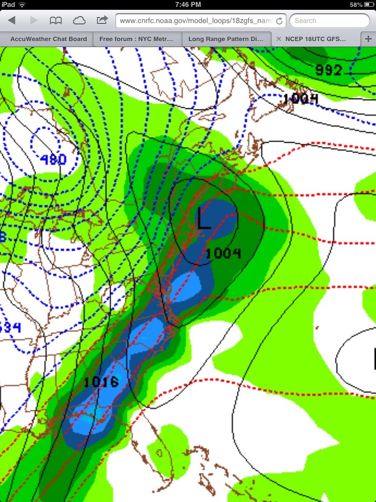
Here is the storm around the 17th. I have a feeling it will be too warm for us, but plenty of time to still watch this. This is the 18z GFS
Frank_Wx- Godzilla Seeker
- Posts : 21305
Reputation : 328
Join date : 2013-01-05
Age : 31
Location : Jersey City, NJ -
Re: January 2013 Long Range Thread
![]() by aiannone Mon Jan 07, 2013 9:00 pm
by aiannone Mon Jan 07, 2013 9:00 pm

aiannone- Senior Enthusiast - Mod
- Posts : 4813
Reputation : 92
Join date : 2013-01-07
Location : Saint James, LI (Northwest Suffolk Co.)
Re: January 2013 Long Range Thread
![]() by Frank_Wx Mon Jan 07, 2013 9:03 pm
by Frank_Wx Mon Jan 07, 2013 9:03 pm
Frank_Wx- Godzilla Seeker
- Posts : 21305
Reputation : 328
Join date : 2013-01-05
Age : 31
Location : Jersey City, NJ -
Re: January 2013 Long Range Thread
![]() by Frank_Wx Mon Jan 07, 2013 11:57 pm
by Frank_Wx Mon Jan 07, 2013 11:57 pm

And the 17th storm is there again on the 00z GFS...
Frank_Wx- Godzilla Seeker
- Posts : 21305
Reputation : 328
Join date : 2013-01-05
Age : 31
Location : Jersey City, NJ -
Re: January 2013 Long Range Thread
![]() by Nystripe96 Tue Jan 08, 2013 12:13 am
by Nystripe96 Tue Jan 08, 2013 12:13 am
Nystripe96- Posts : 5
Reputation : 0
Join date : 2013-01-08
Re: January 2013 Long Range Thread
![]() by Frank_Wx Tue Jan 08, 2013 12:16 am
by Frank_Wx Tue Jan 08, 2013 12:16 am
Between now and the 15th is torture. Once we gets near the 16th, pattern should be much more favorable, regardless of if the 17th storm pans out.
Frank_Wx- Godzilla Seeker
- Posts : 21305
Reputation : 328
Join date : 2013-01-05
Age : 31
Location : Jersey City, NJ -
Re: January 2013 Long Range Thread
![]() by Nystripe96 Tue Jan 08, 2013 12:29 am
by Nystripe96 Tue Jan 08, 2013 12:29 am
Nystripe96- Posts : 5
Reputation : 0
Join date : 2013-01-08
Re: January 2013 Long Range Thread
![]() by Frank_Wx Tue Jan 08, 2013 12:34 am
by Frank_Wx Tue Jan 08, 2013 12:34 am
Nystripe96 wrote:Everyday this winter has been torture lol. It seems everybody west of I95 has had at least some semblance of a winter
Yea, really. But honestly, I was expecting this to happen. Our only hope is the NAO gets negative or else we will remain on the snow/rain line.
By the way...00z GEFS look good.
Frank_Wx- Godzilla Seeker
- Posts : 21305
Reputation : 328
Join date : 2013-01-05
Age : 31
Location : Jersey City, NJ -
Re: January 2013 Long Range Thread
![]() by Nystripe96 Tue Jan 08, 2013 12:46 am
by Nystripe96 Tue Jan 08, 2013 12:46 am
Nystripe96- Posts : 5
Reputation : 0
Join date : 2013-01-08
Re: January 2013 Long Range Thread
![]() by Frank_Wx Tue Jan 08, 2013 9:00 am
by Frank_Wx Tue Jan 08, 2013 9:00 am
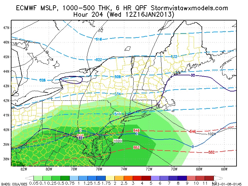
Euro now shows frozen precip getting into the area between the 16th-17th...
Frank_Wx- Godzilla Seeker
- Posts : 21305
Reputation : 328
Join date : 2013-01-05
Age : 31
Location : Jersey City, NJ -
Re: January 2013 Long Range Thread
![]() by Frank_Wx Tue Jan 08, 2013 11:43 am
by Frank_Wx Tue Jan 08, 2013 11:43 am
Frank_Wx- Godzilla Seeker
- Posts : 21305
Reputation : 328
Join date : 2013-01-05
Age : 31
Location : Jersey City, NJ -
Nystripe96- Posts : 5
Reputation : 0
Join date : 2013-01-08
Re: January 2013 Long Range Thread
![]() by Frank_Wx Tue Jan 08, 2013 1:05 pm
by Frank_Wx Tue Jan 08, 2013 1:05 pm
Frank_Wx- Godzilla Seeker
- Posts : 21305
Reputation : 328
Join date : 2013-01-05
Age : 31
Location : Jersey City, NJ -
Pattern Change
![]() by sroc4 Tue Jan 08, 2013 1:58 pm
by sroc4 Tue Jan 08, 2013 1:58 pm

sroc4- Admin
- Posts : 8331
Reputation : 301
Join date : 2013-01-07
Location : Wading River, LI
Re: January 2013 Long Range Thread
![]() by Nystripe96 Tue Jan 08, 2013 3:07 pm
by Nystripe96 Tue Jan 08, 2013 3:07 pm
Nystripe96- Posts : 5
Reputation : 0
Join date : 2013-01-08
Re: January 2013 Long Range Thread
![]() by sroc4 Tue Jan 08, 2013 3:27 pm
by sroc4 Tue Jan 08, 2013 3:27 pm
Nystripe96 wrote: I'm hoping the SE ridge just falls apart allowing the intrusion of cold which the 12z is showing. I do have my doubts, but hopefully the vast expanse of the continental snowpack will allow for a further transition eastward
Hey Stripe the NAO has been pretty consistently showing up in the LR as going neg and staying there. I think this will allow the cold air to start building on the SE ridge. The SE ridge will eventually be pushed back. The GFS unfort is really the only model as of now showing a slight Pos PNA. The rest are still showing neg but we shall see.
0z comparisons
http://raleighwx.americanwx.com/models/00zPNAcomparison.html
12z Comparisons
http://raleighwx.americanwx.com/models/12zPNAcomparison.html
But as Frank pointed out in his Blog the EPO looks ripe to be neg which will hopefully still allow the ridge to take shape in the Eastern Pacific. I just hope the ridge is close enough to the west coast so enough cold air can be forced into the CONUS and make it far enough east to help beat back the SE ridge with blocking in place.
sroc4- Admin
- Posts : 8331
Reputation : 301
Join date : 2013-01-07
Location : Wading River, LI
Re: January 2013 Long Range Thread
![]() by aiannone Tue Jan 08, 2013 3:53 pm
by aiannone Tue Jan 08, 2013 3:53 pm
THE SECOND PATTERN CHANGE WILL BEGIN TO SHOW ITS CARDS BY THE MIDDLE
OF THE MONTH. A MAJOR SUDDEN STRATOSPHERIC WARMING EVENT IS UNDERWAY
AND NEARING COMPLETION. SUDDEN STRATOSPHERIC WARMING EVENTS ARE
FAVORED TO OCCUR DURING AN EASTERLY PHASE OF THE QUASI-BIENNIAL
OSCILLATION /QBO/…WHICH IS THE PHASE THE STRATOSPHERE IS IN THIS
WINTER. THE SUDDEN STRATOSPHERIC WARMING CAUSES A DRAMATIC
WEAKENING…AND SOMETIMES ENTIRE BREAKDOWN OF THE STRATOSPHERIC
POLAR VORTEX…AND A GREAT WEAKENING OR EVEN REVERSAL OF THE
STRATOSPHERIC POLAR NIGHT JET. THE GFS FORECASTS THIS TO OCCUR OVER
THE NEXT WEEK AT THE 2MB LEVEL.
THE RESULT OF ALL OF THIS IS THE GENERATION OF STRONG HIGH LATITUDE
BLOCKING AS THE DRAMATIC CHANGES IN THE STRATOSPHERE FEED DOWN INTO
THE TROPOSPHERE. HIGH LATITUDE BLOCKING FORCES THE COLDEST AIR SOUTH
OUT OF THE HIGH ARCTIC AND TOWARDS THE MID LATITUDES…AND ALSO
FAVORS LASTING STRONGLY NEGATIVE EPISODES OF ARCTIC OSCILLATION /AO/
AND NORTH ATLANTIC OSCILLATION /NAO/. THIS TYPICALLY BEGINS TO TAKE
PLACE 10-15 DAYS AFTER THE SUDDEN STRATOSPHERIC WARMING EVENT. HOW
LONG IT LASTS CAN VARY…BUT TYPICALLY THE COLD PATTERN LASTS FOR AT
LEAST A FEW WEEKS…AND OCCASIONALLY CAN PERSIST THROUGH THE REST OF
WINTER.
AS ALL OF THIS IS OCCURRING…THE MJO IS FORECAST BY THE GEFS
ENSEMBLES TO WEAKEN AND FADE AWAY IN ABOUT 10 DAYS. THE PACIFIC
NORTH AMERICAN PATTERN /PNA/ IS FORECAST TO REMAIN NEGATIVE OVER THE
NEXT 10 DAYS…WHICH WILL DIRECT THE FIRST BATCHES OF COLD INTO THE
WESTERN AND EVENTUALLY CENTRAL UNITED STATES. GEFS ENSEMBLE MEMBERS
SUPPORT A TREND TOWARDS A NEUTRAL OR POSITIVE PNA BY THE MIDDLE OF
THE MONTH…WHICH SHOULD ALLOW THE GROWING COLD TO SPREAD EASTWARD.
WHAT ALL OF THIS TECHNICAL JARGON MEANS IS THAT THERE IS MODERATE TO
HIGH CONFIDENCE IN A PATTERN CHANGE TOWARDS MUCH COLDER WEATHER FOR
THE CENTRAL AND EASTERN UNITED STATES STARTING AROUND THE MIDDLE OF
JANUARY…WITH COLD LIKELY PEAKING IN LATE JANUARY INTO EARLY
FEBRUARY. THERE IS THE POTENTIAL FOR THE COLDEST AIR WE HAVE SEEN IN
AT LEAST SEVERAL YEARS DURING THIS PERIOD. WHAT SNOW POTENTIAL THIS
WILL BRING IS MUCH MORE UNCERTAIN DUE TO UNKNOWN DETAILS WITH
SYNOPTIC STORM TRACK AND LAKE EFFECT POTENTIAL.
aiannone- Senior Enthusiast - Mod
- Posts : 4813
Reputation : 92
Join date : 2013-01-07
Location : Saint James, LI (Northwest Suffolk Co.)
Re: January 2013 Long Range Thread
![]() by NjWeatherGuy Tue Jan 08, 2013 7:30 pm
by NjWeatherGuy Tue Jan 08, 2013 7:30 pm
From what i've seen before the pattern change arrives a very slow moving cold front will move over the region. To me it looked pretty strong so I checked the GFS and today's 18z run at hour 192 shows elevated CAPE, lifting and showalter indeces over our area. Nothing too extreme but I think we cant rule out some rumbles of thunder or lightning as this passes through. Of course, it's too far away at this time to know what will happen exactly.

NjWeatherGuy- Advanced Forecaster

- Posts : 4100
Reputation : 28
Join date : 2013-01-06
Location : Belle Mead, NJ
Page 1 of 5 • 1, 2, 3, 4, 5 ![]()
|
|
|