
 Search
March 2nd-4th Potential Snowstorm
Page 18 of 43 •  1 ... 10 ... 17, 18, 19 ... 30 ... 43
 ![]()
Re: March 2nd-4th Potential Snowstorm
![]() by jmanley32 Thu Feb 27, 2014 2:35 pm
by jmanley32 Thu Feb 27, 2014 2:35 pm
jmanley32- Senior Enthusiast

- Posts : 20516
Join date : 2013-12-12
Re: March 2nd-4th Potential Snowstorm
![]() by amugs Thu Feb 27, 2014 2:36 pm
by amugs Thu Feb 27, 2014 2:36 pm
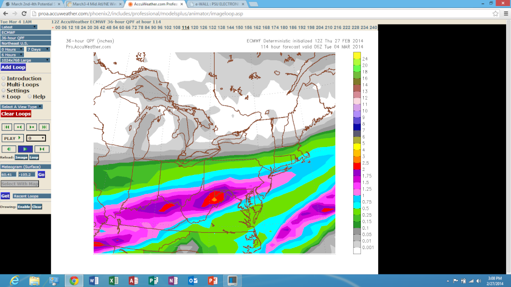
Mets2695 wrote:Accuweather:
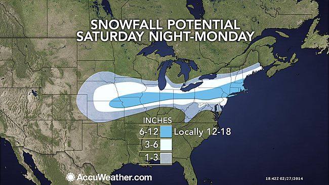
The best forecast they have been out all winter long!! HAHAHAHA!!
amugs- Advanced Forecaster - Mod

- Posts : 15093
Join date : 2013-01-07
Re: March 2nd-4th Potential Snowstorm
![]() by jmanley32 Thu Feb 27, 2014 2:36 pm
by jmanley32 Thu Feb 27, 2014 2:36 pm

jmanley32- Senior Enthusiast
- Posts : 20516
Reputation : 108
Join date : 2013-12-12
Age : 42
Location : Yonkers, NY
Re: March 2nd-4th Potential Snowstorm
![]() by SNOW MAN Thu Feb 27, 2014 2:40 pm
by SNOW MAN Thu Feb 27, 2014 2:40 pm
amugs wrote:Mets2695 wrote:Accuweather:
The best forecast they have been out all winter long!! HAHAHAHA!!
A snow weenies dream. I can only hope.

SNOW MAN- Senior Enthusiast
- Posts : 1361
Reputation : 25
Join date : 2013-01-13
Age : 64
Location : Marshalls Creek Pa.
Re: March 2nd-4th Potential Snowstorm
![]() by docstox12 Thu Feb 27, 2014 2:48 pm
by docstox12 Thu Feb 27, 2014 2:48 pm
jmanley32 wrote:thats a pretty big spread so 6-18 inches lol. Thats accu for ya!
Yeah, Inaccuweather at it's best.
I had an old GF who called me a "commitophobic" but Accuweather's refusal to pinpoint these snow amounts beats me out easily.

docstox12- Wx Statistician Guru

- Posts : 8504
Reputation : 222
Join date : 2013-01-07
Age : 73
Location : Monroe NY
Re: March 2nd-4th Potential Snowstorm
![]() by docstox12 Thu Feb 27, 2014 2:51 pm
by docstox12 Thu Feb 27, 2014 2:51 pm
Mets2695 wrote:Accuweather:
They are not buying that euro solution that has the heavy snow way further south.They have much lesser amounts south.
Stay tuned!!!!!
docstox12- Wx Statistician Guru
- Posts : 8504
Reputation : 222
Join date : 2013-01-07
Age : 73
Location : Monroe NY
Re: March 2nd-4th Potential Snowstorm
![]() by sroc4 Thu Feb 27, 2014 3:06 pm
by sroc4 Thu Feb 27, 2014 3:06 pm
 " />
" /> " />
" /> " />
" />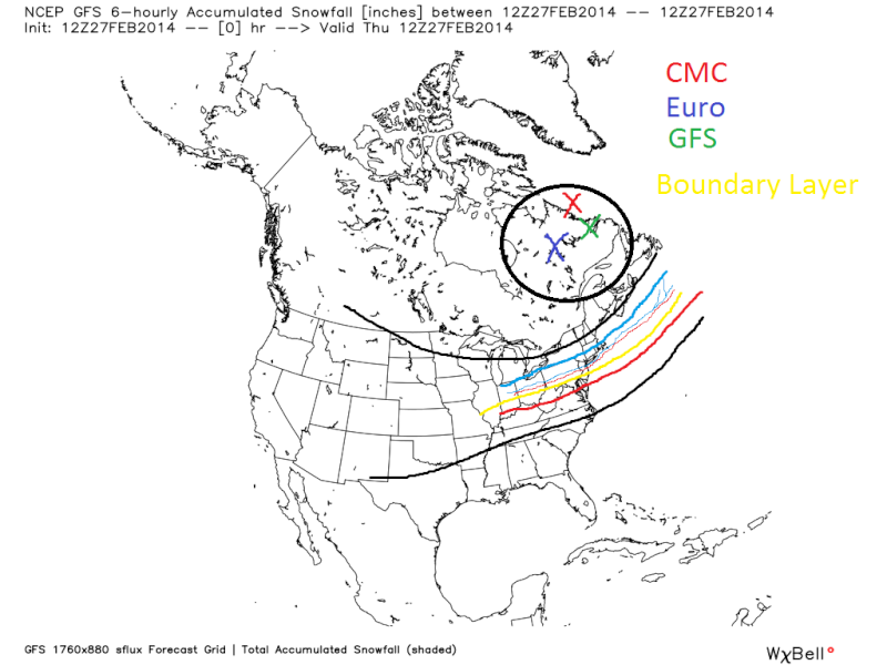 " />
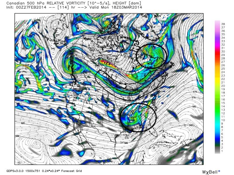
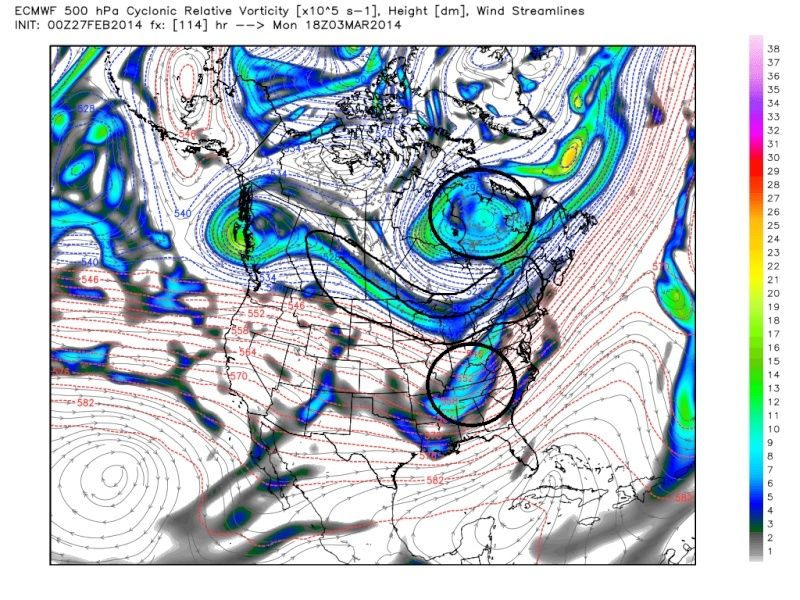
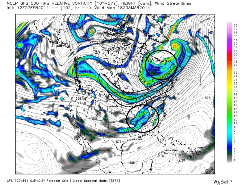
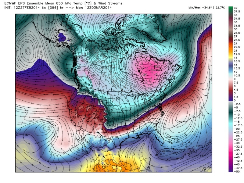
" />To me the GFS took a few big steps from what it was showing a few days ago. This next image below was the image from the GFS a few days ago. Look at the weakness in the northern stream. That allowed the SE Ridge to build in to strong and send the R/S line N into the HV. If you compare it to the image from todays 12z GFS above obviously that has changed. The second feature that has changed is the PV. The other day the GFS had it separated into 3 distinct centers of circulation. To some degree the CMC today tried to do something similar but I believe this is wrong. And the third one is now all three models have the southern energy more consolidated ejecting pieces of it out along the boundary layer. Look at the image below (12z 2/25) compared to the ones above (today).
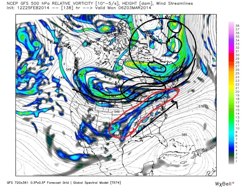 " />
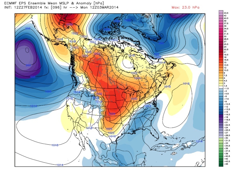
" />All models have now been consistently showing this extended region of vorticity embedded within the northern stream extending from western Canada to Eastern Canada where the PV is. The strength of the northern branch is helping to keep the SE ridge from building northward too much. As a result HP is present north of the great lakes and into Maine which will enforce the cold air. Another consistency on all three models is that this HP to the north is strengthening instead of weakening from Sat into Monday which will help to enforce the cold air further.
 " />
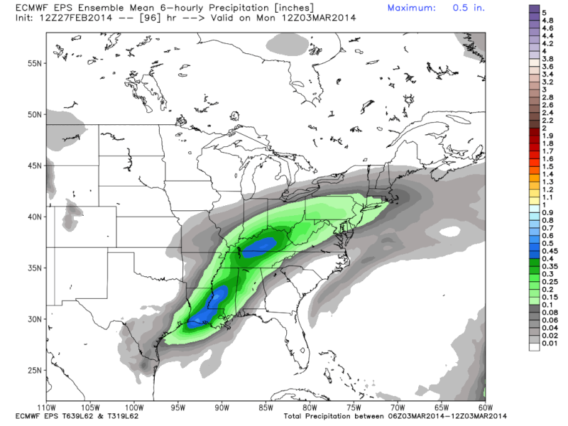
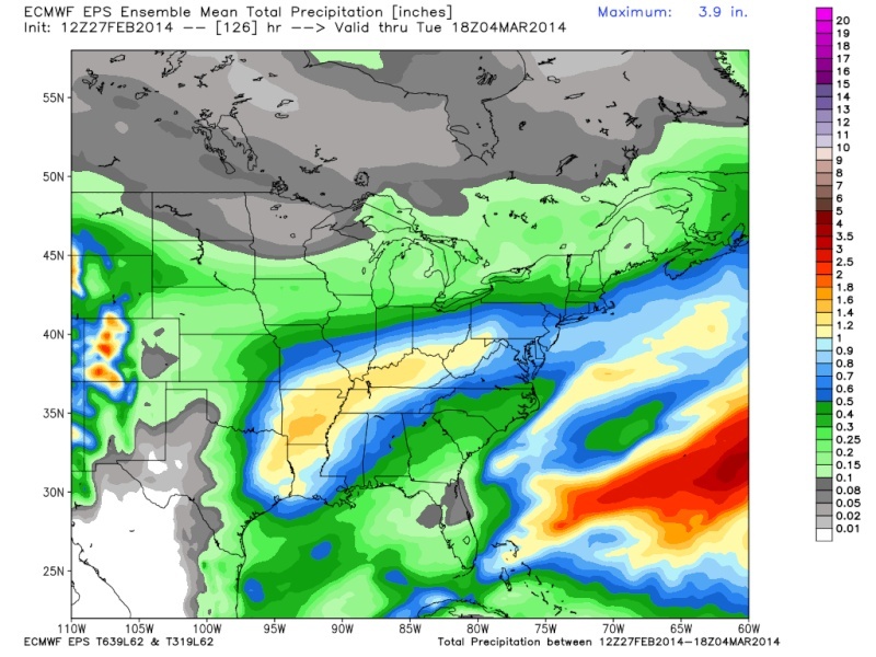
" />To me all this creates a set up where the 0* 850 Line will set up shop somewhere just south of LI possibly cutting through the south shore and south fork extending west through central NJ give or take about 15-25miles. Mixing may occur for places like LI but I think it will be short lived and remain fairly insignificant when all is said and done given the duration of this event.
So I believe that there is enough consistency that a solid swath of 6-12", possibly more in some locations, extending from the HV southward through central NJ and LI will happen. The details will be if there is a shift N or S by about 25-30 miles and whether the QPF amts fluctuate much. to me 4-8" in that zone is almost a lock and as much as 12-18" is possible.
_________________
"In weather and in life, there's no winning and losing; there's only winning and learning."
WINTER 2012/2013 TOTALS 43.65"WINTER 2017/2018 TOTALS 62.85" WINTER 2022/2023 TOTALS 4.9"
WINTER 2013/2014 TOTALS 64.85"WINTER 2018/2019 TOTALS 14.25" WINTER 2023/2024 TOTALS 13.1"
WINTER 2014/2015 TOTALS 71.20"WINTER 2019/2020 TOTALS 6.35"
WINTER 2015/2016 TOTALS 35.00"WINTER 2020/2021 TOTALS 37.75"
WINTER 2016/2017 TOTALS 42.25"WINTER 2021/2022 TOTALS 31.65"

sroc4- Admin

- Posts : 8331
Reputation : 301
Join date : 2013-01-07
Location : Wading River, LI
Re: March 2nd-4th Potential Snowstorm
![]() by NjWeatherGuy Thu Feb 27, 2014 3:10 pm
by NjWeatherGuy Thu Feb 27, 2014 3:10 pm

NjWeatherGuy- Advanced Forecaster

- Posts : 4100
Reputation : 28
Join date : 2013-01-06
Location : Belle Mead, NJ
Re: March 2nd-4th Potential Snowstorm
![]() by aiannone Thu Feb 27, 2014 3:15 pm
by aiannone Thu Feb 27, 2014 3:15 pm
_________________
-Alex Iannone-

aiannone- Senior Enthusiast - Mod
- Posts : 4813
Reputation : 92
Join date : 2013-01-07
Location : Saint James, LI (Northwest Suffolk Co.)
Re: March 2nd-4th Potential Snowstorm
![]() by NjWeatherGuy Thu Feb 27, 2014 3:17 pm
by NjWeatherGuy Thu Feb 27, 2014 3:17 pm
NjWeatherGuy- Advanced Forecaster
- Posts : 4100
Reputation : 28
Join date : 2013-01-06
Location : Belle Mead, NJ
Re: March 2nd-4th Potential Snowstorm
![]() by Quietace Thu Feb 27, 2014 3:19 pm
by Quietace Thu Feb 27, 2014 3:19 pm
Only to 54 on Wxbell also. I wonder where people get them so quick.NjWeatherGuy wrote:Evidently the EURO Ensembles are colder and a tad north of the 12z OP run, a very good thing if it's true. I cannot verify ATM.

Quietace- Meteorologist - Mod

- Posts : 3687
Reputation : 33
Join date : 2013-01-07
Age : 27
Location : Point Pleasant, NJ
Re: March 2nd-4th Potential Snowstorm
![]() by NjWeatherGuy Thu Feb 27, 2014 3:20 pm
by NjWeatherGuy Thu Feb 27, 2014 3:20 pm
Quietace wrote:Only to 54 on Wxbell also. I wonder where people get them so quick.NjWeatherGuy wrote:Evidently the EURO Ensembles are colder and a tad north of the 12z OP run, a very good thing if it's true. I cannot verify ATM.
No idea, on pro it doesn't come in until 530, lol, it's a joke. Some people probably have very expensive subscriptions (not that pro is cheap), please post if u get it Ace.
NjWeatherGuy- Advanced Forecaster
- Posts : 4100
Reputation : 28
Join date : 2013-01-06
Location : Belle Mead, NJ
Re: March 2nd-4th Potential Snowstorm
![]() by skinsfan1177 Thu Feb 27, 2014 3:20 pm
by skinsfan1177 Thu Feb 27, 2014 3:20 pm

skinsfan1177- Senior Enthusiast
- Posts : 4485
Reputation : 35
Join date : 2013-01-07
Age : 46
Location : Point Pleasant Boro
Re: March 2nd-4th Potential Snowstorm
![]() by NjWeatherGuy Thu Feb 27, 2014 3:23 pm
by NjWeatherGuy Thu Feb 27, 2014 3:23 pm
skinsfan1177 wrote:I think the heavier snow will be farther south than the accuweather map IMO
I agree, right along and within 30 miles of 95 in either direction looks like a good spot to be in ATM. Right now I have highest confidence in all snow if you draw a line connecting the two indentations of NJ and north of there I am fairly confident in all snow. 20 miles to the south has a good chance at all snow, more uncertain further south.
NjWeatherGuy- Advanced Forecaster
- Posts : 4100
Reputation : 28
Join date : 2013-01-06
Location : Belle Mead, NJ
Re: March 2nd-4th Potential Snowstorm
![]() by jmanley32 Thu Feb 27, 2014 3:26 pm
by jmanley32 Thu Feb 27, 2014 3:26 pm
jmanley32- Senior Enthusiast
- Posts : 20516
Reputation : 108
Join date : 2013-12-12
Age : 42
Location : Yonkers, NY
Re: March 2nd-4th Potential Snowstorm
![]() by jmanley32 Thu Feb 27, 2014 3:27 pm
by jmanley32 Thu Feb 27, 2014 3:27 pm
jmanley32- Senior Enthusiast
- Posts : 20516
Reputation : 108
Join date : 2013-12-12
Age : 42
Location : Yonkers, NY
Re: March 2nd-4th Potential Snowstorm
![]() by jmanley32 Thu Feb 27, 2014 3:28 pm
by jmanley32 Thu Feb 27, 2014 3:28 pm
jmanley32- Senior Enthusiast
- Posts : 20516
Reputation : 108
Join date : 2013-12-12
Age : 42
Location : Yonkers, NY
Re: March 2nd-4th Potential Snowstorm
![]() by Quietace Thu Feb 27, 2014 3:30 pm
by Quietace Thu Feb 27, 2014 3:30 pm

Last edited by Quietace on Thu Feb 27, 2014 3:31 pm; edited 1 time in total
Quietace- Meteorologist - Mod
- Posts : 3687
Reputation : 33
Join date : 2013-01-07
Age : 27
Location : Point Pleasant, NJ
Re: March 2nd-4th Potential Snowstorm
![]() by jmanley32 Thu Feb 27, 2014 3:30 pm
by jmanley32 Thu Feb 27, 2014 3:30 pm
jmanley32- Senior Enthusiast
- Posts : 20516
Reputation : 108
Join date : 2013-12-12
Age : 42
Location : Yonkers, NY
Re: March 2nd-4th Potential Snowstorm
![]() by NjWeatherGuy Thu Feb 27, 2014 3:31 pm
by NjWeatherGuy Thu Feb 27, 2014 3:31 pm
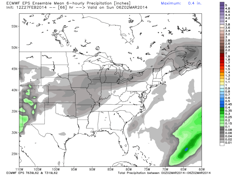
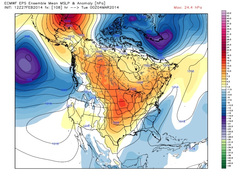
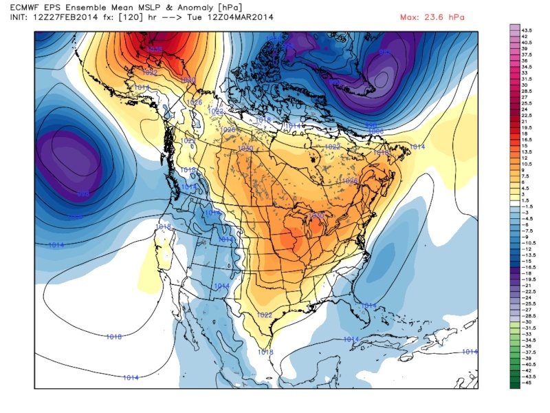
Quietace wrote:A Early Euro ensemble pic.
Any 850s and precip combination maps?
NjWeatherGuy- Advanced Forecaster
- Posts : 4100
Reputation : 28
Join date : 2013-01-06
Location : Belle Mead, NJ
Quietace- Meteorologist - Mod
- Posts : 3687
Reputation : 33
Join date : 2013-01-07
Age : 27
Location : Point Pleasant, NJ
Re: March 2nd-4th Potential Snowstorm
![]() by Quietace Thu Feb 27, 2014 3:37 pm
by Quietace Thu Feb 27, 2014 3:37 pm
Hr 96 was the warmest 850s got.
Quietace- Meteorologist - Mod
- Posts : 3687
Reputation : 33
Join date : 2013-01-07
Age : 27
Location : Point Pleasant, NJ
Re: March 2nd-4th Potential Snowstorm
![]() by sroc4 Thu Feb 27, 2014 3:39 pm
by sroc4 Thu Feb 27, 2014 3:39 pm
_________________
"In weather and in life, there's no winning and losing; there's only winning and learning."
WINTER 2012/2013 TOTALS 43.65"WINTER 2017/2018 TOTALS 62.85" WINTER 2022/2023 TOTALS 4.9"
WINTER 2013/2014 TOTALS 64.85"WINTER 2018/2019 TOTALS 14.25" WINTER 2023/2024 TOTALS 13.1"
WINTER 2014/2015 TOTALS 71.20"WINTER 2019/2020 TOTALS 6.35"
WINTER 2015/2016 TOTALS 35.00"WINTER 2020/2021 TOTALS 37.75"
WINTER 2016/2017 TOTALS 42.25"WINTER 2021/2022 TOTALS 31.65"
sroc4- Admin
- Posts : 8331
Reputation : 301
Join date : 2013-01-07
Location : Wading River, LI
NjWeatherGuy- Advanced Forecaster
- Posts : 4100
Reputation : 28
Join date : 2013-01-06
Location : Belle Mead, NJ
Re: March 2nd-4th Potential Snowstorm
![]() by docstox12 Thu Feb 27, 2014 3:39 pm
by docstox12 Thu Feb 27, 2014 3:39 pm
jmanley32 wrote:Just watched Raynos video, he at 10am was still mentioning the R word for NYC and south? I don't see this happening with all the maps here and the talk. I usually like him but didn't like that piece!
Watched Myers video and he feels at this point everyone north of Route 80 stays all snow with mixing gradually more as you head for the PA Turnpike and sleet and rain south of that.He said a slight southern track would take the 6 to 12 further south of Route 80 but a slight northward jog would drop accumulations to 4 to 6 North of 80.
docstox12- Wx Statistician Guru
- Posts : 8504
Reputation : 222
Join date : 2013-01-07
Age : 73
Location : Monroe NY
Re: March 2nd-4th Potential Snowstorm
![]() by Quietace Thu Feb 27, 2014 3:40 pm
by Quietace Thu Feb 27, 2014 3:40 pm
Its right on.sroc4 wrote:Man I used to do a write up and get at least some feedback. Anyone have any thoughts, criticisms, anything??
Quietace- Meteorologist - Mod
- Posts : 3687
Reputation : 33
Join date : 2013-01-07
Age : 27
Location : Point Pleasant, NJ
Quietace- Meteorologist - Mod
- Posts : 3687
Reputation : 33
Join date : 2013-01-07
Age : 27
Location : Point Pleasant, NJ
Page 18 of 43 • 1 ... 10 ... 17, 18, 19 ... 30 ... 43 ![]()
|
|
|