
 Search
Official Long Range Thread 4.0
Page 27 of 42 •  1 ... 15 ... 26, 27, 28 ... 34 ... 42
 ![]()
Re: Official Long Range Thread 4.0
![]() by Snow88 Tue Dec 02, 2014 10:55 am
by Snow88 Tue Dec 02, 2014 10:55 am


Euro is the only one that sends the MJO into the COD

Snow88- Senior Enthusiast

- Posts : 2193
Join date : 2013-01-09
Re: Official Long Range Thread 4.0
![]() by amugs Tue Dec 02, 2014 11:02 am
by amugs Tue Dec 02, 2014 11:02 am
Frank_Wx wrote:Typhoon is expected to slow down and reach super status. Big question is whether or not it recurves

The link I posted last night has it like you said becoming a pretty intense typhoon which is pretty rare at this stage of the season from what I have read and it shows it slowly taking a turn to the NE once it slides by the Philippines but we shall see.
Last edited by amugs on Tue Dec 02, 2014 12:36 pm; edited 1 time in total
amugs- Advanced Forecaster - Mod

- Posts : 15093
Join date : 2013-01-07
Re: Official Long Range Thread 4.0
![]() by amugs Tue Dec 02, 2014 12:30 pm
by amugs Tue Dec 02, 2014 12:30 pm

NAO

PNA

They (charts) concur with the fact that the US is flooded with PAC air and keeps us about +2-3 degrees (I hope) ABOVE NORMAL for the first half of the month and then we start to see some winter effects after that as per this charts - we'll see.
_________________
Mugs
AKA:King: Snow Weenie
Self Proclaimed
WINTER 2014-15 : 55.12" +.02 for 6 coatings (avg. 35")
WINTER 2015-16 Total - 29.8" (Avg 35")
WINTER 2016-17 : 39.5" so far

amugs- Advanced Forecaster - Mod
- Posts : 15093
Reputation : 213
Join date : 2013-01-07
Age : 54
Location : Hillsdale,NJ
Re: Official Long Range Thread 4.0
![]() by Snow88 Tue Dec 02, 2014 12:30 pm
by Snow88 Tue Dec 02, 2014 12:30 pm

Snow88- Senior Enthusiast
- Posts : 2193
Reputation : 4
Join date : 2013-01-09
Age : 35
Location : Brooklyn, NY
Re: Official Long Range Thread 4.0
![]() by amugs Tue Dec 02, 2014 12:37 pm
by amugs Tue Dec 02, 2014 12:37 pm
Snow88 wrote:People need to be patient. Most of the outlooks that I have seen had a warm start to December with a gradual change to colder weather as the month went on. Winter should commence by late December according to most of the outlooks.
Tony as depicted in the charts i just posted.
_________________
Mugs
AKA:King: Snow Weenie
Self Proclaimed
WINTER 2014-15 : 55.12" +.02 for 6 coatings (avg. 35")
WINTER 2015-16 Total - 29.8" (Avg 35")
WINTER 2016-17 : 39.5" so far
amugs- Advanced Forecaster - Mod
- Posts : 15093
Reputation : 213
Join date : 2013-01-07
Age : 54
Location : Hillsdale,NJ
Re: Official Long Range Thread 4.0
![]() by Snow88 Tue Dec 02, 2014 12:48 pm
by Snow88 Tue Dec 02, 2014 12:48 pm
amugs wrote:Snow88 wrote:People need to be patient. Most of the outlooks that I have seen had a warm start to December with a gradual change to colder weather as the month went on. Winter should commence by late December according to most of the outlooks.
Tony as depicted in the charts i just posted.
Models usually have a tough time with pattern changes. I wonder if they are going through it now since all of the models don't show anything good for the long range. Looks like a slow and nice transition should happen by mid month based off those charts.
Snow88- Senior Enthusiast
- Posts : 2193
Reputation : 4
Join date : 2013-01-09
Age : 35
Location : Brooklyn, NY
Re: Official Long Range Thread 4.0
![]() by jmanley32 Tue Dec 02, 2014 1:20 pm
by jmanley32 Tue Dec 02, 2014 1:20 pm

jmanley32- Senior Enthusiast
- Posts : 20517
Reputation : 108
Join date : 2013-12-12
Age : 42
Location : Yonkers, NY
Re: Official Long Range Thread 4.0
![]() by HectorO Tue Dec 02, 2014 3:52 pm
by HectorO Tue Dec 02, 2014 3:52 pm

HectorO- Pro Enthusiast

- Posts : 959
Reputation : 27
Join date : 2013-01-11
Re: Official Long Range Thread 4.0
![]() by aiannone Tue Dec 02, 2014 4:10 pm
by aiannone Tue Dec 02, 2014 4:10 pm
Friday Partly sunny, with a high near 23. Calm wind becoming south 5 to 7 mph in the morning.
Friday Night A 40 percent chance of snow. Mostly cloudy, with a low around 23. South wind around 6 mph.
Saturday A chance of rain and snow. Cloudy, with a high near 37. Calm wind. Chance of precipitation is 40%.
Saturday Night Mostly cloudy, with a low around 24. Light north wind.
Sunday Mostly sunny, with a high near 34. Calm wind.
Sunday Night A 30 percent chance of snow. Mostly cloudy, with a low around 26. Calm wind.
Monday Snow likely. Mostly cloudy, with a high near 32. Light southeast wind. Chance of precipitation is 70%.
_________________
-Alex Iannone-

aiannone- Senior Enthusiast - Mod
- Posts : 4814
Reputation : 92
Join date : 2013-01-07
Location : Saint James, LI (Northwest Suffolk Co.)
Re: Official Long Range Thread 4.0
![]() by HectorO Tue Dec 02, 2014 4:14 pm
by HectorO Tue Dec 02, 2014 4:14 pm
aiannone wrote:What boring pattern are you guys talking about lol?! JKJKJK. I guess Vermont never fails to get snow, regardless of the pattern. Look at my forecast lol. NWS Burlington seems really intrigued for Monday with a 70% chance of snow already!
Friday Partly sunny, with a high near 23. Calm wind becoming south 5 to 7 mph in the morning.
Friday Night A 40 percent chance of snow. Mostly cloudy, with a low around 23. South wind around 6 mph.
Saturday A chance of rain and snow. Cloudy, with a high near 37. Calm wind. Chance of precipitation is 40%.
Saturday Night Mostly cloudy, with a low around 24. Light north wind.
Sunday Mostly sunny, with a high near 34. Calm wind.
Sunday Night A 30 percent chance of snow. Mostly cloudy, with a low around 26. Calm wind.
Monday Snow likely. Mostly cloudy, with a high near 32. Light southeast wind. Chance of precipitation is 70%.
My fiend lives in Vermont. Forgot what town but she got like 1.5/2feet of snow thanksgiving. Too many things factor weather in the mid Atlantic.
HectorO- Pro Enthusiast
- Posts : 959
Reputation : 27
Join date : 2013-01-11
Re: Official Long Range Thread 4.0
![]() by aiannone Tue Dec 02, 2014 4:18 pm
by aiannone Tue Dec 02, 2014 4:18 pm
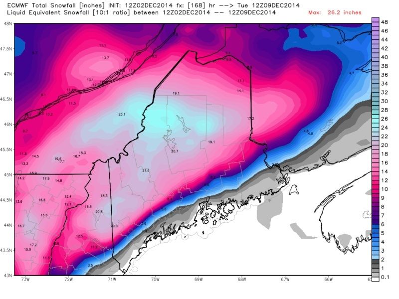
EURO
Last edited by aiannone on Tue Dec 02, 2014 4:36 pm; edited 1 time in total
_________________
-Alex Iannone-
aiannone- Senior Enthusiast - Mod
- Posts : 4814
Reputation : 92
Join date : 2013-01-07
Location : Saint James, LI (Northwest Suffolk Co.)
Re: Official Long Range Thread 4.0
![]() by jmanley32 Tue Dec 02, 2014 4:34 pm
by jmanley32 Tue Dec 02, 2014 4:34 pm
jmanley32- Senior Enthusiast
- Posts : 20517
Reputation : 108
Join date : 2013-12-12
Age : 42
Location : Yonkers, NY
Re: Official Long Range Thread 4.0
![]() by aiannone Tue Dec 02, 2014 4:37 pm
by aiannone Tue Dec 02, 2014 4:37 pm
jmanley32 wrote:Ahhh grrr go away Alex lol, of course your going to see snow before us! That looks nice. Those maps can be overdone but looks like u will get snow. Our days will come and when we get our coastals and u get nada , trust me Ima gonna brag to you lol. All in good fun my friend.
Haha hopefully i will get the best of both worlds when I'm home for a month in Late December into January
_________________
-Alex Iannone-
aiannone- Senior Enthusiast - Mod
- Posts : 4814
Reputation : 92
Join date : 2013-01-07
Location : Saint James, LI (Northwest Suffolk Co.)
Re: Official Long Range Thread 4.0
![]() by algae888 Tue Dec 02, 2014 5:15 pm
by algae888 Tue Dec 02, 2014 5:15 pm

algae888- Advanced Forecaster

- Posts : 5311
Reputation : 46
Join date : 2013-02-05
Age : 61
Location : mt. vernon, new york
Re: Official Long Range Thread 4.0
![]() by sroc4 Tue Dec 02, 2014 5:24 pm
by sroc4 Tue Dec 02, 2014 5:24 pm
Frank_Wx wrote:Typhoon is expected to slow down and reach super status. Big question is whether or not it recurves
Mark my words...IF this typhoon recurves you watch how different the LR model out put will look at soon as the models catch on to it. Its going to be 180. When Nuri was forecasted to recurve in early Nov. not one model accurately showed what actually ended up happening in the LR for the month of Nov until Nuri or its remnants were well up into the N Pac. IMHO this system is the trigger. And as soon as it figures out what it wants to do we will see how the models flip. Plus the Stratospheric warming actually taking place right now looks to good. Remember..............wait for it.........
https://www.youtube.com/watch?v=N_vssdys8lk
_________________
"In weather and in life, there's no winning and losing; there's only winning and learning."
WINTER 2012/2013 TOTALS 43.65"WINTER 2017/2018 TOTALS 62.85" WINTER 2022/2023 TOTALS 4.9"
WINTER 2013/2014 TOTALS 64.85"WINTER 2018/2019 TOTALS 14.25" WINTER 2023/2024 TOTALS 13.1"
WINTER 2014/2015 TOTALS 71.20"WINTER 2019/2020 TOTALS 6.35"
WINTER 2015/2016 TOTALS 35.00"WINTER 2020/2021 TOTALS 37.75"
WINTER 2016/2017 TOTALS 42.25"WINTER 2021/2022 TOTALS 31.65"

sroc4- Admin

- Posts : 8331
Reputation : 301
Join date : 2013-01-07
Location : Wading River, LI
Re: Official Long Range Thread 4.0
![]() by HectorO Tue Dec 02, 2014 6:04 pm
by HectorO Tue Dec 02, 2014 6:04 pm
True. What happened next was I got snow on Christmas eve. And it went crazy from there on out.algae888 wrote:just to refresh every ones memory. last dec. we finished 1* above normal for CP after a below normal (-2.7*) for nov). the first six days of last dec. were all above normal. we then had a cold shot for about 10 days with one moderate snowfall of 5" and two minor ones (less than 2"). after that we had no snow for rest of month(18th-31st). in fact we toasted from the 19th to 23rd (16* above normal) it was 71* on dec. 22th.(would love to go back to posts and see what people were saying about that! including me!lol). we had 4 rain storms of at least a half inch and finished with 4.85". we all know what happened next.
HectorO- Pro Enthusiast
- Posts : 959
Reputation : 27
Join date : 2013-01-11
Re: Official Long Range Thread 4.0
![]() by sroc4 Tue Dec 02, 2014 8:12 pm
by sroc4 Tue Dec 02, 2014 8:12 pm
http://earth.nullschool.net/#current/wind/surface/level/equirectangular=-168.69,24.13,512
_________________
"In weather and in life, there's no winning and losing; there's only winning and learning."
WINTER 2012/2013 TOTALS 43.65"WINTER 2017/2018 TOTALS 62.85" WINTER 2022/2023 TOTALS 4.9"
WINTER 2013/2014 TOTALS 64.85"WINTER 2018/2019 TOTALS 14.25" WINTER 2023/2024 TOTALS 13.1"
WINTER 2014/2015 TOTALS 71.20"WINTER 2019/2020 TOTALS 6.35"
WINTER 2015/2016 TOTALS 35.00"WINTER 2020/2021 TOTALS 37.75"
WINTER 2016/2017 TOTALS 42.25"WINTER 2021/2022 TOTALS 31.65"
sroc4- Admin
- Posts : 8331
Reputation : 301
Join date : 2013-01-07
Location : Wading River, LI
Re: Official Long Range Thread 4.0
![]() by sroc4 Tue Dec 02, 2014 8:18 pm
by sroc4 Tue Dec 02, 2014 8:18 pm

http://www.ssd.noaa.gov/PS/TROP/floaters/22W/imagery/rgb_lalo-animated.gif
The above link show animation of frames containing Typhoon Hagupit, which I believe will become a Super Typhoon (i.e. Category 5) before striking the central Philippines this weekend.
Both the GGEM and ECMWF smash the giant storm through the Visayas into Vietnam. The GFS series seems to hint at full recurvature before hitting the archipelago, but loses the system (probably due to shear and absorption by prevailing southwest flow aloft into the sub-Aleutian vortex).
Bottom line: while a track westward is suggested, the gain in latitude of the gyre is telling me that a turn northward into Luzon and then east of Japan is still possible. And such a motion could have huge downstream impacts on North America (although no computer model is showing such a scenario). We should know within 48 hours where Hagupit is going, short term and long term.
But to all of my friends in the Philippines (such as Tacloban, Cebu City, Bacalod, this means you)...you need to keep an eye on this system. Because this feature is going to hit hard even if it does not make "the turn" into early winter history for the U.S....
_________________
"In weather and in life, there's no winning and losing; there's only winning and learning."
WINTER 2012/2013 TOTALS 43.65"WINTER 2017/2018 TOTALS 62.85" WINTER 2022/2023 TOTALS 4.9"
WINTER 2013/2014 TOTALS 64.85"WINTER 2018/2019 TOTALS 14.25" WINTER 2023/2024 TOTALS 13.1"
WINTER 2014/2015 TOTALS 71.20"WINTER 2019/2020 TOTALS 6.35"
WINTER 2015/2016 TOTALS 35.00"WINTER 2020/2021 TOTALS 37.75"
WINTER 2016/2017 TOTALS 42.25"WINTER 2021/2022 TOTALS 31.65"
sroc4- Admin
- Posts : 8331
Reputation : 301
Join date : 2013-01-07
Location : Wading River, LI
Re: Official Long Range Thread 4.0
![]() by CPcantmeasuresnow Tue Dec 02, 2014 8:51 pm
by CPcantmeasuresnow Tue Dec 02, 2014 8:51 pm
HectorO wrote:aiannone wrote:What boring pattern are you guys talking about lol?! JKJKJK. I guess Vermont never fails to get snow, regardless of the pattern. Look at my forecast lol. NWS Burlington seems really intrigued for Monday with a 70% chance of snow already!
Friday Partly sunny, with a high near 23. Calm wind becoming south 5 to 7 mph in the morning.
Friday Night A 40 percent chance of snow. Mostly cloudy, with a low around 23. South wind around 6 mph.
Saturday A chance of rain and snow. Cloudy, with a high near 37. Calm wind. Chance of precipitation is 40%.
Saturday Night Mostly cloudy, with a low around 24. Light north wind.
Sunday Mostly sunny, with a high near 34. Calm wind.
Sunday Night A 30 percent chance of snow. Mostly cloudy, with a low around 26. Calm wind.
Monday Snow likely. Mostly cloudy, with a high near 32. Light southeast wind. Chance of precipitation is 70%.
My fiend lives in Vermont. Forgot what town but she got like 1.5/2feet of snow thanksgiving. Too many things factor weather in the mid Atlantic.
I'm 50 miles from the center of NYC and I've had a foot already. I've been ok with the pattern.

CPcantmeasuresnow- Wx Statistician Guru

- Posts : 7274
Reputation : 230
Join date : 2013-01-07
Age : 103
Location : Eastern Orange County, NY
Re: Official Long Range Thread 4.0
![]() by Artechmetals Tue Dec 02, 2014 10:01 pm
by Artechmetals Tue Dec 02, 2014 10:01 pm

Artechmetals- Pro Enthusiast
- Posts : 571
Reputation : 3
Join date : 2014-01-01
Age : 57
Location : Wayne , NJ
Re: Official Long Range Thread 4.0
![]() by aiannone Tue Dec 02, 2014 10:06 pm
by aiannone Tue Dec 02, 2014 10:06 pm
_________________
-Alex Iannone-
aiannone- Senior Enthusiast - Mod
- Posts : 4814
Reputation : 92
Join date : 2013-01-07
Location : Saint James, LI (Northwest Suffolk Co.)
Re: Official Long Range Thread 4.0
![]() by Frank_Wx Tue Dec 02, 2014 10:10 pm
by Frank_Wx Tue Dec 02, 2014 10:10 pm
Artechmetals wrote:Sroc , if that typhoon does not recurve does that mean we put a knive into winter and kiss it goodbye . I'm not really understanding what the outcome means . Can someone explain
Recurving typhoons have a ripple effect on our upper level pattern here in North America. What happens is the jet stream gets reinvigorated, in a sense, and there is a faster upper air flow filled with waves of energy. Downstream, which consists of the central and eastern U.S., we are likely to see extreme weather with a large dip in the polar jet stream (also known as a trough).
Remember Typhoon Nuri back in early November and how that storm recurved? Well, look what happened. About 5-6 days later the eastern U.S. was under a trough and we were seeing temps. we do not normally see until January. The PV literally sank south in response to the extreme blocking that occurred in the Pacific.
In other words...recurving typhoons = trough's in the eastern U.S. with possible extreme weather.n
_________________
_______________________________________________________________________________________________________
CLICK HERE to view NJ Strong Snowstorm Classifications

Frank_Wx- Godzilla Seeker
- Posts : 21305
Reputation : 328
Join date : 2013-01-05
Age : 31
Location : Jersey City, NJ -

Re: Official Long Range Thread 4.0
![]() by Frank_Wx Tue Dec 02, 2014 10:11 pm
by Frank_Wx Tue Dec 02, 2014 10:11 pm
aiannone wrote:Moderately snowing here at Lyndon State in NERN VT! Temp 24
Nice! Move this to the December Obs. thread
_________________
_______________________________________________________________________________________________________
CLICK HERE to view NJ Strong Snowstorm Classifications
Frank_Wx- Godzilla Seeker
- Posts : 21305
Reputation : 328
Join date : 2013-01-05
Age : 31
Location : Jersey City, NJ -
Re: Official Long Range Thread 4.0
![]() by jmanley32 Tue Dec 02, 2014 10:13 pm
by jmanley32 Tue Dec 02, 2014 10:13 pm
jmanley32- Senior Enthusiast
- Posts : 20517
Reputation : 108
Join date : 2013-12-12
Age : 42
Location : Yonkers, NY
Re: Official Long Range Thread 4.0
![]() by Artechmetals Tue Dec 02, 2014 10:14 pm
by Artechmetals Tue Dec 02, 2014 10:14 pm
Artechmetals- Pro Enthusiast
- Posts : 571
Reputation : 3
Join date : 2014-01-01
Age : 57
Location : Wayne , NJ
Re: Official Long Range Thread 4.0
![]() by jmanley32 Tue Dec 02, 2014 10:16 pm
by jmanley32 Tue Dec 02, 2014 10:16 pm
jmanley32- Senior Enthusiast
- Posts : 20517
Reputation : 108
Join date : 2013-12-12
Age : 42
Location : Yonkers, NY
Re: Official Long Range Thread 4.0
![]() by Frank_Wx Tue Dec 02, 2014 10:18 pm
by Frank_Wx Tue Dec 02, 2014 10:18 pm
jmanley32 wrote:Artrch, what I took from sroc and from the post about cosgrove is IF the typhoon recurves it could lead to a historic winter. However if it does not I would not say stick a knife in the winter in the first week of December. Any of the gurus correct me if I am wrong but it seems silly to me as there have been so many changes to say the winter will suck just because the models show no good snowstorms in the 10 day, also that does not mean that will not change with the typhoon. I have a feeling it IS going to recurve, thats what they like to do kinda like off the east coast.
Not 1 single re-curving typhoon will lead to a "historic" winter. There are too many other variables involved that need to line up right in order to get winter to be classified as historic. I honestly do not see this current typhoon doing much. The EURO and its ensembles track it to landfall and then it dissipates. Even though the GFS recurves it to a certain degree, it is still a weak system and I'm not sure it will have a dramatic effect on our jet stream. I think we have to look at other factors to try and get our winter pattern here.
_________________
_______________________________________________________________________________________________________
CLICK HERE to view NJ Strong Snowstorm Classifications
Frank_Wx- Godzilla Seeker
- Posts : 21305
Reputation : 328
Join date : 2013-01-05
Age : 31
Location : Jersey City, NJ -
Page 27 of 42 • 1 ... 15 ... 26, 27, 28 ... 34 ... 42 ![]()
|
|
|