
 Search
Official Long Range Thread 4.0
Page 26 of 42 •  1 ... 14 ... 25, 26, 27 ... 34 ... 42
 ![]()
Re: Official Long Range Thread 4.0
![]() by jmanley32 Mon Dec 01, 2014 3:45 pm
by jmanley32 Mon Dec 01, 2014 3:45 pm
Good Idea Frank me too, finals due 17th
jmanley32- Senior Enthusiast

- Posts : 20517
Join date : 2013-12-12
Re: Official Long Range Thread 4.0
![]() by NjWeatherGuy Mon Dec 01, 2014 4:32 pm
by NjWeatherGuy Mon Dec 01, 2014 4:32 pm
jmanley32 wrote:Jeeze. talk about a rain storm around the 6-9th day (looks to be long duration so flooding probably will not be a issue). It will change each run (euro shows about 2-3 inches) but MAN if we just had the cold, even Wxbell snow map picks up on that it will be rain.6
6" of rain? Yikes
NjWeatherGuy- Advanced Forecaster

- Posts : 4100
Join date : 2013-01-06
Re: Official Long Range Thread 4.0
![]() by Math23x7 Mon Dec 01, 2014 6:51 pm
by Math23x7 Mon Dec 01, 2014 6:51 pm
Math23x7- Wx Statistician Guru

- Posts : 2379
Reputation : 68
Join date : 2013-01-08
Re: Official Long Range Thread 4.0
![]() by amugs Mon Dec 01, 2014 9:21 pm
by amugs Mon Dec 01, 2014 9:21 pm
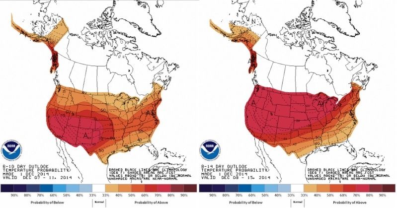
Mike,Math23x7 wrote:NOAA's 6-10 day and 8-14 day temperature outlooks show a better chance of relative warmth from coast to coast than of relative cold. I wonder how they will turn out:
I saw that on the news tonight and looked it up jesus the hole conus torches for God's sake but that should hopefully change the last two weeks.
_________________
Mugs
AKA:King: Snow Weenie
Self Proclaimed
WINTER 2014-15 : 55.12" +.02 for 6 coatings (avg. 35")
WINTER 2015-16 Total - 29.8" (Avg 35")
WINTER 2016-17 : 39.5" so far

amugs- Advanced Forecaster - Mod

- Posts : 15093
Reputation : 213
Join date : 2013-01-07
Age : 54
Location : Hillsdale,NJ
Re: Official Long Range Thread 4.0
![]() by skinsfan1177 Mon Dec 01, 2014 9:34 pm
by skinsfan1177 Mon Dec 01, 2014 9:34 pm

skinsfan1177- Senior Enthusiast
- Posts : 4485
Reputation : 35
Join date : 2013-01-07
Age : 46
Location : Point Pleasant Boro
Re: Official Long Range Thread 4.0
![]() by CPcantmeasuresnow Mon Dec 01, 2014 9:40 pm
by CPcantmeasuresnow Mon Dec 01, 2014 9:40 pm
jmanley32 wrote:Hey Al, yeah doesn't even look all that promising inland, I am trying to take this in heed that its only beginning of December but the current trends have not been good for us and from wehat I have read about a page back things are not setting up good as it looks right now. Of course this can all change in a heartbeat. 70 today just doesn't feel right at all, I'm sorry.
Frank FYI, the Euro does kinda show a coastal like system but it appears to come onshore from the east to west, bringing a lot of snow well inland about a few inches of rain for the coast.
Jman, I'm 40 miles north of you and I barely reached 50 today. The snow took a beating but it still cover the ground in most places. Hard to believe anyone was 70 today. That was some dividing line.

CPcantmeasuresnow- Wx Statistician Guru
- Posts : 7274
Reputation : 230
Join date : 2013-01-07
Age : 103
Location : Eastern Orange County, NY
Re: Official Long Range Thread 4.0
![]() by amugs Mon Dec 01, 2014 9:49 pm
by amugs Mon Dec 01, 2014 9:49 pm
Click on the link you will see the new typhoon heading towards Japan and pretty intense projection as well.
Two LP go up to the GOA and look to cause it to negative and spike the PNA positive in about a week
_________________
Mugs
AKA:King: Snow Weenie
Self Proclaimed
WINTER 2014-15 : 55.12" +.02 for 6 coatings (avg. 35")
WINTER 2015-16 Total - 29.8" (Avg 35")
WINTER 2016-17 : 39.5" so far
amugs- Advanced Forecaster - Mod
- Posts : 15093
Reputation : 213
Join date : 2013-01-07
Age : 54
Location : Hillsdale,NJ
Re: Official Long Range Thread 4.0
![]() by Isotherm Mon Dec 01, 2014 10:35 pm
by Isotherm Mon Dec 01, 2014 10:35 pm
Isotherm- Advanced Forecaster
- Posts : 231
Reputation : 4
Join date : 2014-09-01
Age : 33
Location : Monmouth County, NJ -

Re: Official Long Range Thread 4.0
![]() by Frank_Wx Mon Dec 01, 2014 11:46 pm
by Frank_Wx Mon Dec 01, 2014 11:46 pm

_________________
_______________________________________________________________________________________________________
CLICK HERE to view NJ Strong Snowstorm Classifications

Frank_Wx- Godzilla Seeker

- Posts : 21305
Reputation : 328
Join date : 2013-01-05
Age : 31
Location : Jersey City, NJ -
Re: Official Long Range Thread 4.0
![]() by Frank_Wx Tue Dec 02, 2014 1:04 am
by Frank_Wx Tue Dec 02, 2014 1:04 am
_________________
_______________________________________________________________________________________________________
CLICK HERE to view NJ Strong Snowstorm Classifications
Frank_Wx- Godzilla Seeker
- Posts : 21305
Reputation : 328
Join date : 2013-01-05
Age : 31
Location : Jersey City, NJ -
Re: Official Long Range Thread 4.0
![]() by Math23x7 Tue Dec 02, 2014 1:50 am
by Math23x7 Tue Dec 02, 2014 1:50 am
Now, maybe this December can turn out like December 1998 where the first 22 days were way above average (including 75 degrees on the 7th) and then a cold front occurred and we got a couple of inches of snow on the 24th, giving us a White Christmas. As a then-eight year old, it made me so happy
Math23x7- Wx Statistician Guru
- Posts : 2379
Reputation : 68
Join date : 2013-01-08
Re: Official Long Range Thread 4.0
![]() by HectorO Tue Dec 02, 2014 2:32 am
by HectorO Tue Dec 02, 2014 2:32 am

HectorO- Pro Enthusiast

- Posts : 959
Reputation : 27
Join date : 2013-01-11
Re: Official Long Range Thread 4.0
![]() by docstox12 Tue Dec 02, 2014 4:10 am
by docstox12 Tue Dec 02, 2014 4:10 am
amugs wrote:Mike,Math23x7 wrote:NOAA's 6-10 day and 8-14 day temperature outlooks show a better chance of relative warmth from coast to coast than of relative cold. I wonder how they will turn out:
I saw that on the news tonight and looked it up jesus the hole conus torches for God's sake but that should hopefully change the last two weeks.
Could be Mother Nature reverting back to the mean after the cold November.If it's going to happen, let's get it out of the way in early to mid December rather than January.I like Isotherm's post in another thread where he states that if the above happened, a chance for a White Christmas would be greater.

docstox12- Wx Statistician Guru
- Posts : 8507
Reputation : 222
Join date : 2013-01-07
Age : 73
Location : Monroe NY
Re: Official Long Range Thread 4.0
![]() by algae888 Tue Dec 02, 2014 4:54 am
by algae888 Tue Dec 02, 2014 4:54 am

algae888- Advanced Forecaster
- Posts : 5311
Reputation : 46
Join date : 2013-02-05
Age : 61
Location : mt. vernon, new york
Re: Official Long Range Thread 4.0
![]() by docstox12 Tue Dec 02, 2014 5:14 am
by docstox12 Tue Dec 02, 2014 5:14 am
Many seasons, November through mid-December is mild or average with little or no snow.Many seasons I have seen the winter only get cranking after Christmas.
Math and Hector above mention that they are concerned we could be repeating a 2011-2012 pattern.Anything is possible at this juncture but as math pointed out, Frank waited until mid February to declare that winter busted.We still have over 2 months to get to that point so it's time to watch the atmosphere do it's thing the next month.We also have to see how the December indicator works out ("as Dec goes so goes the winter.").
docstox12- Wx Statistician Guru
- Posts : 8507
Reputation : 222
Join date : 2013-01-07
Age : 73
Location : Monroe NY
Re: Official Long Range Thread 4.0
![]() by HectorO Tue Dec 02, 2014 6:30 am
by HectorO Tue Dec 02, 2014 6:30 am
docstox12 wrote:amugs wrote:Mike,Math23x7 wrote:NOAA's 6-10 day and 8-14 day temperature outlooks show a better chance of relative warmth from coast to coast than of relative cold. I wonder how they will turn out:
I saw that on the news tonight and looked it up jesus the hole conus torches for God's sake but that should hopefully change the last two weeks.
Could be Mother Nature reverting back to the mean after the cold November.If it's going to happen, let's get it out of the way in early to mid December rather than January.I like Isotherm's post in another thread where he states that if the above happened, a chance for a White Christmas would be greater.
My personal opinion is, if it's gonna snow and be cold, I rather have it in December because at least it's for a reason like the holiday season. January is just cruel. And the last 2 Christmas eves we've had snow in mahwah. Last year was like an inch and then year before like half an inch. Not much but it's nice to have it fall during the holidays. After that I'm through with it LOL.
HectorO- Pro Enthusiast
- Posts : 959
Reputation : 27
Join date : 2013-01-11
Re: Official Long Range Thread 4.0
![]() by jmanley32 Tue Dec 02, 2014 7:55 am
by jmanley32 Tue Dec 02, 2014 7:55 am

jmanley32- Senior Enthusiast
- Posts : 20517
Reputation : 108
Join date : 2013-12-12
Age : 42
Location : Yonkers, NY
Re: Official Long Range Thread 4.0
![]() by Quietace Tue Dec 02, 2014 8:43 am
by Quietace Tue Dec 02, 2014 8:43 am
Yeah not happening.jmanley32 wrote:CMC says we get absolutely crushed with an insane amount of rain (up to 10 inches!) and way up north gets 3+ feet or snow (sucks to the max!) But then again it IS the CMC showing two LP form and curve back inland in the 6-10 day. Still do not recall seeing this much rain in a 10 day in a loooong time on any models.

Quietace- Meteorologist - Mod

- Posts : 3687
Reputation : 33
Join date : 2013-01-07
Age : 27
Location : Point Pleasant, NJ
Re: Official Long Range Thread 4.0
![]() by amugs Tue Dec 02, 2014 9:05 am
by amugs Tue Dec 02, 2014 9:05 am
Sorry for the rant but every (good/great) pattern needs to reload folks - just like every great sports team and we are in the reloading period as we saw and knew would happen after the below normal and cold November pattern. Al pointed this out above and timing is good here - let us relax now and then reload around mid month - these take time like a fine bottle of wine!
Isotherm - hot cocoa with my homemade bailey's my friend!!
_________________
Mugs
AKA:King: Snow Weenie
Self Proclaimed
WINTER 2014-15 : 55.12" +.02 for 6 coatings (avg. 35")
WINTER 2015-16 Total - 29.8" (Avg 35")
WINTER 2016-17 : 39.5" so far
amugs- Advanced Forecaster - Mod
- Posts : 15093
Reputation : 213
Join date : 2013-01-07
Age : 54
Location : Hillsdale,NJ
Re: Official Long Range Thread 4.0
![]() by Quietace Tue Dec 02, 2014 9:15 am
by Quietace Tue Dec 02, 2014 9:15 am
Yeah we'll see, we may not see anything meaningful until after the new year.amugs wrote:AS Frank, Tom (Isotherm), Scott (Doc), Al, Doc and I have come to state that December is the transition month into our winter and we have seen mild, benign Decembers turn on a dime and it is all about the pattern and the signs - 2011/12 - no Nino, La Nina, no +PDO, a -PDO, are two telling signs IMO and people freak out and call winter cancelled if we do not have cold and snow in December o rteh models aren't showing anything. We have been totally spoiled by the last few winters and beyond. A great winter doesn't necessarily mean cold and snow from 12-1 until 3-21 ala 95-96 (epic) and the expectations are pretty far fetched - hey would I as a snow weenie love to see that - hell yes BUT the fact is we are not in the mini ice age of the 1600-1700's but in a period where yes it has been cold and snowy since since 2009-10 overall. I can remember many a rainstorm in December and the cold air dives in just after it passes but that is the beauty of nature sometimes - take it with a grain of salt and by no means do I think we cancel winter or say we have 2011-12 setting up - the signals IMO are not the same at all but I am not saying 95-96 either at this point either.
Sorry for the rant but every (good/great) pattern needs to reload folks - just like every great sports team and we are in the reloading period as we saw and knew would happen after the below normal and cold November pattern. Al pointed this out above and timing is good here - let us relax now and then reload around mid month - these take time like a fine bottle of wine!
Isotherm - hot cocoa with my homemade bailey's my friend!!
Quietace- Meteorologist - Mod
- Posts : 3687
Reputation : 33
Join date : 2013-01-07
Age : 27
Location : Point Pleasant, NJ
Re: Official Long Range Thread 4.0
![]() by jmanley32 Tue Dec 02, 2014 9:23 am
by jmanley32 Tue Dec 02, 2014 9:23 am
jmanley32- Senior Enthusiast
- Posts : 20517
Reputation : 108
Join date : 2013-12-12
Age : 42
Location : Yonkers, NY
Re: Official Long Range Thread 4.0
![]() by Frank_Wx Tue Dec 02, 2014 9:50 am
by Frank_Wx Tue Dec 02, 2014 9:50 am

_________________
_______________________________________________________________________________________________________
CLICK HERE to view NJ Strong Snowstorm Classifications
Frank_Wx- Godzilla Seeker
- Posts : 21305
Reputation : 328
Join date : 2013-01-05
Age : 31
Location : Jersey City, NJ -
Re: Official Long Range Thread 4.0
![]() by aiannone Tue Dec 02, 2014 9:58 am
by aiannone Tue Dec 02, 2014 9:58 am
Frank_Wx wrote:Euro ensembles are hideous, though there are a lot of storms ejecting out of the STJ indicative of the El Nino. Again, if you're a winter weather lover take a break the 1st half of December and return around Christmas.
I actually don't mind that lol. It will give me a little time to focus on finals for the next two weeks, though Northern Vermont can surprise you sometimes. Even in the most hideous, warm patterns, we can get snowstorms lol
_________________
-Alex Iannone-

aiannone- Senior Enthusiast - Mod
- Posts : 4814
Reputation : 92
Join date : 2013-01-07
Location : Saint James, LI (Northwest Suffolk Co.)
Re: Official Long Range Thread 4.0
![]() by Frank_Wx Tue Dec 02, 2014 10:15 am
by Frank_Wx Tue Dec 02, 2014 10:15 am
_________________
_______________________________________________________________________________________________________
CLICK HERE to view NJ Strong Snowstorm Classifications
Frank_Wx- Godzilla Seeker
- Posts : 21305
Reputation : 328
Join date : 2013-01-05
Age : 31
Location : Jersey City, NJ -
Re: Official Long Range Thread 4.0
![]() by Frank_Wx Tue Dec 02, 2014 10:21 am
by Frank_Wx Tue Dec 02, 2014 10:21 am

_________________
_______________________________________________________________________________________________________
CLICK HERE to view NJ Strong Snowstorm Classifications
Frank_Wx- Godzilla Seeker
- Posts : 21305
Reputation : 328
Join date : 2013-01-05
Age : 31
Location : Jersey City, NJ -
Re: Official Long Range Thread 4.0
![]() by Snow88 Tue Dec 02, 2014 10:55 am
by Snow88 Tue Dec 02, 2014 10:55 am


Euro is the only one that sends the MJO into the COD


Snow88- Senior Enthusiast
- Posts : 2193
Reputation : 4
Join date : 2013-01-09
Age : 35
Location : Brooklyn, NY
Re: Official Long Range Thread 4.0
![]() by amugs Tue Dec 02, 2014 11:02 am
by amugs Tue Dec 02, 2014 11:02 am
Frank_Wx wrote:Typhoon is expected to slow down and reach super status. Big question is whether or not it recurves
The link I posted last night has it like you said becoming a pretty intense typhoon which is pretty rare at this stage of the season from what I have read and it shows it slowly taking a turn to the NE once it slides by the Philippines but we shall see.
Last edited by amugs on Tue Dec 02, 2014 12:36 pm; edited 1 time in total
_________________
Mugs
AKA:King: Snow Weenie
Self Proclaimed
WINTER 2014-15 : 55.12" +.02 for 6 coatings (avg. 35")
WINTER 2015-16 Total - 29.8" (Avg 35")
WINTER 2016-17 : 39.5" so far
amugs- Advanced Forecaster - Mod
- Posts : 15093
Reputation : 213
Join date : 2013-01-07
Age : 54
Location : Hillsdale,NJ
Page 26 of 42 • 1 ... 14 ... 25, 26, 27 ... 34 ... 42 ![]()
|
|
|