
 Search
Official Long Range Thread 6.0
Page 2 of 40 •  1, 2, 3 ... 21 ... 40
 ![]()
Re: Official Long Range Thread 6.0
![]() by Snow88 Thu Jan 15, 2015 11:20 pm
by Snow88 Thu Jan 15, 2015 11:20 pm
Snow88- Senior Enthusiast

- Posts : 2193
Join date : 2013-01-09
Re: Official Long Range Thread 6.0
![]() by Snow88 Thu Jan 15, 2015 11:32 pm
by Snow88 Thu Jan 15, 2015 11:32 pm
Snow88- Senior Enthusiast
- Posts : 2193
Join date : 2013-01-09
Re: Official Long Range Thread 6.0
![]() by Frank_Wx Thu Jan 15, 2015 11:42 pm
by Frank_Wx Thu Jan 15, 2015 11:42 pm
Snow88 wrote:Next week looks really interesting with a lot of energy running around
Yes, all the players were on the field this run of the 00z GFS. They just did not come together favorably. We're still 8-9 days out. As long as the players are there that is all I care about. No one wants to be in the bulls eye at this range anyway.
Also, 00z GGEM looks like 00z GFS in regards to Sunday storm. Well off the coast.
_________________
_______________________________________________________________________________________________________
CLICK HERE to view NJ Strong Snowstorm Classifications

Frank_Wx- Godzilla Seeker

- Posts : 21305
Reputation : 328
Join date : 2013-01-05
Age : 31
Location : Jersey City, NJ -

Re: Official Long Range Thread 6.0
![]() by Frank_Wx Thu Jan 15, 2015 11:47 pm
by Frank_Wx Thu Jan 15, 2015 11:47 pm
_________________
_______________________________________________________________________________________________________
CLICK HERE to view NJ Strong Snowstorm Classifications
Frank_Wx- Godzilla Seeker
- Posts : 21305
Reputation : 328
Join date : 2013-01-05
Age : 31
Location : Jersey City, NJ -
Re: Official Long Range Thread 6.0
![]() by sroc4 Fri Jan 16, 2015 6:33 am
by sroc4 Fri Jan 16, 2015 6:33 am
[img]
 [/img]
[img]
 [/img]
_________________
"In weather and in life, there's no winning and losing; there's only winning and learning."
WINTER 2012/2013 TOTALS 43.65"WINTER 2017/2018 TOTALS 62.85" WINTER 2022/2023 TOTALS 4.9"
WINTER 2013/2014 TOTALS 64.85"WINTER 2018/2019 TOTALS 14.25" WINTER 2023/2024 TOTALS 13.1"
WINTER 2014/2015 TOTALS 71.20"WINTER 2019/2020 TOTALS 6.35"
WINTER 2015/2016 TOTALS 35.00"WINTER 2020/2021 TOTALS 37.75"
WINTER 2016/2017 TOTALS 42.25"WINTER 2021/2022 TOTALS 31.65"

sroc4- Admin
- Posts : 8331
Reputation : 301
Join date : 2013-01-07
Location : Wading River, LI
Re: Official Long Range Thread 6.0
![]() by sroc4 Fri Jan 16, 2015 6:45 am
by sroc4 Fri Jan 16, 2015 6:45 am
[img]
 [/img]
[img]
 [/img]
_________________
"In weather and in life, there's no winning and losing; there's only winning and learning."
WINTER 2012/2013 TOTALS 43.65"WINTER 2017/2018 TOTALS 62.85" WINTER 2022/2023 TOTALS 4.9"
WINTER 2013/2014 TOTALS 64.85"WINTER 2018/2019 TOTALS 14.25" WINTER 2023/2024 TOTALS 13.1"
WINTER 2014/2015 TOTALS 71.20"WINTER 2019/2020 TOTALS 6.35"
WINTER 2015/2016 TOTALS 35.00"WINTER 2020/2021 TOTALS 37.75"
WINTER 2016/2017 TOTALS 42.25"WINTER 2021/2022 TOTALS 31.65"
sroc4- Admin
- Posts : 8331
Reputation : 301
Join date : 2013-01-07
Location : Wading River, LI
Re: Official Long Range Thread 6.0
![]() by Frank_Wx Fri Jan 16, 2015 7:05 am
by Frank_Wx Fri Jan 16, 2015 7:05 am
The euro is notorious for holding back southern energy. However, the GFS last night was doing the same thing just not to the same degree. Euro digs the northern stream much better though while the GFS is progressive with it. This is all in reference to the 23rd storm.
The 21st storm I'm kinda liking a little bit. There's a 50-50 with a developing western ridge. It would be all northern stream deiven, but if it deepens at the right time we could see a minor to moderate snowfall out of it. What we don't want is for H5 to close off to our west allowing heights to rise along the coast.
_________________
_______________________________________________________________________________________________________
CLICK HERE to view NJ Strong Snowstorm Classifications
Frank_Wx- Godzilla Seeker
- Posts : 21305
Reputation : 328
Join date : 2013-01-05
Age : 31
Location : Jersey City, NJ -
Re: Official Long Range Thread 6.0
![]() by jmanley32 Fri Jan 16, 2015 7:07 am
by jmanley32 Fri Jan 16, 2015 7:07 am

jmanley32- Senior Enthusiast
- Posts : 20513
Reputation : 108
Join date : 2013-12-12
Age : 42
Location : Yonkers, NY
Re: Official Long Range Thread 6.0
![]() by jmanley32 Fri Jan 16, 2015 7:10 am
by jmanley32 Fri Jan 16, 2015 7:10 am
jmanley32- Senior Enthusiast
- Posts : 20513
Reputation : 108
Join date : 2013-12-12
Age : 42
Location : Yonkers, NY
Re: Official Long Range Thread 6.0
![]() by sroc4 Fri Jan 16, 2015 7:16 am
by sroc4 Fri Jan 16, 2015 7:16 am
_________________
"In weather and in life, there's no winning and losing; there's only winning and learning."
WINTER 2012/2013 TOTALS 43.65"WINTER 2017/2018 TOTALS 62.85" WINTER 2022/2023 TOTALS 4.9"
WINTER 2013/2014 TOTALS 64.85"WINTER 2018/2019 TOTALS 14.25" WINTER 2023/2024 TOTALS 13.1"
WINTER 2014/2015 TOTALS 71.20"WINTER 2019/2020 TOTALS 6.35"
WINTER 2015/2016 TOTALS 35.00"WINTER 2020/2021 TOTALS 37.75"
WINTER 2016/2017 TOTALS 42.25"WINTER 2021/2022 TOTALS 31.65"
sroc4- Admin
- Posts : 8331
Reputation : 301
Join date : 2013-01-07
Location : Wading River, LI
Re: Official Long Range Thread 6.0
![]() by jmanley32 Fri Jan 16, 2015 7:28 am
by jmanley32 Fri Jan 16, 2015 7:28 am
jmanley32- Senior Enthusiast
- Posts : 20513
Reputation : 108
Join date : 2013-12-12
Age : 42
Location : Yonkers, NY
Re: Official Long Range Thread 6.0
![]() by sroc4 Fri Jan 16, 2015 9:33 am
by sroc4 Fri Jan 16, 2015 9:33 am
jmanley32 wrote:Yep sroc Euro has about 3-5 for whole area with clipper and even 06z GFS has come bit further south with the snow, but not like the Euro. Asfor the furthest out storm, it keeps showing well south and OTS but something tells me that sucker is going to hit, the Euro ensembles have some HECS runs, MECs and many SECS. Low locations has some of the LP getting down to as low as sub 970! Yes I know we are far off and thats good because if we were close it would be bye bye to that one. What are your thoughts on it sorc? Why is it going S and OTS, rather than up coast like some earlier runs showed, do you think it has a decent shot at changing like many of the ensembles show?
The one thing I will say about the late week system is that if you look at the latest runs of the teleconnections, the AO and NAO in particular you will notice the most recent run does not take either one nearly as neg as it did before. But notice there is also a lot of run to run inconsistency in this. If the NAO is not as strong in the neg state it makes sense to see a further south and east soln as there is not enough blocking to turn it up the coast and bomb. I think both the GFS and Euro are struggling a little bit with exactly where to go with those forecasts. There is no doubt the overall trend is good for us looking in the long range regarding a -NAO and -AO to go along with the -EPO, and +PNA which is forecast. I stand by my 25th-26th time frame. With that said I am not ready to getexcited for the late week system as Im not sure the pattern will be entirely set up for it. We shall see how it goes after the sunday/Monday evvent. Im growing more and more confident of at least something to measure regarding the clipper for Wed. Both the Sunday Monday system, as well as the clipper system will play a big role in the establishment of whatever -NAO or neutral NAO develops for later in the week and beyond. We have to get through the short term and see some consistency before detailed analysis can be done for the later time frame.
EURO/GFS NAO
 " />
" /> " />
" />EURO/GFS AO
 " />
" />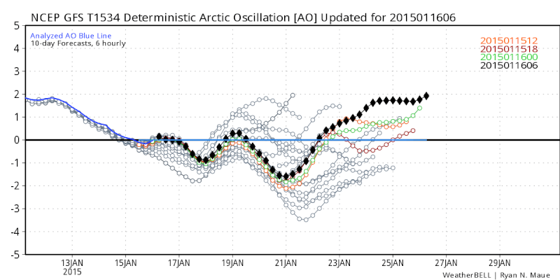 " />
" />_________________
"In weather and in life, there's no winning and losing; there's only winning and learning."
WINTER 2012/2013 TOTALS 43.65"WINTER 2017/2018 TOTALS 62.85" WINTER 2022/2023 TOTALS 4.9"
WINTER 2013/2014 TOTALS 64.85"WINTER 2018/2019 TOTALS 14.25" WINTER 2023/2024 TOTALS 13.1"
WINTER 2014/2015 TOTALS 71.20"WINTER 2019/2020 TOTALS 6.35"
WINTER 2015/2016 TOTALS 35.00"WINTER 2020/2021 TOTALS 37.75"
WINTER 2016/2017 TOTALS 42.25"WINTER 2021/2022 TOTALS 31.65"
sroc4- Admin
- Posts : 8331
Reputation : 301
Join date : 2013-01-07
Location : Wading River, LI
Re: Official Long Range Thread 6.0
![]() by amugs Fri Jan 16, 2015 10:13 am
by amugs Fri Jan 16, 2015 10:13 am
Sunday is a done - rain (?) and 40*'s - some friggin warm up or thaw. Hope it doesn't so I can get my xmass decorations from outside down.
The inconsistency with the NAO and AO are a direct reflection of the changing pattern IMO and it will remain inconsistent - we need to look at the 500mb maps to see what is what and even then hate to say it may not be depicted - the models have been horrid with this this winter.
Wednesday we have a legit shot at a plow able snowstorm with many to come after that.
THIS would be sweeeeetttt!!!

_________________
Mugs
AKA:King: Snow Weenie
Self Proclaimed
WINTER 2014-15 : 55.12" +.02 for 6 coatings (avg. 35")
WINTER 2015-16 Total - 29.8" (Avg 35")
WINTER 2016-17 : 39.5" so far

amugs- Advanced Forecaster - Mod

- Posts : 15093
Reputation : 213
Join date : 2013-01-07
Age : 54
Location : Hillsdale,NJ
Re: Official Long Range Thread 6.0
![]() by jmanley32 Fri Jan 16, 2015 10:22 am
by jmanley32 Fri Jan 16, 2015 10:22 am
jmanley32- Senior Enthusiast
- Posts : 20513
Reputation : 108
Join date : 2013-12-12
Age : 42
Location : Yonkers, NY
Re: Official Long Range Thread 6.0
![]() by Frank_Wx Fri Jan 16, 2015 10:38 am
by Frank_Wx Fri Jan 16, 2015 10:38 am
jmanley32 wrote:So Frank what are you saying about the 23rd, a complete miss? Cuz thats what the Euro showed.
What? Heck no. I can not make such a determination 8 days out. I can only look at the pattern and make an assesement based off of that, which I said I will not do until this weekend. The only storm I suggested will likely be a miss is this Sunday's storm. There is actually another storm on the 21st that needs to be watched before we even get to the 23rd.
So we have the 18th, 21st, and 23rd that we're following.
_________________
_______________________________________________________________________________________________________
CLICK HERE to view NJ Strong Snowstorm Classifications
Frank_Wx- Godzilla Seeker
- Posts : 21305
Reputation : 328
Join date : 2013-01-05
Age : 31
Location : Jersey City, NJ -
Re: Official Long Range Thread 6.0
![]() by Snow88 Fri Jan 16, 2015 11:09 am
by Snow88 Fri Jan 16, 2015 11:09 am

Snow88- Senior Enthusiast
- Posts : 2193
Reputation : 4
Join date : 2013-01-09
Age : 35
Location : Brooklyn, NY
Re: Official Long Range Thread 6.0
![]() by Frank_Wx Fri Jan 16, 2015 11:09 am
by Frank_Wx Fri Jan 16, 2015 11:09 am

The GFS uses the 18th storm as a 50-50 low and really blows it up in SE Canada. This may actually be a problem for the 21st storm because it may not have enough space to amplify and deepen off our coast. The energy kind of gets absorbed a bit into the 18th storm. We have to see how this plays out.
_________________
_______________________________________________________________________________________________________
CLICK HERE to view NJ Strong Snowstorm Classifications
Frank_Wx- Godzilla Seeker
- Posts : 21305
Reputation : 328
Join date : 2013-01-05
Age : 31
Location : Jersey City, NJ -
Re: Official Long Range Thread 6.0
![]() by Guest Fri Jan 16, 2015 11:40 am
by Guest Fri Jan 16, 2015 11:40 am
Last edited by syosnow94 on Fri Jan 16, 2015 12:46 pm; edited 1 time in total
Guest- Guest
Re: Official Long Range Thread 6.0
![]() by Guest Fri Jan 16, 2015 12:10 pm
by Guest Fri Jan 16, 2015 12:10 pm
Can someone please answere my post in the 18th storm thread.
Guest- Guest
Re: Official Long Range Thread 6.0
![]() by algae888 Fri Jan 16, 2015 12:22 pm
by algae888 Fri Jan 16, 2015 12:22 pm

also after going through phase 7 gfs looks like mjo is heading back to 5 and 6. euro also has same look.


algae888- Advanced Forecaster

- Posts : 5311
Reputation : 46
Join date : 2013-02-05
Age : 61
Location : mt. vernon, new york
Re: Official Long Range Thread 6.0
![]() by sroc4 Fri Jan 16, 2015 12:23 pm
by sroc4 Fri Jan 16, 2015 12:23 pm
_________________
"In weather and in life, there's no winning and losing; there's only winning and learning."
WINTER 2012/2013 TOTALS 43.65"WINTER 2017/2018 TOTALS 62.85" WINTER 2022/2023 TOTALS 4.9"
WINTER 2013/2014 TOTALS 64.85"WINTER 2018/2019 TOTALS 14.25" WINTER 2023/2024 TOTALS 13.1"
WINTER 2014/2015 TOTALS 71.20"WINTER 2019/2020 TOTALS 6.35"
WINTER 2015/2016 TOTALS 35.00"WINTER 2020/2021 TOTALS 37.75"
WINTER 2016/2017 TOTALS 42.25"WINTER 2021/2022 TOTALS 31.65"
sroc4- Admin
- Posts : 8331
Reputation : 301
Join date : 2013-01-07
Location : Wading River, LI
Re: Official Long Range Thread 6.0
![]() by skinsfan1177 Fri Jan 16, 2015 12:24 pm
by skinsfan1177 Fri Jan 16, 2015 12:24 pm

skinsfan1177- Senior Enthusiast
- Posts : 4485
Reputation : 35
Join date : 2013-01-07
Age : 46
Location : Point Pleasant Boro
Re: Official Long Range Thread 6.0
![]() by sroc4 Fri Jan 16, 2015 12:27 pm
by sroc4 Fri Jan 16, 2015 12:27 pm
algae888 wrote:well it started on today's 6z and now the 12z but the OP gfs has lost the cold and has plenty of cutters after day 8. looking at it's tele conn. sums up these last 2 runs. after a brief drop in ao/nao gfs seems to think there on the rise again. so much for feb. starting off good. if euro trends towards gfs then it's time to write off this winter.
also after going through phase 7 gfs looks like mjo is heading back to 5 and 6. euro also has same look.
I like this one the best Al
http://www.cpc.ncep.noaa.gov/products/precip/CWlink/MJO/CLIVAR/clivar_wh.shtml

_________________
"In weather and in life, there's no winning and losing; there's only winning and learning."
WINTER 2012/2013 TOTALS 43.65"WINTER 2017/2018 TOTALS 62.85" WINTER 2022/2023 TOTALS 4.9"
WINTER 2013/2014 TOTALS 64.85"WINTER 2018/2019 TOTALS 14.25" WINTER 2023/2024 TOTALS 13.1"
WINTER 2014/2015 TOTALS 71.20"WINTER 2019/2020 TOTALS 6.35"
WINTER 2015/2016 TOTALS 35.00"WINTER 2020/2021 TOTALS 37.75"
WINTER 2016/2017 TOTALS 42.25"WINTER 2021/2022 TOTALS 31.65"
sroc4- Admin
- Posts : 8331
Reputation : 301
Join date : 2013-01-07
Location : Wading River, LI
Re: Official Long Range Thread 6.0
![]() by algae888 Fri Jan 16, 2015 12:31 pm
by algae888 Fri Jan 16, 2015 12:31 pm
algae888- Advanced Forecaster
- Posts : 5311
Reputation : 46
Join date : 2013-02-05
Age : 61
Location : mt. vernon, new york
Re: Official Long Range Thread 6.0
![]() by Frank_Wx Fri Jan 16, 2015 12:50 pm
by Frank_Wx Fri Jan 16, 2015 12:50 pm

_________________
_______________________________________________________________________________________________________
CLICK HERE to view NJ Strong Snowstorm Classifications
Frank_Wx- Godzilla Seeker
- Posts : 21305
Reputation : 328
Join date : 2013-01-05
Age : 31
Location : Jersey City, NJ -
Re: Official Long Range Thread 6.0
![]() by algae888 Fri Jan 16, 2015 12:57 pm
by algae888 Fri Jan 16, 2015 12:57 pm


gfs is wayyyy different.
algae888- Advanced Forecaster
- Posts : 5311
Reputation : 46
Join date : 2013-02-05
Age : 61
Location : mt. vernon, new york
Re: Official Long Range Thread 6.0
![]() by Frank_Wx Fri Jan 16, 2015 1:19 pm
by Frank_Wx Fri Jan 16, 2015 1:19 pm

_________________
_______________________________________________________________________________________________________
CLICK HERE to view NJ Strong Snowstorm Classifications
Frank_Wx- Godzilla Seeker
- Posts : 21305
Reputation : 328
Join date : 2013-01-05
Age : 31
Location : Jersey City, NJ -
Page 2 of 40 • 1, 2, 3 ... 21 ... 40 ![]()
|
|
|