
 Search
Official Long Range Thread 6.0
Page 29 of 40 •  1 ... 16 ... 28, 29, 30 ... 34 ... 40
 ![]()
Re: Official Long Range Thread 6.0
![]() by Frank_Wx Sun Feb 08, 2015 7:42 pm
by Frank_Wx Sun Feb 08, 2015 7:42 pm
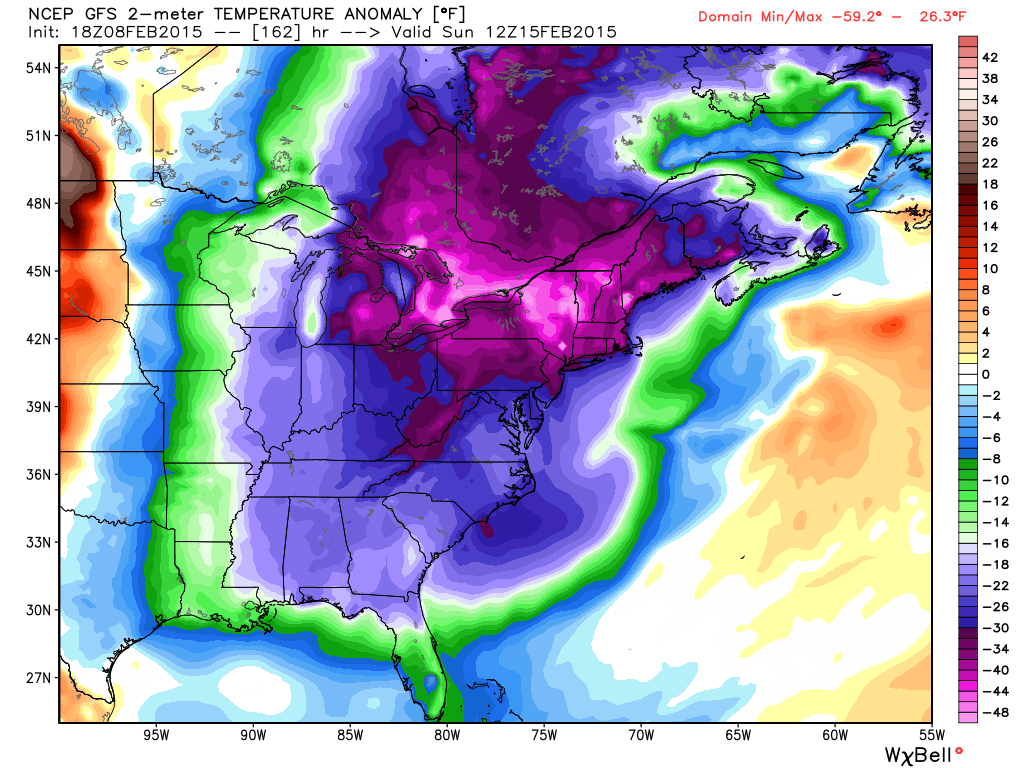
GFS:
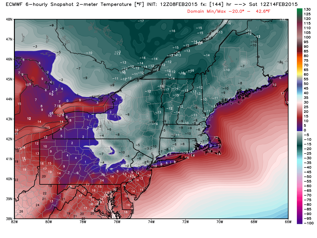
EURO for Saturday morning
Frank_Wx- Godzilla Seeker

- Posts : 21305
Join date : 2013-01-05 -

Frank_Wx- Godzilla Seeker
- Posts : 21305
Join date : 2013-01-05 -
Re: Official Long Range Thread 6.0
![]() by Frank_Wx Sun Feb 08, 2015 7:45 pm
by Frank_Wx Sun Feb 08, 2015 7:45 pm
Madonne.
_________________
_______________________________________________________________________________________________________
CLICK HERE to view NJ Strong Snowstorm Classifications

Frank_Wx- Godzilla Seeker
- Posts : 21305
Reputation : 328
Join date : 2013-01-05
Age : 31
Location : Jersey City, NJ -
Re: Official Long Range Thread 6.0
![]() by Frank_Wx Sun Feb 08, 2015 7:46 pm
by Frank_Wx Sun Feb 08, 2015 7:46 pm
_________________
_______________________________________________________________________________________________________
CLICK HERE to view NJ Strong Snowstorm Classifications
Frank_Wx- Godzilla Seeker
- Posts : 21305
Reputation : 328
Join date : 2013-01-05
Age : 31
Location : Jersey City, NJ -
Re: Official Long Range Thread 6.0
![]() by Frank_Wx Sun Feb 08, 2015 7:53 pm
by Frank_Wx Sun Feb 08, 2015 7:53 pm

_________________
_______________________________________________________________________________________________________
CLICK HERE to view NJ Strong Snowstorm Classifications
Frank_Wx- Godzilla Seeker
- Posts : 21305
Reputation : 328
Join date : 2013-01-05
Age : 31
Location : Jersey City, NJ -
Re: Official Long Range Thread 6.0
![]() by skinsfan1177 Sun Feb 08, 2015 8:05 pm
by skinsfan1177 Sun Feb 08, 2015 8:05 pm

skinsfan1177- Senior Enthusiast

- Posts : 4485
Reputation : 35
Join date : 2013-01-07
Age : 46
Location : Point Pleasant Boro
Re: Official Long Range Thread 6.0
![]() by jmanley32 Mon Feb 09, 2015 12:37 am
by jmanley32 Mon Feb 09, 2015 12:37 am

jmanley32- Senior Enthusiast
- Posts : 20516
Reputation : 108
Join date : 2013-12-12
Age : 42
Location : Yonkers, NY
Re: Official Long Range Thread 6.0
![]() by algae888 Mon Feb 09, 2015 1:37 am
by algae888 Mon Feb 09, 2015 1:37 am

algae888- Advanced Forecaster

- Posts : 5311
Reputation : 46
Join date : 2013-02-05
Age : 61
Location : mt. vernon, new york
Re: Official Long Range Thread 6.0
![]() by jmanley32 Mon Feb 09, 2015 2:21 am
by jmanley32 Mon Feb 09, 2015 2:21 am
jmanley32- Senior Enthusiast
- Posts : 20516
Reputation : 108
Join date : 2013-12-12
Age : 42
Location : Yonkers, NY
Re: Official Long Range Thread 6.0
![]() by Guest Mon Feb 09, 2015 7:49 am
by Guest Mon Feb 09, 2015 7:49 am
Guest- Guest
Re: Official Long Range Thread 6.0
![]() by docstox12 Mon Feb 09, 2015 8:01 am
by docstox12 Mon Feb 09, 2015 8:01 am
syosnow94 wrote:Clipper track has trended north of the area for Thursday, but with high ratios should be a 6-8" storm..............................FOR BOSTON!!
This is like watching a baseball game where the opposing team cycles through their batting order against your pitchers! They hit every pitch you throw at them.Guess it was just in the cards that the pattern would favor Boston.Miller B's always perform better N and E of us and this winter tells the tale.

docstox12- Wx Statistician Guru

- Posts : 8504
Reputation : 222
Join date : 2013-01-07
Age : 73
Location : Monroe NY
Re: Official Long Range Thread 6.0
![]() by crippo84 Mon Feb 09, 2015 9:32 am
by crippo84 Mon Feb 09, 2015 9:32 am
Maybe it's a good thing not to be in the crosshairs at this timeframe. We see how our previous events have trended as we get closer when we're in the bullseye too early. Obviously just hoping at this point...maybe we can get the late trend in our direction this time lol.algae888 wrote:euro looks very interesting for thurs and sat. only have ewall maps they do not tell all details but looks promising,

crippo84- Posts : 383
Reputation : 20
Join date : 2013-11-07
Age : 40
Location : East Village, NYC
Re: Official Long Range Thread 6.0
![]() by Guest Mon Feb 09, 2015 9:55 am
by Guest Mon Feb 09, 2015 9:55 am
crippo84 wrote:Maybe it's a good thing not to be in the crosshairs at this timeframe. We see how our previous events have trended as we get closer when we're in the bullseye too early. Obviously just hoping at this point...maybe we can get the late trend in our direction this time lol.algae888 wrote:euro looks very interesting for thurs and sat. only have ewall maps they do not tell all details but looks promising,
Almost impossible when we're talking about a clipper. The forecast track shifted north (shocker) from yesterdays runs by over 150 miles putting our friends in Boston under about .50 QPF with 20 to 1 ratios. We get maybe .1 QPF! !
Guest- Guest
Re: Official Long Range Thread 6.0
![]() by RJB8525 Mon Feb 09, 2015 10:00 am
by RJB8525 Mon Feb 09, 2015 10:00 am
Edit: if someone can delete this i meant to post this in the OBS thread LOL
Last edited by RJB8525 on Mon Feb 09, 2015 10:01 am; edited 1 time in total

RJB8525- Senior Enthusiast
- Posts : 1994
Reputation : 28
Join date : 2013-02-06
Age : 38
Location : Hackettstown, NJ
Re: Official Long Range Thread 6.0
![]() by crippo84 Mon Feb 09, 2015 10:00 am
by crippo84 Mon Feb 09, 2015 10:00 am
Lol yeah...again just hoping/wishing. It looks like it's a transfer of energy type of storm, just too late for us. But FWIW, the 06z GFS took a very nice trend in our direction. Nothing huge but decent QPF with cold air. But...it's just the 06z GFS. East end of LI would be in good shape with that run verbatim however.syosnow94 wrote:crippo84 wrote:Maybe it's a good thing not to be in the crosshairs at this timeframe. We see how our previous events have trended as we get closer when we're in the bullseye too early. Obviously just hoping at this point...maybe we can get the late trend in our direction this time lol.algae888 wrote:euro looks very interesting for thurs and sat. only have ewall maps they do not tell all details but looks promising,
Almost impossible when we're talking about a clipper. The forecast track shifted north (shocker) from yesterdays runs by over 150 miles putting our friends in Boston under about .50 QPF with 20 to 1 ratios. We get maybe .1 QPF! !
crippo84- Posts : 383
Reputation : 20
Join date : 2013-11-07
Age : 40
Location : East Village, NYC
Re: Official Long Range Thread 6.0
![]() by rb924119 Mon Feb 09, 2015 11:02 am
by rb924119 Mon Feb 09, 2015 11:02 am
rb924119- Meteorologist

- Posts : 6890
Reputation : 194
Join date : 2013-02-06
Age : 32
Location : Greentown, Pa
Re: Official Long Range Thread 6.0
![]() by Frank_Wx Mon Feb 09, 2015 11:07 am
by Frank_Wx Mon Feb 09, 2015 11:07 am
_________________
_______________________________________________________________________________________________________
CLICK HERE to view NJ Strong Snowstorm Classifications
Frank_Wx- Godzilla Seeker
- Posts : 21305
Reputation : 328
Join date : 2013-01-05
Age : 31
Location : Jersey City, NJ -
Re: Official Long Range Thread 6.0
![]() by jimv45 Mon Feb 09, 2015 11:09 am
by jimv45 Mon Feb 09, 2015 11:09 am
jimv45- Senior Enthusiast
- Posts : 1168
Reputation : 36
Join date : 2013-09-20
Location : Hopewell jct.
Re: Official Long Range Thread 6.0
![]() by CPcantmeasuresnow Mon Feb 09, 2015 11:10 am
by CPcantmeasuresnow Mon Feb 09, 2015 11:10 am
rb924119 wrote:Latest GFS run crushes the east end of LI and whaddya know; Boston too lol
The pattern will turn on them eventually just like it did for us out of the blue on February 17th last year, but what a run they've had no doubt. Some places may see double their seasonal average in a 20 day period.
Last edited by CPcantmeasuresnow on Mon Feb 09, 2015 11:16 am; edited 1 time in total

CPcantmeasuresnow- Wx Statistician Guru
- Posts : 7274
Reputation : 230
Join date : 2013-01-07
Age : 103
Location : Eastern Orange County, NY
Re: Official Long Range Thread 6.0
![]() by RJB8525 Mon Feb 09, 2015 11:10 am
by RJB8525 Mon Feb 09, 2015 11:10 am
Frank_Wx wrote:The Thursday storm with each model run is trending stronger and slightly west. Getting a little interesting. Still thinking minor snowfall at this point but that could quickly change
a quick hit system maybe 2-3" would be nice.
RJB8525- Senior Enthusiast
- Posts : 1994
Reputation : 28
Join date : 2013-02-06
Age : 38
Location : Hackettstown, NJ
Re: Official Long Range Thread 6.0
![]() by Frank_Wx Mon Feb 09, 2015 11:13 am
by Frank_Wx Mon Feb 09, 2015 11:13 am


High ratio too
_________________
_______________________________________________________________________________________________________
CLICK HERE to view NJ Strong Snowstorm Classifications
Frank_Wx- Godzilla Seeker
- Posts : 21305
Reputation : 328
Join date : 2013-01-05
Age : 31
Location : Jersey City, NJ -
Re: Official Long Range Thread 6.0
![]() by amugs Mon Feb 09, 2015 11:18 am
by amugs Mon Feb 09, 2015 11:18 am
If it verifies NENJ gets in teh action and does the NJ coast


Last edited by amugs on Mon Feb 09, 2015 11:21 am; edited 1 time in total
_________________
Mugs
AKA:King: Snow Weenie
Self Proclaimed
WINTER 2014-15 : 55.12" +.02 for 6 coatings (avg. 35")
WINTER 2015-16 Total - 29.8" (Avg 35")
WINTER 2016-17 : 39.5" so far

amugs- Advanced Forecaster - Mod

- Posts : 15093
Reputation : 213
Join date : 2013-01-07
Age : 54
Location : Hillsdale,NJ
Re: Official Long Range Thread 6.0
![]() by jimv45 Mon Feb 09, 2015 11:18 am
by jimv45 Mon Feb 09, 2015 11:18 am
jimv45- Senior Enthusiast
- Posts : 1168
Reputation : 36
Join date : 2013-09-20
Location : Hopewell jct.
Re: Official Long Range Thread 6.0
![]() by CPcantmeasuresnow Mon Feb 09, 2015 11:24 am
by CPcantmeasuresnow Mon Feb 09, 2015 11:24 am
CPcantmeasuresnow- Wx Statistician Guru
- Posts : 7274
Reputation : 230
Join date : 2013-01-07
Age : 103
Location : Eastern Orange County, NY
Re: Official Long Range Thread 6.0
![]() by Frank_Wx Mon Feb 09, 2015 11:26 am
by Frank_Wx Mon Feb 09, 2015 11:26 am
CPcantmeasuresnow wrote:I'm actually glad we're not in the bullseye right now. Being in the bullseye four days out has not worked out in any storms this season so maybe at this stage this is a good thing.
Yea, but I would not get your hopes up for this event. Pattern still favors eastern LI/southern NE. We'll see if this trends west but we should be happy with even a minor snowfall event
_________________
_______________________________________________________________________________________________________
CLICK HERE to view NJ Strong Snowstorm Classifications
Frank_Wx- Godzilla Seeker
- Posts : 21305
Reputation : 328
Join date : 2013-01-05
Age : 31
Location : Jersey City, NJ -
Re: Official Long Range Thread 6.0
![]() by devsman Mon Feb 09, 2015 11:29 am
by devsman Mon Feb 09, 2015 11:29 am

devsman- Pro Enthusiast

- Posts : 424
Reputation : 4
Join date : 2014-01-01
Age : 48
Location : merrick, ny (south shore of Long Island)
Re: Official Long Range Thread 6.0
![]() by CPcantmeasuresnow Mon Feb 09, 2015 11:30 am
by CPcantmeasuresnow Mon Feb 09, 2015 11:30 am
Frank_Wx wrote:CPcantmeasuresnow wrote:I'm actually glad we're not in the bullseye right now. Being in the bullseye four days out has not worked out in any storms this season so maybe at this stage this is a good thing.
Yea, but I would not get your hopes up for this event. Pattern still favors eastern LI/southern NE. We'll see if this trends west but we should be happy with even a minor snowfall event
Agreed, but maybe this one can work out for NYC on east. It doesn't look like a HV special by any means.
CPcantmeasuresnow- Wx Statistician Guru
- Posts : 7274
Reputation : 230
Join date : 2013-01-07
Age : 103
Location : Eastern Orange County, NY
Page 29 of 40 • 1 ... 16 ... 28, 29, 30 ... 34 ... 40 ![]()
|
|
|