
 Search
Update #4: Final Call Snow Map
Page 34 of 40 •  1 ... 18 ... 33, 34, 35 ... 40
 ![]()
Re: Update #4: Final Call Snow Map
![]() by skinsfan1177 Sun Jan 25, 2015 5:14 am
by skinsfan1177 Sun Jan 25, 2015 5:14 am
skinsfan1177- Senior Enthusiast

- Posts : 4485
Join date : 2013-01-07
Re: Update #4: Final Call Snow Map
![]() by SoulSingMG Sun Jan 25, 2015 5:20 am
by SoulSingMG Sun Jan 25, 2015 5:20 am

SoulSingMG- Senior Enthusiast
- Posts : 2853
Join date : 2013-12-11
Re: Update #4: Final Call Snow Map
![]() by WOLVES1 Sun Jan 25, 2015 5:23 am
by WOLVES1 Sun Jan 25, 2015 5:23 am

WOLVES1- Posts : 103
Reputation : 0
Join date : 2013-01-10
Age : 52
Location : Malverne NY
Re: Update #4: Final Call Snow Map
![]() by SoulSingMG Sun Jan 25, 2015 5:25 am
by SoulSingMG Sun Jan 25, 2015 5:25 am
WOLVES1 wrote:Have a snow blower question, I have a toro snow blower the one with the rubber blade, and I think about 13 inch height. With strong winds would it be worth it to go out every couple of hours to clear snow or just wait till its finished?
Not with the kind of wind we're expecting. There's going to be SEVERE blowing and drifting. Just wait and save yourself the hourly headaches.

SoulSingMG- Senior Enthusiast
- Posts : 2853
Reputation : 74
Join date : 2013-12-11
Location : Long Island City, NY
Re: Update #4: Final Call Snow Map
![]() by SoulSingMG Sun Jan 25, 2015 5:27 am
by SoulSingMG Sun Jan 25, 2015 5:27 am
SoulSingMG- Senior Enthusiast
- Posts : 2853
Reputation : 74
Join date : 2013-12-11
Location : Long Island City, NY
Re: Update #4: Final Call Snow Map
![]() by skinsfan1177 Sun Jan 25, 2015 5:31 am
by skinsfan1177 Sun Jan 25, 2015 5:31 am

skinsfan1177- Senior Enthusiast
- Posts : 4485
Reputation : 35
Join date : 2013-01-07
Age : 46
Location : Point Pleasant Boro
Re: Update #4: Final Call Snow Map
![]() by WOLVES1 Sun Jan 25, 2015 5:31 am
by WOLVES1 Sun Jan 25, 2015 5:31 am
Thanks that's what I was thinking.SoulSingMG wrote:WOLVES1 wrote:Have a snow blower question, I have a toro snow blower the one with the rubber blade, and I think about 13 inch height. With strong winds would it be worth it to go out every couple of hours to clear snow or just wait till its finished?
Not with the kind of wind we're expecting. There's going to be SEVERE blowing and drifting. Just wait and save yourself the hourly headaches.
WOLVES1- Posts : 103
Reputation : 0
Join date : 2013-01-10
Age : 52
Location : Malverne NY
Re: Update #4: Final Call Snow Map
![]() by SoulSingMG Sun Jan 25, 2015 5:32 am
by SoulSingMG Sun Jan 25, 2015 5:32 am
.SHORT TERM /6 PM THIS EVENING THROUGH TUESDAY NIGHT/...
HIGH PRESSURE NOSES IN FROM THE NW TONIGHT WITH CLOUDS GRADUALLY
LOWERING AND THICKENING AHEAD OF A CLIPPER LOW MOVING ACROSS THE
OHIO VALLEY. WARM ADVECTION AHEAD OF THE SYSTEM MAY ALLOW FOR
LIGHT SNOW AND/OR FLURRIES TO WORK INTO THE AREA PRIOR TO DAYBREAK
MON.
THE INGREDIENTS ARE THEN COMING TOGETHER FOR A POSSIBLE HISTORIC
NOR`EASTER AS A SECONDARY LOW FORMS OFF THE MID ATLANTIC EARLY MON.
THIS LOW UNDERGOES RAPID INTENSIFICATION AS THE LOW CUTS OFF ALOFT
NEAR THE MID ATLANTIC MON NIGHT...LIFTING SLOWLY NORTHWARD THROUGH
TUE NIGHT. MSLP DROPS NEARLY 30 MB IN 24H FROM MON TO TUE
MORNING...BEFORE GRADUALLY FILLING. THIS WILL PLACE THE FORECAST
AREA ON THE NW FLANK OF THE LOW WITH A PROLONGED PERIOD OF MDT-HVY
SNOW IN THE DEFORMATION ZONE. MOST OF THE GLOBAL MODELS AND THEIR
ENSEMBLE MEMBERS MEMBERS SUPPORTS UPWARDS OF 2 INCHES LIQUID
EQUIVALENT...WITH THE HIGHEST AMOUNTS ACROSS EASTERN LI/SE CT.
THAT BEING THE CASE...SNOW BANDING WILL LIKELY EXTEND AS FAR WEST
AS THE LOWER HUDSON VALLEY WITH SNOWFALL RATES OF 2 TO 4 INCHES AN
HOUR AT TIMES. MUCH OF THE AREA SHOULD SEE A FOOT WITH AMOUNTS AS
HIGH AS 2 FT POSSIBLE ACROSS EASTERN LI/SE CT. ONCE AGAIN
THOUGH...THE EXACT LOCATION OF THE MOST INTENSE BANDING IS
DIFFICULT TO PINPOINT AT THIS JUNCTURE.
THE 00Z NAM CONTINUES TO BE AN OUTLIER ON THE EASTERN FLANK OF
THE LOW TRACK AND ITS SIGNIFICANTLY LOWER PCPN HAS BEEN
DISCOUNTED.
IN ADDITION...THE DEEP LOW PRESSURE COMBINED WITH STRONG HIGH
PRESSURE TO THE NORTH AND WEST WILL CREATE NEAR OR BLIZZARD
CONDITIONS ACROSS MUCH OF THE REGION. A BLIZZARD WATCH HAS BEEN
POSTED FOR LI AND MUCH OF THE SOUTHERN CT...WITH A WINTER STORM
WATCH ELSEWHERE. POTENTIAL EXISTS FOR GUST OF 35 TO 50
MPH...HIGHEST TO THE EAST.
LIGHT SNOW DEVELOPS MON MORNING AND THEN GRADUALLY PICKS UP IN THE
LATE AFT. MDT-HVY SNOW WILL FALL FOR MUCH OF MON NIGHT INTO TUE
BEFORE TAPERING OFF TUE EVENING.
TEMPS DURING THE STORM WILL GENERALLY BE IN THE 20S WITH WIND
CHILLS IN THE SINGLE DIGITS TO MID TEENS.
SoulSingMG- Senior Enthusiast
- Posts : 2853
Reputation : 74
Join date : 2013-12-11
Location : Long Island City, NY
Re: Update #4: Final Call Snow Map
![]() by skinsfan1177 Sun Jan 25, 2015 5:40 am
by skinsfan1177 Sun Jan 25, 2015 5:40 am
skinsfan1177- Senior Enthusiast
- Posts : 4485
Reputation : 35
Join date : 2013-01-07
Age : 46
Location : Point Pleasant Boro
Re: Update #4: Final Call Snow Map
![]() by SNOW MAN Sun Jan 25, 2015 5:42 am
by SNOW MAN Sun Jan 25, 2015 5:42 am
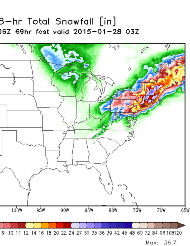
CPcantmeasuresnow wrote:Frank_Wx wrote:This map takes into account ratios and shows 40+ inches for NYC
This is the last Euro run which takes into account ratios. It shows 40 inches for NYC.
We shall see. It would break the record if so.

Cp as usual my local Met is calling for 1-4in for Monday and 1-2in for Tuesday. I know my area won't get amounts like areas East of me, but 1-2in come on.
Just checked Inaccuweather and the NWS has already posted a WSW for my area for 6-16inches of snow. Local Met didn't even mention WSW. Unbelievable.
Last edited by SNOW MAN on Sun Jan 25, 2015 5:52 am; edited 1 time in total

SNOW MAN- Senior Enthusiast
- Posts : 1361
Reputation : 25
Join date : 2013-01-13
Age : 64
Location : Marshalls Creek Pa.
Re: Update #4: Final Call Snow Map
![]() by CPcantmeasuresnow Sun Jan 25, 2015 5:49 am
by CPcantmeasuresnow Sun Jan 25, 2015 5:49 am
We've had several storms in the last 10 years where many parts of our area saw over 30 inches of snow. I received 35 inches from the February 2010 blizzard but I don't think we've seen anything with this widespread an area of possibly 20 inches or more since the 2003 PD storm.
I hope it all plays out as it currently shows on Euro. If so records may fall.

CPcantmeasuresnow- Wx Statistician Guru

- Posts : 7274
Reputation : 230
Join date : 2013-01-07
Age : 103
Location : Eastern Orange County, NY
Re: Update #4: Final Call Snow Map
![]() by CPcantmeasuresnow Sun Jan 25, 2015 5:53 am
by CPcantmeasuresnow Sun Jan 25, 2015 5:53 am
CPcantmeasuresnow- Wx Statistician Guru
- Posts : 7274
Reputation : 230
Join date : 2013-01-07
Age : 103
Location : Eastern Orange County, NY
Re: Update #4: Final Call Snow Map
![]() by SNOW MAN Sun Jan 25, 2015 5:58 am
by SNOW MAN Sun Jan 25, 2015 5:58 am
CPcantmeasuresnow wrote:Snow man. That local met of yours is becoming as legendary as the zookeeper for his low snowfall totals. Is he actually a meteorologist or does he just play one on TV.
I don't know, but I think they slept at a Holiday Inn once.
Yesterday they only called for 1-2in and we really ended up with 7.5. So when the gave their forecast yesterday morning they upped their totals to 4-6in after the storm was already over.
SNOW MAN- Senior Enthusiast
- Posts : 1361
Reputation : 25
Join date : 2013-01-13
Age : 64
Location : Marshalls Creek Pa.
Re: Update #4: Final Call Snow Map
![]() by algae888 Sun Jan 25, 2015 6:02 am
by algae888 Sun Jan 25, 2015 6:02 am
nws seems to be conservative with their snow totals as of now as they undercut mod output by at least 6". plus they are using straight 10:1 ratios which I think is a mistake. look for nws snow totals to go up if 12z suite hold firm

algae888- Advanced Forecaster

- Posts : 5311
Reputation : 46
Join date : 2013-02-05
Age : 61
Location : mt. vernon, new york
Re: Update #4: Final Call Snow Map
![]() by algae888 Sun Jan 25, 2015 6:06 am
by algae888 Sun Jan 25, 2015 6:06 am
algae888- Advanced Forecaster
- Posts : 5311
Reputation : 46
Join date : 2013-02-05
Age : 61
Location : mt. vernon, new york
Re: Update #4: Final Call Snow Map
![]() by skinsfan1177 Sun Jan 25, 2015 6:06 am
by skinsfan1177 Sun Jan 25, 2015 6:06 am
skinsfan1177- Senior Enthusiast
- Posts : 4485
Reputation : 35
Join date : 2013-01-07
Age : 46
Location : Point Pleasant Boro
Re: Update #4: Final Call Snow Map
![]() by skinsfan1177 Sun Jan 25, 2015 6:07 am
by skinsfan1177 Sun Jan 25, 2015 6:07 am
skinsfan1177- Senior Enthusiast
- Posts : 4485
Reputation : 35
Join date : 2013-01-07
Age : 46
Location : Point Pleasant Boro
Re: Update #4: Final Call Snow Map
![]() by SNOW MAN Sun Jan 25, 2015 6:08 am
by SNOW MAN Sun Jan 25, 2015 6:08 am
SNOW MAN- Senior Enthusiast
- Posts : 1361
Reputation : 25
Join date : 2013-01-13
Age : 64
Location : Marshalls Creek Pa.
Re: Update #4: Final Call Snow Map
![]() by algae888 Sun Jan 25, 2015 6:09 am
by algae888 Sun Jan 25, 2015 6:09 am
Last edited by algae888 on Sun Jan 25, 2015 6:18 am; edited 1 time in total
algae888- Advanced Forecaster
- Posts : 5311
Reputation : 46
Join date : 2013-02-05
Age : 61
Location : mt. vernon, new york
Re: Update #4: Final Call Snow Map
![]() by CPcantmeasuresnow Sun Jan 25, 2015 6:09 am
by CPcantmeasuresnow Sun Jan 25, 2015 6:09 am
SNOW MAN wrote:CPcantmeasuresnow wrote:Snow man. That local met of yours is becoming as legendary as the zookeeper for his low snowfall totals. Is he actually a meteorologist or does he just play one on TV.
I don't know, but I think they slept at a Holiday Inn once.
Yesterday they only called for 1-2in and we really ended up with 7.5. So when the gave their forecast yesterday morning they upped their totals to 4-6in after the storm was already over.
I think he just issued your area a WSW for yesterday.
CPcantmeasuresnow- Wx Statistician Guru
- Posts : 7274
Reputation : 230
Join date : 2013-01-07
Age : 103
Location : Eastern Orange County, NY
Re: Update #4: Final Call Snow Map
![]() by algae888 Sun Jan 25, 2015 6:12 am
by algae888 Sun Jan 25, 2015 6:12 am
tku and WOW I can't believe what we are looking at here EPIC if this pans out. wow is this winter turning aroundSNOW MAN wrote:Algae, congrats on being made a moderator on this board. Frank made an excellent choice.
algae888- Advanced Forecaster
- Posts : 5311
Reputation : 46
Join date : 2013-02-05
Age : 61
Location : mt. vernon, new york
Re: Update #4: Final Call Snow Map
![]() by CPcantmeasuresnow Sun Jan 25, 2015 6:13 am
by CPcantmeasuresnow Sun Jan 25, 2015 6:13 am
algae888 wrote:cp and snowman you may have 15 or higher ratios to make up for less qpf so I wouldn't be to concerned that you will miss out this storm. obviously east is best here at this time but I am fairly confident most of area will see 1-2" of snow with some higher amounts
Al I'm due north of midtown about 50 miles so right now I'm on edge of Euro bulls eye. Snow in eastern PA more of a concern right now but he should do fine too.
CPcantmeasuresnow- Wx Statistician Guru
- Posts : 7274
Reputation : 230
Join date : 2013-01-07
Age : 103
Location : Eastern Orange County, NY
Re: Update #4: Final Call Snow Map
![]() by algae888 Sun Jan 25, 2015 6:15 am
by algae888 Sun Jan 25, 2015 6:15 am

only goes out 48hrs and looks a little east of other models

algae888- Advanced Forecaster
- Posts : 5311
Reputation : 46
Join date : 2013-02-05
Age : 61
Location : mt. vernon, new york
Re: Update #4: Final Call Snow Map
![]() by bloc1357 Sun Jan 25, 2015 6:15 am
by bloc1357 Sun Jan 25, 2015 6:15 am
bloc1357- Pro Enthusiast

- Posts : 344
Reputation : 10
Join date : 2013-03-05
Age : 47
Location : West Babylon, NY - 11704
Re: Update #4: Final Call Snow Map
![]() by CPcantmeasuresnow Sun Jan 25, 2015 6:16 am
by CPcantmeasuresnow Sun Jan 25, 2015 6:16 am
skinsfan1177 wrote:Euro map shows 24 inches now is that 10:1 ratios
The euro map I reposted from Franks post last night has the higher ratios factored in. It has 40 inches for NYC.
CPcantmeasuresnow- Wx Statistician Guru
- Posts : 7274
Reputation : 230
Join date : 2013-01-07
Age : 103
Location : Eastern Orange County, NY
Re: Update #4: Final Call Snow Map
![]() by SNOW MAN Sun Jan 25, 2015 6:17 am
by SNOW MAN Sun Jan 25, 2015 6:17 am
algae888 wrote:cp and snowman you may have 15 or higher ratios to make up for less qpf so I wouldn't be to concerned that you will miss out this storm. obviously east is best here at this time but I am fairly confident most of area will see 1-2" of snow with some higher amounts
Al, I hope you mean 1-2 feet. Your post says 1-2inches. That's sound like the local Met in my areas forecast. You must be tired. LOL !
lolyes I just corrected that
Last edited by SNOW MAN on Sun Jan 25, 2015 6:17 am; edited 1 time in total
SNOW MAN- Senior Enthusiast
- Posts : 1361
Reputation : 25
Join date : 2013-01-13
Age : 64
Location : Marshalls Creek Pa.
Re: Update #4: Final Call Snow Map
![]() by algae888 Sun Jan 25, 2015 6:17 am
by algae888 Sun Jan 25, 2015 6:17 am
algae888- Advanced Forecaster
- Posts : 5311
Reputation : 46
Join date : 2013-02-05
Age : 61
Location : mt. vernon, new york
Page 34 of 40 • 1 ... 18 ... 33, 34, 35 ... 40 ![]()
|
|
|