
 Search
Updated Snow Map & Observations Thread, 2/1-2/2 Storm
Page 3 of 30 •  1, 2, 3, 4 ... 16 ... 30
 ![]()
Re: Updated Snow Map & Observations Thread, 2/1-2/2 Storm
![]() by jmanley32 Sun Feb 01, 2015 4:39 pm
by jmanley32 Sun Feb 01, 2015 4:39 pm
NORTHERN MIDDLESEX-NORTHERN NEW LONDON-SOUTHERN FAIRFIELD-
SOUTHERN NEW HAVEN-WESTERN PASSAIC-EASTERN PASSAIC-WESTERN BERGEN-
EASTERN BERGEN-WESTERN ESSEX-ROCKLAND-NORTHERN WESTCHESTER-
SOUTHERN WESTCHESTER-
401 PM EST SUN FEB 1 2015
...WINTER STORM WARNING REMAINS IN EFFECT FROM 7 PM THIS EVENING
TO 6 PM EST MONDAY...
* LOCATIONS...CENTRAL PORTIONS OF THE LOWER HUDSON VALLEY...
INTERIOR PORTIONS OF NORTHEASTERN NEW JERSEY...AND MUCH OF
SOUTHERN CONNECTICUT.
* HAZARD TYPES...HEAVY SNOW...SLEET...AND FREEZING RAIN.
* ACCUMULATIONS...SNOW ACCUMULATION OF 4 TO 9 INCHES...ALONG WITH
AROUND ONE QUARTER TO ONE HALF INCH OF ICE.
* TIMING...TONIGHT THROUGH MONDAY. HEAVY SNOW LATE TONIGHT INTO
MONDAY MORNING...CHANGING TO A MIXTURE OF SNOW...SLEET...AND
FREEZING RAIN...THEN CHANGING BACK TO SNOW IN THE AFTERNOON.
* TEMPERATURES...IN THE MID TO UPPER 20S.
* WINDS...EAST WINDS 10 TO 20 MPH WITH GUSTS UP TO 30 MPH IN THE
MORNING. NORTHWEST WINDS OF 15 TO 25 MPH WITH GUSTS UP TO 40 MPH
LATE MONDAY.
* VISIBILITIES...ONE QUARTER MILE OR LESS AT TIMES LATE TONIGHT
INTO EARLY MONDAY MORNING.
jmanley32- Senior Enthusiast

- Posts : 20513
Join date : 2013-12-12
Re: Updated Snow Map & Observations Thread, 2/1-2/2 Storm
![]() by snow247 Sun Feb 01, 2015 4:47 pm
by snow247 Sun Feb 01, 2015 4:47 pm
jmanley32 wrote:Holy crap:
NORTHERN MIDDLESEX-NORTHERN NEW LONDON-SOUTHERN FAIRFIELD-
SOUTHERN NEW HAVEN-WESTERN PASSAIC-EASTERN PASSAIC-WESTERN BERGEN-
EASTERN BERGEN-WESTERN ESSEX-ROCKLAND-NORTHERN WESTCHESTER-
SOUTHERN WESTCHESTER-
401 PM EST SUN FEB 1 2015
...WINTER STORM WARNING REMAINS IN EFFECT FROM 7 PM THIS EVENING
TO 6 PM EST MONDAY...
* LOCATIONS...CENTRAL PORTIONS OF THE LOWER HUDSON VALLEY...
INTERIOR PORTIONS OF NORTHEASTERN NEW JERSEY...AND MUCH OF
SOUTHERN CONNECTICUT.
* HAZARD TYPES...HEAVY SNOW...SLEET...AND FREEZING RAIN.
* ACCUMULATIONS...SNOW ACCUMULATION OF 4 TO 9 INCHES...ALONG WITH
AROUND ONE QUARTER TO ONE HALF INCH OF ICE.
* TIMING...TONIGHT THROUGH MONDAY. HEAVY SNOW LATE TONIGHT INTO
MONDAY MORNING...CHANGING TO A MIXTURE OF SNOW...SLEET...AND
FREEZING RAIN...THEN CHANGING BACK TO SNOW IN THE AFTERNOON.
* TEMPERATURES...IN THE MID TO UPPER 20S.
* WINDS...EAST WINDS 10 TO 20 MPH WITH GUSTS UP TO 30 MPH IN THE
MORNING. NORTHWEST WINDS OF 15 TO 25 MPH WITH GUSTS UP TO 40 MPH
LATE MONDAY.
* VISIBILITIES...ONE QUARTER MILE OR LESS AT TIMES LATE TONIGHT
INTO EARLY MONDAY MORNING.
Looks like no school tomorrow for most.
They went from 6-12 inches down to 4-9 too.
snow247- Pro Enthusiast

- Posts : 2417
Join date : 2014-08-27
Re: Updated Snow Map & Observations Thread, 2/1-2/2 Storm
![]() by Dtone Sun Feb 01, 2015 4:48 pm
by Dtone Sun Feb 01, 2015 4:48 pm
Dtone- Wx Statistician Guru

- Posts : 1738
Reputation : 9
Join date : 2013-08-26
Location : Bronx, NY
Re: Updated Snow Map & Observations Thread, 2/1-2/2 Storm
![]() by snow247 Sun Feb 01, 2015 4:49 pm
by snow247 Sun Feb 01, 2015 4:49 pm

snow247- Pro Enthusiast
- Posts : 2417
Reputation : 0
Join date : 2014-08-27
Location : Mount Ivy, NY - Elevation 545'
Re: Updated Snow Map & Observations Thread, 2/1-2/2 Storm
![]() by rb924119 Sun Feb 01, 2015 4:51 pm
by rb924119 Sun Feb 01, 2015 4:51 pm
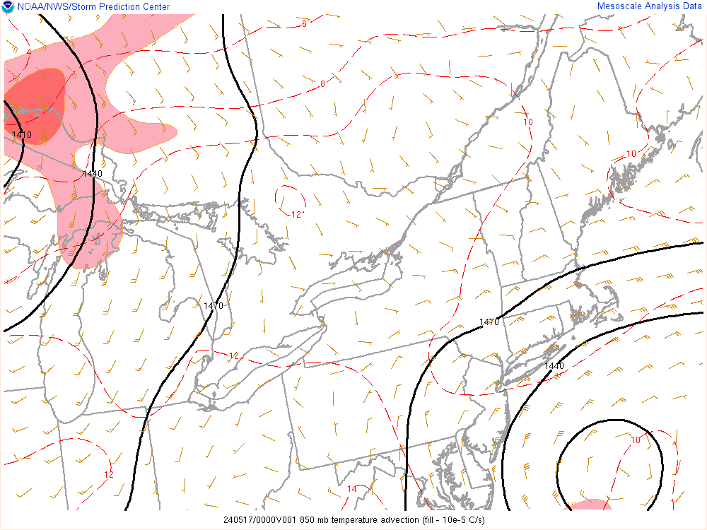
http://www.spc.noaa.gov/exper/mesoanalysis/s19/850mb/850mb_sf.gif?1422826421908
After comparing the 850 hPa forecast temperatures FOR 18z today (predictions for 3.5 hours ago) of the 12z GFS Op, the 12z EURO op, the 12z CMC Op, the 18z Hi-Res (4km) NAM, and the 18z RGEM, this is what I found (note, link are provided for your own analyses):
1). The GFS Op is way overdone with the warm air behind the system, and noticeably so ahead of it
http://www.earthsat.com/misc/mod-images/GFS/OP/12/GFS_12_opUS_T850C_0006.png
2). The CMC OP is way overdone with the warm air behind the system, and slightly so ahead of it
http://www.tropicaltidbits.com/analysis/models/gem/2015020112/gem_T850_us_2.png
3). The EURO Op is way overdone with the warm air behind the system, slightly so over IN but slightly underdone over OH.
http://www.earthsat.com/misc/mod-images/ECM/OP/12/ECM_12_opUS_T850C_0006.png
4). The 18z Hi-res (4km) NAM FOR THE CURRENT TIME is slightly too warm behind the system, perfect through IN, slightly too cold over OH but too warm over WV
http://www.tropicaltidbits.com/analysis/models/nam4km/2015020118/nam4km_T850_us_2.png
5. The 18z RGEM FOR THE CURRENT TIME is slightly too warm behind and ahead of the system, and noticeably too warm over WV.
http://www.tropicaltidbits.com/analysis/models/rgem/2015020118/rgem_T850_us_2.png
I don't know, nor necessarily think, that this will make any difference in the grand scheme of things as we head into the overnight, but those were my observations. Again, I provided the links so you can see for yourselves and draw your own conclusions INDEPENDENTLY of mine. My conclusions are that many of the models are in fact overdoing the advancement of the warm air at the 850 hPa level. This does not necessarily mean that colder solutions are likely to verify, as I did not analyze other levels (e.g. 925 hPa), and so warm air could still be filtering as projected beneath the 850 hPa level. Remember unless I specifically said "FOR THE CURRENT TIME", the comparison was done between the current time observations from the SPC Meso-analysis page (see link at the top of this post) and the forecasts from the 12z operational runs of the Global models for 18z today (1pm).
Please feel free to disagree, agree, question; that's why I posted this- to have discussions.
Last edited by rb924119 on Sun Feb 01, 2015 5:05 pm; edited 3 times in total
rb924119- Meteorologist

- Posts : 6889
Reputation : 194
Join date : 2013-02-06
Age : 32
Location : Greentown, Pa
Re: Updated Snow Map & Observations Thread, 2/1-2/2 Storm
![]() by NjWeatherGuy Sun Feb 01, 2015 4:55 pm
by NjWeatherGuy Sun Feb 01, 2015 4:55 pm

NjWeatherGuy- Advanced Forecaster

- Posts : 4100
Reputation : 28
Join date : 2013-01-06
Location : Belle Mead, NJ
Re: Updated Snow Map & Observations Thread, 2/1-2/2 Storm
![]() by Math23x7 Sun Feb 01, 2015 5:00 pm
by Math23x7 Sun Feb 01, 2015 5:00 pm
https://www.youtube.com/watch?v=O7ApxVyskuI
Math23x7- Wx Statistician Guru
- Posts : 2379
Reputation : 68
Join date : 2013-01-08
Re: Updated Snow Map & Observations Thread, 2/1-2/2 Storm
![]() by amugs Sun Feb 01, 2015 5:04 pm
by amugs Sun Feb 01, 2015 5:04 pm
snow247 wrote:jmanley32 wrote:Holy crap:
NORTHERN MIDDLESEX-NORTHERN NEW LONDON-SOUTHERN FAIRFIELD-
SOUTHERN NEW HAVEN-WESTERN PASSAIC-EASTERN PASSAIC-WESTERN BERGEN-
EASTERN BERGEN-WESTERN ESSEX-ROCKLAND-NORTHERN WESTCHESTER-
SOUTHERN WESTCHESTER-
401 PM EST SUN FEB 1 2015
...WINTER STORM WARNING REMAINS IN EFFECT FROM 7 PM THIS EVENING
TO 6 PM EST MONDAY...
* LOCATIONS...CENTRAL PORTIONS OF THE LOWER HUDSON VALLEY...
INTERIOR PORTIONS OF NORTHEASTERN NEW JERSEY...AND MUCH OF
SOUTHERN CONNECTICUT.
* HAZARD TYPES...HEAVY SNOW...SLEET...AND FREEZING RAIN.
* ACCUMULATIONS...SNOW ACCUMULATION OF 4 TO 9 INCHES...ALONG WITH
AROUND ONE QUARTER TO ONE HALF INCH OF ICE.
* TIMING...TONIGHT THROUGH MONDAY. HEAVY SNOW LATE TONIGHT INTO
MONDAY MORNING...CHANGING TO A MIXTURE OF SNOW...SLEET...AND
FREEZING RAIN...THEN CHANGING BACK TO SNOW IN THE AFTERNOON.
* TEMPERATURES...IN THE MID TO UPPER 20S.
* WINDS...EAST WINDS 10 TO 20 MPH WITH GUSTS UP TO 30 MPH IN THE
MORNING. NORTHWEST WINDS OF 15 TO 25 MPH WITH GUSTS UP TO 40 MPH
LATE MONDAY.
* VISIBILITIES...ONE QUARTER MILE OR LESS AT TIMES LATE TONIGHT
INTO EARLY MONDAY MORNING.
Looks like no school tomorrow for most.
They went from 6-12 inches down to 4-9 too.
LOCK IT UP SCHOOL CANCELLED PEEPS - they see this forecast and they shiver - ice ice baby.
Done with the globals at this point - onto Short Range Models $K HIR RES NAM


If this verifies HOLY CRAP we are in for a crippling storm up here in NNJ!!! Trend south or better yet put a call into Canada and realease teh butterflies!
_________________
Mugs
AKA:King: Snow Weenie
Self Proclaimed
WINTER 2014-15 : 55.12" +.02 for 6 coatings (avg. 35")
WINTER 2015-16 Total - 29.8" (Avg 35")
WINTER 2016-17 : 39.5" so far

amugs- Advanced Forecaster - Mod

- Posts : 15093
Reputation : 213
Join date : 2013-01-07
Age : 54
Location : Hillsdale,NJ
Re: Updated Snow Map & Observations Thread, 2/1-2/2 Storm
![]() by jmanley32 Sun Feb 01, 2015 5:05 pm
by jmanley32 Sun Feb 01, 2015 5:05 pm

jmanley32- Senior Enthusiast
- Posts : 20513
Reputation : 108
Join date : 2013-12-12
Age : 42
Location : Yonkers, NY
Re: Updated Snow Map & Observations Thread, 2/1-2/2 Storm
![]() by jmanley32 Sun Feb 01, 2015 5:08 pm
by jmanley32 Sun Feb 01, 2015 5:08 pm
jmanley32- Senior Enthusiast
- Posts : 20513
Reputation : 108
Join date : 2013-12-12
Age : 42
Location : Yonkers, NY
Re: Updated Snow Map & Observations Thread, 2/1-2/2 Storm
![]() by jmanley32 Sun Feb 01, 2015 5:13 pm
by jmanley32 Sun Feb 01, 2015 5:13 pm
jmanley32- Senior Enthusiast
- Posts : 20513
Reputation : 108
Join date : 2013-12-12
Age : 42
Location : Yonkers, NY
Re: Updated Snow Map & Observations Thread, 2/1-2/2 Storm
![]() by 2004blackwrx Sun Feb 01, 2015 5:13 pm
by 2004blackwrx Sun Feb 01, 2015 5:13 pm
 " />
" /> " />
" /> " />
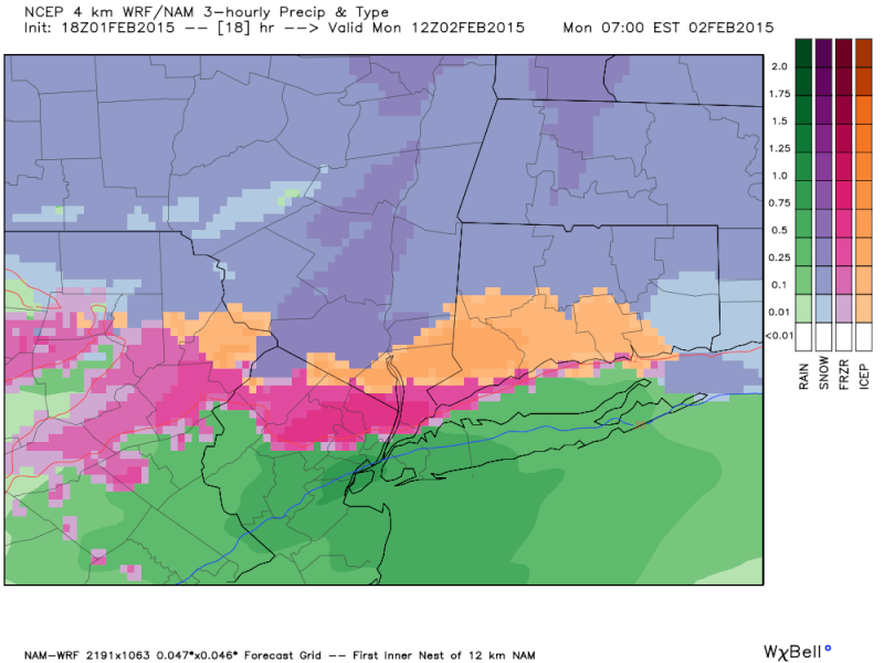
" />Based on the qpf forecasted and temps I could see a sweet spot for the snow set up around I-84.
2004blackwrx- Pro Enthusiast
- Posts : 576
Reputation : 9
Join date : 2013-01-14
Location : Wappinger NY
Re: Updated Snow Map & Observations Thread, 2/1-2/2 Storm
![]() by jmanley32 Sun Feb 01, 2015 5:17 pm
by jmanley32 Sun Feb 01, 2015 5:17 pm

jmanley32- Senior Enthusiast
- Posts : 20513
Reputation : 108
Join date : 2013-12-12
Age : 42
Location : Yonkers, NY
Re: Updated Snow Map & Observations Thread, 2/1-2/2 Storm
![]() by sroc4 Sun Feb 01, 2015 5:18 pm
by sroc4 Sun Feb 01, 2015 5:18 pm
_________________
"In weather and in life, there's no winning and losing; there's only winning and learning."
WINTER 2012/2013 TOTALS 43.65"WINTER 2017/2018 TOTALS 62.85" WINTER 2022/2023 TOTALS 4.9"
WINTER 2013/2014 TOTALS 64.85"WINTER 2018/2019 TOTALS 14.25" WINTER 2023/2024 TOTALS 13.1"
WINTER 2014/2015 TOTALS 71.20"WINTER 2019/2020 TOTALS 6.35"
WINTER 2015/2016 TOTALS 35.00"WINTER 2020/2021 TOTALS 37.75"
WINTER 2016/2017 TOTALS 42.25"WINTER 2021/2022 TOTALS 31.65"

sroc4- Admin

- Posts : 8331
Reputation : 301
Join date : 2013-01-07
Location : Wading River, LI
Re: Updated Snow Map & Observations Thread, 2/1-2/2 Storm
![]() by rb924119 Sun Feb 01, 2015 5:19 pm
by rb924119 Sun Feb 01, 2015 5:19 pm
rb924119- Meteorologist
- Posts : 6889
Reputation : 194
Join date : 2013-02-06
Age : 32
Location : Greentown, Pa
Re: Updated Snow Map & Observations Thread, 2/1-2/2 Storm
![]() by jmanley32 Sun Feb 01, 2015 5:20 pm
by jmanley32 Sun Feb 01, 2015 5:20 pm
jmanley32- Senior Enthusiast
- Posts : 20513
Reputation : 108
Join date : 2013-12-12
Age : 42
Location : Yonkers, NY
Re: Updated Snow Map & Observations Thread, 2/1-2/2 Storm
![]() by sroc4 Sun Feb 01, 2015 5:22 pm
by sroc4 Sun Feb 01, 2015 5:22 pm
rb924119 wrote:Pic isn't showing up, Sroc.
How bout now?
_________________
"In weather and in life, there's no winning and losing; there's only winning and learning."
WINTER 2012/2013 TOTALS 43.65"WINTER 2017/2018 TOTALS 62.85" WINTER 2022/2023 TOTALS 4.9"
WINTER 2013/2014 TOTALS 64.85"WINTER 2018/2019 TOTALS 14.25" WINTER 2023/2024 TOTALS 13.1"
WINTER 2014/2015 TOTALS 71.20"WINTER 2019/2020 TOTALS 6.35"
WINTER 2015/2016 TOTALS 35.00"WINTER 2020/2021 TOTALS 37.75"
WINTER 2016/2017 TOTALS 42.25"WINTER 2021/2022 TOTALS 31.65"
sroc4- Admin
- Posts : 8331
Reputation : 301
Join date : 2013-01-07
Location : Wading River, LI
Re: Updated Snow Map & Observations Thread, 2/1-2/2 Storm
![]() by rb924119 Sun Feb 01, 2015 5:23 pm
by rb924119 Sun Feb 01, 2015 5:23 pm
jmanley32 wrote:it is here try refresh rb.
Got it lol
rb924119- Meteorologist
- Posts : 6889
Reputation : 194
Join date : 2013-02-06
Age : 32
Location : Greentown, Pa
Re: Updated Snow Map & Observations Thread, 2/1-2/2 Storm
![]() by NjWeatherGuy Sun Feb 01, 2015 5:26 pm
by NjWeatherGuy Sun Feb 01, 2015 5:26 pm
NjWeatherGuy- Advanced Forecaster
- Posts : 4100
Reputation : 28
Join date : 2013-01-06
Location : Belle Mead, NJ
Re: Updated Snow Map & Observations Thread, 2/1-2/2 Storm
![]() by sroc4 Sun Feb 01, 2015 5:26 pm
by sroc4 Sun Feb 01, 2015 5:26 pm
http://earth.nullschool.net/#current/wind/isobaric/500hPa/orthographic=-87.89,47.58,1024
_________________
"In weather and in life, there's no winning and losing; there's only winning and learning."
WINTER 2012/2013 TOTALS 43.65"WINTER 2017/2018 TOTALS 62.85" WINTER 2022/2023 TOTALS 4.9"
WINTER 2013/2014 TOTALS 64.85"WINTER 2018/2019 TOTALS 14.25" WINTER 2023/2024 TOTALS 13.1"
WINTER 2014/2015 TOTALS 71.20"WINTER 2019/2020 TOTALS 6.35"
WINTER 2015/2016 TOTALS 35.00"WINTER 2020/2021 TOTALS 37.75"
WINTER 2016/2017 TOTALS 42.25"WINTER 2021/2022 TOTALS 31.65"
sroc4- Admin
- Posts : 8331
Reputation : 301
Join date : 2013-01-07
Location : Wading River, LI
Re: Updated Snow Map & Observations Thread, 2/1-2/2 Storm
![]() by snow247 Sun Feb 01, 2015 5:47 pm
by snow247 Sun Feb 01, 2015 5:47 pm
snow247- Pro Enthusiast
- Posts : 2417
Reputation : 0
Join date : 2014-08-27
Location : Mount Ivy, NY - Elevation 545'
Re: Updated Snow Map & Observations Thread, 2/1-2/2 Storm
![]() by Frank_Wx Sun Feb 01, 2015 5:52 pm
by Frank_Wx Sun Feb 01, 2015 5:52 pm
_________________
_______________________________________________________________________________________________________
CLICK HERE to view NJ Strong Snowstorm Classifications

Frank_Wx- Godzilla Seeker
- Posts : 21305
Reputation : 328
Join date : 2013-01-05
Age : 31
Location : Jersey City, NJ -

Re: Updated Snow Map & Observations Thread, 2/1-2/2 Storm
![]() by weatherwatchermom Sun Feb 01, 2015 5:56 pm
by weatherwatchermom Sun Feb 01, 2015 5:56 pm
Frank_Wx wrote:The first WAA is not as impressive as the second one expected to come overnight
does that mean we are going to start out cooler than expected for now...its raw out right now...got that feel of snow in the air...or is that my imagination??

weatherwatchermom- Senior Enthusiast
- Posts : 3734
Reputation : 77
Join date : 2014-11-25
Age : 60
Location : Hazlet Township, NJ
Re: Updated Snow Map & Observations Thread, 2/1-2/2 Storm
![]() by SNOW MAN Sun Feb 01, 2015 5:57 pm
by SNOW MAN Sun Feb 01, 2015 5:57 pm

SNOW MAN- Senior Enthusiast
- Posts : 1361
Reputation : 25
Join date : 2013-01-13
Age : 64
Location : Marshalls Creek Pa.
Re: Updated Snow Map & Observations Thread, 2/1-2/2 Storm
![]() by Taffy Sun Feb 01, 2015 6:06 pm
by Taffy Sun Feb 01, 2015 6:06 pm

Taffy- Pro Enthusiast
- Posts : 530
Reputation : 19
Join date : 2013-10-06
Location : Hopkinton, MA
Re: Updated Snow Map & Observations Thread, 2/1-2/2 Storm
![]() by Guest Sun Feb 01, 2015 6:13 pm
by Guest Sun Feb 01, 2015 6:13 pm
Guest- Guest
Re: Updated Snow Map & Observations Thread, 2/1-2/2 Storm
![]() by SNOW MAN Sun Feb 01, 2015 6:17 pm
by SNOW MAN Sun Feb 01, 2015 6:17 pm
Taffy wrote:Snow man, I'm 70 miles from you so my nose will be plastered to the window like a puppy. I can't wait for this to begin. I want to see what happens for real!
I know just what you mean. Once it starts snowing just can't help but keep looking outside at it. It's just a beautiful site.
SNOW MAN- Senior Enthusiast
- Posts : 1361
Reputation : 25
Join date : 2013-01-13
Age : 64
Location : Marshalls Creek Pa.
Page 3 of 30 • 1, 2, 3, 4 ... 16 ... 30 ![]()
|
|
|