
 Search
Updated Final Call Snow Map, Observations Thread 2/21-2/22
Page 1 of 29 • 1, 2, 3 ... 15 ... 29 ![]()

Updated Final Call Snow Map, Observations Thread 2/21-2/22
![]() by Frank_Wx Sat Feb 21, 2015 7:24 am
by Frank_Wx Sat Feb 21, 2015 7:24 am

I went colder for the majority of the area and shifted the jackpot zone further south and east. Precipitation is moving in at a rapid rate this morning which means the more cold air we have to work with and less warm air we have to deal with (since there will not be as much precip. left to fall). Additionally, guidance is keying in on shifting the baroclinic zone further south and east as well. Areas just north or west of this zone will experience the greatest frontogenesis. Snowfall rates will be in the order of 1"-2" an hour. I do expect a changeover to ice and rain around NYC Metro still, but like I said, the amounts of precip that will be left probably won't be a lot. Coastal NJ and SNJ can expect a little more rain, hence the lower amounts.
**Isolated areas near the red jackpot zone that are in blue could see amounts greater than 6" as well.**
Should be an interesting storm to nowcast.
It looks healthy
http://www.intellicast.com/Local/WxMap.aspx
Last edited by Frank_Wx on Sat Feb 21, 2015 7:31 am; edited 1 time in total
_________________
_______________________________________________________________________________________________________
CLICK HERE to view NJ Strong Snowstorm Classifications

Frank_Wx- Godzilla Seeker

- Posts : 21305
Reputation : 328
Join date : 2013-01-05
Age : 31
Location : Jersey City, NJ -

Re: Updated Final Call Snow Map, Observations Thread 2/21-2/22
![]() by mmanisca Sat Feb 21, 2015 7:29 am
by mmanisca Sat Feb 21, 2015 7:29 am

mmanisca- Pro Enthusiast

- Posts : 298
Reputation : 3
Join date : 2013-01-23
Age : 65
Location : Deer Park, Long Island
Re: Updated Final Call Snow Map, Observations Thread 2/21-2/22
![]() by sroc4 Sat Feb 21, 2015 7:31 am
by sroc4 Sat Feb 21, 2015 7:31 am
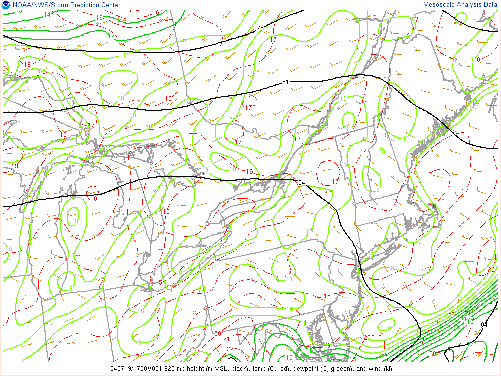
The latest model trends have a contiguous system which crosses middle Appalachia into PA and NJ. I account for snow cover, depth of cold air, and the fact that, for all of the warm air advecting north along the backside of the surface high, the push of warmer air gets subverted by the surge of Arctic values. Remember that cold air always wins out over warmth when a westerly component is noted with 500MB winds. So I see a changeover scenario whereas others may only be looking at rain.
So if you look at the current mesoscale analysis at 850mb you can see the flood gates are open for business to the GOM; the blue indicates the freezing line:
http://earth.nullschool.net/#current/wind/isobaric/850hPa/overlay=temp/orthographic=-87.32,35.91,2048
But as the comment states above 500mb is westerly:
http://earth.nullschool.net/#current/wind/isobaric/500hPa/overlay=temp/orthographic=-82.69,37.64,2048
The point here is that it is going to be a positive now cast for many on this board...I think...esp for my friends N and W.
_________________
"In weather and in life, there's no winning and losing; there's only winning and learning."
WINTER 2012/2013 TOTALS 43.65"WINTER 2017/2018 TOTALS 62.85" WINTER 2022/2023 TOTALS 4.9"
WINTER 2013/2014 TOTALS 64.85"WINTER 2018/2019 TOTALS 14.25" WINTER 2023/2024 TOTALS 13.1"
WINTER 2014/2015 TOTALS 71.20"WINTER 2019/2020 TOTALS 6.35"
WINTER 2015/2016 TOTALS 35.00"WINTER 2020/2021 TOTALS 37.75"
WINTER 2016/2017 TOTALS 42.25"WINTER 2021/2022 TOTALS 31.65"

sroc4- Admin
- Posts : 8331
Reputation : 301
Join date : 2013-01-07
Location : Wading River, LI
Re: Updated Final Call Snow Map, Observations Thread 2/21-2/22
![]() by Frank_Wx Sat Feb 21, 2015 7:34 am
by Frank_Wx Sat Feb 21, 2015 7:34 am
_________________
_______________________________________________________________________________________________________
CLICK HERE to view NJ Strong Snowstorm Classifications
Frank_Wx- Godzilla Seeker
- Posts : 21305
Reputation : 328
Join date : 2013-01-05
Age : 31
Location : Jersey City, NJ -
Re: Updated Final Call Snow Map, Observations Thread 2/21-2/22
![]() by Frank_Wx Sat Feb 21, 2015 7:35 am
by Frank_Wx Sat Feb 21, 2015 7:35 am
sroc4 wrote:This comment was made on the 18th by Larry Cosgrove. This was when the LP was a strong GLC soln:
The latest model trends have a contiguous system which crosses middle Appalachia into PA and NJ. I account for snow cover, depth of cold air, and the fact that, for all of the warm air advecting north along the backside of the surface high, the push of warmer air gets subverted by the surge of Arctic values. Remember that cold air always wins out over warmth when a westerly component is noted with 500MB winds. So I see a changeover scenario whereas others may only be looking at rain.
So if you look at the current mesoscale analysis at 850mb you can see the flood gates are open for business to the GOM; the blue indicates the freezing line:
http://earth.nullschool.net/#current/wind/isobaric/850hPa/overlay=temp/orthographic=-87.32,35.91,2048
But as the comment states above 500mb is westerly:
http://earth.nullschool.net/#current/wind/isobaric/500hPa/overlay=temp/orthographic=-82.69,37.64,2048
The point here is that it is going to be a positive now cast for many on this board...I think...esp for my friends N and W.
An excellent post. By you and LC.
_________________
_______________________________________________________________________________________________________
CLICK HERE to view NJ Strong Snowstorm Classifications
Frank_Wx- Godzilla Seeker
- Posts : 21305
Reputation : 328
Join date : 2013-01-05
Age : 31
Location : Jersey City, NJ -
Re: Updated Final Call Snow Map, Observations Thread 2/21-2/22
![]() by Frank_Wx Sat Feb 21, 2015 7:52 am
by Frank_Wx Sat Feb 21, 2015 7:52 am

_________________
_______________________________________________________________________________________________________
CLICK HERE to view NJ Strong Snowstorm Classifications
Frank_Wx- Godzilla Seeker
- Posts : 21305
Reputation : 328
Join date : 2013-01-05
Age : 31
Location : Jersey City, NJ -
Re: Updated Final Call Snow Map, Observations Thread 2/21-2/22
![]() by lglickman1 Sat Feb 21, 2015 7:55 am
by lglickman1 Sat Feb 21, 2015 7:55 am
lglickman1- Pro Enthusiast
- Posts : 319
Reputation : 0
Join date : 2013-02-05
Location : New Rochelle, NY
Re: Updated Final Call Snow Map, Observations Thread 2/21-2/22
![]() by Dunnzoo Sat Feb 21, 2015 7:57 am
by Dunnzoo Sat Feb 21, 2015 7:57 am
_________________
Janet
Snowfall winter of 2023-2024 17.5"
Snowfall winter of 2022-2023 6.0"
Snowfall winter of 2021-2022 17.6" 1" sleet 2/25/22
Snowfall winter of 2020-2021 51.1"
Snowfall winter of 2019-2020 8.5"
Snowfall winter of 2018-2019 25.1"
Snowfall winter of 2017-2018 51.9"
Snowfall winter of 2016-2017 45.6"
Snowfall winter of 2015-2016 29.5"
Snowfall winter of 2014-2015 50.55"
Snowfall winter of 2013-2014 66.5"

Dunnzoo- Senior Enthusiast - Mod

- Posts : 4889
Reputation : 68
Join date : 2013-01-11
Age : 62
Location : Westwood, NJ
Re: Updated Final Call Snow Map, Observations Thread 2/21-2/22
![]() by Frank_Wx Sat Feb 21, 2015 8:00 am
by Frank_Wx Sat Feb 21, 2015 8:00 am
_________________
_______________________________________________________________________________________________________
CLICK HERE to view NJ Strong Snowstorm Classifications
Frank_Wx- Godzilla Seeker
- Posts : 21305
Reputation : 328
Join date : 2013-01-05
Age : 31
Location : Jersey City, NJ -
Re: Updated Final Call Snow Map, Observations Thread 2/21-2/22
![]() by HeresL Sat Feb 21, 2015 8:04 am
by HeresL Sat Feb 21, 2015 8:04 am
lglickman1 wrote:Did something change overnight that made upton change their snow amounts?
I'm confused as well. Upton had me in 6-8 last night but down to 4-6 this morning...
HeresL- Posts : 122
Reputation : 0
Join date : 2013-01-20
Location : West Milford, NJ
Re: Updated Final Call Snow Map, Observations Thread 2/21-2/22
![]() by Quietace Sat Feb 21, 2015 8:08 am
by Quietace Sat Feb 21, 2015 8:08 am

Quietace- Meteorologist - Mod

- Posts : 3687
Reputation : 33
Join date : 2013-01-07
Age : 27
Location : Point Pleasant, NJ
Re: Updated Final Call Snow Map, Observations Thread 2/21-2/22
![]() by algae888 Sat Feb 21, 2015 8:14 am
by algae888 Sat Feb 21, 2015 8:14 am

algae888- Advanced Forecaster

- Posts : 5311
Reputation : 46
Join date : 2013-02-05
Age : 61
Location : mt. vernon, new york
Re: Updated Final Call Snow Map, Observations Thread 2/21-2/22
![]() by algae888 Sat Feb 21, 2015 8:16 am
by algae888 Sat Feb 21, 2015 8:16 am
algae888- Advanced Forecaster
- Posts : 5311
Reputation : 46
Join date : 2013-02-05
Age : 61
Location : mt. vernon, new york
Re: Updated Final Call Snow Map, Observations Thread 2/21-2/22
![]() by Quietace Sat Feb 21, 2015 8:16 am
by Quietace Sat Feb 21, 2015 8:16 am
Quietace- Meteorologist - Mod
- Posts : 3687
Reputation : 33
Join date : 2013-01-07
Age : 27
Location : Point Pleasant, NJ
Re: Updated Final Call Snow Map, Observations Thread 2/21-2/22
![]() by snow247 Sat Feb 21, 2015 8:22 am
by snow247 Sat Feb 21, 2015 8:22 am

snow247- Pro Enthusiast
- Posts : 2417
Reputation : 0
Join date : 2014-08-27
Location : Mount Ivy, NY - Elevation 545'
Re: Updated Final Call Snow Map, Observations Thread 2/21-2/22
![]() by oldtimer Sat Feb 21, 2015 8:24 am
by oldtimer Sat Feb 21, 2015 8:24 am
oldtimer- Senior Enthusiast

- Posts : 1103
Reputation : 14
Join date : 2013-01-16
Age : 78
Location : Port Jefferson Station Suffolk County
Re: Updated Final Call Snow Map, Observations Thread 2/21-2/22
![]() by algae888 Sat Feb 21, 2015 8:27 am
by algae888 Sat Feb 21, 2015 8:27 am
algae888- Advanced Forecaster
- Posts : 5311
Reputation : 46
Join date : 2013-02-05
Age : 61
Location : mt. vernon, new york
Re: Updated Final Call Snow Map, Observations Thread 2/21-2/22
![]() by Quietace Sat Feb 21, 2015 8:28 am
by Quietace Sat Feb 21, 2015 8:28 am

Quietace- Meteorologist - Mod
- Posts : 3687
Reputation : 33
Join date : 2013-01-07
Age : 27
Location : Point Pleasant, NJ
Re: Updated Final Call Snow Map, Observations Thread 2/21-2/22
![]() by Frank_Wx Sat Feb 21, 2015 8:31 am
by Frank_Wx Sat Feb 21, 2015 8:31 am

_________________
_______________________________________________________________________________________________________
CLICK HERE to view NJ Strong Snowstorm Classifications
Frank_Wx- Godzilla Seeker
- Posts : 21305
Reputation : 328
Join date : 2013-01-05
Age : 31
Location : Jersey City, NJ -
Re: Updated Final Call Snow Map, Observations Thread 2/21-2/22
![]() by skinsfan1177 Sat Feb 21, 2015 8:34 am
by skinsfan1177 Sat Feb 21, 2015 8:34 am

skinsfan1177- Senior Enthusiast
- Posts : 4485
Reputation : 35
Join date : 2013-01-07
Age : 46
Location : Point Pleasant Boro
Re: Updated Final Call Snow Map, Observations Thread 2/21-2/22
![]() by rb924119 Sat Feb 21, 2015 8:35 am
by rb924119 Sat Feb 21, 2015 8:35 am
rb924119- Meteorologist

- Posts : 6889
Reputation : 194
Join date : 2013-02-06
Age : 32
Location : Greentown, Pa
Re: Updated Final Call Snow Map, Observations Thread 2/21-2/22
![]() by docstox12 Sat Feb 21, 2015 8:38 am
by docstox12 Sat Feb 21, 2015 8:38 am

docstox12- Wx Statistician Guru

- Posts : 8504
Reputation : 222
Join date : 2013-01-07
Age : 73
Location : Monroe NY
Re: Updated Final Call Snow Map, Observations Thread 2/21-2/22
![]() by mancave25 Sat Feb 21, 2015 8:48 am
by mancave25 Sat Feb 21, 2015 8:48 am
mancave25- Posts : 112
Reputation : 0
Join date : 2014-02-05
Re: Updated Final Call Snow Map, Observations Thread 2/21-2/22
![]() by snow247 Sat Feb 21, 2015 8:49 am
by snow247 Sat Feb 21, 2015 8:49 am
snow247- Pro Enthusiast
- Posts : 2417
Reputation : 0
Join date : 2014-08-27
Location : Mount Ivy, NY - Elevation 545'
Re: Updated Final Call Snow Map, Observations Thread 2/21-2/22
![]() by algae888 Sat Feb 21, 2015 8:51 am
by algae888 Sat Feb 21, 2015 8:51 am

6z

00z
Last edited by algae888 on Sat Feb 21, 2015 8:54 am; edited 1 time in total
algae888- Advanced Forecaster
- Posts : 5311
Reputation : 46
Join date : 2013-02-05
Age : 61
Location : mt. vernon, new york
Sponsored content
Page 1 of 29 • 1, 2, 3 ... 15 ... 29 ![]()
|
|
|