
 Search
Sunday-Monday Snowstorm - 2nd Call Snow Map
Page 4 of 8 •  1, 2, 3, 4, 5, 6, 7, 8
 ![]()
Re: Sunday-Monday Snowstorm - 2nd Call Snow Map
![]() by RJB8525 Sat Feb 28, 2015 6:04 pm
by RJB8525 Sat Feb 28, 2015 6:04 pm
RJB8525- Senior Enthusiast

- Posts : 1994
Join date : 2013-02-06
Re: Sunday-Monday Snowstorm - 2nd Call Snow Map
![]() by rb924119 Sat Feb 28, 2015 6:12 pm
by rb924119 Sat Feb 28, 2015 6:12 pm
Frank_Wx wrote:rb924119 wrote:Frank_Wx wrote:I just think this is a classic event with a strong upper level jet streak wedged between the PV and SE Ridge. That's where all your forcing is coming from.
But we aren't located in favorable spots for that to aid us; in fact, it's kind of the opposite or a non-factor completely.
Yes...ideally we want it south of us? Either way, the intense thermal gradients should help bring about frontogenesis.
Yeah. In the H2 image you posted, there would be three ideal locations and orientations. In the orientation that it is in on your image, we'd ideally want it located over extreme southern Ohio, Indiana and Illinois. Our second option, would be to have it oriented southwest-northeast from approximately 200 miles east of the Delmarva and stretching back to the south-southwest. Our third, and most likely only viable option if we had a coupled jet system with a second jet located where I just mentioned to stave off p-type issues) would to have it located in any orientation from around or just north of the eastern Great Lakes and stretching eastward from there.
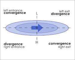
Take a look at the following images and see if you can figure it out. I don't mean to sound rude, but I have to go for a while. I'll be back to further explain in a little bit. This is the ageostrophic circulation that I was talking about in the case study. and why you tend to see rising/sinking motion associated with different locations in jets.
Idealized jet structure:
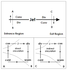
Cross-sections representing vertical motion associated with jets. The shorter and stronger the jet streak, the stronger the vertical circulations are (because of the dynamics, which I can explain later if you'd like; let me know):
rb924119- Meteorologist

- Posts : 6889
Join date : 2013-02-06
Re: Sunday-Monday Snowstorm - 2nd Call Snow Map
![]() by Mathgod55 Sat Feb 28, 2015 6:19 pm
by Mathgod55 Sat Feb 28, 2015 6:19 pm

Mathgod55- Posts : 60
Reputation : 0
Join date : 2013-01-08
Location : West Islip, NyY
Re: Sunday-Monday Snowstorm - 2nd Call Snow Map
![]() by Frank_Wx Sat Feb 28, 2015 6:20 pm
by Frank_Wx Sat Feb 28, 2015 6:20 pm
oldtimer wrote:Frank 7eyewitness hasn't changed anything since 7am this morning
Well, I can't see myself cutting back that much for the area so I guess we'll have to disagree.
_________________
_______________________________________________________________________________________________________
CLICK HERE to view NJ Strong Snowstorm Classifications

Frank_Wx- Godzilla Seeker

- Posts : 21305
Reputation : 328
Join date : 2013-01-05
Age : 31
Location : Jersey City, NJ -

Re: Sunday-Monday Snowstorm - 2nd Call Snow Map
![]() by Frank_Wx Sat Feb 28, 2015 6:27 pm
by Frank_Wx Sat Feb 28, 2015 6:27 pm
rb924119 wrote:Frank_Wx wrote:rb924119 wrote:Frank_Wx wrote:I just think this is a classic event with a strong upper level jet streak wedged between the PV and SE Ridge. That's where all your forcing is coming from.
But we aren't located in favorable spots for that to aid us; in fact, it's kind of the opposite or a non-factor completely.
Yes...ideally we want it south of us? Either way, the intense thermal gradients should help bring about frontogenesis.
Yeah. In the H2 image you posted, there would be three ideal locations and orientations. In the orientation that it is in on your image, we'd ideally want it located over extreme southern Ohio, Indiana and Illinois. Our second option, would be to have it oriented southwest-northeast from approximately 200 miles east of the Delmarva and stretching back to the south-southwest. Our third, and most likely only viable option if we had a coupled jet system with a second jet located where I just mentioned to stave off p-type issues) would to have it located in any orientation from around or just north of the eastern Great Lakes and stretching eastward from there.
Take a look at the following images and see if you can figure it out. I don't mean to sound rude, but I have to go for a while. I'll be back to further explain in a little bit. This is the ageostrophic circulation that I was talking about in the case study. and why you tend to see rising/sinking motion associated with different locations in jets.
Idealized jet structure:
Cross-sections representing vertical motion associated with jets. The shorter and stronger the jet streak, the stronger the vertical circulations are (because of the dynamics, which I can explain later if you'd like; let me know):
Will drinking wine help me understand this?
Haha, this was helpful. Thanks
_________________
_______________________________________________________________________________________________________
CLICK HERE to view NJ Strong Snowstorm Classifications
Frank_Wx- Godzilla Seeker
- Posts : 21305
Reputation : 328
Join date : 2013-01-05
Age : 31
Location : Jersey City, NJ -
Re: Sunday-Monday Snowstorm - 2nd Call Snow Map
![]() by CPcantmeasuresnow Sat Feb 28, 2015 6:27 pm
by CPcantmeasuresnow Sat Feb 28, 2015 6:27 pm
snow247 wrote:aiannone wrote:18z RGEM Close-up
What's with the screw zone in the mid-upper HV?
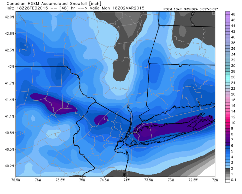
Hey Doc prepare to get scrooed by this thing. That dry area is only about 30 miles north of us on this run. Looks like it's aimed straight for us.

CPcantmeasuresnow- Wx Statistician Guru

- Posts : 7274
Reputation : 230
Join date : 2013-01-07
Age : 103
Location : Eastern Orange County, NY
Re: Sunday-Monday Snowstorm - 2nd Call Snow Map
![]() by skinsfan1177 Sat Feb 28, 2015 6:29 pm
by skinsfan1177 Sat Feb 28, 2015 6:29 pm

skinsfan1177- Senior Enthusiast
- Posts : 4485
Reputation : 35
Join date : 2013-01-07
Age : 46
Location : Point Pleasant Boro
Re: Sunday-Monday Snowstorm - 2nd Call Snow Map
![]() by jimv45 Sat Feb 28, 2015 6:33 pm
by jimv45 Sat Feb 28, 2015 6:33 pm
jimv45- Senior Enthusiast
- Posts : 1168
Reputation : 36
Join date : 2013-09-20
Location : Hopewell jct.
Re: Sunday-Monday Snowstorm - 2nd Call Snow Map
![]() by Frank_Wx Sat Feb 28, 2015 7:23 pm
by Frank_Wx Sat Feb 28, 2015 7:23 pm
I will not be here tonight. Hopefully 00z runs hold serve.
_________________
_______________________________________________________________________________________________________
CLICK HERE to view NJ Strong Snowstorm Classifications
Frank_Wx- Godzilla Seeker
- Posts : 21305
Reputation : 328
Join date : 2013-01-05
Age : 31
Location : Jersey City, NJ -
Re: Sunday-Monday Snowstorm - 2nd Call Snow Map
![]() by docstox12 Sat Feb 28, 2015 7:28 pm
by docstox12 Sat Feb 28, 2015 7:28 pm
CPcantmeasuresnow wrote:snow247 wrote:aiannone wrote:18z RGEM Close-up
What's with the screw zone in the mid-upper HV?
Hey Doc prepare to get scrooed by this thing. That dry area is only about 30 miles north of us on this run. Looks like it's aimed straight for us.
CP, with the dry slots, south shifts, Hudson River Force Fields, sinking dry air ,subsidence thingys happening to us all winter, I am truly amazed we are pushing 60 inches up here,LOL! Just looking for 3 to top off over 60 and I'll be happy with the season.Anything after that in March is bonus.

docstox12- Wx Statistician Guru
- Posts : 8502
Reputation : 222
Join date : 2013-01-07
Age : 73
Location : Monroe NY
Re: Sunday-Monday Snowstorm - 2nd Call Snow Map
![]() by rb924119 Sat Feb 28, 2015 7:33 pm
by rb924119 Sat Feb 28, 2015 7:33 pm
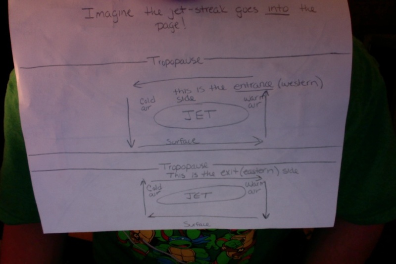
The first image should be pretty self-explanatory. All it is showing is a view of an idealized jet-streak (just like the one Frank posted on the last page at H2), divided into four parts. These are labeled such that you are flying along in the jet itself (hence, as you enter the jets western side, to your left is the left-entrance region and to your right is the right-entrance region). Now, as the wind (geostrophic/regular wind we think of when looking at this level) comes into the western side of the jet-streak, it experiences a relatively large net change in speed (acceleration.......that's why it is called a jet-STREAK) over a relatively short distance. However, the atmosphere does not like these changes because of the force balances that it is governed by, and so tries to maintain these balances by the only way it knows how: Vertical motion. How does it do this? Well, if the actual wind is being accelerated by the jet-streak which then takes it out of balance, then the only way that the atmosphere can slow it down and bring it back into balance is to slow it down. To do this, the atmosphere "generates" a secondary "wind" called the ageostrophic "wind" that opposes the acceleration of the regular wind by "blowing" in the opposite direction (think of walking into a head-wind....a lot harder than going with a tail-wind, right?). However, as this "wind" is "blowing" against the regular wind, as it does so, it is "moving" across generally large horizontal distances; large enough that it becomes influenced by the Coriolis force, which acts to deflect things to the right in the Northern Hemisphere.
So now picture this "wind" moving against the regular wind but also being deflected to the right as it does so. Also picture that this wind decreases to nothing (ideally) as you move further away from the jet-streak in any direction. If you can do these two things, you will see that the ageostrophic "wind" converges in the left entrance region of the jet-streak (again, think of yourself flying into the western side of it). Because of this convergence, and assuming that the Tropopause (which is not too far above this level) is an impermeable layer....if the winds are converging here, then THEY MUST CONVERGE AND SINK. This causes large-scale subsidence in the left entrance region of a jet (in the Northern Hemisphere). If air is sinking, air also has to rise (conservation of mass). Remember how the ageostrophic "wind" "blows" against the normal wind and is then deflected to the right??? This leaves an area of divergence in the right entrance region....if air is spreading out here, then it must be getting replaced by air below it: large-scale ASCENT!!! Now, the last thing I want you to try and picture (refer to my second image) is taking a slice across the jet in these areas. If you can do this, you will find that the warm air (in the right entrance region) is rising and the cold air (in the left entrance region) is sinking. This is known as a thermally direct circulation.
For the exit regions (eastern side of the jet-streak, left and right, again with respect to you flying in the jet), these processes are reversed. Instead of the regular wind speeding up, it is now slowing down as it exits the jet-STREAK, and again, the atmosphere does not like this because it is being thrown out of balance. So, again, here comes the ageostrophic "wind", which still opposes the net change in speed of the regular wind (which is deceleration here). However, this time, that means it is "blowing" WITH the normal wind (think of walking with a tail-wind now, and it is trying to "bring the regular wind back up to speed", so to speak). The Coriolis is still able to act on it, so it is again deflected to the right. Since the ageostrophic "wind" still decreases to nothing the further away from the jet-streak you look, you end up with a circulation such that the right-exit region sees the convergence and the left-exit region sees the divergence (again assuming the Troposphere is impermeable). Where there is convergence of this "wind", there is again large-scale sinking motion, and where there is divergence, there is large-scale ascent. Looking at another cross-section (again, refer image two), you will find that cold air in the left-exit region is now being forced to rise, while the warm air is being forced to sink. This is called a thermally indirect circulation. Basically, this causes two opposing cross-jet circulations on the western and eastern halves of the jet, respectively, which are what are referenced when "jet dynamics" are mentioned in discussions.
I know this is long, but I hope it helps lol
rb924119- Meteorologist
- Posts : 6889
Reputation : 194
Join date : 2013-02-06
Age : 32
Location : Greentown, Pa
Re: Sunday-Monday Snowstorm - 2nd Call Snow Map
![]() by docstox12 Sat Feb 28, 2015 7:45 pm
by docstox12 Sat Feb 28, 2015 7:45 pm
Frank, I'd need a bottle of wine to even try to get the whole picture here, but you guys truly amaze me with your knowledge.
docstox12- Wx Statistician Guru
- Posts : 8502
Reputation : 222
Join date : 2013-01-07
Age : 73
Location : Monroe NY
Re: Sunday-Monday Snowstorm - 2nd Call Snow Map
![]() by rb924119 Sat Feb 28, 2015 7:46 pm
by rb924119 Sat Feb 28, 2015 7:46 pm
rb924119- Meteorologist
- Posts : 6889
Reputation : 194
Join date : 2013-02-06
Age : 32
Location : Greentown, Pa
Re: Sunday-Monday Snowstorm - 2nd Call Snow Map
![]() by Math23x7 Sat Feb 28, 2015 7:46 pm
by Math23x7 Sat Feb 28, 2015 7:46 pm
Math23x7- Wx Statistician Guru
- Posts : 2379
Reputation : 68
Join date : 2013-01-08
Re: Sunday-Monday Snowstorm - 2nd Call Snow Map
![]() by docstox12 Sat Feb 28, 2015 7:49 pm
by docstox12 Sat Feb 28, 2015 7:49 pm
docstox12- Wx Statistician Guru
- Posts : 8502
Reputation : 222
Join date : 2013-01-07
Age : 73
Location : Monroe NY
Re: Sunday-Monday Snowstorm - 2nd Call Snow Map
![]() by rb924119 Sat Feb 28, 2015 7:52 pm
by rb924119 Sat Feb 28, 2015 7:52 pm
rb924119- Meteorologist
- Posts : 6889
Reputation : 194
Join date : 2013-02-06
Age : 32
Location : Greentown, Pa
Re: Sunday-Monday Snowstorm - 2nd Call Snow Map
![]() by rb924119 Sat Feb 28, 2015 8:56 pm
by rb924119 Sat Feb 28, 2015 8:56 pm
docstox12 wrote:Wow, rb, this is awesome.Now I can see a bit how these wind patterns can cause the phenomena of dry slots.I'd have to really read this three or four times more, but I think I catch what you mean.
Frank, I'd need a bottle of wine to even try to get the whole picture here, but you guys truly amaze me with your knowledge.
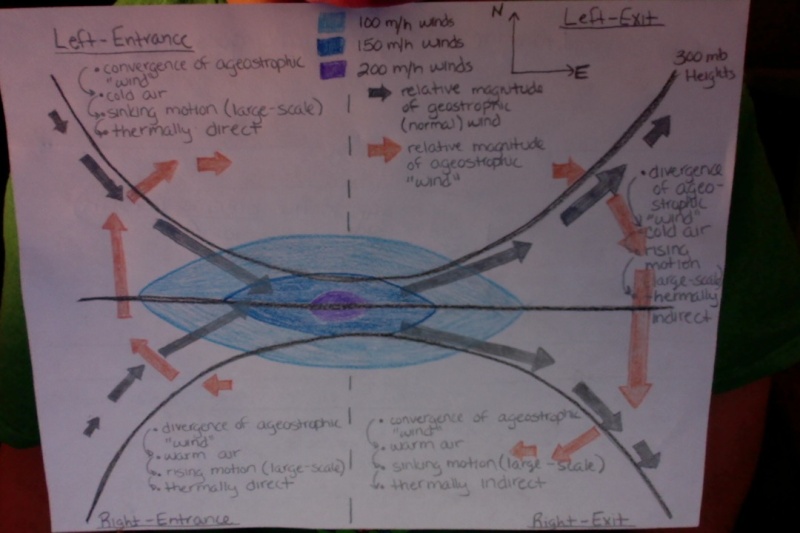
Here Doc, and for anybody who read but did not understand: I tried conveying the information that I wrote out in these two graphics. Please let me know if they help. Also, there are added forcings that play into these circulations, but the ones that you see here are the ones that are MOST responsible for the circulations associated with upper-level jet-streaks. Again, the stronger the changes in speed over shorter distances, the stronger these circulations become. If you would like to see the other forcings that are involved, let me know and I will explain those as well.
rb924119- Meteorologist
- Posts : 6889
Reputation : 194
Join date : 2013-02-06
Age : 32
Location : Greentown, Pa
Re: Sunday-Monday Snowstorm - 2nd Call Snow Map
![]() by oldtimer Sat Feb 28, 2015 9:05 pm
by oldtimer Sat Feb 28, 2015 9:05 pm
oldtimer- Senior Enthusiast
- Posts : 1103
Reputation : 14
Join date : 2013-01-16
Age : 78
Location : Port Jefferson Station Suffolk County
Re: Sunday-Monday Snowstorm - 2nd Call Snow Map
![]() by docstox12 Sat Feb 28, 2015 9:09 pm
by docstox12 Sat Feb 28, 2015 9:09 pm
rb924119 wrote:docstox12 wrote:Wow, rb, this is awesome.Now I can see a bit how these wind patterns can cause the phenomena of dry slots.I'd have to really read this three or four times more, but I think I catch what you mean.
Frank, I'd need a bottle of wine to even try to get the whole picture here, but you guys truly amaze me with your knowledge.
Here Doc, and for anybody who read but did not understand: I tried conveying the information that I wrote out in these two graphics. Please let me know if they help. Also, there are added forcings that play into these circulations, but the ones that you see here are the ones that are MOST responsible for the circulations associated with upper-level jet-streaks. Again, the stronger the changes in speed over shorter distances, the stronger these circulations become. If you would like to see the other forcings that are involved, let me know and I will explain those as well.
Much better in the visual appreciation of the phenomena ! Extremely interesting facts I never knew.
By all means, keep explaining about the forcings.
docstox12- Wx Statistician Guru
- Posts : 8502
Reputation : 222
Join date : 2013-01-07
Age : 73
Location : Monroe NY
Re: Sunday-Monday Snowstorm - 2nd Call Snow Map
![]() by algae888 Sat Feb 28, 2015 9:13 pm
by algae888 Sat Feb 28, 2015 9:13 pm

algae888- Advanced Forecaster

- Posts : 5311
Reputation : 46
Join date : 2013-02-05
Age : 61
Location : mt. vernon, new york
Re: Sunday-Monday Snowstorm - 2nd Call Snow Map
![]() by algae888 Sat Feb 28, 2015 9:14 pm
by algae888 Sat Feb 28, 2015 9:14 pm
algae888- Advanced Forecaster
- Posts : 5311
Reputation : 46
Join date : 2013-02-05
Age : 61
Location : mt. vernon, new york
Re: Sunday-Monday Snowstorm - 2nd Call Snow Map
![]() by aiannone Sat Feb 28, 2015 9:18 pm
by aiannone Sat Feb 28, 2015 9:18 pm
_________________
-Alex Iannone-

aiannone- Senior Enthusiast - Mod

- Posts : 4813
Reputation : 92
Join date : 2013-01-07
Location : Saint James, LI (Northwest Suffolk Co.)
Re: Sunday-Monday Snowstorm - 2nd Call Snow Map
![]() by algae888 Sat Feb 28, 2015 9:18 pm
by algae888 Sat Feb 28, 2015 9:18 pm
algae888- Advanced Forecaster
- Posts : 5311
Reputation : 46
Join date : 2013-02-05
Age : 61
Location : mt. vernon, new york
Re: Sunday-Monday Snowstorm - 2nd Call Snow Map
![]() by algae888 Sat Feb 28, 2015 9:22 pm
by algae888 Sat Feb 28, 2015 9:22 pm

00z

18z
algae888- Advanced Forecaster
- Posts : 5311
Reputation : 46
Join date : 2013-02-05
Age : 61
Location : mt. vernon, new york
Re: Sunday-Monday Snowstorm - 2nd Call Snow Map
![]() by snow247 Sat Feb 28, 2015 9:23 pm
by snow247 Sat Feb 28, 2015 9:23 pm


snow247- Pro Enthusiast

- Posts : 2417
Reputation : 0
Join date : 2014-08-27
Location : Mount Ivy, NY - Elevation 545'
Re: Sunday-Monday Snowstorm - 2nd Call Snow Map
![]() by algae888 Sat Feb 28, 2015 9:24 pm
by algae888 Sat Feb 28, 2015 9:24 pm
algae888- Advanced Forecaster
- Posts : 5311
Reputation : 46
Join date : 2013-02-05
Age : 61
Location : mt. vernon, new york
Re: Sunday-Monday Snowstorm - 2nd Call Snow Map
![]() by docstox12 Sat Feb 28, 2015 9:26 pm
by docstox12 Sat Feb 28, 2015 9:26 pm
docstox12- Wx Statistician Guru
- Posts : 8502
Reputation : 222
Join date : 2013-01-07
Age : 73
Location : Monroe NY
Page 4 of 8 • 1, 2, 3, 4, 5, 6, 7, 8 ![]()
|
|
|