
 Search
Long Range Thread 8.0
Page 30 of 40 •  1 ... 16 ... 29, 30, 31 ... 35 ... 40
 ![]()
Re: Long Range Thread 8.0
![]() by algae888 Sat Oct 31, 2015 12:52 pm
by algae888 Sat Oct 31, 2015 12:52 pm
algae888- Advanced Forecaster

- Posts : 5311
Join date : 2013-02-05
Re: Long Range Thread 8.0
![]() by algae888 Sat Oct 31, 2015 12:55 pm
by algae888 Sat Oct 31, 2015 12:55 pm
algae888- Advanced Forecaster
- Posts : 5311
Join date : 2013-02-05
Re: Long Range Thread 8.0
![]() by sroc4 Sat Oct 31, 2015 1:42 pm
by sroc4 Sat Oct 31, 2015 1:42 pm
algae888 wrote:Tku scott hopefully it can come out into phase 1 or 8 to start December
Al here are two other links to bookmark. It is the CPC's MJO temperature and precipitation composites. Put another way it shows how the temp or precip anomalies that are typically supposed to behave for any given MJO phase. Remember it has been said that certain driver during certain times of year lead to a different outcome during different times of year. For example on the Temp composite page if you look at the top you will notice the area labled "3 month period" look to the right and hover the mouse over ASO (August Sept Oct), SON (Sept Oct Nov), and OND(Oct Nov Dec). You will notice that the MJO in phase 1 during this time frame usually leads to warmer temp anomalies in the east and NE; whereas; as we enter into NDJ, DJF, and JFM the same phase 1 MJO leads to colder anomalies in the East and NE. Of course these are general rules and its the sum of all moving parts; not just the MJO as the only driver to the pattern, but this site gives us a good reference to how the MJO typically behaves relative to the given Phase its in.
Temperature composites:
http://www.cpc.ncep.noaa.gov/products/precip/CWlink/MJO/Composites/Temperature/
Precipitation Composites:
http://www.cpc.ncep.noaa.gov/products/precip/CWlink/MJO/Composites/Precipitation/
_________________
"In weather and in life, there's no winning and losing; there's only winning and learning."
WINTER 2012/2013 TOTALS 43.65"WINTER 2017/2018 TOTALS 62.85" WINTER 2022/2023 TOTALS 4.9"
WINTER 2013/2014 TOTALS 64.85"WINTER 2018/2019 TOTALS 14.25" WINTER 2023/2024 TOTALS 13.1"
WINTER 2014/2015 TOTALS 71.20"WINTER 2019/2020 TOTALS 6.35"
WINTER 2015/2016 TOTALS 35.00"WINTER 2020/2021 TOTALS 37.75"
WINTER 2016/2017 TOTALS 42.25"WINTER 2021/2022 TOTALS 31.65"

sroc4- Admin

- Posts : 8331
Reputation : 301
Join date : 2013-01-07
Location : Wading River, LI
Re: Long Range Thread 8.0
![]() by Frank_Wx Sat Oct 31, 2015 1:44 pm
by Frank_Wx Sat Oct 31, 2015 1:44 pm

_________________
_______________________________________________________________________________________________________
CLICK HERE to view NJ Strong Snowstorm Classifications

Frank_Wx- Godzilla Seeker
- Posts : 21305
Reputation : 328
Join date : 2013-01-05
Age : 31
Location : Jersey City, NJ -

Re: Long Range Thread 8.0
![]() by sroc4 Sat Oct 31, 2015 2:00 pm
by sroc4 Sat Oct 31, 2015 2:00 pm
Frank_Wx wrote:Roundy GFS plots show phase 3 forcing
What site is that Frank? Roundy GFS Plots?
_________________
"In weather and in life, there's no winning and losing; there's only winning and learning."
WINTER 2012/2013 TOTALS 43.65"WINTER 2017/2018 TOTALS 62.85" WINTER 2022/2023 TOTALS 4.9"
WINTER 2013/2014 TOTALS 64.85"WINTER 2018/2019 TOTALS 14.25" WINTER 2023/2024 TOTALS 13.1"
WINTER 2014/2015 TOTALS 71.20"WINTER 2019/2020 TOTALS 6.35"
WINTER 2015/2016 TOTALS 35.00"WINTER 2020/2021 TOTALS 37.75"
WINTER 2016/2017 TOTALS 42.25"WINTER 2021/2022 TOTALS 31.65"
sroc4- Admin
- Posts : 8331
Reputation : 301
Join date : 2013-01-07
Location : Wading River, LI
Re: Long Range Thread 8.0
![]() by Frank_Wx Sat Oct 31, 2015 2:14 pm
by Frank_Wx Sat Oct 31, 2015 2:14 pm
http://www.atmos.albany.edu/facstaff/roundy/
He adds to the NCEP algorithms and has his own MJO plots. You can see he studies different things. He's a big stats and current observations type of guy.
_________________
_______________________________________________________________________________________________________
CLICK HERE to view NJ Strong Snowstorm Classifications
Frank_Wx- Godzilla Seeker
- Posts : 21305
Reputation : 328
Join date : 2013-01-05
Age : 31
Location : Jersey City, NJ -
Re: Long Range Thread 8.0
![]() by sroc4 Sat Oct 31, 2015 2:57 pm
by sroc4 Sat Oct 31, 2015 2:57 pm
Frank_Wx wrote:Here is Paul Roundys site
http://www.atmos.albany.edu/facstaff/roundy/
He adds to the NCEP algorithms and has his own MJO plots. You can see he studies different things. He's a big stats and current observations type of guy.
Cool thanks. In my searching I found this site too. Also Albany: Im sure these guys are buddys as Ventrice uses Roundy's graphics
http://mikeventrice.weebly.com/mjo.html
I find it interesting that Roundy's depiction of the current MJO status is into phase 3 already where as the other individual models all have it still well within phase 2.

If you look at current observations you can see the convection still mostly in the phase 2 region but there does seem to be convection coming close to phase 3 as well. I wonder if the Developing tropical cyclone approaching Saudia Arabia is affecting the MJO forecasts in the models leading to it appearing further west than it actually is; whereas, roundys forecast corrects for this.
 " />
" />Notice how the current MJO pulse actually looks like it is influencing both the Northern and southern hemishpheres northen lat upper air patterns. You can see it enhances a trough all the way up into the Top right of the image via the long atmospheric river of tropical moisture transport. That right there is strongly running the show right now. I think we need that MJO pulse to relax and crash back into the COD to break the enhancement of that trough way of north it in currently linked with before we break our warmer pattern.
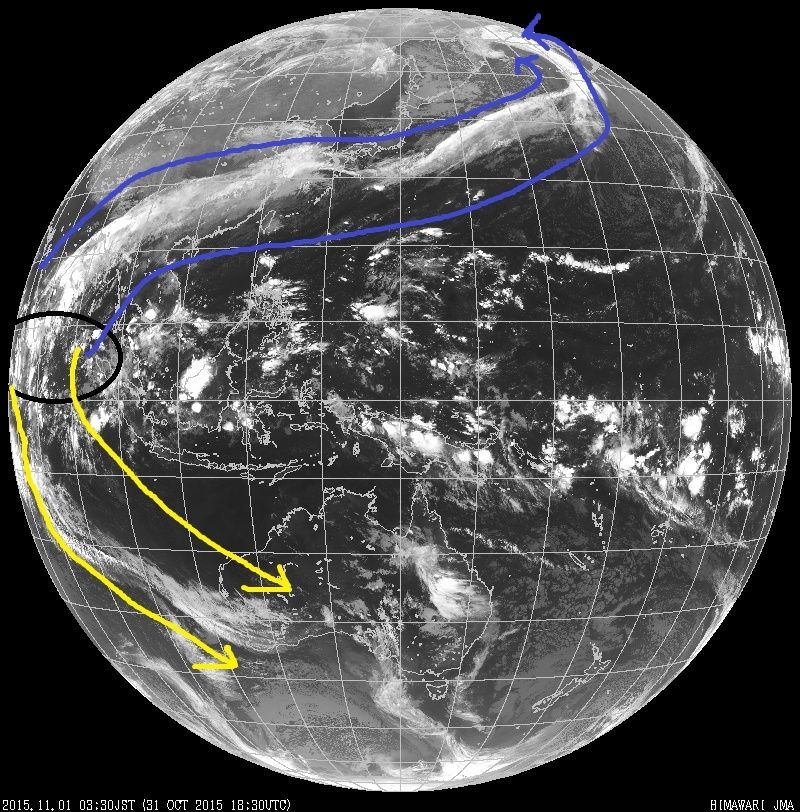 " />
" />Amazing sat loop. Click here to set the loop in motion. set animation speed to 0.1sec/image and animation for: last 24hrs then click play: It takes a minute to load. http://www.jma.go.jp/en/gms/index.html?area=6&element=0&mode=UTC
_________________
"In weather and in life, there's no winning and losing; there's only winning and learning."
WINTER 2012/2013 TOTALS 43.65"WINTER 2017/2018 TOTALS 62.85" WINTER 2022/2023 TOTALS 4.9"
WINTER 2013/2014 TOTALS 64.85"WINTER 2018/2019 TOTALS 14.25" WINTER 2023/2024 TOTALS 13.1"
WINTER 2014/2015 TOTALS 71.20"WINTER 2019/2020 TOTALS 6.35"
WINTER 2015/2016 TOTALS 35.00"WINTER 2020/2021 TOTALS 37.75"
WINTER 2016/2017 TOTALS 42.25"WINTER 2021/2022 TOTALS 31.65"
sroc4- Admin
- Posts : 8331
Reputation : 301
Join date : 2013-01-07
Location : Wading River, LI
Re: Long Range Thread 8.0
![]() by rb924119 Sat Oct 31, 2015 3:38 pm
by rb924119 Sat Oct 31, 2015 3:38 pm
rb924119- Meteorologist

- Posts : 6890
Reputation : 194
Join date : 2013-02-06
Age : 32
Location : Greentown, Pa
Re: Long Range Thread 8.0
![]() by rb924119 Sat Oct 31, 2015 3:59 pm
by rb924119 Sat Oct 31, 2015 3:59 pm
rb924119- Meteorologist
- Posts : 6890
Reputation : 194
Join date : 2013-02-06
Age : 32
Location : Greentown, Pa
Re: Long Range Thread 8.0
![]() by Frank_Wx Sat Oct 31, 2015 4:36 pm
by Frank_Wx Sat Oct 31, 2015 4:36 pm

_________________
_______________________________________________________________________________________________________
CLICK HERE to view NJ Strong Snowstorm Classifications
Frank_Wx- Godzilla Seeker
- Posts : 21305
Reputation : 328
Join date : 2013-01-05
Age : 31
Location : Jersey City, NJ -
Re: Long Range Thread 8.0
![]() by rb924119 Sat Oct 31, 2015 11:18 pm
by rb924119 Sat Oct 31, 2015 11:18 pm
Frank_Wx wrote:Rb, what do you know about decoupling? I've heard of that term but never understood how it works. For instance, 850mb zonal winds look pretty good over the tropical Pac and would result in forcing in favorable MJO regions. However, look at 200mb velocity potential. Pretty ugly.
To be honest, I don't know all that much about decoupling. The only times I've ever heard that term be used is when discussing the boundary layer (e.g. from 1000 hPa through approximately 850-700 hPa, or so, depending on where in the world you look) and surface. For example, when you get really good cold, clear nights in the winter, the surface and immediately above it decouple from the rest of the boundary, as there is zero momentum transfer due to the very strong inversion. Essentially you create two "separate", decoupled layers until mixing can erode that inversion and begin transferring momentum again. That said, I don't know how it does or could apply to the tropics; I'd have to look into that.
Secondly, velocity potential is a measure of DI-vergence, so positive values indicate divergence and negative values indicate convergence (the reason for this is due to the mathematics). In the tropics, convection is very simple; in, up and out. "In" at the lower levels, up, then "out" at the upper levels (really the Tropopause). So it makes sense that at 850 hPa you have strong convergence (negative values) while at 200 hPa you have strong divergence (positive values), as this pattern represents the vertical and also horizontal circulations associated with the convection.


So, yeah, I'd agree that based on those maps that forcing attributable to the MJO does look favorably placed
Unfortunately, there are also other factors at play :/ lol
rb924119- Meteorologist
- Posts : 6890
Reputation : 194
Join date : 2013-02-06
Age : 32
Location : Greentown, Pa
Re: Long Range Thread 8.0
![]() by sroc4 Sun Nov 01, 2015 4:36 am
by sroc4 Sun Nov 01, 2015 4:36 am
rb924119 wrote:Frank_Wx wrote:Rb, what do you know about decoupling? I've heard of that term but never understood how it works. For instance, 850mb zonal winds look pretty good over the tropical Pac and would result in forcing in favorable MJO regions. However, look at 200mb velocity potential. Pretty ugly.
To be honest, I don't know all that much about decoupling. The only times I've ever heard that term be used is when discussing the boundary layer (e.g. from 1000 hPa through approximately 850-700 hPa, or so, depending on where in the world you look) and surface. For example, when you get really good cold, clear nights in the winter, the surface and immediately above it decouple from the rest of the boundary, as there is zero momentum transfer due to the very strong inversion. Essentially you create two "separate", decoupled layers until mixing can erode that inversion and begin transferring momentum again. That said, I don't know how it does or could apply to the tropics; I'd have to look into that.
Secondly, velocity potential is a measure of DI-vergence, so positive values indicate divergence and negative values indicate convergence (the reason for this is due to the mathematics). In the tropics, convection is very simple; in, up and out. "In" at the lower levels, up, then "out" at the upper levels (really the Tropopause). So it makes sense that at 850 hPa you have strong convergence (negative values) while at 200 hPa you have strong divergence (positive values), as this pattern represents the vertical and also horizontal circulations associated with the convection.
So, yeah, I'd agree that based on those maps that forcing attributable to the MJO does look favorably placed
Unfortunately, there are also other factors at play :/ lol
Like what other factors one like myself might ask?
_________________
"In weather and in life, there's no winning and losing; there's only winning and learning."
WINTER 2012/2013 TOTALS 43.65"WINTER 2017/2018 TOTALS 62.85" WINTER 2022/2023 TOTALS 4.9"
WINTER 2013/2014 TOTALS 64.85"WINTER 2018/2019 TOTALS 14.25" WINTER 2023/2024 TOTALS 13.1"
WINTER 2014/2015 TOTALS 71.20"WINTER 2019/2020 TOTALS 6.35"
WINTER 2015/2016 TOTALS 35.00"WINTER 2020/2021 TOTALS 37.75"
WINTER 2016/2017 TOTALS 42.25"WINTER 2021/2022 TOTALS 31.65"
sroc4- Admin
- Posts : 8331
Reputation : 301
Join date : 2013-01-07
Location : Wading River, LI
Re: Long Range Thread 8.0
![]() by sroc4 Sun Nov 01, 2015 4:41 am
by sroc4 Sun Nov 01, 2015 4:41 am
rb924119 wrote:Ahhh the discussion as to where a particular piece of the atmosphere is located lol some things, such as 500 hPa vorticity are easy to measure; just pull up a water vapor loop and you can tell right where it is. Something like modes of tropical convection, such as Rossby/Kelvin waves and the MJO, have many metrics of measurement. 850 hPa velocity potential, 200 hPa velocity potential, OLR anomalies, surface convergence/divergence, which Eigenfunction you look at (e.g. RMM EOF 1 versus EOF 2). The list seems endless. Depending upon which metric you use, will determine which result you get.
Forget my last question as you answered it here.
_________________
"In weather and in life, there's no winning and losing; there's only winning and learning."
WINTER 2012/2013 TOTALS 43.65"WINTER 2017/2018 TOTALS 62.85" WINTER 2022/2023 TOTALS 4.9"
WINTER 2013/2014 TOTALS 64.85"WINTER 2018/2019 TOTALS 14.25" WINTER 2023/2024 TOTALS 13.1"
WINTER 2014/2015 TOTALS 71.20"WINTER 2019/2020 TOTALS 6.35"
WINTER 2015/2016 TOTALS 35.00"WINTER 2020/2021 TOTALS 37.75"
WINTER 2016/2017 TOTALS 42.25"WINTER 2021/2022 TOTALS 31.65"
sroc4- Admin
- Posts : 8331
Reputation : 301
Join date : 2013-01-07
Location : Wading River, LI
Re: Long Range Thread 8.0
![]() by Guest Sun Nov 01, 2015 8:54 am
by Guest Sun Nov 01, 2015 8:54 am
Guest- Guest
Re: Long Range Thread 8.0
![]() by rb924119 Sun Nov 01, 2015 9:48 am
by rb924119 Sun Nov 01, 2015 9:48 am
sroc4 wrote:rb924119 wrote:Ahhh the discussion as to where a particular piece of the atmosphere is located lol some things, such as 500 hPa vorticity are easy to measure; just pull up a water vapor loop and you can tell right where it is. Something like modes of tropical convection, such as Rossby/Kelvin waves and the MJO, have many metrics of measurement. 850 hPa velocity potential, 200 hPa velocity potential, OLR anomalies, surface convergence/divergence, which Eigenfunction you look at (e.g. RMM EOF 1 versus EOF 2). The list seems endless. Depending upon which metric you use, will determine which result you get.
Forget my last question as you answered it here.
I guess it does; but that was inadvertently unintentional lmao I just ran out of time to respond your question this morning. To answer your question, the other factors that came into my mind were factors such as the AO/NAO/EPO and activity of the tropics with respect to cyclones lol But yes, depending on which site(s) you use to study tropical wave modes, you can filter for certain criteria (such as removing feedback from active tropical cyclones, or other circulations) and this will very likely alter the results; some maybe substantially, while others in a more muted way.
rb924119- Meteorologist
- Posts : 6890
Reputation : 194
Join date : 2013-02-06
Age : 32
Location : Greentown, Pa
Re: Long Range Thread 8.0
![]() by rb924119 Sun Nov 01, 2015 9:51 am
by rb924119 Sun Nov 01, 2015 9:51 am
syosnow94 wrote:I love you maniacs. sroc, Frank, RB, Algae. All awake early morning after midnight discussing tropical forcing and inversions.

And the ONLY reason I was up at that hour was because of work haha I had the midnight to 0830 shift last night, so I figured I'd check in before I left ahaha Otherwise I would have been out colder than the Antarctic in July ahaha Unless there was a snowstorm brewing; then all bets are off and thoughts of pulling all-nighters may or may not enter my head lmfao
rb924119- Meteorologist
- Posts : 6890
Reputation : 194
Join date : 2013-02-06
Age : 32
Location : Greentown, Pa
Re: Long Range Thread 8.0
![]() by rb924119 Sun Nov 01, 2015 10:03 am
by rb924119 Sun Nov 01, 2015 10:03 am
Have been talking to Paulie the official blog observer and he brought up a great question about the Indian Ocean, and crazily enough, as I continue to find ways to explain why we have the winter we have, I was just playing around with that. Its just another case of how people that love the weather, have just as much talent and drive ( heck maybe more) than people that work in the field. Every now and then I look at forums and blogs, which are in reality the peer review system for the true weather lovers out there, and I am amazed at the talent level of people that love the weather. And I truly think that unless you live in our world, you have no idea of this, which may explain alot of the arrogance in academia or government in some matters. If they lived in this world, it would be a different world for alot, though not all, of them.
The strong phase 2 we are in now, is liable to repeat itself during the winter ( mainly 1/2) In the heart of winter, a strong phase 1/2 is a cold signal for the US

While we obviously dont expect it to be THIS COLD
.png)
, there are physical reasons for why we look for the MJO to be in favorable phases for the weatherbell.com idea Look at the water in the Indian ocean and the eastern Atlantic, its warmer than the last strong nino

So how does a snow loving optimist see all this. 1) Indian ocean favors more phase 1/2. 2) the warmer water further west in the PACIFIC near the equator and colder water to its north means the models with the further west upper trough idea there are correct. 3) The warm water off the east coast means, like last year, that as winter matures, the foe becomes friend for moisture laden storms with air cold enough for snow. 4) The place where it would be colder at the US latitudes would naturally, at the coldest time of the year in the mid and upper levels, be between where input regions are warm. Off the west coast, and off the east coast.
A pessimist. Its 1997 again, fuggeddabout it
I am an optimist
rb924119- Meteorologist
- Posts : 6890
Reputation : 194
Join date : 2013-02-06
Age : 32
Location : Greentown, Pa
Re: Long Range Thread 8.0
![]() by rb924119 Sun Nov 01, 2015 10:08 am
by rb924119 Sun Nov 01, 2015 10:08 am
CFSV2 though still in its own world for the winter against most modeling and are ideas, is seeing it our way with the Enso SST the current difference between Enso 3.4 and 1.2 is about .2c but expands to over 1C during winter
.gif)
.gif)
The recent runs show a very sharp drop off, which will further expand the difference between this and the dreaded 1997 enso event
rb924119- Meteorologist
- Posts : 6890
Reputation : 194
Join date : 2013-02-06
Age : 32
Location : Greentown, Pa
Re: Long Range Thread 8.0
![]() by sroc4 Sun Nov 01, 2015 10:49 am
by sroc4 Sun Nov 01, 2015 10:49 am
syosnow94 wrote:I love you maniacs. sroc, Frank, RB, Algae. All awake early morning after midnight discussing tropical forcing and inversions.
Lol. For the record Syo I drank a fair share of adult frosty beverages last night and so I was up because well let's just say nature called. Lol. As I was sipping a large glass of water and medicating with 3 Advil to tame the headache I happen to check out my favorite weather board and found some interesting discussion. Yeah I'm a weather geek and proud of it.

_________________
"In weather and in life, there's no winning and losing; there's only winning and learning."
WINTER 2012/2013 TOTALS 43.65"WINTER 2017/2018 TOTALS 62.85" WINTER 2022/2023 TOTALS 4.9"
WINTER 2013/2014 TOTALS 64.85"WINTER 2018/2019 TOTALS 14.25" WINTER 2023/2024 TOTALS 13.1"
WINTER 2014/2015 TOTALS 71.20"WINTER 2019/2020 TOTALS 6.35"
WINTER 2015/2016 TOTALS 35.00"WINTER 2020/2021 TOTALS 37.75"
WINTER 2016/2017 TOTALS 42.25"WINTER 2021/2022 TOTALS 31.65"
sroc4- Admin
- Posts : 8331
Reputation : 301
Join date : 2013-01-07
Location : Wading River, LI
Re: Long Range Thread 8.0
![]() by algae888 Sun Nov 01, 2015 12:35 pm
by algae888 Sun Nov 01, 2015 12:35 pm
and here it is on today's 12z gfs..Frank_Wx wrote:Models are hinting on another coastal system around the 9th. Would be in the form of rain.


I will take this set up all winter. maybe a little snow n/w suburbs?

algae888- Advanced Forecaster
- Posts : 5311
Reputation : 46
Join date : 2013-02-05
Age : 61
Location : mt. vernon, new york
Re: Long Range Thread 8.0
![]() by amugs Sun Nov 01, 2015 1:00 pm
by amugs Sun Nov 01, 2015 1:00 pm
JB post is a definite reassurance of what is to come this winter and Rb thanks for posting. I have been researching the aspect of the IO (Indian Ocean) in NINO's and how it plays a major role in where the trop forcing sets up. BTW, Paulie he is referrring to is his buddy who is on the USA -WX forum and someone who I have pm's with and asked him this as well ( what role the IO has to play Nino?). It has been theorized that if you have warm waters in the IO with a basin wide Nino the forcing usually stays in the 8,1,2 phase and doesn't allow it to escape and go around the horn per say. How does this happen, pretty technical but in a nutshell the warm waters and air form a block so to speak and I think Rb explained this in his dissertation paper he posted on this site. Again this is a theory that scientist and weather enthusiasts are investigating. Reading the posts above can make one head spin for all the tech jargon and as Rb stated that you can use 5 different maps to look at things - 200hp, 500hp, OLRs, yada yada yada but here is the fact - 1.2 cooling and 3.4 and 4 warming. The IO is in our favor and tomorrow we find out from our fearless leader what we have in store this winter - positive juju here peeps.
Look at the charts - see ya and hate to be ya 1.2 - get oudda here !!

3 - going down as well with 1.2 - bye bye

3.4

4

Remember this - the water depth of the nino waters are deeper in these last two regions so it will take lounger to cool.
_________________
Mugs
AKA:King: Snow Weenie
Self Proclaimed
WINTER 2014-15 : 55.12" +.02 for 6 coatings (avg. 35")
WINTER 2015-16 Total - 29.8" (Avg 35")
WINTER 2016-17 : 39.5" so far

amugs- Advanced Forecaster - Mod

- Posts : 15093
Reputation : 213
Join date : 2013-01-07
Age : 54
Location : Hillsdale,NJ
Re: Long Range Thread 8.0
![]() by Frank_Wx Sun Nov 01, 2015 1:02 pm
by Frank_Wx Sun Nov 01, 2015 1:02 pm
_________________
_______________________________________________________________________________________________________
CLICK HERE to view NJ Strong Snowstorm Classifications
Frank_Wx- Godzilla Seeker
- Posts : 21305
Reputation : 328
Join date : 2013-01-05
Age : 31
Location : Jersey City, NJ -
Re: Long Range Thread 8.0
![]() by Dunnzoo Sun Nov 01, 2015 1:13 pm
by Dunnzoo Sun Nov 01, 2015 1:13 pm
Frank_Wx wrote:Finally....FINALLY finished the winter outlook. Holy crap I thought this day would never come considering I started it October 1st.
and you are going to make us wait until tomorrow?????
_________________
Janet
Snowfall winter of 2023-2024 17.5"
Snowfall winter of 2022-2023 6.0"
Snowfall winter of 2021-2022 17.6" 1" sleet 2/25/22
Snowfall winter of 2020-2021 51.1"
Snowfall winter of 2019-2020 8.5"
Snowfall winter of 2018-2019 25.1"
Snowfall winter of 2017-2018 51.9"
Snowfall winter of 2016-2017 45.6"
Snowfall winter of 2015-2016 29.5"
Snowfall winter of 2014-2015 50.55"
Snowfall winter of 2013-2014 66.5"

Dunnzoo- Senior Enthusiast - Mod
- Posts : 4892
Reputation : 68
Join date : 2013-01-11
Age : 62
Location : Westwood, NJ
Re: Long Range Thread 8.0
![]() by Frank_Wx Sun Nov 01, 2015 1:16 pm
by Frank_Wx Sun Nov 01, 2015 1:16 pm
Dunnzoo wrote:Frank_Wx wrote:Finally....FINALLY finished the winter outlook. Holy crap I thought this day would never come considering I started it October 1st.
and you are going to make us wait until tomorrow?????
Yes. Yes I am cause I feel like it!
_________________
_______________________________________________________________________________________________________
CLICK HERE to view NJ Strong Snowstorm Classifications
Frank_Wx- Godzilla Seeker
- Posts : 21305
Reputation : 328
Join date : 2013-01-05
Age : 31
Location : Jersey City, NJ -
Re: Long Range Thread 8.0
![]() by docstox12 Sun Nov 01, 2015 1:37 pm
by docstox12 Sun Nov 01, 2015 1:37 pm

docstox12- Wx Statistician Guru

- Posts : 8507
Reputation : 222
Join date : 2013-01-07
Age : 73
Location : Monroe NY
Re: Long Range Thread 8.0
![]() by skinsfan1177 Sun Nov 01, 2015 2:24 pm
by skinsfan1177 Sun Nov 01, 2015 2:24 pm

skinsfan1177- Senior Enthusiast

- Posts : 4485
Reputation : 35
Join date : 2013-01-07
Age : 46
Location : Point Pleasant Boro
Re: Long Range Thread 8.0
![]() by devsman Sun Nov 01, 2015 3:35 pm
by devsman Sun Nov 01, 2015 3:35 pm
Frank_Wx wrote:Dunnzoo wrote:Frank_Wx wrote:Finally....FINALLY finished the winter outlook. Holy crap I thought this day would never come considering I started it October 1st.
and you are going to make us wait until tomorrow?????
Yes. Yes I am cause I feel like it!
Just answer this, Will we be happy or sad?

devsman- Pro Enthusiast

- Posts : 424
Reputation : 4
Join date : 2014-01-01
Age : 48
Location : merrick, ny (south shore of Long Island)
Page 30 of 40 • 1 ... 16 ... 29, 30, 31 ... 35 ... 40 ![]()
|
|
|