
 Search
Long Range Thread 8.0
Page 31 of 40 •  1 ... 17 ... 30, 31, 32 ... 35 ... 40
 ![]()
Re: Long Range Thread 8.0
![]() by skinsfan1177 Sun Nov 01, 2015 2:24 pm
by skinsfan1177 Sun Nov 01, 2015 2:24 pm
skinsfan1177- Senior Enthusiast

- Posts : 4485
Join date : 2013-01-07
Re: Long Range Thread 8.0
![]() by devsman Sun Nov 01, 2015 3:35 pm
by devsman Sun Nov 01, 2015 3:35 pm
Frank_Wx wrote:Dunnzoo wrote:Frank_Wx wrote:Finally....FINALLY finished the winter outlook. Holy crap I thought this day would never come considering I started it October 1st.
and you are going to make us wait until tomorrow?????
Yes. Yes I am cause I feel like it!
Just answer this, Will we be happy or sad?
devsman- Pro Enthusiast

- Posts : 424
Join date : 2014-01-01
Re: Long Range Thread 8.0
![]() by Frank_Wx Sun Nov 01, 2015 3:41 pm
by Frank_Wx Sun Nov 01, 2015 3:41 pm
devsman wrote:Frank_Wx wrote:Dunnzoo wrote:Frank_Wx wrote:Finally....FINALLY finished the winter outlook. Holy crap I thought this day would never come considering I started it October 1st.
and you are going to make us wait until tomorrow?????
Yes. Yes I am cause I feel like it!
Just answer this, Will we be happy or sad?
Mixed emotions
_________________
_______________________________________________________________________________________________________
CLICK HERE to view NJ Strong Snowstorm Classifications

Frank_Wx- Godzilla Seeker

- Posts : 21305
Reputation : 328
Join date : 2013-01-05
Age : 31
Location : Jersey City, NJ -

Re: Long Range Thread 8.0
![]() by Frank_Wx Sun Nov 01, 2015 4:18 pm
by Frank_Wx Sun Nov 01, 2015 4:18 pm

This type of pattern continues into week 2, though it looks a little more seasonable over our area by then.

Madonne, the EURO ensembles have this warmth lasting into mid month.

_________________
_______________________________________________________________________________________________________
CLICK HERE to view NJ Strong Snowstorm Classifications
Frank_Wx- Godzilla Seeker
- Posts : 21305
Reputation : 328
Join date : 2013-01-05
Age : 31
Location : Jersey City, NJ -
Re: Long Range Thread 8.0
![]() by nutleyblizzard Sun Nov 01, 2015 5:29 pm
by nutleyblizzard Sun Nov 01, 2015 5:29 pm
That's fine by me. I'll be able to put up the xmas lights without running in and out of the house with the cold air that I usually endure most years. Besides, cold is a waste to me in November.Frank_Wx wrote:Deep trough in the west coupled with low heights over the Arctic and Canada will allow the southeast ridge to amplify over the eastern U.S. this week.
This type of pattern continues into week 2, though it looks a little more seasonable over our area by then.
Madonne, the EURO ensembles have this warmth lasting into mid month.

nutleyblizzard- Senior Enthusiast
- Posts : 1952
Reputation : 41
Join date : 2014-01-30
Age : 58
Location : Nutley, new jersey
Re: Long Range Thread 8.0
![]() by Frank_Wx Sun Nov 01, 2015 8:35 pm
by Frank_Wx Sun Nov 01, 2015 8:35 pm
https://onedrive.live.com/view.aspx?cid=1ca2f9a16d1a6375&id=documents&resid=1CA2F9A16D1A6375%21268&app=PowerPoint&authkey=!AAz7tHdraRa2A3A&&wdSlideId=256&wdModeSwitchTime=1446427420673
_________________
_______________________________________________________________________________________________________
CLICK HERE to view NJ Strong Snowstorm Classifications
Frank_Wx- Godzilla Seeker
- Posts : 21305
Reputation : 328
Join date : 2013-01-05
Age : 31
Location : Jersey City, NJ -
Re: Long Range Thread 8.0
![]() by amugs Sun Nov 01, 2015 10:38 pm
by amugs Sun Nov 01, 2015 10:38 pm
Frank_Wx wrote:Did anyone notice in DTs winter outlook he didn't make a forecast? He really has no clue and would rather wait until December to lean one way or another.
https://onedrive.live.com/view.aspx?cid=1ca2f9a16d1a6375&id=documents&resid=1CA2F9A16D1A6375%21268&app=PowerPoint&authkey=!AAz7tHdraRa2A3A&&wdSlideId=256&wdModeSwitchTime=1446427420673
Great PP - he makes fun of NOAA and TWC, Also provides very good information and questions that could sway the winter one way or the other. I think we have to read in between in lines and infer what he is saying - we punt DEC and have a back loaded winter as a few have said (one that I am leaning towards as well).
Lless than 12 hours and we find out what the great OZ has to say.
I will give a Siberian snow update tomorrow - almost the end of the snow growth charts for the winter.
_________________
Mugs
AKA:King: Snow Weenie
Self Proclaimed
WINTER 2014-15 : 55.12" +.02 for 6 coatings (avg. 35")
WINTER 2015-16 Total - 29.8" (Avg 35")
WINTER 2016-17 : 39.5" so far

amugs- Advanced Forecaster - Mod

- Posts : 15093
Reputation : 213
Join date : 2013-01-07
Age : 54
Location : Hillsdale,NJ
Re: Long Range Thread 8.0
![]() by amugs Mon Nov 02, 2015 7:43 am
by amugs Mon Nov 02, 2015 7:43 am
21OCT2015 2.2 2.6 2.5 1.3
28OCT2015 2.3 2.8 2.7 1.4
Region 3.4 and 4 Nice and toasty - don't worry about slight up tick in 1.2 said this would happen due to a kelvin wave, WWB that was progged but going downhill after this. Look at the warming from region 3 and west - important for winter!
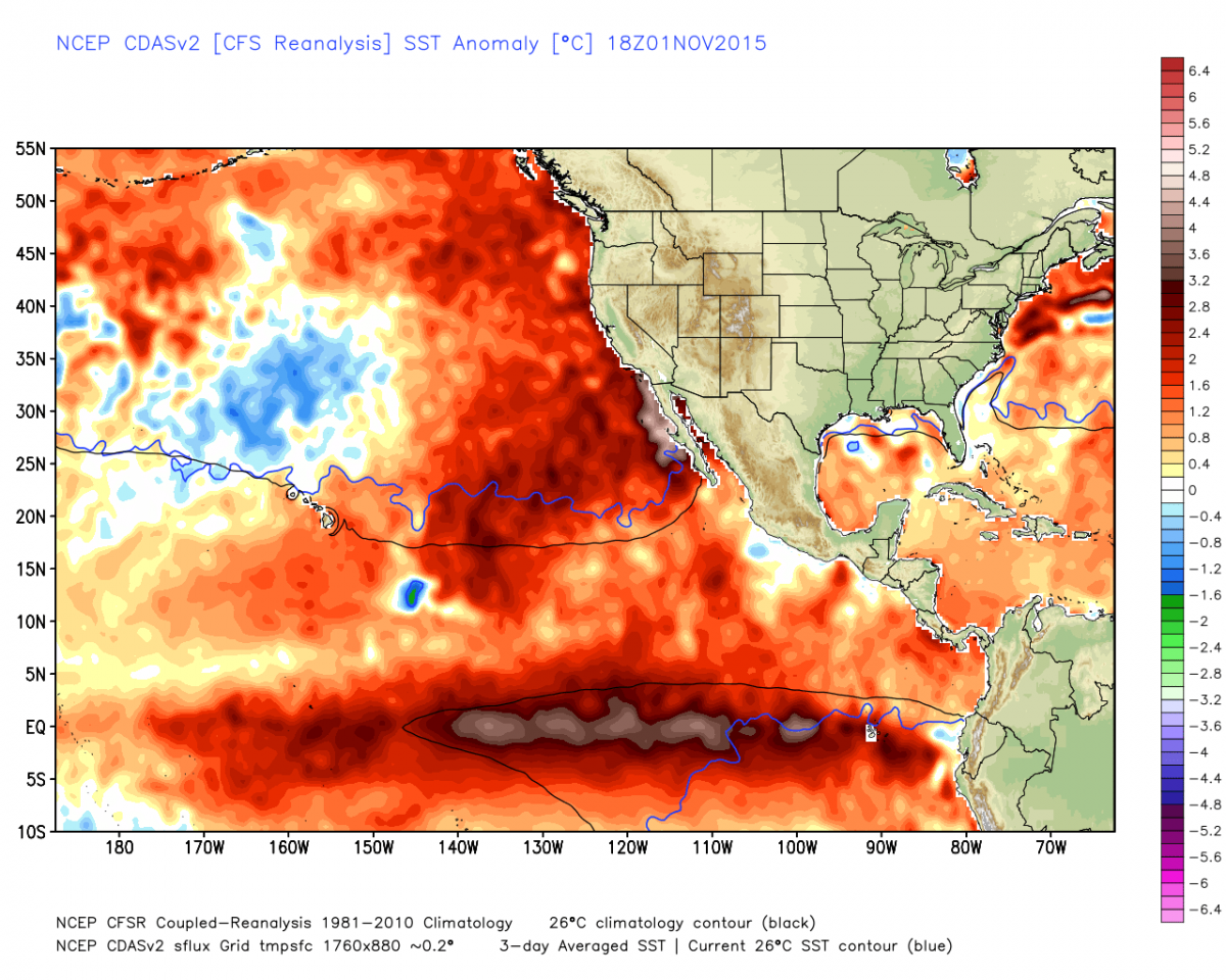
AND..................look at the blob off the Baja and SC coast - this is our +PDO
_________________
Mugs
AKA:King: Snow Weenie
Self Proclaimed
WINTER 2014-15 : 55.12" +.02 for 6 coatings (avg. 35")
WINTER 2015-16 Total - 29.8" (Avg 35")
WINTER 2016-17 : 39.5" so far
amugs- Advanced Forecaster - Mod
- Posts : 15093
Reputation : 213
Join date : 2013-01-07
Age : 54
Location : Hillsdale,NJ
Re: Long Range Thread 8.0
![]() by amugs Mon Nov 02, 2015 9:37 am
by amugs Mon Nov 02, 2015 9:37 am

_________________
Mugs
AKA:King: Snow Weenie
Self Proclaimed
WINTER 2014-15 : 55.12" +.02 for 6 coatings (avg. 35")
WINTER 2015-16 Total - 29.8" (Avg 35")
WINTER 2016-17 : 39.5" so far
amugs- Advanced Forecaster - Mod
- Posts : 15093
Reputation : 213
Join date : 2013-01-07
Age : 54
Location : Hillsdale,NJ
Re: Long Range Thread 8.0
![]() by amugs Mon Nov 02, 2015 12:33 pm
by amugs Mon Nov 02, 2015 12:33 pm
_________________
Mugs
AKA:King: Snow Weenie
Self Proclaimed
WINTER 2014-15 : 55.12" +.02 for 6 coatings (avg. 35")
WINTER 2015-16 Total - 29.8" (Avg 35")
WINTER 2016-17 : 39.5" so far
amugs- Advanced Forecaster - Mod
- Posts : 15093
Reputation : 213
Join date : 2013-01-07
Age : 54
Location : Hillsdale,NJ
Re: Long Range Thread 8.0
![]() by amugs Mon Nov 02, 2015 1:22 pm
by amugs Mon Nov 02, 2015 1:22 pm
Rocky went from this back in Sept (when I start tracking our snow growth along with other members here):
To this presently:

Isnt he beautiful, fille din so nicely. fluffy, deep and thick pack.
Now for the real graphics:
OCT 1st

OCT 31ST

NOV 1ST


KAABOOOOOOOOOOOOMMMMMMMMMMMMMMMMMM!!!!!!!!!!!
FROM THE INFORMATION - chart above and now maps you can see we have a very good snow pack for this upcoming winter, so the cold air source is there and ready to go to work for us IF we can get "other" atmospheric dynamics to help out it can good to great.
_________________
Mugs
AKA:King: Snow Weenie
Self Proclaimed
WINTER 2014-15 : 55.12" +.02 for 6 coatings (avg. 35")
WINTER 2015-16 Total - 29.8" (Avg 35")
WINTER 2016-17 : 39.5" so far
amugs- Advanced Forecaster - Mod
- Posts : 15093
Reputation : 213
Join date : 2013-01-07
Age : 54
Location : Hillsdale,NJ
Re: Long Range Thread 8.0
![]() by amugs Mon Nov 02, 2015 3:52 pm
by amugs Mon Nov 02, 2015 3:52 pm
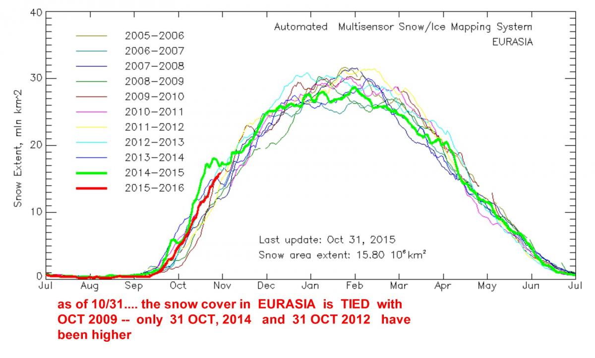
So far this October, Siberian snow cover has advanced more rapidly than normal though not as fast as the two most recent Octobers. October Eurasian snow cover extent was above normal but within one standard deviation. Another index that we compute the snow advance index was more strongly above normal, over one standard deviation.
Arctic sea ice in the Barents Kara seas is below normal and certainly less extensive than last year at this time. We consider these two factors to favor a negative winter AO and therefore a relatively cold winter across the Northern Hemisphere continents in the mid-latitudes. Finally high latitude blocking has been above normal so far this October. However, the model forecast of the geopotential height fields for the foreseeable future does not currently project on to the pattern that favors increased energy transfer from the troposphere to the stratosphere that eventually warms the polar stratosphere and weakens the polar vortex. Still, a shift in the atmospheric pattern would favor an increase in vertical energy transfer and needs to be watched closely. In addition, we also have one of the strongest observed El Niños ongoing that is predicted to last through the winter, though recent model forecasts show a dramatic decline in strength through the winter months. El Niño is thought to force milder winters across the extratopical Northern Hemisphere. It is challenging to anticipate how the final outcome of competing forcings from the tropics and the high latitudes will influence mid-latitude weather.
So basically, we will want to see a shift in the November pattern later in the month to promote more heat transfer into the upper troposphere and stratosphere...the first half of the month looks hostile to this
_________________
Mugs
AKA:King: Snow Weenie
Self Proclaimed
WINTER 2014-15 : 55.12" +.02 for 6 coatings (avg. 35")
WINTER 2015-16 Total - 29.8" (Avg 35")
WINTER 2016-17 : 39.5" so far
amugs- Advanced Forecaster - Mod
- Posts : 15093
Reputation : 213
Join date : 2013-01-07
Age : 54
Location : Hillsdale,NJ
Re: Long Range Thread 8.0
![]() by Frank_Wx Mon Nov 02, 2015 4:40 pm
by Frank_Wx Mon Nov 02, 2015 4:40 pm
amugs wrote:This from Cohen -Cohen updated....the key nuggets for those interested in SAI/SCE:
So far this October, Siberian snow cover has advanced more rapidly than normal though not as fast as the two most recent Octobers. October Eurasian snow cover extent was above normal but within one standard deviation. Another index that we compute the snow advance index was more strongly above normal, over one standard deviation.
Arctic sea ice in the Barents Kara seas is below normal and certainly less extensive than last year at this time. We consider these two factors to favor a negative winter AO and therefore a relatively cold winter across the Northern Hemisphere continents in the mid-latitudes. Finally high latitude blocking has been above normal so far this October. However, the model forecast of the geopotential height fields for the foreseeable future does not currently project on to the pattern that favors increased energy transfer from the troposphere to the stratosphere that eventually warms the polar stratosphere and weakens the polar vortex. Still, a shift in the atmospheric pattern would favor an increase in vertical energy transfer and needs to be watched closely. In addition, we also have one of the strongest observed El Niños ongoing that is predicted to last through the winter, though recent model forecasts show a dramatic decline in strength through the winter months. El Niño is thought to force milder winters across the extratopical Northern Hemisphere. It is challenging to anticipate how the final outcome of competing forcings from the tropics and the high latitudes will influence mid-latitude weather.
So basically, we will want to see a shift in the November pattern later in the month to promote more heat transfer into the upper troposphere and stratosphere...the first half of the month looks hostile to this
The part of Cohen's paragraph I bolded in blue text I do not expect to happen until mid to late December. He's basically saying the pattern needs to change in order for the NAO/AO to go negative again. He just does not say when that will happen. If you read my winter outlook, you'll have an idea of when this could happen. When it does, colder temps will spread into the northeast.
_________________
_______________________________________________________________________________________________________
CLICK HERE to view NJ Strong Snowstorm Classifications
Frank_Wx- Godzilla Seeker
- Posts : 21305
Reputation : 328
Join date : 2013-01-05
Age : 31
Location : Jersey City, NJ -
Re: Long Range Thread 8.0
![]() by dkodgis Mon Nov 02, 2015 4:41 pm
by dkodgis Mon Nov 02, 2015 4:41 pm
the Blob is a troublesome thing...

dkodgis- Senior Enthusiast
- Posts : 2501
Reputation : 98
Join date : 2013-12-29
Re: Long Range Thread 8.0
![]() by Frank_Wx Mon Nov 02, 2015 4:43 pm
by Frank_Wx Mon Nov 02, 2015 4:43 pm
amugs wrote:This is not as in depth as Franks write up HAHAHA but here we go (more humor on my end):
Rocky went from this back in Sept (when I start tracking our snow growth along with other members here):
To this presently:
Isnt he beautiful, fille din so nicely. fluffy, deep and thick pack.
Now for the real graphics:
OCT 1st
OCT 31ST
NOV 1ST
KAABOOOOOOOOOOOOMMMMMMMMMMMMMMMMMM!!!!!!!!!!!
FROM THE INFORMATION - chart above and now maps you can see we have a very good snow pack for this upcoming winter, so the cold air source is there and ready to go to work for us IF we can get "other" atmospheric dynamics to help out it can good to great.
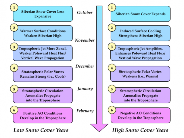
Yup - keep in mind getting snow build up across NH is just one step to the process. We need to see other features begin to happen. Refer to the right column on the image below. This is the timeline our atmosphere tends and needs to follow in order for the -AO to come to fruition. I'll be keeping track of this "checklist" extensively.
_________________
_______________________________________________________________________________________________________
CLICK HERE to view NJ Strong Snowstorm Classifications
Frank_Wx- Godzilla Seeker
- Posts : 21305
Reputation : 328
Join date : 2013-01-05
Age : 31
Location : Jersey City, NJ -
Re: Long Range Thread 8.0
![]() by Frank_Wx Mon Nov 02, 2015 4:49 pm
by Frank_Wx Mon Nov 02, 2015 4:49 pm
dkodgis wrote:http://www.nytimes.com/2015/11/03/science/global-warming-pacific-ocean-el-nino-blob.html?hp&action=click&pgtype=Homepage&module=photo-spot-region®ion=top-news&WT.nav=top-news&_r=0
the Blob is a troublesome thing...
This article is nothing more than Global Warming propaganda. The "blob" is not an actual thing. This is the PDO we're talking about and amateur weather enthusiasts or Meteorologists such as this author keep confusing the two. The PDO comes in cycles and its phases can last for many years. For example, there was a period of -PDO (or below normal north Pacific SSTA's) that lasted for almost 20 years in the late 20th century. This image does a nice job showing how long some PDO events can last. We just happen to be in a +PDO phase while a strong El Nino is occurring and people are up in arms about it. +PDO's HAPPEN ALL THE TIME AND COULD LAST FOR 5, 10, 20, or 30 years straight!

_________________
_______________________________________________________________________________________________________
CLICK HERE to view NJ Strong Snowstorm Classifications
Frank_Wx- Godzilla Seeker
- Posts : 21305
Reputation : 328
Join date : 2013-01-05
Age : 31
Location : Jersey City, NJ -
Re: Long Range Thread 8.0
![]() by dkodgis Mon Nov 02, 2015 4:55 pm
by dkodgis Mon Nov 02, 2015 4:55 pm
dkodgis- Senior Enthusiast
- Posts : 2501
Reputation : 98
Join date : 2013-12-29
Re: Long Range Thread 8.0
![]() by amugs Mon Nov 02, 2015 6:45 pm
by amugs Mon Nov 02, 2015 6:45 pm
All business I see Paisan.
_________________
Mugs
AKA:King: Snow Weenie
Self Proclaimed
WINTER 2014-15 : 55.12" +.02 for 6 coatings (avg. 35")
WINTER 2015-16 Total - 29.8" (Avg 35")
WINTER 2016-17 : 39.5" so far
amugs- Advanced Forecaster - Mod
- Posts : 15093
Reputation : 213
Join date : 2013-01-07
Age : 54
Location : Hillsdale,NJ
Re: Long Range Thread 8.0
![]() by amugs Mon Nov 02, 2015 7:12 pm
by amugs Mon Nov 02, 2015 7:12 pm
Here is plot from his site on the AO

_________________
Mugs
AKA:King: Snow Weenie
Self Proclaimed
WINTER 2014-15 : 55.12" +.02 for 6 coatings (avg. 35")
WINTER 2015-16 Total - 29.8" (Avg 35")
WINTER 2016-17 : 39.5" so far
amugs- Advanced Forecaster - Mod
- Posts : 15093
Reputation : 213
Join date : 2013-01-07
Age : 54
Location : Hillsdale,NJ
Re: Long Range Thread 8.0
![]() by Frank_Wx Mon Nov 02, 2015 7:22 pm
by Frank_Wx Mon Nov 02, 2015 7:22 pm
dkodgis wrote:And the article was from the NY Times. I teach research writing, English Comp, etc. in on-the-ground classes and also online. No newspaper is a scholarly source but it is a sad day when the NY Times engages in shoddy journalism. Of course, I expected more from the newspaper but I do not have the background or expertise to smell this out. Thanks for showing why the article has misconceptions.
No problem! And don't be discouraged from posting those types of articles. I always enjoy trying to prove them wrong.
amugs wrote:@ Frank - no comment on Rocky?
All business I see Paisan.
Rocky is hilarious, Mugs. I actually think your analogy with a cheetah pet and the Siberian snow growth is absolutely awesome.
amugs wrote:Missed this on Cohen Discussion of AO state " However with more troughing predicted in western North America, a more rapid advance in snow cover for this region has began and is expected to continue through mid November"
Here is plot from his site on the AO
Interesting graphic. A gradual decline toward negative makes sense.
_________________
_______________________________________________________________________________________________________
CLICK HERE to view NJ Strong Snowstorm Classifications
Frank_Wx- Godzilla Seeker
- Posts : 21305
Reputation : 328
Join date : 2013-01-05
Age : 31
Location : Jersey City, NJ -
Re: Long Range Thread 8.0
![]() by Frank_Wx Mon Nov 02, 2015 7:22 pm
by Frank_Wx Mon Nov 02, 2015 7:22 pm
The red line is the quick moving and weak cold front that will bring light showers and below normal temps to our area this weekend. The red circle over the western U.S. is the next ridge for NEXT week that will bring more warm temperatures to the northeast. The reason why we're seeing an abundance of warmth is because mild Pacific air is "flooding" the country thanks to the anomalous trough over the Northeast Pacific Ocean and Alaska.
As long as that trough is there, we'll continue to remain on the warmer side from normal.

_________________
_______________________________________________________________________________________________________
CLICK HERE to view NJ Strong Snowstorm Classifications
Frank_Wx- Godzilla Seeker
- Posts : 21305
Reputation : 328
Join date : 2013-01-05
Age : 31
Location : Jersey City, NJ -
Re: Long Range Thread 8.0
![]() by HectorO Mon Nov 02, 2015 7:59 pm
by HectorO Mon Nov 02, 2015 7:59 pm
Frank_Wx wrote:Did anyone notice in DTs winter outlook he didn't make a forecast? He really has no clue and would rather wait until December to lean one way or another.
https://onedrive.live.com/view.aspx?cid=1ca2f9a16d1a6375&id=documents&resid=1CA2F9A16D1A6375%21268&app=PowerPoint&authkey=!AAz7tHdraRa2A3A&&wdSlideId=256&wdModeSwitchTime=1446427420673
I don't think it's a bad idea to wait a bit. A lot changes. Some of the early October predictions and Even 1st of November seems a bit early to me. We'll see!

HectorO- Pro Enthusiast
- Posts : 959
Reputation : 27
Join date : 2013-01-11
Re: Long Range Thread 8.0
![]() by HectorO Mon Nov 02, 2015 8:04 pm
by HectorO Mon Nov 02, 2015 8:04 pm
amugs wrote:This is not as in depth as Franks write up HAHAHA but here we go (more humor on my end):
Rocky went from this back in Sept (when I start tracking our snow growth along with other members here):
To this presently:
Isnt he beautiful, fille din so nicely. fluffy, deep and thick pack.
Now for the real graphics:
OCT 1st
OCT 31ST
NOV 1ST
KAABOOOOOOOOOOOOMMMMMMMMMMMMMMMMMM!!!!!!!!!!!
FROM THE INFORMATION - chart above and now maps you can see we have a very good snow pack for this upcoming winter, so the cold air source is there and ready to go to work for us IF we can get "other" atmospheric dynamics to help out it can good to great.
LOL If I didn't know any better, It looks like the latest picture was taken from the chia website
HectorO- Pro Enthusiast
- Posts : 959
Reputation : 27
Join date : 2013-01-11
Re: Long Range Thread 8.0
![]() by Math23x7 Mon Nov 02, 2015 8:30 pm
by Math23x7 Mon Nov 02, 2015 8:30 pm
11/2/09:
AO: +2.689
NAO: +1.288
PNA: -0.092
11/2/15:
AO: +3.3660
NAO: +1.4498
PNA: -0.57377
Just some food for thought.
Math23x7- Wx Statistician Guru

- Posts : 2379
Reputation : 68
Join date : 2013-01-08
Re: Long Range Thread 8.0
![]() by amugs Mon Nov 02, 2015 9:31 pm
by amugs Mon Nov 02, 2015 9:31 pm
@ Mikey (math) love the parallel and statistical comparison. Let's hope the fruits I'd this data come to fruition
_________________
Mugs
AKA:King: Snow Weenie
Self Proclaimed
WINTER 2014-15 : 55.12" +.02 for 6 coatings (avg. 35")
WINTER 2015-16 Total - 29.8" (Avg 35")
WINTER 2016-17 : 39.5" so far
amugs- Advanced Forecaster - Mod
- Posts : 15093
Reputation : 213
Join date : 2013-01-07
Age : 54
Location : Hillsdale,NJ
Re: Long Range Thread 8.0
![]() by amugs Mon Nov 02, 2015 10:10 pm
by amugs Mon Nov 02, 2015 10:10 pm
Math23x7 wrote:I just looked at CPC's teleconnections from both past and present and saw some interesting comparisons between November 2nd, 2015 and November 2nd, 2009:
11/2/09:
AO: +2.689
NAO: +1.288
PNA: -0.092
11/2/15:
AO: +3.3660
NAO: +1.4498
PNA: -0.57377
Just some food for thought.
Mike look at 2003 as well for a comparison too.
_________________
Mugs
AKA:King: Snow Weenie
Self Proclaimed
WINTER 2014-15 : 55.12" +.02 for 6 coatings (avg. 35")
WINTER 2015-16 Total - 29.8" (Avg 35")
WINTER 2016-17 : 39.5" so far
amugs- Advanced Forecaster - Mod
- Posts : 15093
Reputation : 213
Join date : 2013-01-07
Age : 54
Location : Hillsdale,NJ
Re: Long Range Thread 8.0
![]() by Math23x7 Mon Nov 02, 2015 10:36 pm
by Math23x7 Mon Nov 02, 2015 10:36 pm
Math23x7- Wx Statistician Guru
- Posts : 2379
Reputation : 68
Join date : 2013-01-08
Page 31 of 40 • 1 ... 17 ... 30, 31, 32 ... 35 ... 40 ![]()
|
|
|