
 Search
Long Range Thread 8.0
Page 39 of 40 •  1 ... 21 ... 38, 39, 40
 ![]()
Re: Long Range Thread 8.0
![]() by algae888 Fri Nov 13, 2015 9:03 pm
by algae888 Fri Nov 13, 2015 9:03 pm

hoping models hold on to this pattern shift. can't wait to hear scott and frank's thoughts
algae888- Advanced Forecaster

- Posts : 5311
Join date : 2013-02-05
Re: Long Range Thread 8.0
![]() by rb924119 Sat Nov 14, 2015 2:06 am
by rb924119 Sat Nov 14, 2015 2:06 am
Tonight's 00z GFS Op:

That Omega is literally off the charts. Crazy.
rb924119- Meteorologist

- Posts : 6889
Join date : 2013-02-06
Re: Long Range Thread 8.0
![]() by rb924119 Sat Nov 14, 2015 2:08 am
by rb924119 Sat Nov 14, 2015 2:08 am

rb924119- Meteorologist
- Posts : 6889
Reputation : 194
Join date : 2013-02-06
Age : 32
Location : Greentown, Pa
Re: Long Range Thread 8.0
![]() by sroc4 Sat Nov 14, 2015 7:50 am
by sroc4 Sat Nov 14, 2015 7:50 am
Let me start by saying I am not impressed with anything that locks us into anything. I will try my best to not use the term transient here because the back and fourth is what this time of year is typically about in the northern hemisphere. So maybe the phrase...the pattern is locking into a transient pattern.... is more appropriate. Or perhaps the phrase,...the pattern def looks like it is continuing to evolve to what we want it to.
One of the main drivers, if not the main driver, of the winter pattern over N America the last two winters has been due to the warm pool in the Gulf of Alaska(GOA). This feauture will once again play a vital role in how the winter pattern plays out. This above normal SST anomaly has led to a -EPO which means a trough sets up south of the Aleutian Islands, and a ridge complex establishes itself in the GOA and up into Alaska. Down stream from this type of set up typically leads to a trough that digs into the CONUS. But we have yet to establish that -EPO as of yet. We have actually had a +EPO for most of Oct and Nov, and a trough centered over the GOA.
 " />
" /> " />
" />As a result of the trough centered over the GOA the temp anomalies in this location have been slowly cooling. Here is the last 7day trend showing this, but in reality this has been the trend for about a month or so:
 " />
" />But don't worry. For one the anomalies in the GOA are still above normal, and two where the pattern is evolving and this trend will hopefully/probably start to reverse itself, and the eventual establishment of a more consistently neg EPO. As you can see from the image above the EPO goes neg by about the 19th-20th. Just a neg EPO; however, will not be enough this winter because of how strong the El Nino is. And the reason we are in such a warm pattern right is because of the strength of the Nino...right now. The SE ridge is still very strong and will continue to push back as we try to get the cold air to push its way east. But with each push the colder air gets stronger and stronger. Take a look at this: By day nine we are actually starting to see the development of a trough S of the Aleutians and the ridging into the GOA and Alaska on both Euro and GFS ensembles:
 " />
" /> " />
" />But as you can see that the SE ridging that has been giving us record warmth this month is still pushing back against the cold trying to infiltrate the CONUS despite the -EPO set up described above. The air mass still does not quite make it to the coast, and when or if it does we still get moderation of the temps as it does so with the SE ridge rebounding. But this is climatology, aka what happens this time of year with a Strong El Nino. Keep in mind as we cont deeper into the fall and soon to be meteorological winter the cold air becomes stronger and stonger because this pattern suggests snow up into Canada which will lead to stronger and stronger cold air masses. This is a known fact given the evolution of the time of year. There will be no denying it. What we will really need for this to lock in will be what Mugsy has been so adamant about. And that's the forcing near the dateline. When this really gets going it will feed the S Aleutian trough and lock it in place ultimately locking in the -EPO. No guarantees this happens but that's the hope anyway. I think the reason this is not happening at the moment is because the MJO has been locked into phase 3 because the Indian ocean is so warm and there is and has been a ton of convection there playing a huge role in the enhancement and placement of the Polar jet stream. Just look at the convection:

My guess is that because we are literally right at the peak of this Nino right here right now, +/- a month, as the Nino relaxes, esp as Nino regions 1.2 and 3 really start to cool as we head into late Dec Jan/Feb, we will see the MJO really lock into more favorable phases and the Dominoes really fall. The only thing that could really hold us back is if the Nino does not back off as is being predicted or if it backs off too late combined with, or on its own, the Indian Ocean cont to be a Monkey wrench in the trop forcing mechanisms and hence the enhancement and poor placement of key features like the ridging and troughs in the N Pac. For now I am not worried at all, and it all seems to be evolving like it should. Beyond the Thanksgiving time frame we may and prob will see the -EPO break down some again, but eventually it will/should lock its self in, and hopefully in conjunction with the relaxing Nino, and oh BTW hopefully the AO and NAO behaves as well. Ciao for now. See you guys at the get together.
_________________
"In weather and in life, there's no winning and losing; there's only winning and learning."
WINTER 2012/2013 TOTALS 43.65"WINTER 2017/2018 TOTALS 62.85" WINTER 2022/2023 TOTALS 4.9"
WINTER 2013/2014 TOTALS 64.85"WINTER 2018/2019 TOTALS 14.25" WINTER 2023/2024 TOTALS 13.1"
WINTER 2014/2015 TOTALS 71.20"WINTER 2019/2020 TOTALS 6.35"
WINTER 2015/2016 TOTALS 35.00"WINTER 2020/2021 TOTALS 37.75"
WINTER 2016/2017 TOTALS 42.25"WINTER 2021/2022 TOTALS 31.65"

sroc4- Admin

- Posts : 8331
Reputation : 301
Join date : 2013-01-07
Location : Wading River, LI
Re: Long Range Thread 8.0
![]() by docstox12 Sat Nov 14, 2015 8:00 am
by docstox12 Sat Nov 14, 2015 8:00 am

docstox12- Wx Statistician Guru

- Posts : 8502
Reputation : 222
Join date : 2013-01-07
Age : 73
Location : Monroe NY
Re: Long Range Thread 8.0
![]() by Snow88 Sat Nov 14, 2015 8:44 am
by Snow88 Sat Nov 14, 2015 8:44 am

GFS and Euro still have the Thanksgiving storm

Snow88- Senior Enthusiast

- Posts : 2193
Reputation : 4
Join date : 2013-01-09
Age : 35
Location : Brooklyn, NY
Re: Long Range Thread 8.0
![]() by Frank_Wx Sat Nov 14, 2015 9:10 am
by Frank_Wx Sat Nov 14, 2015 9:10 am
_________________
_______________________________________________________________________________________________________
CLICK HERE to view NJ Strong Snowstorm Classifications

Frank_Wx- Godzilla Seeker
- Posts : 21305
Reputation : 328
Join date : 2013-01-05
Age : 31
Location : Jersey City, NJ -

Re: Long Range Thread 8.0
![]() by amugs Sat Nov 14, 2015 10:23 am
by amugs Sat Nov 14, 2015 10:23 am

_________________
Mugs
AKA:King: Snow Weenie
Self Proclaimed
WINTER 2014-15 : 55.12" +.02 for 6 coatings (avg. 35")
WINTER 2015-16 Total - 29.8" (Avg 35")
WINTER 2016-17 : 39.5" so far

amugs- Advanced Forecaster - Mod

- Posts : 15093
Reputation : 213
Join date : 2013-01-07
Age : 54
Location : Hillsdale,NJ
Re: Long Range Thread 8.0
![]() by amugs Sat Nov 14, 2015 10:29 am
by amugs Sat Nov 14, 2015 10:29 am
_________________
Mugs
AKA:King: Snow Weenie
Self Proclaimed
WINTER 2014-15 : 55.12" +.02 for 6 coatings (avg. 35")
WINTER 2015-16 Total - 29.8" (Avg 35")
WINTER 2016-17 : 39.5" so far
amugs- Advanced Forecaster - Mod
- Posts : 15093
Reputation : 213
Join date : 2013-01-07
Age : 54
Location : Hillsdale,NJ
Re: Long Range Thread 8.0
![]() by Frank_Wx Sat Nov 14, 2015 12:25 pm
by Frank_Wx Sat Nov 14, 2015 12:25 pm
_________________
_______________________________________________________________________________________________________
CLICK HERE to view NJ Strong Snowstorm Classifications
Frank_Wx- Godzilla Seeker
- Posts : 21305
Reputation : 328
Join date : 2013-01-05
Age : 31
Location : Jersey City, NJ -
Snow88- Senior Enthusiast
- Posts : 2193
Reputation : 4
Join date : 2013-01-09
Age : 35
Location : Brooklyn, NY
Re: Long Range Thread 8.0
![]() by amugs Sat Nov 14, 2015 7:37 pm
by amugs Sat Nov 14, 2015 7:37 pm

_________________
Mugs
AKA:King: Snow Weenie
Self Proclaimed
WINTER 2014-15 : 55.12" +.02 for 6 coatings (avg. 35")
WINTER 2015-16 Total - 29.8" (Avg 35")
WINTER 2016-17 : 39.5" so far
amugs- Advanced Forecaster - Mod
- Posts : 15093
Reputation : 213
Join date : 2013-01-07
Age : 54
Location : Hillsdale,NJ
Re: Long Range Thread 8.0
![]() by amugs Sat Nov 14, 2015 7:38 pm
by amugs Sat Nov 14, 2015 7:38 pm
_________________
Mugs
AKA:King: Snow Weenie
Self Proclaimed
WINTER 2014-15 : 55.12" +.02 for 6 coatings (avg. 35")
WINTER 2015-16 Total - 29.8" (Avg 35")
WINTER 2016-17 : 39.5" so far
amugs- Advanced Forecaster - Mod
- Posts : 15093
Reputation : 213
Join date : 2013-01-07
Age : 54
Location : Hillsdale,NJ
Re: Long Range Thread 8.0
![]() by jmanley32 Sat Nov 14, 2015 8:21 pm
by jmanley32 Sat Nov 14, 2015 8:21 pm

jmanley32- Senior Enthusiast
- Posts : 20513
Reputation : 108
Join date : 2013-12-12
Age : 42
Location : Yonkers, NY
Re: Long Range Thread 8.0
![]() by jmanley32 Sat Nov 14, 2015 8:23 pm
by jmanley32 Sat Nov 14, 2015 8:23 pm
well if you ever had thanksgiving at my in laws by the time they get everything out its cold lol. Much prefer my parents feast which is where I will be this year in ct.Snow88 wrote:Who is ready for a cold TurkeY?
jmanley32- Senior Enthusiast
- Posts : 20513
Reputation : 108
Join date : 2013-12-12
Age : 42
Location : Yonkers, NY
Re: Long Range Thread 8.0
![]() by amugs Sat Nov 14, 2015 10:11 pm
by amugs Sat Nov 14, 2015 10:11 pm
Temps highs in the low 50's and lows around freezing for the burbs and upper 30's NYC. To far out though for even this discussion of temps though. Lets take this one day at a time for this week and we go from there. Let's not rush this.
Check this out - talky about chaos my god!! Can you say TRANSIENT!
_________________
Mugs
AKA:King: Snow Weenie
Self Proclaimed
WINTER 2014-15 : 55.12" +.02 for 6 coatings (avg. 35")
WINTER 2015-16 Total - 29.8" (Avg 35")
WINTER 2016-17 : 39.5" so far
amugs- Advanced Forecaster - Mod
- Posts : 15093
Reputation : 213
Join date : 2013-01-07
Age : 54
Location : Hillsdale,NJ
Re: Long Range Thread 8.0
![]() by amugs Sat Nov 14, 2015 10:39 pm
by amugs Sat Nov 14, 2015 10:39 pm

_________________
Mugs
AKA:King: Snow Weenie
Self Proclaimed
WINTER 2014-15 : 55.12" +.02 for 6 coatings (avg. 35")
WINTER 2015-16 Total - 29.8" (Avg 35")
WINTER 2016-17 : 39.5" so far
amugs- Advanced Forecaster - Mod
- Posts : 15093
Reputation : 213
Join date : 2013-01-07
Age : 54
Location : Hillsdale,NJ
Re: Long Range Thread 8.0
![]() by Snow88 Sun Nov 15, 2015 12:02 am
by Snow88 Sun Nov 15, 2015 12:02 am
Snow88- Senior Enthusiast
- Posts : 2193
Reputation : 4
Join date : 2013-01-09
Age : 35
Location : Brooklyn, NY
Re: Long Range Thread 8.0
![]() by nutleyblizzard Sun Nov 15, 2015 6:54 am
by nutleyblizzard Sun Nov 15, 2015 6:54 am

nutleyblizzard- Senior Enthusiast
- Posts : 1952
Reputation : 41
Join date : 2014-01-30
Age : 58
Location : Nutley, new jersey
Re: Long Range Thread 8.0
![]() by sroc4 Sun Nov 15, 2015 9:04 am
by sroc4 Sun Nov 15, 2015 9:04 am
 " />
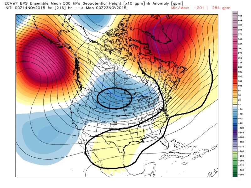
" />The result of this will be the beating on the SE ridge. Up until now the SE ridge has flared up with avengence, hence the warmest current Nov relative to avgs on record. However just look at how the EPS model slowly corrects itslf over time. The key to this is the strong positive heights up into the GOA. This will pour arctic air into N America. Remember climatology will still lead to some moderation as it infiltrates the CONUS and bleeds east.
All images are depicting the 00z Nov 23rd time frame compliments of the Euro ensembles. Pay particular attention to how over the last two days the negative heights slowly begin to shift east, and the positive heights along the E coast are slowly beaten back.
Here is the 12z Nov 13th run:
 " />
" />00z Nov14th run:
 " />
" />12z Nov 14th:
 " />
" />And last nights 00z:
 " />
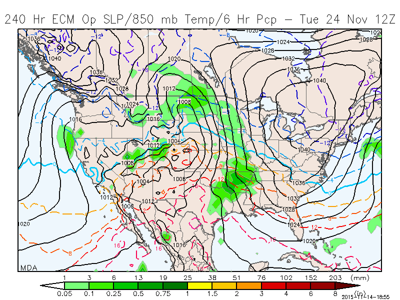
" />If the -EPO cont to hold strong on modeling I expect the models to cont to correct the center of the trough east, ultimately centering the trough over the GL. This could lead to the potential for a system to develop off the coast between the 23rd and 28th time frame.
The 12z Nov 25th time frame seems to be evolving the same way.
 " />
" /> " />
" /> " />
" /> " />
" />I DO NOT BELIEVE THIS LOCKS US INTO WINTER, BUT WILL CERTAINLY MAKE FOR AN INTERESTING TIME FRAME WITH THE POTENTIAL FOR SOME WHITE STUFF IN AND AROUND THE NORTH EAST.
_________________
"In weather and in life, there's no winning and losing; there's only winning and learning."
WINTER 2012/2013 TOTALS 43.65"WINTER 2017/2018 TOTALS 62.85" WINTER 2022/2023 TOTALS 4.9"
WINTER 2013/2014 TOTALS 64.85"WINTER 2018/2019 TOTALS 14.25" WINTER 2023/2024 TOTALS 13.1"
WINTER 2014/2015 TOTALS 71.20"WINTER 2019/2020 TOTALS 6.35"
WINTER 2015/2016 TOTALS 35.00"WINTER 2020/2021 TOTALS 37.75"
WINTER 2016/2017 TOTALS 42.25"WINTER 2021/2022 TOTALS 31.65"
sroc4- Admin
- Posts : 8331
Reputation : 301
Join date : 2013-01-07
Location : Wading River, LI
Re: Long Range Thread 8.0
![]() by Snow88 Sun Nov 15, 2015 9:14 am
by Snow88 Sun Nov 15, 2015 9:14 am
Snow88- Senior Enthusiast
- Posts : 2193
Reputation : 4
Join date : 2013-01-09
Age : 35
Location : Brooklyn, NY
Re: Long Range Thread 8.0
![]() by amugs Sun Nov 15, 2015 3:57 pm
by amugs Sun Nov 15, 2015 3:57 pm
http://www.bluehill.org/BHO201516WINTER.pdf
_________________
Mugs
AKA:King: Snow Weenie
Self Proclaimed
WINTER 2014-15 : 55.12" +.02 for 6 coatings (avg. 35")
WINTER 2015-16 Total - 29.8" (Avg 35")
WINTER 2016-17 : 39.5" so far
amugs- Advanced Forecaster - Mod
- Posts : 15093
Reputation : 213
Join date : 2013-01-07
Age : 54
Location : Hillsdale,NJ
Re: Long Range Thread 8.0
![]() by amugs Sun Nov 15, 2015 7:07 pm
by amugs Sun Nov 15, 2015 7:07 pm
Winter Outlook here
http://www.lightinthestorm.com/archives/922
_________________
Mugs
AKA:King: Snow Weenie
Self Proclaimed
WINTER 2014-15 : 55.12" +.02 for 6 coatings (avg. 35")
WINTER 2015-16 Total - 29.8" (Avg 35")
WINTER 2016-17 : 39.5" so far
amugs- Advanced Forecaster - Mod
- Posts : 15093
Reputation : 213
Join date : 2013-01-07
Age : 54
Location : Hillsdale,NJ
Re: Long Range Thread 8.0
![]() by Frank_Wx Sun Nov 15, 2015 9:19 pm
by Frank_Wx Sun Nov 15, 2015 9:19 pm
amugs wrote:From one of our own - Isotherm. Very technical outlook and write up especially on the qbo section, whew my head is spinning but looking good - winter that is !
Winter Outlook here
http://www.lightinthestorm.com/archives/922
This is probably the best winter outlook Iv'e read this season. He goes into a level of detail not many forecasters dare touch on.
_________________
_______________________________________________________________________________________________________
CLICK HERE to view NJ Strong Snowstorm Classifications
Frank_Wx- Godzilla Seeker
- Posts : 21305
Reputation : 328
Join date : 2013-01-05
Age : 31
Location : Jersey City, NJ -
Re: Long Range Thread 8.0
![]() by sroc4 Mon Nov 16, 2015 7:01 am
by sroc4 Mon Nov 16, 2015 7:01 am
Frank_Wx wrote:amugs wrote:From one of our own - Isotherm. Very technical outlook and write up especially on the qbo section, whew my head is spinning but looking good - winter that is !
Winter Outlook here
http://www.lightinthestorm.com/archives/922
This is probably the best winter outlook Iv'e read this season. He goes into a level of detail not many forecasters dare touch on.
Wow agreed. How cool is the idea of mountain torque? Great write up.
_________________
"In weather and in life, there's no winning and losing; there's only winning and learning."
WINTER 2012/2013 TOTALS 43.65"WINTER 2017/2018 TOTALS 62.85" WINTER 2022/2023 TOTALS 4.9"
WINTER 2013/2014 TOTALS 64.85"WINTER 2018/2019 TOTALS 14.25" WINTER 2023/2024 TOTALS 13.1"
WINTER 2014/2015 TOTALS 71.20"WINTER 2019/2020 TOTALS 6.35"
WINTER 2015/2016 TOTALS 35.00"WINTER 2020/2021 TOTALS 37.75"
WINTER 2016/2017 TOTALS 42.25"WINTER 2021/2022 TOTALS 31.65"
sroc4- Admin
- Posts : 8331
Reputation : 301
Join date : 2013-01-07
Location : Wading River, LI
Re: Long Range Thread 8.0
![]() by nutleyblizzard Mon Nov 16, 2015 10:35 am
by nutleyblizzard Mon Nov 16, 2015 10:35 am
nutleyblizzard- Senior Enthusiast
- Posts : 1952
Reputation : 41
Join date : 2014-01-30
Age : 58
Location : Nutley, new jersey
Re: Long Range Thread 8.0
![]() by Frank_Wx Mon Nov 16, 2015 11:20 am
by Frank_Wx Mon Nov 16, 2015 11:20 am
_________________
_______________________________________________________________________________________________________
CLICK HERE to view NJ Strong Snowstorm Classifications
Frank_Wx- Godzilla Seeker
- Posts : 21305
Reputation : 328
Join date : 2013-01-05
Age : 31
Location : Jersey City, NJ -
Page 39 of 40 • 1 ... 21 ... 38, 39, 40 ![]()
|
|
|