
 Search
Hybrid / Sub-Tropical Storm Possible Sunday-Monday (UNCERTAINTY)
Page 30 of 40 •  1 ... 16 ... 29, 30, 31 ... 35 ... 40
 ![]()
Re: Hybrid / Sub-Tropical Storm Possible Sunday-Monday (UNCERTAINTY)
![]() by nutleyblizzard Wed Sep 30, 2015 2:26 pm
by nutleyblizzard Wed Sep 30, 2015 2:26 pm
nutleyblizzard- Senior Enthusiast

- Posts : 1952
Join date : 2014-01-30
Re: Hybrid / Sub-Tropical Storm Possible Sunday-Monday (UNCERTAINTY)
![]() by Frank_Wx Wed Sep 30, 2015 2:26 pm
by Frank_Wx Wed Sep 30, 2015 2:26 pm
Frank_Wx- Godzilla Seeker

- Posts : 21305
Join date : 2013-01-05 -

Re: Hybrid / Sub-Tropical Storm Possible Sunday-Monday (UNCERTAINTY)
![]() by rb924119 Wed Sep 30, 2015 2:32 pm
by rb924119 Wed Sep 30, 2015 2:32 pm
rb924119- Meteorologist

- Posts : 6890
Reputation : 194
Join date : 2013-02-06
Age : 32
Location : Greentown, Pa
Re: Hybrid / Sub-Tropical Storm Possible Sunday-Monday (UNCERTAINTY)
![]() by rb924119 Wed Sep 30, 2015 2:35 pm
by rb924119 Wed Sep 30, 2015 2:35 pm
rb924119- Meteorologist
- Posts : 6890
Reputation : 194
Join date : 2013-02-06
Age : 32
Location : Greentown, Pa
Re: Hybrid / Sub-Tropical Storm Possible Sunday-Monday (UNCERTAINTY)
![]() by meatsanwch Wed Sep 30, 2015 2:37 pm
by meatsanwch Wed Sep 30, 2015 2:37 pm
syosnow94 wrote:I mean this is nuts. I'm not well versed on all the scientific mumbo jumbo, but for models to be 180 degrees opposite on their forecast solutions and then to not even be able to have the real time data in them is ridiculous. What's the point of even following them?
Youre starting to catch on
meatsanwch- Posts : 11
Reputation : 0
Join date : 2014-01-02
Re: Hybrid / Sub-Tropical Storm Possible Sunday-Monday (UNCERTAINTY)
![]() by Math23x7 Wed Sep 30, 2015 2:56 pm
by Math23x7 Wed Sep 30, 2015 2:56 pm
Math23x7- Wx Statistician Guru

- Posts : 2379
Reputation : 68
Join date : 2013-01-08
Re: Hybrid / Sub-Tropical Storm Possible Sunday-Monday (UNCERTAINTY)
![]() by skinsfan1177 Wed Sep 30, 2015 3:14 pm
by skinsfan1177 Wed Sep 30, 2015 3:14 pm

skinsfan1177- Senior Enthusiast
- Posts : 4485
Reputation : 35
Join date : 2013-01-07
Age : 46
Location : Point Pleasant Boro
Re: Hybrid / Sub-Tropical Storm Possible Sunday-Monday (UNCERTAINTY)
![]() by weatherwatchermom Wed Sep 30, 2015 3:19 pm
by weatherwatchermom Wed Sep 30, 2015 3:19 pm
amugs wrote:Abba701 wrote:If this would make landfall in the same area as sandy or north would it cause a huge surge again?
Basically yes - the topography of the Jersey Shoreline and NYC, and LI shores will propagate (add) to the intensity of the surge. Could be a low end 2' or a 4' moderate surge, always remember this is in height and then add the waves on top of that that could be from 8' swells to 15' + depending on some variables.
Sandy brought a 15 foot surge to us off the Raritan Bay....hx-we have flood gates that are designed to handle up to 14 feet of water...the engineers never really knew if they could do the job...they did thank goodness and we had a 15 foot surge the gate operators told us...so hopefully nothing like that again! everything to the left of us destroyed(that Iconic House that was split in half that was on the magazine covers is a 10 minute walk from my house and) and everything to the right was destroyed.

weatherwatchermom- Senior Enthusiast
- Posts : 3749
Reputation : 77
Join date : 2014-11-25
Age : 60
Location : Hazlet Township, NJ
Re: Hybrid / Sub-Tropical Storm Possible Sunday-Monday (UNCERTAINTY)
![]() by jmanley32 Wed Sep 30, 2015 3:23 pm
by jmanley32 Wed Sep 30, 2015 3:23 pm

jmanley32- Senior Enthusiast
- Posts : 20516
Reputation : 108
Join date : 2013-12-12
Age : 42
Location : Yonkers, NY
Re: Hybrid / Sub-Tropical Storm Possible Sunday-Monday (UNCERTAINTY)
![]() by jmanley32 Wed Sep 30, 2015 3:24 pm
by jmanley32 Wed Sep 30, 2015 3:24 pm
jmanley32- Senior Enthusiast
- Posts : 20516
Reputation : 108
Join date : 2013-12-12
Age : 42
Location : Yonkers, NY
Re: Hybrid / Sub-Tropical Storm Possible Sunday-Monday (UNCERTAINTY)
![]() by NjWeatherGuy Wed Sep 30, 2015 3:28 pm
by NjWeatherGuy Wed Sep 30, 2015 3:28 pm

NjWeatherGuy- Advanced Forecaster

- Posts : 4100
Reputation : 28
Join date : 2013-01-06
Location : Belle Mead, NJ
Re: Hybrid / Sub-Tropical Storm Possible Sunday-Monday (UNCERTAINTY)
![]() by Frank_Wx Wed Sep 30, 2015 3:31 pm
by Frank_Wx Wed Sep 30, 2015 3:31 pm

_________________
_______________________________________________________________________________________________________
CLICK HERE to view NJ Strong Snowstorm Classifications

Frank_Wx- Godzilla Seeker
- Posts : 21305
Reputation : 328
Join date : 2013-01-05
Age : 31
Location : Jersey City, NJ -
Re: Hybrid / Sub-Tropical Storm Possible Sunday-Monday (UNCERTAINTY)
![]() by Frank_Wx Wed Sep 30, 2015 3:32 pm
by Frank_Wx Wed Sep 30, 2015 3:32 pm
_________________
_______________________________________________________________________________________________________
CLICK HERE to view NJ Strong Snowstorm Classifications
Frank_Wx- Godzilla Seeker
- Posts : 21305
Reputation : 328
Join date : 2013-01-05
Age : 31
Location : Jersey City, NJ -
Re: Hybrid / Sub-Tropical Storm Possible Sunday-Monday (UNCERTAINTY)
![]() by jmanley32 Wed Sep 30, 2015 3:39 pm
by jmanley32 Wed Sep 30, 2015 3:39 pm
jmanley32- Senior Enthusiast
- Posts : 20516
Reputation : 108
Join date : 2013-12-12
Age : 42
Location : Yonkers, NY
Re: Hybrid / Sub-Tropical Storm Possible Sunday-Monday (UNCERTAINTY)
![]() by aiannone Wed Sep 30, 2015 3:42 pm
by aiannone Wed Sep 30, 2015 3:42 pm
_________________
-Alex Iannone-

aiannone- Senior Enthusiast - Mod

- Posts : 4814
Reputation : 92
Join date : 2013-01-07
Location : Saint James, LI (Northwest Suffolk Co.)
Re: Hybrid / Sub-Tropical Storm Possible Sunday-Monday (UNCERTAINTY)
![]() by jmanley32 Wed Sep 30, 2015 4:01 pm
by jmanley32 Wed Sep 30, 2015 4:01 pm
aiannone wrote:JMA says i'll flood you for days.
Flood who? From what I have seen rain has backed off big time, I wanted at least some kinda storm didn't have be crazy, looking less likely then again we are going by only a day or so of model runs with a hit so far south. Not even a day. Like Alex said we are far from the truth, even if it is what it shows its still 5 days away unless he speeds up. Eye is poking through, still an amazing system to watch, way exceeded intensity forecasts from when was just invest.
jmanley32- Senior Enthusiast
- Posts : 20516
Reputation : 108
Join date : 2013-12-12
Age : 42
Location : Yonkers, NY
Re: Hybrid / Sub-Tropical Storm Possible Sunday-Monday (UNCERTAINTY)
![]() by Frank_Wx Wed Sep 30, 2015 4:06 pm
by Frank_Wx Wed Sep 30, 2015 4:06 pm
We will have to give this another full day to get a better idea.
_________________
_______________________________________________________________________________________________________
CLICK HERE to view NJ Strong Snowstorm Classifications
Frank_Wx- Godzilla Seeker
- Posts : 21305
Reputation : 328
Join date : 2013-01-05
Age : 31
Location : Jersey City, NJ -
Re: Hybrid / Sub-Tropical Storm Possible Sunday-Monday (UNCERTAINTY)
![]() by aiannone Wed Sep 30, 2015 4:16 pm
by aiannone Wed Sep 30, 2015 4:16 pm
jmanley32 wrote:aiannone wrote:JMA says i'll flood you for days.
Flood who? From what I have seen rain has backed off big time, I wanted at least some kinda storm didn't have be crazy, looking less likely then again we are going by only a day or so of model runs with a hit so far south. Not even a day. Like Alex said we are far from the truth, even if it is what it shows its still 5 days away unless he speeds up. Eye is poking through, still an amazing system to watch, way exceeded intensity forecasts from when was just invest.
The SE coast will flood for days. sits there for several days. not us
_________________
-Alex Iannone-
aiannone- Senior Enthusiast - Mod
- Posts : 4814
Reputation : 92
Join date : 2013-01-07
Location : Saint James, LI (Northwest Suffolk Co.)
Re: Hybrid / Sub-Tropical Storm Possible Sunday-Monday (UNCERTAINTY)
![]() by aiannone Wed Sep 30, 2015 4:20 pm
by aiannone Wed Sep 30, 2015 4:20 pm
_________________
-Alex Iannone-
aiannone- Senior Enthusiast - Mod
- Posts : 4814
Reputation : 92
Join date : 2013-01-07
Location : Saint James, LI (Northwest Suffolk Co.)
Re: Hybrid / Sub-Tropical Storm Possible Sunday-Monday (UNCERTAINTY)
![]() by skinsfan1177 Wed Sep 30, 2015 4:22 pm
by skinsfan1177 Wed Sep 30, 2015 4:22 pm
skinsfan1177- Senior Enthusiast
- Posts : 4485
Reputation : 35
Join date : 2013-01-07
Age : 46
Location : Point Pleasant Boro
Re: Hybrid / Sub-Tropical Storm Possible Sunday-Monday (UNCERTAINTY)
![]() by jmanley32 Wed Sep 30, 2015 4:23 pm
by jmanley32 Wed Sep 30, 2015 4:23 pm
Frank_Wx wrote:The EURO Ens offer no help. Some OTS, some re-loop back to Mid-Atlantic, some south into carolina's.
We will have to give this another full day to get a better idea.
I just reviewed all 51 stamps and its a mess as you said, timing all over place, track all over, intensity for most part only think that is somewhat consistent. Something has to crack at some pt. Either Euro is king like with Sandy or a great failure to the other models. I guess I will be up again tonight lol, 5pm full update within 40 min or less, lets see if NHC changes cone intensity etc.
jmanley32- Senior Enthusiast
- Posts : 20516
Reputation : 108
Join date : 2013-12-12
Age : 42
Location : Yonkers, NY
Re: Hybrid / Sub-Tropical Storm Possible Sunday-Monday (UNCERTAINTY)
![]() by jmanley32 Wed Sep 30, 2015 4:24 pm
by jmanley32 Wed Sep 30, 2015 4:24 pm
aiannone wrote:
I like him : )
jmanley32- Senior Enthusiast
- Posts : 20516
Reputation : 108
Join date : 2013-12-12
Age : 42
Location : Yonkers, NY
Re: Hybrid / Sub-Tropical Storm Possible Sunday-Monday (UNCERTAINTY)
![]() by RJB8525 Wed Sep 30, 2015 4:25 pm
by RJB8525 Wed Sep 30, 2015 4:25 pm

RJB8525- Senior Enthusiast
- Posts : 1994
Reputation : 28
Join date : 2013-02-06
Age : 38
Location : Hackettstown, NJ
Re: Hybrid / Sub-Tropical Storm Possible Sunday-Monday (UNCERTAINTY)
![]() by jmanley32 Wed Sep 30, 2015 4:34 pm
by jmanley32 Wed Sep 30, 2015 4:34 pm
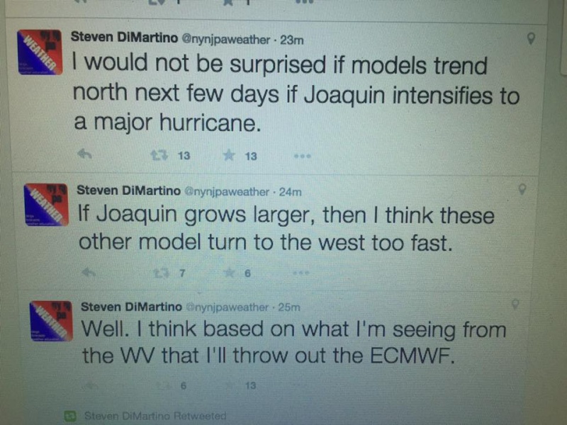
Steven DiMartino Retweeted
frank dana @fdana728 · 38m38 minutes ago
@nynjpaweather I have a cousin at the NHC. He said the exact same thing. He thinks the Delmarva to S Jersey
jmanley32- Senior Enthusiast
- Posts : 20516
Reputation : 108
Join date : 2013-12-12
Age : 42
Location : Yonkers, NY
Re: Hybrid / Sub-Tropical Storm Possible Sunday-Monday (UNCERTAINTY)
![]() by Abba701 Wed Sep 30, 2015 4:43 pm
by Abba701 Wed Sep 30, 2015 4:43 pm
Abba701- Posts : 328
Reputation : 0
Join date : 2013-01-14
Re: Hybrid / Sub-Tropical Storm Possible Sunday-Monday (UNCERTAINTY)
![]() by aiannone Wed Sep 30, 2015 4:46 pm
by aiannone Wed Sep 30, 2015 4:46 pm
_________________
-Alex Iannone-
aiannone- Senior Enthusiast - Mod
- Posts : 4814
Reputation : 92
Join date : 2013-01-07
Location : Saint James, LI (Northwest Suffolk Co.)
Re: Hybrid / Sub-Tropical Storm Possible Sunday-Monday (UNCERTAINTY)
![]() by Frank_Wx Wed Sep 30, 2015 4:47 pm
by Frank_Wx Wed Sep 30, 2015 4:47 pm
Hello (insert name),
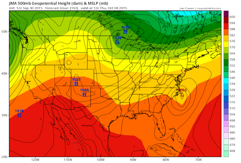
Yesterday's model runs were painting a much more ominous picture than today's runs. Today, the models believe the Hurricane will either stay out to sea or make landfall over North Carolina. The majority have Joaquin making landfall in North Carolina. Given the size of this storm, this will have an impact on Washington DC.
Here are the scenarios:
Scenario A
Joaquin makes landfall on Virginia Beach or the Delmarva. This is what the models were showing yesterday. Obviously the worst case scenario that would bring Sandy-like impacts from Washington DC all the way up to New York City. As of today, there is NO support from the models of this happening. If Joaquin weakens over the Atlantic he has a better chance of taking this path. If he remains strong, he will track elsewhere (I would explain why but I do not think that matters to you haha).
Scenario B
Joaquin makes landfall on North Carolina. Today, this seems to be the consensus with the weather models. However, the National Hurricane Center still has the official track heading to VA Beach / DE. Even if the Hurricane took this track, Washington DC would still get flooding rains and high winds due to the sheer size of this storm. This track will only limit impact for the Philadelphia and NYC Metro regions, but DC would still get hit pretty hard with probably 5-10 inches of rain and gusts between 40-60 mph. Since the ground is already saturated and the trees still have all their leaves on them, sustained winds of that force over a 10 hour period would lead to widespread power outages.
Scenario C
Joaquin slows down or takes a longer path to get here and it becomes more of a mid-week system rather than a Sunday event.
Scenario D
Joaquin heads out to sea bringing little to no impact to the area (besides beach erosion and high waves along the immediate coast).
There is more to the forecast but I do not want to bore you with the details. If I had to choose a scenario, I would pick B or C. I cannot say anything definitively at this time since there is so much uncertainty and inconsistency with the models. Tomorrow, I can give you another update and tell you which "Scenario" the models are leaning toward.
I hope this helps.
_________________
_______________________________________________________________________________________________________
CLICK HERE to view NJ Strong Snowstorm Classifications
Frank_Wx- Godzilla Seeker
- Posts : 21305
Reputation : 328
Join date : 2013-01-05
Age : 31
Location : Jersey City, NJ -
Sponsored content
Page 30 of 40 • 1 ... 16 ... 29, 30, 31 ... 35 ... 40 ![]()
|
|
|