
 Search
Hybrid / Sub-Tropical Storm Possible Sunday-Monday (UNCERTAINTY)
Page 40 of 40 •  1 ... 21 ... 38, 39, 40
Re: Hybrid / Sub-Tropical Storm Possible Sunday-Monday (UNCERTAINTY)
![]() by skinsfan1177 Thu Oct 01, 2015 4:58 am
by skinsfan1177 Thu Oct 01, 2015 4:58 am
skinsfan1177- Senior Enthusiast

- Posts : 4485
Join date : 2013-01-07
Re: Hybrid / Sub-Tropical Storm Possible Sunday-Monday (UNCERTAINTY)
![]() by Frank_Wx Thu Oct 01, 2015 6:06 am
by Frank_Wx Thu Oct 01, 2015 6:06 am
Frank_Wx- Godzilla Seeker

- Posts : 21305
Join date : 2013-01-05 -

Re: Hybrid / Sub-Tropical Storm Possible Sunday-Monday (UNCERTAINTY)
![]() by skinsfan1177 Thu Oct 01, 2015 6:13 am
by skinsfan1177 Thu Oct 01, 2015 6:13 am

skinsfan1177- Senior Enthusiast
- Posts : 4485
Reputation : 35
Join date : 2013-01-07
Age : 46
Location : Point Pleasant Boro
Re: Hybrid / Sub-Tropical Storm Possible Sunday-Monday (UNCERTAINTY)
![]() by jmanley32 Thu Oct 01, 2015 6:24 am
by jmanley32 Thu Oct 01, 2015 6:24 am

jmanley32- Senior Enthusiast
- Posts : 20513
Reputation : 108
Join date : 2013-12-12
Age : 42
Location : Yonkers, NY
Re: Hybrid / Sub-Tropical Storm Possible Sunday-Monday (UNCERTAINTY)
![]() by skinsfan1177 Thu Oct 01, 2015 6:31 am
by skinsfan1177 Thu Oct 01, 2015 6:31 am
skinsfan1177- Senior Enthusiast
- Posts : 4485
Reputation : 35
Join date : 2013-01-07
Age : 46
Location : Point Pleasant Boro
Re: Hybrid / Sub-Tropical Storm Possible Sunday-Monday (UNCERTAINTY)
![]() by Tzvi732 Thu Oct 01, 2015 6:34 am
by Tzvi732 Thu Oct 01, 2015 6:34 am
Tzvi732- Posts : 7
Reputation : 0
Join date : 2015-09-30
Location : lakewood nj
Re: Hybrid / Sub-Tropical Storm Possible Sunday-Monday (UNCERTAINTY)
![]() by Math23x7 Thu Oct 01, 2015 7:07 am
by Math23x7 Thu Oct 01, 2015 7:07 am
Math23x7- Wx Statistician Guru

- Posts : 2379
Reputation : 68
Join date : 2013-01-08
Re: Hybrid / Sub-Tropical Storm Possible Sunday-Monday (UNCERTAINTY)
![]() by Abba701 Thu Oct 01, 2015 7:21 am
by Abba701 Thu Oct 01, 2015 7:21 am
Tzvi732 wrote:Agreed this is so far out no way we can believe a track yet. Although I think it's going out to see.
Agreed.as long as the trends continue.And even if not in no way can we say it's a sandy like the 0z GFS showed.
Abba701- Posts : 328
Reputation : 0
Join date : 2013-01-14
Re: Hybrid / Sub-Tropical Storm Possible Sunday-Monday (UNCERTAINTY)
![]() by SoulSingMG Thu Oct 01, 2015 7:25 am
by SoulSingMG Thu Oct 01, 2015 7:25 am

SoulSingMG- Senior Enthusiast
- Posts : 2853
Reputation : 74
Join date : 2013-12-11
Location : Long Island City, NY
Re: Hybrid / Sub-Tropical Storm Possible Sunday-Monday (UNCERTAINTY)
![]() by NjWeatherGuy Thu Oct 01, 2015 7:27 am
by NjWeatherGuy Thu Oct 01, 2015 7:27 am

NjWeatherGuy- Advanced Forecaster

- Posts : 4100
Reputation : 28
Join date : 2013-01-06
Location : Belle Mead, NJ
Re: Hybrid / Sub-Tropical Storm Possible Sunday-Monday (UNCERTAINTY)
![]() by meatsanwch Thu Oct 01, 2015 7:31 am
by meatsanwch Thu Oct 01, 2015 7:31 am
NjWeatherGuy wrote:Hearing theyre expecting a strong east trend to euro today, seriously these models are so bad they shouldnt go past 3 days, what the hells the point...
You're starting to catch on
meatsanwch- Posts : 11
Reputation : 0
Join date : 2014-01-02
Re: Hybrid / Sub-Tropical Storm Possible Sunday-Monday (UNCERTAINTY)
![]() by rb924119 Thu Oct 01, 2015 8:00 am
by rb924119 Thu Oct 01, 2015 8:00 am
The two images below are off the 500 hPa spaghettis, 00z followed by 06z for the same time.


Look at the difference in how they handle the trough. In the 00z suite, the trough has yet to close off, which allows it to continue to dig southeastward. Because it is still digging, there is enough of an interaction with Joaquin to start brining it westward BEFORE the trough closes off.
In 06z, the trough is already completely closed off. Why is this important? When a trough closes off, it means that it has reached maturity; in essence, it has dug as far south as it ever will, and it will begin to weaken after this point, since there is no more energy being fed into it from the mid-latitude jet. Because of this, the trough has drastically slowed its southeastward progression, and is instead losing its ability to capture Joaquin. As a result, the two systems remain completely separate, and Joaquin is allowed to recurve like it normally would. If this does end up to be the case, where H5 closes off early, I think we'll be fine. Just my opinion.
Last edited by rb924119 on Thu Oct 01, 2015 8:02 am; edited 1 time in total
rb924119- Meteorologist

- Posts : 6889
Reputation : 194
Join date : 2013-02-06
Age : 32
Location : Greentown, Pa
Re: Hybrid / Sub-Tropical Storm Possible Sunday-Monday (UNCERTAINTY)
![]() by sroc4 Thu Oct 01, 2015 8:02 am
by sroc4 Thu Oct 01, 2015 8:02 am
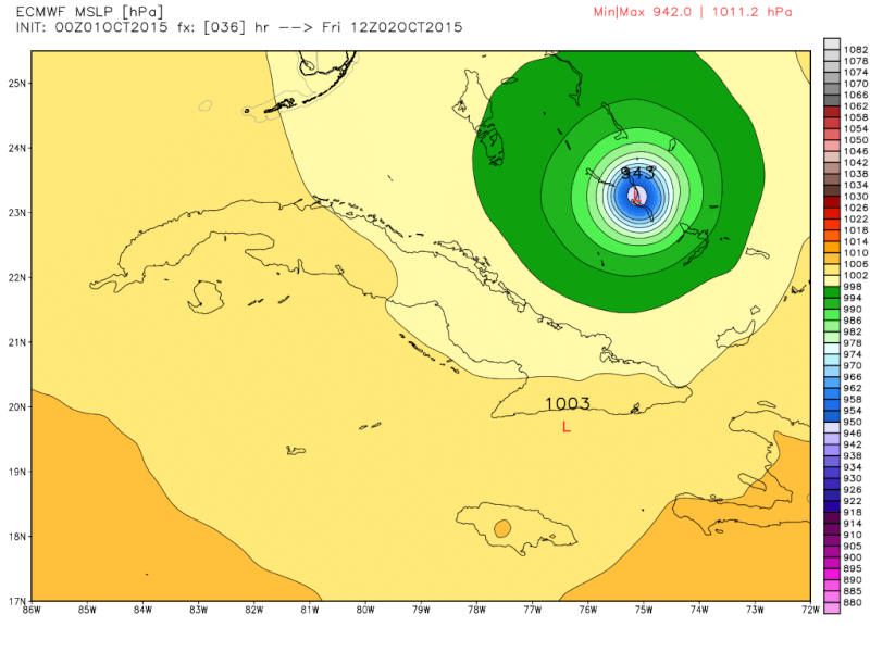
Current position is 23.4N and 73.7W


By midday tomorrow the GFS and the Euro have him centered differently.
 " />
" /> " />
" />When looking at the various steering layers one has to consider the intensity of a tropical system to know how high up in the atmosphere the steering layers will influence the direction of the tropical system. For example. Lets say we have a man standing 5' tall(ManA), vs a man standing 6' tall(ManB). In order for these two men to move we have individuals pushing them from behind at different levels. If we have 3 individuals independantly pushing both man A and Man B at 4ft and at 5ft both men will be influenced by those forces; however, if a third individual is also pushing at 6ft only the man who is 6ft tall will feel its influence because the man that is only 5ft tall is underneath the man pushing at 6ft. My point here is that the 5' man would be like a Trop storm or Cat1cane; whereas, the 6' man is analogous to say a Cat3 Cane because its convection is taller and has a much larger diameter. So where am I going with this?
Well after analyzing the steering layers at lower levels If you look at this map you can see the lane where we would expect to see Joaquin start to get pulled N today given the lower layer wind vectors. But on the models, esp Euro we actually see a shift south over the next 24hrs.
 " />
" />HOWEVER, because Joaquin is so strong he reaches much higher up in the atmosphere so we have to look at the steering at those levels as well. Take a look here:
 " />
" />The current water vapor image shows this upper level map in real time very well

http://weather.cod.edu/satrad/?type=s_atlantic-wv-0-24&checked=&prodDim=100&overDim=100
So as you can see because Joaquin is at least 6'tall it is being influence by the wind vectors much higher into the atmosphere. The next 24-36hrs will be key. If you look at H5 for both GFS and Euro you will notice that they both have the placement of the H5 trough EXACTLY in the same position. Similarly the Omega block in Central Canada, the ULL in eastern canada, and the NW Atlantic ridge are all pretty much identical on both models. Again the position of Joaquin over the next 24hrs will be key to its interaction with the H5 cutoff Low that will be in the SE CONUS:
Edit: after reading Rb's write up above the exact timing and how far the H5 trough digs and cuts off relative to the positioning of Joaquin will play key roles.
Last edited by sroc4 on Thu Oct 01, 2015 8:07 am; edited 1 time in total
_________________
"In weather and in life, there's no winning and losing; there's only winning and learning."
WINTER 2012/2013 TOTALS 43.65"WINTER 2017/2018 TOTALS 62.85" WINTER 2022/2023 TOTALS 4.9"
WINTER 2013/2014 TOTALS 64.85"WINTER 2018/2019 TOTALS 14.25" WINTER 2023/2024 TOTALS 13.1"
WINTER 2014/2015 TOTALS 71.20"WINTER 2019/2020 TOTALS 6.35"
WINTER 2015/2016 TOTALS 35.00"WINTER 2020/2021 TOTALS 37.75"
WINTER 2016/2017 TOTALS 42.25"WINTER 2021/2022 TOTALS 31.65"

sroc4- Admin
- Posts : 8331
Reputation : 301
Join date : 2013-01-07
Location : Wading River, LI
Re: Hybrid / Sub-Tropical Storm Possible Sunday-Monday (UNCERTAINTY)
![]() by Taffy Thu Oct 01, 2015 8:05 am
by Taffy Thu Oct 01, 2015 8:05 am

Taffy- Pro Enthusiast

- Posts : 530
Reputation : 19
Join date : 2013-10-06
Location : Hopkinton, MA
Re: Hybrid / Sub-Tropical Storm Possible Sunday-Monday (UNCERTAINTY)
![]() by Frank_Wx Thu Oct 01, 2015 8:06 am
by Frank_Wx Thu Oct 01, 2015 8:06 am
The 00z EURO Ensembles were mostly out to sea

_________________
_______________________________________________________________________________________________________
CLICK HERE to view NJ Strong Snowstorm Classifications

Frank_Wx- Godzilla Seeker
- Posts : 21305
Reputation : 328
Join date : 2013-01-05
Age : 31
Location : Jersey City, NJ -
Re: Hybrid / Sub-Tropical Storm Possible Sunday-Monday (UNCERTAINTY)
![]() by amugs Thu Oct 01, 2015 8:07 am
by amugs Thu Oct 01, 2015 8:07 am
DO NOT WRITE this off as i have been reading some posts on here. These meteorological beasts have and always will surprise in someway shape or form. Do not let your guard down on this just yet. Look at the trends yesterday - South and now they're saying east.
We have had a cone for landfall in 48 hours from NC to the Flemish Cap!

Model error at this range is ridiculous for these behemoths - like 300 -400 miles!
_________________
Mugs
AKA:King: Snow Weenie
Self Proclaimed
WINTER 2014-15 : 55.12" +.02 for 6 coatings (avg. 35")
WINTER 2015-16 Total - 29.8" (Avg 35")
WINTER 2016-17 : 39.5" so far

amugs- Advanced Forecaster - Mod

- Posts : 15093
Reputation : 213
Join date : 2013-01-07
Age : 54
Location : Hillsdale,NJ
Re: Hybrid / Sub-Tropical Storm Possible Sunday-Monday (UNCERTAINTY)
![]() by Frank_Wx Thu Oct 01, 2015 8:08 am
by Frank_Wx Thu Oct 01, 2015 8:08 am
_________________
_______________________________________________________________________________________________________
CLICK HERE to view NJ Strong Snowstorm Classifications
Frank_Wx- Godzilla Seeker
- Posts : 21305
Reputation : 328
Join date : 2013-01-05
Age : 31
Location : Jersey City, NJ -
Re: Hybrid / Sub-Tropical Storm Possible Sunday-Monday (UNCERTAINTY)
![]() by Frank_Wx Thu Oct 01, 2015 8:09 am
by Frank_Wx Thu Oct 01, 2015 8:09 am
-------
https://www.njstrongweatherforum.com/viewtopic.forum?t=569
-------
https://www.njstrongweatherforum.com/viewtopic.forum?t=572
_________________
_______________________________________________________________________________________________________
CLICK HERE to view NJ Strong Snowstorm Classifications
Frank_Wx- Godzilla Seeker
- Posts : 21305
Reputation : 328
Join date : 2013-01-05
Age : 31
Location : Jersey City, NJ -
Sponsored content
Page 40 of 40 • 1 ... 21 ... 38, 39, 40
|
|
|