
 Search
Hybrid / Sub-Tropical Storm Possible Sunday-Monday (UNCERTAINTY)
Page 1 of 40 • 1, 2, 3 ... 20 ... 40 ![]()

Hybrid / Sub-Tropical Storm Possible Sunday-Monday (UNCERTAINTY)
![]() by sroc4 Mon Sep 28, 2015 2:36 pm
by sroc4 Mon Sep 28, 2015 2:36 pm
rb924119 wrote:
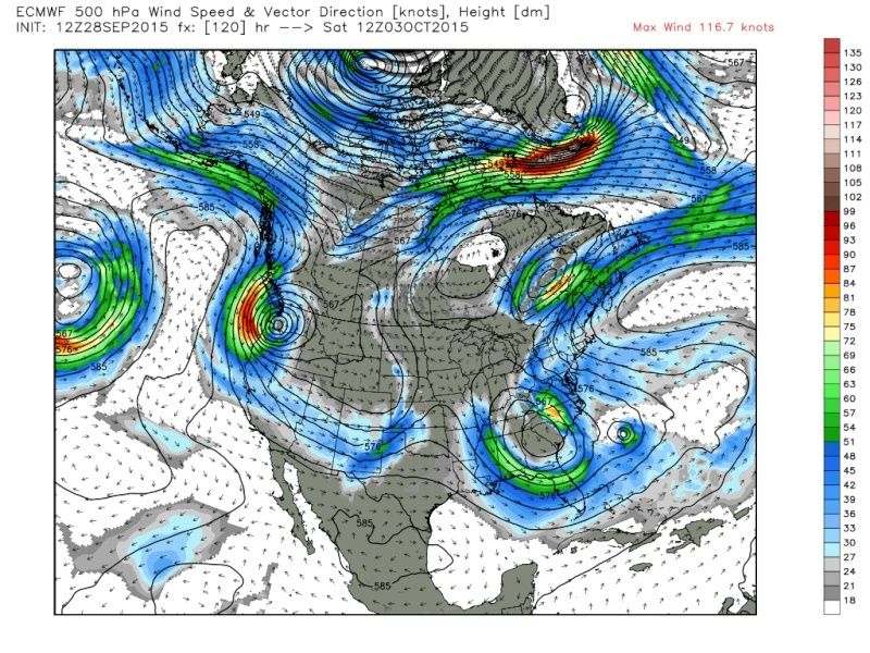
Not gonna lie, I don't like this one bit.

Look at the H5 set up. Yikes if its true
 " />
" />_________________
"In weather and in life, there's no winning and losing; there's only winning and learning."
WINTER 2012/2013 TOTALS 43.65"WINTER 2017/2018 TOTALS 62.85" WINTER 2022/2023 TOTALS 4.9"
WINTER 2013/2014 TOTALS 64.85"WINTER 2018/2019 TOTALS 14.25" WINTER 2023/2024 TOTALS 13.1"
WINTER 2014/2015 TOTALS 71.20"WINTER 2019/2020 TOTALS 6.35"
WINTER 2015/2016 TOTALS 35.00"WINTER 2020/2021 TOTALS 37.75"
WINTER 2016/2017 TOTALS 42.25"WINTER 2021/2022 TOTALS 31.65"

sroc4- Admin

- Posts : 8354
Reputation : 302
Join date : 2013-01-07
Location : Wading River, LI
Re: Hybrid / Sub-Tropical Storm Possible Sunday-Monday (UNCERTAINTY)
![]() by sroc4 Mon Sep 28, 2015 2:41 pm
by sroc4 Mon Sep 28, 2015 2:41 pm
_________________
"In weather and in life, there's no winning and losing; there's only winning and learning."
WINTER 2012/2013 TOTALS 43.65"WINTER 2017/2018 TOTALS 62.85" WINTER 2022/2023 TOTALS 4.9"
WINTER 2013/2014 TOTALS 64.85"WINTER 2018/2019 TOTALS 14.25" WINTER 2023/2024 TOTALS 13.1"
WINTER 2014/2015 TOTALS 71.20"WINTER 2019/2020 TOTALS 6.35"
WINTER 2015/2016 TOTALS 35.00"WINTER 2020/2021 TOTALS 37.75"
WINTER 2016/2017 TOTALS 42.25"WINTER 2021/2022 TOTALS 31.65"
sroc4- Admin
- Posts : 8354
Reputation : 302
Join date : 2013-01-07
Location : Wading River, LI
Re: Hybrid / Sub-Tropical Storm Possible Sunday-Monday (UNCERTAINTY)
![]() by jmanley32 Mon Sep 28, 2015 2:46 pm
by jmanley32 Mon Sep 28, 2015 2:46 pm
sroc4 wrote:Lets keep the discussions here guys and not clog up the other threads. If we need to we will seperate threads further.rb924119 wrote:
Not gonna lie, I don't like this one bit.
Look at the H5 set up. Yikes if its true
sroc can you kindly move my posts from sept. to here. They took me some time.

jmanley32- Senior Enthusiast

- Posts : 20535
Reputation : 108
Join date : 2013-12-12
Age : 43
Location : Yonkers, NY
Re: Hybrid / Sub-Tropical Storm Possible Sunday-Monday (UNCERTAINTY)
![]() by rb924119 Mon Sep 28, 2015 2:47 pm
by rb924119 Mon Sep 28, 2015 2:47 pm
Biggest differences right now between the GFS and the EURO are how they handle the amplification over our country. The GFS only partially wave-breaks the ridge over top of the phasing troughs, which allows extra trailing energy coming over the ridge to ball up and close off H5 over the lakes. It also doesn't develop the tropical entity nearly to the degree to the EURO does, which is also a large reason for the difference. The EURO not only completely wave-breaks the ridge over the top of the trough, but because the tropical system is significantly stronger as compared to the GFS, it is also infusing a lot more diabatic heating into the atmosphere to the north and east of it. This allows the ridge in the west-central Atlantic to build, and as the system intensifies and the ridge folds over the top part of the trough, it allows energy to consolidate more in the base of the trough, which further amplifies the ridge in the Atlantic. As this positive feedback process continues, the ridge in the Atlantic is also drawn to the point of breaking over the developing cut-off in the Southeast.
rb924119- Meteorologist

- Posts : 6928
Reputation : 194
Join date : 2013-02-06
Age : 32
Location : Greentown, Pa
Re: Hybrid / Sub-Tropical Storm Possible Sunday-Monday (UNCERTAINTY)
![]() by jmanley32 Mon Sep 28, 2015 2:49 pm
by jmanley32 Mon Sep 28, 2015 2:49 pm
rb924119 wrote:Sroc, can you move my last post from Banter? Sorry, I didn't realize you created a new thread already lol btw, did you ever see the write-up I posted?
rb, the Euro was crazy to say the least, totally diff run but still has two things a explosive system and one heck of a rain event through Monday, I think Euro ended with like 10-15 inches! I posted in other thread too didn't realize had a new thread.
jmanley32- Senior Enthusiast
- Posts : 20535
Reputation : 108
Join date : 2013-12-12
Age : 43
Location : Yonkers, NY
Re: Hybrid / Sub-Tropical Storm Possible Sunday-Monday (UNCERTAINTY)
![]() by jmanley32 Mon Sep 28, 2015 2:52 pm
by jmanley32 Mon Sep 28, 2015 2:52 pm
jmanley32- Senior Enthusiast
- Posts : 20535
Reputation : 108
Join date : 2013-12-12
Age : 43
Location : Yonkers, NY
Re: Hybrid / Sub-Tropical Storm Possible Sunday-Monday (UNCERTAINTY)
![]() by rb924119 Mon Sep 28, 2015 2:56 pm
by rb924119 Mon Sep 28, 2015 2:56 pm
rb924119- Meteorologist
- Posts : 6928
Reputation : 194
Join date : 2013-02-06
Age : 32
Location : Greentown, Pa
Re: Hybrid / Sub-Tropical Storm Possible Sunday-Monday (UNCERTAINTY)
![]() by sroc4 Mon Sep 28, 2015 2:57 pm
by sroc4 Mon Sep 28, 2015 2:57 pm
Is the turn further south bc the bloicking comes lower? RB you called a retrograde wow, this is getting kinda real even though its a week away, Sandy was nailed so we will just have to wait and see. You know what, technically this not September stuff, and should probably be in tropics section, I am totally confused where things should go right now, this might even be banter being its far off.

_________________
"In weather and in life, there's no winning and losing; there's only winning and learning."
WINTER 2012/2013 TOTALS 43.65"WINTER 2017/2018 TOTALS 62.85" WINTER 2022/2023 TOTALS 4.9"
WINTER 2013/2014 TOTALS 64.85"WINTER 2018/2019 TOTALS 14.25" WINTER 2023/2024 TOTALS 13.1"
WINTER 2014/2015 TOTALS 71.20"WINTER 2019/2020 TOTALS 6.35"
WINTER 2015/2016 TOTALS 35.00"WINTER 2020/2021 TOTALS 37.75"
WINTER 2016/2017 TOTALS 42.25"WINTER 2021/2022 TOTALS 31.65"
sroc4- Admin
- Posts : 8354
Reputation : 302
Join date : 2013-01-07
Location : Wading River, LI
Re: Hybrid / Sub-Tropical Storm Possible Sunday-Monday (UNCERTAINTY)
![]() by sroc4 Mon Sep 28, 2015 2:58 pm
by sroc4 Mon Sep 28, 2015 2:58 pm
_________________
"In weather and in life, there's no winning and losing; there's only winning and learning."
WINTER 2012/2013 TOTALS 43.65"WINTER 2017/2018 TOTALS 62.85" WINTER 2022/2023 TOTALS 4.9"
WINTER 2013/2014 TOTALS 64.85"WINTER 2018/2019 TOTALS 14.25" WINTER 2023/2024 TOTALS 13.1"
WINTER 2014/2015 TOTALS 71.20"WINTER 2019/2020 TOTALS 6.35"
WINTER 2015/2016 TOTALS 35.00"WINTER 2020/2021 TOTALS 37.75"
WINTER 2016/2017 TOTALS 42.25"WINTER 2021/2022 TOTALS 31.65"
sroc4- Admin
- Posts : 8354
Reputation : 302
Join date : 2013-01-07
Location : Wading River, LI
Re: Hybrid / Sub-Tropical Storm Possible Sunday-Monday (UNCERTAINTY)
![]() by amugs Mon Sep 28, 2015 2:58 pm
by amugs Mon Sep 28, 2015 2:58 pm

Deep upper level trough - YIKES!!

UKMET CMC and EURO basically on the same page - interesting to see - Jesus it feels like de ja vu 3 years later.
Jman winds will be battering the coast especially Southern Jersey for a couple of days from these model runs.
_________________
Mugs
AKA:King: Snow Weenie
Self Proclaimed
WINTER 2014-15 : 55.12" +.02 for 6 coatings (avg. 35")
WINTER 2015-16 Total - 29.8" (Avg 35")
WINTER 2016-17 : 39.5" so far

amugs- Advanced Forecaster - Mod

- Posts : 15095
Reputation : 213
Join date : 2013-01-07
Age : 54
Location : Hillsdale,NJ
Re: Hybrid / Sub-Tropical Storm Possible Sunday-Monday (UNCERTAINTY)
![]() by jmanley32 Mon Sep 28, 2015 2:59 pm
by jmanley32 Mon Sep 28, 2015 2:59 pm
rb924119 wrote:
Biggest differences right now between the GFS and the EURO are how they handle the amplification over our country. The GFS only partially wave-breaks the ridge over top of the phasing troughs, which allows extra trailing energy coming over the ridge to ball up and close off H5 over the lakes. It also doesn't develop the tropical entity nearly to the degree to the EURO does, which is also a large reason for the difference. The EURO not only completely wave-breaks the ridge over the top of the trough, but because the tropical system is significantly stronger as compared to the GFS, it is also infusing a lot more diabatic heating into the atmosphere to the north and east of it. This allows the ridge in the west-central Atlantic to build, and as the system intensifies and the ridge folds over the top part of the trough, it allows energy to consolidate more in the base of the trough, which further amplifies the ridge in the Atlantic. As this positive feedback process continues, the ridge in the Atlantic is also drawn to the point of breaking over the developing cut-off in the Southeast.
Only understood part of this but VA? I see we still get crazy rain and some wind verbatim on the Euro run but could this easily go back into the area as we go along? It is a huge difference in intensity that's for sure, which are u leaning towards at this juncture and is it really plausible we see a sandy 2, euro pretty much shows that but further south which can and probably will change, most these probably cannot be answered this early on. Do you think 2-3 days we be better informed? And as I learned from my tropical forums once the hurricane recon inputs their data and we get a named storm the models and everything else can change a lot.
jmanley32- Senior Enthusiast
- Posts : 20535
Reputation : 108
Join date : 2013-12-12
Age : 43
Location : Yonkers, NY
Re: Hybrid / Sub-Tropical Storm Possible Sunday-Monday (UNCERTAINTY)
![]() by jmanley32 Mon Sep 28, 2015 3:02 pm
by jmanley32 Mon Sep 28, 2015 3:02 pm
sroc4 wrote:No need to go on about this just yet. Will wait another 24hrs to look at additional runs and current observations.
sroc, got it 24 hrs hoping we know more, mugs yeah and depending on how far north it goes IF it does will determine how much I am affected. something tells me the euro too far south. But it even has a period of gusts past 50mph, and the total rain well...its boat worthy.
rb yes I know no hype, but from what you all have said this setup doesn't look good.
jmanley32- Senior Enthusiast
- Posts : 20535
Reputation : 108
Join date : 2013-12-12
Age : 43
Location : Yonkers, NY
Re: Hybrid / Sub-Tropical Storm Possible Sunday-Monday (UNCERTAINTY)
![]() by rb924119 Mon Sep 28, 2015 3:03 pm
by rb924119 Mon Sep 28, 2015 3:03 pm
500 hPa height anomalies hours leading up to landfall of Sandy:

12z EURO forecast height anomalies for hours leading up to landfall of "X":

UN........REAL
rb924119- Meteorologist
- Posts : 6928
Reputation : 194
Join date : 2013-02-06
Age : 32
Location : Greentown, Pa
Re: Hybrid / Sub-Tropical Storm Possible Sunday-Monday (UNCERTAINTY)
![]() by jmanley32 Mon Sep 28, 2015 3:07 pm
by jmanley32 Mon Sep 28, 2015 3:07 pm
rb924119 wrote:Mugs, you stole my thunder lol to supplement your recent post:
500 hPa height anomalies hours leading up to landfall of Sandy:
12z EURO forecast height anomalies for hours leading up to landfall of "X":
UN........REAL
If I understand what I am seeing here it looks almost identical, man oh man if we have a repeat of 2012 that 1:100 year event thing will be tossed forever. I always said though you never know. Not saying it will happen, as of now NHC only has a TS turning post tropical, but lets see what their update shows.
jmanley32- Senior Enthusiast
- Posts : 20535
Reputation : 108
Join date : 2013-12-12
Age : 43
Location : Yonkers, NY
Re: Hybrid / Sub-Tropical Storm Possible Sunday-Monday (UNCERTAINTY)
![]() by rb924119 Mon Sep 28, 2015 3:09 pm
by rb924119 Mon Sep 28, 2015 3:09 pm
rb924119- Meteorologist
- Posts : 6928
Reputation : 194
Join date : 2013-02-06
Age : 32
Location : Greentown, Pa
Re: Hybrid / Sub-Tropical Storm Possible Sunday-Monday (UNCERTAINTY)
![]() by amugs Mon Sep 28, 2015 3:12 pm
by amugs Mon Sep 28, 2015 3:12 pm
rb924119 wrote:Mugs, you stole my thunder lol to supplement your recent post:
500 hPa height anomalies hours leading up to landfall of Sandy:
12z EURO forecast height anomalies for hours leading up to landfall of "X":
UN........REAL
Brilliant minds think alike - I have to say in all honesty I was ehh when I looked at the 12Z model runs and then when I looked at these models I posted I almost fell off my chair - this as Frank would say speak volumes to me - the H5 set up. We will see by this time manana where things are at - if they show more of teh same then I start to call my friends at the beach and give them a heads up. Here is an even scarier thought - if this hit when we had the super moon - faget about it!
_________________
Mugs
AKA:King: Snow Weenie
Self Proclaimed
WINTER 2014-15 : 55.12" +.02 for 6 coatings (avg. 35")
WINTER 2015-16 Total - 29.8" (Avg 35")
WINTER 2016-17 : 39.5" so far
amugs- Advanced Forecaster - Mod
- Posts : 15095
Reputation : 213
Join date : 2013-01-07
Age : 54
Location : Hillsdale,NJ
Re: Hybrid / Sub-Tropical Storm Possible Sunday-Monday (UNCERTAINTY)
![]() by jmanley32 Mon Sep 28, 2015 3:13 pm
by jmanley32 Mon Sep 28, 2015 3:13 pm
rb924119 wrote:Only difference is the western ridge axis is further west. The problem is, the wavelengths of the two troughs to the east are so short that the western one, even though it does develop a "kicker", can't create one large enough to scoot the pinching off southern mid-level low fast enough to get ahead of the cyclone. Instead, it does it at the perfect time to suck this thing back in to the west. It actually creates a brief, very high amplitude, Omega block. This is nuts.
rb you may not be hyping it but you surely got my attention, do not understand the really technical stuff but all I know is im seeing deja vu as of right now and what are the odds of a setuop like this in 3 yrs apart.
jmanley32- Senior Enthusiast
- Posts : 20535
Reputation : 108
Join date : 2013-12-12
Age : 43
Location : Yonkers, NY
Re: Hybrid / Sub-Tropical Storm Possible Sunday-Monday (UNCERTAINTY)
![]() by jmanley32 Mon Sep 28, 2015 3:15 pm
by jmanley32 Mon Sep 28, 2015 3:15 pm
amugs wrote:rb924119 wrote:Mugs, you stole my thunder lol to supplement your recent post:
500 hPa height anomalies hours leading up to landfall of Sandy:
12z EURO forecast height anomalies for hours leading up to landfall of "X":
UN........REAL
Brilliant minds think alike - I have to say in all honesty I was ehh when I looked at the 12Z model runs and then when I looked at these models I posted I almost fell off my chair - this as Frank would say speak volumes to me - the H5 set up. We will see by this time manana where things are at - if they show more of teh same then I start to call my friends at the beach and give them a heads up. Here is an even scarier thought - if this hit when we had the super moon - faget about it!
True that, at least that's out of the picture...The Euro showed this huge too like near sandy size by windfield if you look at the gust map and precip map. It sure is nuts, and yes I understanding these particular maps a bit more which part is it that pulls this back west? And where is Frank I wanna hear his input though all yours are great too.
jmanley32- Senior Enthusiast
- Posts : 20535
Reputation : 108
Join date : 2013-12-12
Age : 43
Location : Yonkers, NY
Re: Hybrid / Sub-Tropical Storm Possible Sunday-Monday (UNCERTAINTY)
![]() by rb924119 Mon Sep 28, 2015 3:17 pm
by rb924119 Mon Sep 28, 2015 3:17 pm
rb924119- Meteorologist
- Posts : 6928
Reputation : 194
Join date : 2013-02-06
Age : 32
Location : Greentown, Pa
Re: Hybrid / Sub-Tropical Storm Possible Sunday-Monday (UNCERTAINTY)
![]() by amugs Mon Sep 28, 2015 3:18 pm
by amugs Mon Sep 28, 2015 3:18 pm

_________________
Mugs
AKA:King: Snow Weenie
Self Proclaimed
WINTER 2014-15 : 55.12" +.02 for 6 coatings (avg. 35")
WINTER 2015-16 Total - 29.8" (Avg 35")
WINTER 2016-17 : 39.5" so far
amugs- Advanced Forecaster - Mod
- Posts : 15095
Reputation : 213
Join date : 2013-01-07
Age : 54
Location : Hillsdale,NJ
Re: Hybrid / Sub-Tropical Storm Possible Sunday-Monday (UNCERTAINTY)
![]() by jmanley32 Mon Sep 28, 2015 3:22 pm
by jmanley32 Mon Sep 28, 2015 3:22 pm
amugs wrote:New Guidance
Oy what I was afraid of. looking very similar and turning more west than it was.
Is this not surreal, I mean yes its quite a few days away but we are tracking potentially another terrible storm only 3 yrs later. When the first time it was unthinkable.
jmanley32- Senior Enthusiast
- Posts : 20535
Reputation : 108
Join date : 2013-12-12
Age : 43
Location : Yonkers, NY
Re: Hybrid / Sub-Tropical Storm Possible Sunday-Monday (UNCERTAINTY)
![]() by rb924119 Mon Sep 28, 2015 3:23 pm
by rb924119 Mon Sep 28, 2015 3:23 pm
rb924119- Meteorologist
- Posts : 6928
Reputation : 194
Join date : 2013-02-06
Age : 32
Location : Greentown, Pa
Re: Hybrid / Sub-Tropical Storm Possible Sunday-Monday (UNCERTAINTY)
![]() by rb924119 Mon Sep 28, 2015 3:23 pm
by rb924119 Mon Sep 28, 2015 3:23 pm
rb924119- Meteorologist
- Posts : 6928
Reputation : 194
Join date : 2013-02-06
Age : 32
Location : Greentown, Pa
Re: Hybrid / Sub-Tropical Storm Possible Sunday-Monday (UNCERTAINTY)
![]() by jmanley32 Mon Sep 28, 2015 3:26 pm
by jmanley32 Mon Sep 28, 2015 3:26 pm
jmanley32- Senior Enthusiast
- Posts : 20535
Reputation : 108
Join date : 2013-12-12
Age : 43
Location : Yonkers, NY
Re: Hybrid / Sub-Tropical Storm Possible Sunday-Monday (UNCERTAINTY)
![]() by snow247 Mon Sep 28, 2015 3:29 pm
by snow247 Mon Sep 28, 2015 3:29 pm

snow247- Pro Enthusiast

- Posts : 2417
Reputation : 0
Join date : 2014-08-27
Location : Mount Ivy, NY - Elevation 545'
Sponsored content
Page 1 of 40 • 1, 2, 3 ... 20 ... 40 ![]()
|
|
|