All Tropics Talk Thread 1.0
+5
Dunnzoo
amugs
Snow88
Quietace
Frank_Wx
9 posters
Page 4 of 6 •  1, 2, 3, 4, 5, 6
Do you think the 2013 Tropical Season will be an active one?
 Re: All Tropics Talk Thread 1.0
Well thank you Frank. This is my busy season in the vet business plus I bought a house so my time has been limited. Dorian has intrigued me though. Looks like the convection is retrying to organize over the LLC. http://www.ssd.noaa.gov/PS/TROP/floaters/04L/imagery/rb_lalo-animated.gif
We shall see how it plays out tonight into tomorrow. Out flow still looks horrible and the dry air still a beast. Will more than likely be a depression by the am.
We shall see how it plays out tonight into tomorrow. Out flow still looks horrible and the dry air still a beast. Will more than likely be a depression by the am.
sroc4- Admin

- Posts : 8331
Join date : 2013-01-07
 Re: All Tropics Talk Thread 1.0
Although the remnant of Dorian was showing some signs of reorganization yesterday it looks as if this morning Ex Dorian is entering into a zone of wind shear that is in the 20-40knts zone. http://tropic.ssec.wisc.edu/real-time/windmain.php?&basin=atlantic&sat=wg8&prod=shr&zoom=Z&time
As a result you can see the southern periphery out flow arm due east of Hispanola in the early frames dissipate, and the convection orient itself in a SSW to NNE orientation.
http://www.ssd.noaa.gov/PS/TROP/floaters/91L/imagery/rb-animated.gif
Notice the southern edge of the convection is well defined; whereas, the northern edges take on an almost linear, or whispy appearance clearly indicating shear. Of course as we know vertical wind shear enhances thunderstorm development, so I expect to see some good convection throughout today, however, it will do nothing to enhance circulation and further development as a tropical cyclone IMHO.
sroc4- Admin

- Posts : 8331
Join date : 2013-01-07
 Re: All Tropics Talk Thread 1.0
Lol, i thought she was dead but... Dorian Reformed last night as the LLC converged and stacked over the MLC, and buoys found a west wind south of the center giving Dorian a closed circulation with enhanced convection. So the NHC pulled the trigger and Dorian was reborn. But unfavorable Wind Shear Forecasts and the approaching frontal boundary does not look to give Dorian much time. She will be absorbed by the front in the next 24 hours to 36 hours....

Quietace- Meteorologist - Mod

- Posts : 3687
Reputation : 33
Join date : 2013-01-07
Age : 27
Location : Point Pleasant, NJ
 Re: All Tropics Talk Thread 1.0
Some interesting things to note in regards to the tropics:
1. Nothing likely to develop over next 7 days.
2. Two waves coming off the Cape Verde islands will help dissipate the dry air.
3. We could be looking at a very active period last week of August into firth half of September.
4. With a trough over the eastern U.S. through August and a ridge in the northern Atlantic, it will setup a steering flow for tropical storms into the east coast of the U.S.
5. As a result of the trough, pressures are low in the Atlantic basin which will help boost development.
August 25th-September 20th
Stay tuned.
 Re: All Tropics Talk Thread 1.0
Tropics heating up

Invest 92 and 93.
I believe invest 92-l is a greater threat to the immediate US coast at this time, given most ensemble models forecasting it to be picked up by a approaching frontal boundary to the north and directed into the Southern US coast. Intensity models are varying greatly with 92-L given the exact formation and position of the stacked LLC, and MLC is not fully observed and or known yet, giving forecast models a hard time forecasting how much interaction with the Yucatan Peninsula and how much time over the warm GOM SST it will have. If 92-l takes a more slower and westward track with more interaction with the Yucatan, it could be at a greater risk with increased wind shear and of course land interaction disrupting the circulations developmental ability and sustainment. But if it takes a more expedited and easterly track, it has a greater chance to develop over the warm SST and a more favorable environment.
Invest 93 is a little less exciting. Given the foretasted movement to the NW, it looks as if 93 will eventually develop, but will likely be held to lower strength and intensity over the next couple days due to cooler SST, and the increased presence of the Saharan Dry air still embedded in the Atlantic.
I guess it is a race to the next name storm....

Quietace- Meteorologist - Mod

- Posts : 3687
Reputation : 33
Join date : 2013-01-07
Age : 27
Location : Point Pleasant, NJ
 Re: All Tropics Talk Thread 1.0
Lol, your last line is true. There is so much dry air in the Atlantic that storms are having a difficult time strengthening. What's interesting though is the MJO is heading into phases 8-1-2, which promotes development. I think September will get active.
 Re: All Tropics Talk Thread 1.0
As long as it waits until after Labor Day so I can enjoy the shore for 2 weeks!
_________________
Janet
Snowfall winter of 2023-2024 17.5"
Snowfall winter of 2022-2023 6.0"
Snowfall winter of 2021-2022 17.6" 1" sleet 2/25/22
Snowfall winter of 2020-2021 51.1"
Snowfall winter of 2019-2020 8.5"
Snowfall winter of 2018-2019 25.1"
Snowfall winter of 2017-2018 51.9"
Snowfall winter of 2016-2017 45.6"
Snowfall winter of 2015-2016 29.5"
Snowfall winter of 2014-2015 50.55"
Snowfall winter of 2013-2014 66.5"
Dunnzoo- Senior Enthusiast - Mod

- Posts : 4884
Reputation : 68
Join date : 2013-01-11
Age : 62
Location : Westwood, NJ
 Re: All Tropics Talk Thread 1.0
The Saharan air is killing Erin...down to a TD


Quietace- Meteorologist - Mod

- Posts : 3687
Reputation : 33
Join date : 2013-01-07
Age : 27
Location : Point Pleasant, NJ
 Re: All Tropics Talk Thread 1.0
There are signs on the extreme long range GFS that the dry air will dissipate over the Atlantic and the tropics could get really active by Setember 1st.
I'm going to analyze some things over the next couple of days then release a blog.
I'm going to analyze some things over the next couple of days then release a blog.
 Re: All Tropics Talk Thread 1.0
New System emerging from Africa now. Looks like it could have a chance to develop into a named system in the next week or so. Im very surprised at what the intensity models are forecasting early, lol. Maybe we will have our first hurricane of the season soon.


Quietace- Meteorologist - Mod

- Posts : 3687
Reputation : 33
Join date : 2013-01-07
Age : 27
Location : Point Pleasant, NJ
 Re: All Tropics Talk Thread 1.0
Frank_Wx wrote:Lol, your last line is true. There is so much dry air in the Atlantic that storms are having a difficult time strengthening. What's interesting though is the MJO is heading into phases 8-1-2, which promotes development. I think September will get active.
Isn't that the way it usually is anyways? Most of the time the tropics don't get busy until September.

HectorO- Pro Enthusiast

- Posts : 959
Reputation : 27
Join date : 2013-01-11
 Re: All Tropics Talk Thread 1.0
Oh yea climatology always favors September. I meant it more as a general statement since some people out there September will also be dead like July/August were/are.HectorO wrote:Frank_Wx wrote:Lol, your last line is true. There is so much dry air in the Atlantic that storms are having a difficult time strengthening. What's interesting though is the MJO is heading into phases 8-1-2, which promotes development. I think September will get active.
Isn't that the way it usually is anyways? Most of the time the tropics don't get busy until September.
 Re: All Tropics Talk Thread 1.0
Probably the strongest tropical wave of the season is coming off of Africa right now, but I'm not convinced it materializes into a tropical storm because of all that dry air in the Atlantic still. Geez.


 Re: All Tropics Talk Thread 1.0
Well, here is the 00z GFS at maximum range, which would be September 10th. This would be a hurricane.
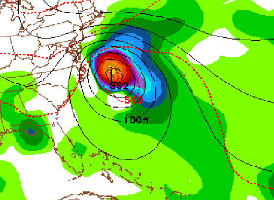
Nothing to really take away from this. Still way too far out. However, models in their "fantasy" time range are beginning to show "fantasy" storms, for the first time this season. So the tropics are coming alive.

Nothing to really take away from this. Still way too far out. However, models in their "fantasy" time range are beginning to show "fantasy" storms, for the first time this season. So the tropics are coming alive.
 Re: All Tropics Talk Thread 1.0
Although the image Frank showed is in fantasy land 300+ hrs out all three major models, (GFS, CMC, Euro) have that as a tropical system in the area around the Lesser Antillies between Sept 2-4th. The Euro is a little slower and weaker with its overall development, but it is there. The exact position of the system as well as how strong it is during the first week of Sept is a mute point this far out; however, what is important is that there is consistency for the moment amongst 3 of the major global models showing a tropical system potentially affecting the area of the Lesser Antillies around Sept 2nd - Sept 4th time frame.


_________________
"In weather and in life, there's no winning and losing; there's only winning and learning."
WINTER 2012/2013 TOTALS 43.65"WINTER 2017/2018 TOTALS 62.85" WINTER 2022/2023 TOTALS 4.9"
WINTER 2013/2014 TOTALS 64.85"WINTER 2018/2019 TOTALS 14.25" WINTER 2023/2024 TOTALS 13.1"
WINTER 2014/2015 TOTALS 71.20"WINTER 2019/2020 TOTALS 6.35"
WINTER 2015/2016 TOTALS 35.00"WINTER 2020/2021 TOTALS 37.75"
WINTER 2016/2017 TOTALS 42.25"WINTER 2021/2022 TOTALS 31.65"

sroc4- Admin

- Posts : 8331
Reputation : 301
Join date : 2013-01-07
Location : Wading River, LI
 Re: All Tropics Talk Thread 1.0
Nice, all 3 models are showing it.
Although, I'll be rooting for this one to either go out to sea or go into the Gulf. Lol.
Although, I'll be rooting for this one to either go out to sea or go into the Gulf. Lol.
 Re: All Tropics Talk Thread 1.0
Joe Bastardi
"US East coast may be threatened Sept 5-12 as pattern ripens to pull in what will become a much more African wave pattern for a few weeks"

Snow88- Senior Enthusiast

- Posts : 2193
Reputation : 4
Join date : 2013-01-09
Age : 35
Location : Brooklyn, NY
 Re: All Tropics Talk Thread 1.0
Doesn't the Farmers Almanac say something about hurricane threat the second week of September too?Snow88 wrote:
Joe Bastardi"US East coast may be threatened Sept 5-12 as pattern ripens to pull in what will become a much more African wave pattern for a few weeks"
 Re: All Tropics Talk Thread 1.0
You and me both. Now that I am a home owner and am surrounded by 100 yr old oak trees a recurve track is ok by me.Frank_Wx wrote:Nice, all 3 models are showing it.
Although, I'll be rooting for this one to either go out to sea or go into the Gulf. Lol.
_________________
"In weather and in life, there's no winning and losing; there's only winning and learning."
WINTER 2012/2013 TOTALS 43.65"WINTER 2017/2018 TOTALS 62.85" WINTER 2022/2023 TOTALS 4.9"
WINTER 2013/2014 TOTALS 64.85"WINTER 2018/2019 TOTALS 14.25" WINTER 2023/2024 TOTALS 13.1"
WINTER 2014/2015 TOTALS 71.20"WINTER 2019/2020 TOTALS 6.35"
WINTER 2015/2016 TOTALS 35.00"WINTER 2020/2021 TOTALS 37.75"
WINTER 2016/2017 TOTALS 42.25"WINTER 2021/2022 TOTALS 31.65"

sroc4- Admin

- Posts : 8331
Reputation : 301
Join date : 2013-01-07
Location : Wading River, LI
 Re: All Tropics Talk Thread 1.0
Oh boy here we go again - I feel like we are like the southeast! I hope this and the "others" stay away from us for those who have just finished repairs etc. from Sandy or as many have not. Just spent a week at the Jersey strong or ripped shore - my God the damage still is incredible - pulled a 5' section of boardwalk railing from the edge of the surf last week in Sea Girt that was buried in sand upside down - what else in lingering out there?
Something to say that all major models are showing this trop system but only time will tell. Thanks for the info boys.
Something to say that all major models are showing this trop system but only time will tell. Thanks for the info boys.
_________________
Mugs
AKA:King: Snow Weenie
Self Proclaimed
WINTER 2014-15 : 55.12" +.02 for 6 coatings (avg. 35")
WINTER 2015-16 Total - 29.8" (Avg 35")
WINTER 2016-17 : 39.5" so far

amugs- Advanced Forecaster - Mod

- Posts : 15093
Reputation : 213
Join date : 2013-01-07
Age : 54
Location : Hillsdale,NJ
 Re: All Tropics Talk Thread 1.0
We have Tropical Storm Fernand in the southern Gulf. Will make landfall in Mexico tonight......

Best part is, it definitly looked like it was the healthiest and best looking tropical Storm of the year to me...lol

Best part is, it definitly looked like it was the healthiest and best looking tropical Storm of the year to me...lol

Quietace- Meteorologist - Mod

- Posts : 3687
Reputation : 33
Join date : 2013-01-07
Age : 27
Location : Point Pleasant, NJ
 Re: All Tropics Talk Thread 1.0
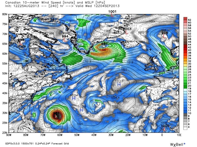
12z GEM
12zGEFS

12z EURO has the wave survive all the way across the Atlantic, and has two more behind it. Has a definite ripe pattern for a east coast threat as we've been saying. Trough in the east and a offshore Bermuda high allowing for recurving...Im also rooting heavily for a miss as i live 10 feet from the water.....


12zGEFS

12z EURO has the wave survive all the way across the Atlantic, and has two more behind it. Has a definite ripe pattern for a east coast threat as we've been saying. Trough in the east and a offshore Bermuda high allowing for recurving...Im also rooting heavily for a miss as i live 10 feet from the water.....


Quietace- Meteorologist - Mod

- Posts : 3687
Reputation : 33
Join date : 2013-01-07
Age : 27
Location : Point Pleasant, NJ
 Re: All Tropics Talk Thread 1.0
Just a quick Tropical update on a few observations Im seeing right now. There is an open tropical wave currently located at 15*/40* lat/long that has some general rotation associated with it, even at the surface; however, it currently lacks the convection needed to get it to spin up tight into a tropical cyclone. Here is the still image with the lat/long coodinates, followed by the loop.

http://www.ssd.noaa.gov/goes/east/catl/flash-rgb.html
http://www.ssd.noaa.gov/goes/east/tatl/rgb-animated.gif
As you can see there is not a lot of convection at the moment.
http://www.ssd.noaa.gov/goes/east/catl/flash-rb.html
But I think that might change. Currently it is headed on a mostly westerly track with slight shift to the WNW as it heads towards the northern fringe of the lesser antillies. The current steering layers indicate it should continue that way for at least the next 2-3days.
http://tropic.ssec.wisc.edu/real-time/dlmmain.php?&basin=atlantic&sat=wg8&prod=dlm1&zoom=&time=
At the moment this wave does not have very well organized vorticity at 850mb(4-6000ft above sea level), or 700mb (8-10,000 ft above sea level). Notice in the images below the vorticity is weak, and strung out a bit north to south along the 40* longitude line. At 500mb (16-18,000 ft above sea level) there is a more concentrated area of vorticity but you can see it is centered further south, and east of where the 850mb and 700mb vorticity is located. In order to see a trop cyclone we need the 850, 700, and 500mb vorticity be more stacked over the top of one another, and be more of a discrete circle with red colors at the center which would indicate tighter more concentrated spin.
850mb
http://tropic.ssec.wisc.edu/real-time/windmain.php?&basin=atlantic&sat=wg8&prod=vor&zoom=&time=
700mb
http://tropic.ssec.wisc.edu/real-time/windmain.php?&basin=atlantic&sat=wg8&prod=vor3&zoom=&time=
500mb
http://tropic.ssec.wisc.edu/real-time/windmain.php?&basin=atlantic&sat=wg8&prod=vor2&zoom=&time=
I believe that in the next couple of days as this wave heads west it will be heading over warmer waters than it is currently over, and headed closer to more rising unstable air. As seen in this water vapor imagery loop...
http://www.ssd.noaa.gov/goes/east/tatl/flash-wv.html
the area of dry stable air is being slowly closed in from all sides. There is even a very small area of convection in the center of it just east of the northern fringe of the lesser Antillies. The MJO pulse (large broad area of rising air) is slowly propagating eastward, and soon will intercept this current tropical wave, as well as others behind it, which should allow for convection to start firing up. IMHO in about 2days (+/-) the NHC will be rapidly increasing this waves chance at becoming tropical. The only observation I am seeing currently that might inhibit actual formation is the northern fringe has shear values near 30mph or so. I have not looked at what the shear is predicted to do however.
http://tropic.ssec.wisc.edu/real-time/windmain.php?&basin=atlantic&sat=wg8&prod=shr&zoom=&time=
Ciao for now.
_________________
"In weather and in life, there's no winning and losing; there's only winning and learning."
WINTER 2012/2013 TOTALS 43.65"WINTER 2017/2018 TOTALS 62.85" WINTER 2022/2023 TOTALS 4.9"
WINTER 2013/2014 TOTALS 64.85"WINTER 2018/2019 TOTALS 14.25" WINTER 2023/2024 TOTALS 13.1"
WINTER 2014/2015 TOTALS 71.20"WINTER 2019/2020 TOTALS 6.35"
WINTER 2015/2016 TOTALS 35.00"WINTER 2020/2021 TOTALS 37.75"
WINTER 2016/2017 TOTALS 42.25"WINTER 2021/2022 TOTALS 31.65"

sroc4- Admin

- Posts : 8331
Reputation : 301
Join date : 2013-01-07
Location : Wading River, LI
 Re: All Tropics Talk Thread 1.0
The Canadian model has a tropical storm making landfall in NJ at 240 hours out.

 Re: All Tropics Talk Thread 1.0
Frank, I see the point of interest but that is 10 days out and the models have trouble calling short term storms from past experiences. But I hear you and respect your forewarning it is something to watch. Another TS would be the dagger to our shore - after spending two vacation and riding on rt35 it is still in a fragile state - could it be another Sunday/Monday/Tuesday day frame storm like Irene and Sandy. That would be interesting.
Mugs
Mugs
_________________
Mugs
AKA:King: Snow Weenie
Self Proclaimed
WINTER 2014-15 : 55.12" +.02 for 6 coatings (avg. 35")
WINTER 2015-16 Total - 29.8" (Avg 35")
WINTER 2016-17 : 39.5" so far

amugs- Advanced Forecaster - Mod

- Posts : 15093
Reputation : 213
Join date : 2013-01-07
Age : 54
Location : Hillsdale,NJ
 Re: All Tropics Talk Thread 1.0
I don't expect it to happen, hence the "rolls eye" smiley. But it's been awhile since we've even seem a fantasy storm on the models. I don't want any tropical storms near the east coast, let alone NJ.
Page 4 of 6 •  1, 2, 3, 4, 5, 6
Permissions in this forum:
You cannot reply to topics in this forum|
|
|

 Home
Home