
 Search
Long Range Thread 9.0
Page 11 of 40 •  1 ... 7 ... 10, 11, 12 ... 25 ... 40
 ![]()
Re: Long Range Thread 9.0
![]() by skinsfan1177 Fri Jan 08, 2016 2:27 pm
by skinsfan1177 Fri Jan 08, 2016 2:27 pm
amugs wrote:At the end of the EURO run on Monday Jan 18th every state has an area below freezing as the 32* line is in the Gulf just off the coast - wow! CONUS in the freezer!!
In your opinion mugs does it look like their are many storms after the 18th as well
skinsfan1177- Senior Enthusiast

- Posts : 4485
Join date : 2013-01-07
Re: Long Range Thread 9.0
![]() by nutleyblizzard Fri Jan 08, 2016 2:27 pm
by nutleyblizzard Fri Jan 08, 2016 2:27 pm
Wow! Models are all over the place. Not only can they figure out any potential storm tracks, the temp profiles have changed too. Just yesterday there was concern for temperatures with next weekends storm. That map looks cold enough to me.amugs wrote:THERMALS ALERT - FEB 2015 INCOMING HERE!!
See what I was saying and yuo can sure as heck bet we will have squall lines moving through with so many lobes of energy swinging off teh PAC - on , two or three of them will produce.


nutleyblizzard- Senior Enthusiast
- Posts : 1952
Join date : 2014-01-30
Re: Long Range Thread 9.0
![]() by skinsfan1177 Fri Jan 08, 2016 2:31 pm
by skinsfan1177 Fri Jan 08, 2016 2:31 pm
Looks plenty cold!!nutleyblizzard wrote:Wow! Models are all over the place. Not only can they figure out any potential storm tracks, the temp profiles have changed too. Just yesterday there was concern for temperatures with next weekends storm. That map looks cold enough to me.amugs wrote:THERMALS ALERT - FEB 2015 INCOMING HERE!!
See what I was saying and yuo can sure as heck bet we will have squall lines moving through with so many lobes of energy swinging off teh PAC - on , two or three of them will produce.

skinsfan1177- Senior Enthusiast
- Posts : 4485
Reputation : 35
Join date : 2013-01-07
Age : 46
Location : Point Pleasant Boro
Re: Long Range Thread 9.0
![]() by amugs Fri Jan 08, 2016 6:05 pm
by amugs Fri Jan 08, 2016 6:05 pm
AS I said before you will
"Build it and he (it) will come............."
_________________
Mugs
AKA:King: Snow Weenie
Self Proclaimed
WINTER 2014-15 : 55.12" +.02 for 6 coatings (avg. 35")
WINTER 2015-16 Total - 29.8" (Avg 35")
WINTER 2016-17 : 39.5" so far

amugs- Advanced Forecaster - Mod

- Posts : 15093
Reputation : 213
Join date : 2013-01-07
Age : 54
Location : Hillsdale,NJ
Re: Long Range Thread 9.0
![]() by amugs Fri Jan 08, 2016 6:09 pm
by amugs Fri Jan 08, 2016 6:09 pm
We're definitely not behind the 1958 progression, and I would argue at least 5 days ahead of its progression. Still like the Jan 20th-30th period for a 10hpa split attempt. The progged evolution with upper stratospheric warming via the Aleutian and Eurasian highs is precisely the precursor one would seek.
If it doesn't occur, of course, that doesn't mean winter's over. However, if it occurs, we would likely maintain a protracted period of severe blocking through February. I would expect the AO and NAO to average negative in February regardless, but a SSW would increase the magnitude.

Today's 12z Euro run depicts the extremely elongated 10hpa vortex via the dual pressing by the 18th.
_________________
Mugs
AKA:King: Snow Weenie
Self Proclaimed
WINTER 2014-15 : 55.12" +.02 for 6 coatings (avg. 35")
WINTER 2015-16 Total - 29.8" (Avg 35")
WINTER 2016-17 : 39.5" so far
amugs- Advanced Forecaster - Mod
- Posts : 15093
Reputation : 213
Join date : 2013-01-07
Age : 54
Location : Hillsdale,NJ
Re: Long Range Thread 9.0
![]() by skinsfan1177 Fri Jan 08, 2016 6:41 pm
by skinsfan1177 Fri Jan 08, 2016 6:41 pm
skinsfan1177- Senior Enthusiast
- Posts : 4485
Reputation : 35
Join date : 2013-01-07
Age : 46
Location : Point Pleasant Boro
Re: Long Range Thread 9.0
![]() by skinsfan1177 Fri Jan 08, 2016 6:44 pm
by skinsfan1177 Fri Jan 08, 2016 6:44 pm
amugs wrote:Isotherm post on the PV Stratosphere condition
We're definitely not behind the 1958 progression, and I would argue at least 5 days ahead of its progression. Still like the Jan 20th-30th period for a 10hpa split attempt. The progged evolution with upper stratospheric warming via the Aleutian and Eurasian highs is precisely the precursor one would seek.
If it doesn't occur, of course, that doesn't mean winter's over. However, if it occurs, we would likely maintain a protracted period of severe blocking through February. I would expect the AO and NAO to average negative in February regardless, but a SSW would increase the magnitude.
Today's 12z Euro run depicts the extremely elongated 10hpa vortex via the dual pressing by the 18th.
Mugs where do you get these reads from isotherm. His knowledge if great!
skinsfan1177- Senior Enthusiast
- Posts : 4485
Reputation : 35
Join date : 2013-01-07
Age : 46
Location : Point Pleasant Boro
Re: Long Range Thread 9.0
![]() by jmanley32 Fri Jan 08, 2016 7:04 pm
by jmanley32 Fri Jan 08, 2016 7:04 pm

jmanley32- Senior Enthusiast
- Posts : 20517
Reputation : 108
Join date : 2013-12-12
Age : 42
Location : Yonkers, NY
Re: Long Range Thread 9.0
![]() by amugs Fri Jan 08, 2016 8:43 pm
by amugs Fri Jan 08, 2016 8:43 pm
jmanley32 wrote:18z GFS has bombing coastal after coastal, but all offshore, the potential is there just too far out at this time. I know one will produce big time I just get that feeling.
With a N over the SE and heights high over the NA one or two of these beasts is going to turn north and it maybe a last minute job - like BD 2010 with the block modelled. Models will have a hard time and dop handling all of these dynamics in teh atmosphere.
GEFS look good - pretty deep for the clipper

EPS does too
Clipper

_________________
Mugs
AKA:King: Snow Weenie
Self Proclaimed
WINTER 2014-15 : 55.12" +.02 for 6 coatings (avg. 35")
WINTER 2015-16 Total - 29.8" (Avg 35")
WINTER 2016-17 : 39.5" so far
amugs- Advanced Forecaster - Mod
- Posts : 15093
Reputation : 213
Join date : 2013-01-07
Age : 54
Location : Hillsdale,NJ
Re: Long Range Thread 9.0
![]() by snow247 Fri Jan 08, 2016 11:19 pm
by snow247 Fri Jan 08, 2016 11:19 pm
Edit: GFS not good. But still many days away, at least the signal is there.
Last edited by snow247 on Fri Jan 08, 2016 11:34 pm; edited 2 times in total

snow247- Pro Enthusiast

- Posts : 2417
Reputation : 0
Join date : 2014-08-27
Location : Mount Ivy, NY - Elevation 545'
Re: Long Range Thread 9.0
![]() by Frank_Wx Fri Jan 08, 2016 11:33 pm
by Frank_Wx Fri Jan 08, 2016 11:33 pm
_________________
_______________________________________________________________________________________________________
CLICK HERE to view NJ Strong Snowstorm Classifications

Frank_Wx- Godzilla Seeker

- Posts : 21305
Reputation : 328
Join date : 2013-01-05
Age : 31
Location : Jersey City, NJ -

Re: Long Range Thread 9.0
![]() by weatherwatchermom Fri Jan 08, 2016 11:41 pm
by weatherwatchermom Fri Jan 08, 2016 11:41 pm
Hey are you talking about Wed? Just curiousFrank_Wx wrote:There is no phase. It's a weak southern stream driven system. There is no western ridge to dig the northern energy. The northern energy also closes off, which makes it less susceptible to digging into the eastern CONUS.

weatherwatchermom- Senior Enthusiast
- Posts : 3750
Reputation : 77
Join date : 2014-11-25
Age : 60
Location : Hazlet Township, NJ
Re: Long Range Thread 9.0
![]() by snow247 Fri Jan 08, 2016 11:45 pm
by snow247 Fri Jan 08, 2016 11:45 pm
weatherwatchermom wrote:Hey are you talking about Wed? Just curiousFrank_Wx wrote:There is no phase. It's a weak southern stream driven system. There is no western ridge to dig the northern energy. The northern energy also closes off, which makes it less susceptible to digging into the eastern CONUS.
No, he's talking about the threat for around the 17th.
The Wednesday snow threat discussion is in it's own thread https://www.njstrongweatherforum.com/t623-01-13-clipper-system
snow247- Pro Enthusiast
- Posts : 2417
Reputation : 0
Join date : 2014-08-27
Location : Mount Ivy, NY - Elevation 545'
Re: Long Range Thread 9.0
![]() by Frank_Wx Fri Jan 08, 2016 11:48 pm
by Frank_Wx Fri Jan 08, 2016 11:48 pm

_________________
_______________________________________________________________________________________________________
CLICK HERE to view NJ Strong Snowstorm Classifications
Frank_Wx- Godzilla Seeker
- Posts : 21305
Reputation : 328
Join date : 2013-01-05
Age : 31
Location : Jersey City, NJ -
Re: Long Range Thread 9.0
![]() by Frank_Wx Fri Jan 08, 2016 11:51 pm
by Frank_Wx Fri Jan 08, 2016 11:51 pm

_________________
_______________________________________________________________________________________________________
CLICK HERE to view NJ Strong Snowstorm Classifications
Frank_Wx- Godzilla Seeker
- Posts : 21305
Reputation : 328
Join date : 2013-01-05
Age : 31
Location : Jersey City, NJ -
Re: Long Range Thread 9.0
![]() by Snow88 Sat Jan 09, 2016 12:01 am
by Snow88 Sat Jan 09, 2016 12:01 am

Snow88- Senior Enthusiast
- Posts : 2193
Reputation : 4
Join date : 2013-01-09
Age : 35
Location : Brooklyn, NY
Re: Long Range Thread 9.0
![]() by Frank_Wx Sat Jan 09, 2016 12:01 am
by Frank_Wx Sat Jan 09, 2016 12:01 am
Snow88 wrote:Wow, very active GFS run. Storm after Storm after Storm even though none of them really hit the area. The models are going to be all over the place until it gets near to the storm. The pattern is really explosive and has big potential.
Agree.
_________________
_______________________________________________________________________________________________________
CLICK HERE to view NJ Strong Snowstorm Classifications
Frank_Wx- Godzilla Seeker
- Posts : 21305
Reputation : 328
Join date : 2013-01-05
Age : 31
Location : Jersey City, NJ -
Re: Long Range Thread 9.0
![]() by weatherwatchermom Sat Jan 09, 2016 12:04 am
by weatherwatchermom Sat Jan 09, 2016 12:04 am
ThAnk yousnow247 wrote:weatherwatchermom wrote:Hey are you talking about Wed? Just curiousFrank_Wx wrote:There is no phase. It's a weak southern stream driven system. There is no western ridge to dig the northern energy. The northern energy also closes off, which makes it less susceptible to digging into the eastern CONUS.
No, he's talking about the threat for around the 17th.
The Wednesday snow threat discussion is in it's own thread https://www.njstrongweatherforum.com/t623-01-13-clipper-system
weatherwatchermom- Senior Enthusiast
- Posts : 3750
Reputation : 77
Join date : 2014-11-25
Age : 60
Location : Hazlet Township, NJ
Re: Long Range Thread 9.0
![]() by snow247 Sat Jan 09, 2016 1:38 am
by snow247 Sat Jan 09, 2016 1:38 am
Very close to a huge storm for us. Potential is closer than we think.
snow247- Pro Enthusiast
- Posts : 2417
Reputation : 0
Join date : 2014-08-27
Location : Mount Ivy, NY - Elevation 545'
Re: Long Range Thread 9.0
![]() by justin92 Sat Jan 09, 2016 1:46 am
by justin92 Sat Jan 09, 2016 1:46 am
justin92- Posts : 16
Reputation : 0
Join date : 2016-01-01
Re: Long Range Thread 9.0
![]() by Snow88 Sat Jan 09, 2016 2:04 am
by Snow88 Sat Jan 09, 2016 2:04 am
Snow88- Senior Enthusiast
- Posts : 2193
Reputation : 4
Join date : 2013-01-09
Age : 35
Location : Brooklyn, NY
snow247- Pro Enthusiast
- Posts : 2417
Reputation : 0
Join date : 2014-08-27
Location : Mount Ivy, NY - Elevation 545'
Re: Long Range Thread 9.0
![]() by sroc4 Sat Jan 09, 2016 7:08 am
by sroc4 Sat Jan 09, 2016 7:08 am
The north American continent is like a caldron of vorticity with the hand of mother nature simply stirring the pot. With each model run she stops to taste her brew only to say..."nope not enough this and not enough that. Lets add a dash more this and a pinch more of that." Then back to stirring the pot she goes until the next model run output.
Just to give you some idea of what I mean lets compare yesterday's 12z 500mb maps to last nights 00z 500mb maps for each individual global model with all maps valid for 00z Jan 18th. (GFS I compared last nights 00z to this am's 06z. The rest are 12z and 00z). Take particular notice just how drastically different each models individual runs are from 12z to 00z. The placement and strengths of the different areas of vorticity, the ridging out west, etc are night and day different from one run to the next, AND from one model to the next. We are going to be beating a dead horse when we say this because I know its been said already but we still have ZERO consensus on this threat, and will not know if this is truly the real deal until under 5-7days out AT BEST IMO. The ensembles are still spread out although are very encouraging.
GFS:
00z:
 " />
" />06z:
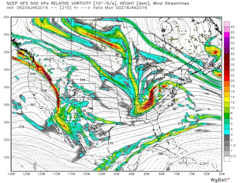 " />
" /> CMC:
12z:
 " />
" />00z:
 " />
" />EURO:
12z:
 " />
" />00z:
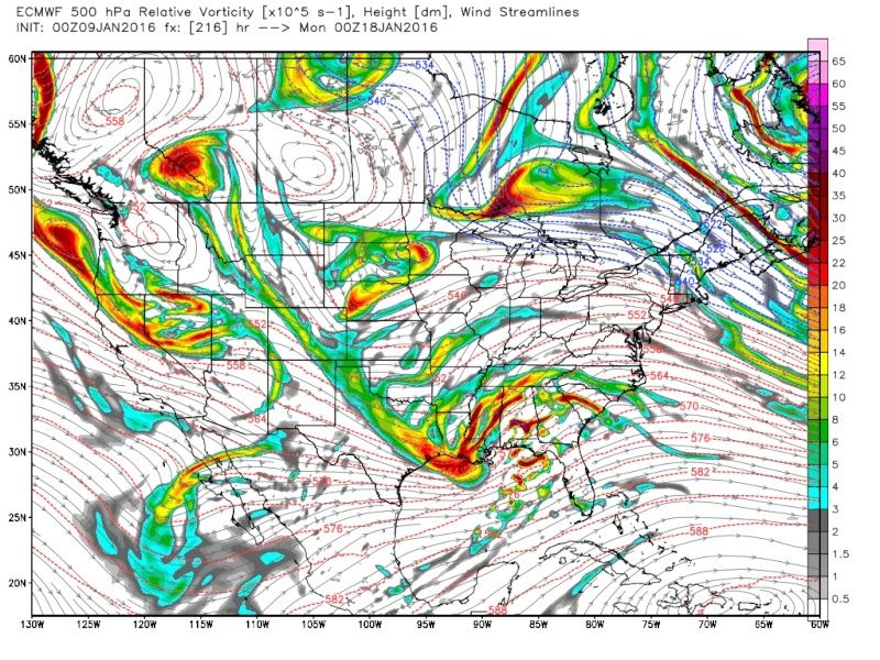 " />
" />Last edited by sroc4 on Sat Jan 09, 2016 7:28 am; edited 1 time in total
_________________
"In weather and in life, there's no winning and losing; there's only winning and learning."
WINTER 2012/2013 TOTALS 43.65"WINTER 2017/2018 TOTALS 62.85" WINTER 2022/2023 TOTALS 4.9"
WINTER 2013/2014 TOTALS 64.85"WINTER 2018/2019 TOTALS 14.25" WINTER 2023/2024 TOTALS 13.1"
WINTER 2014/2015 TOTALS 71.20"WINTER 2019/2020 TOTALS 6.35"
WINTER 2015/2016 TOTALS 35.00"WINTER 2020/2021 TOTALS 37.75"
WINTER 2016/2017 TOTALS 42.25"WINTER 2021/2022 TOTALS 31.65"

sroc4- Admin
- Posts : 8331
Reputation : 301
Join date : 2013-01-07
Location : Wading River, LI
Re: Long Range Thread 9.0
![]() by skinsfan1177 Sat Jan 09, 2016 7:27 am
by skinsfan1177 Sat Jan 09, 2016 7:27 am
Way to early to know where it will snow at this pointsnow247 wrote:6z GFS is an all out inland snowstorm.
skinsfan1177- Senior Enthusiast
- Posts : 4485
Reputation : 35
Join date : 2013-01-07
Age : 46
Location : Point Pleasant Boro
Re: Long Range Thread 9.0
![]() by Quietace Sat Jan 09, 2016 8:14 am
by Quietace Sat Jan 09, 2016 8:14 am
Model skill set rapidly decreases in amplified active patterns. When observing guidance, as others have mentioned; is the fact have not focused on a single event(they have began to converge). It is possible, due to the vast number of areas of vorticity, that we may have a number of events in sequence, not just a single large event; and models are just having issues handling such a meridional flow. For example the ECMWF last night had a large system around the 15th, then another system around the 19th, then what looks to be another system destined for EC cyclogensis a few days later. This makes sense given the 500mb evolution on both the EPS, and GEFS; that with such a slow, and locked in flow.sroc4 wrote:Wow is all I have to say with the overnight 00z suites. If there was ever a definition of a powder keg of potential this is it. Of course it doesn't mean it will be set off but man O man this could be crazy if it all comes together. There is sooo much energy swirling around not a single operational model has even a clue right now on the where, the what, or the how its all going to interact.
The north American continent is like a caldron of vorticity with the hand of mother nature simply stirring the pot. With each model run she stops to taste her brew only to say..."nope not enough this and not enough that. Lets add a dash more this and a pinch more of that." Then back to stirring the pot she goes until the next model run output.
Just to give you some idea of what I mean lets compare yesterday's 12z 500mb maps to last nights 00z 500mb maps for each individual global model with all maps valid for 00z Jan 18th. (GFS I compared last nights 00z to this am's 06z. The rest are 12z and 00z). Take particular notice just how drastically different each models individual runs are from 12z to 00z. The placement and strengths of the different areas of vorticity, the ridging out west, etc are night and day different from one run to the next, AND from one model to the next. We are going to be beating a dead horse when we say this because I know its been said already but we still have ZERO consensus on this threat, and will not know if this is truly the real deal until under 5-7days out AT BEST IMO. The ensembles are still spread out although are very encouraging.
GFS:
00z:
06z:
CMC:
12z:
00z:
EURO:
12z:
00z:

Quietace- Meteorologist - Mod

- Posts : 3687
Reputation : 33
Join date : 2013-01-07
Age : 27
Location : Point Pleasant, NJ
Re: Long Range Thread 9.0
![]() by Snow88 Sat Jan 09, 2016 8:55 am
by Snow88 Sat Jan 09, 2016 8:55 am
Snow88- Senior Enthusiast
- Posts : 2193
Reputation : 4
Join date : 2013-01-09
Age : 35
Location : Brooklyn, NY
Re: Long Range Thread 9.0
![]() by NjWeatherGuy Sat Jan 09, 2016 9:05 am
by NjWeatherGuy Sat Jan 09, 2016 9:05 am
http://mag.ncep.noaa.gov/Image.php?fhr=225&image=data%2Fgfs%2F06%2Fgfs_namer_225_850_temp_mslp_precip.gif&model=gfs&area=namer¶m=850_temp_mslp_precip&group=Model+Guidance&preselected_formatted_cycle_date=20160109+06+UTC&imageSize=M&ps=model

NjWeatherGuy- Advanced Forecaster

- Posts : 4100
Reputation : 28
Join date : 2013-01-06
Location : Belle Mead, NJ
Page 11 of 40 • 1 ... 7 ... 10, 11, 12 ... 25 ... 40 ![]()
|
|
|