
 Search
Long Range Thread 9.0
Page 23 of 40 •  1 ... 13 ... 22, 23, 24 ... 31 ... 40
 ![]()
Re: Long Range Thread 9.0
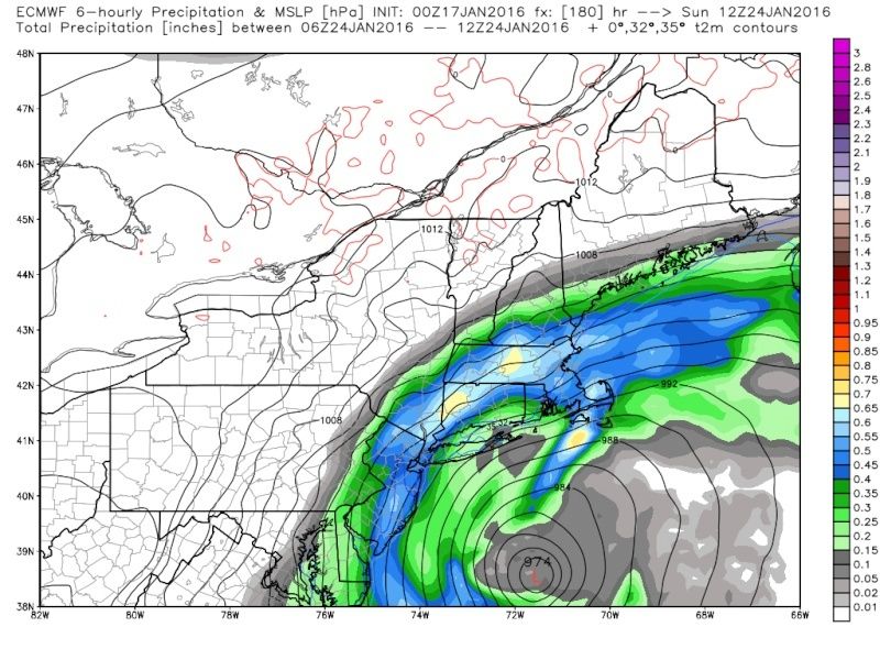
![]() by chief7 Sun Jan 17, 2016 5:53 am
by chief7 Sun Jan 17, 2016 5:53 am
chief7- Posts : 132
Join date : 2013-11-10
Re: Long Range Thread 9.0
![]() by skinsfan1177 Sun Jan 17, 2016 6:00 am
by skinsfan1177 Sun Jan 17, 2016 6:00 am
Yeah but I think with cold air in place and if it's a strong storm it should bring down the cold air.chief7 wrote:That's what I'm a little bit concerned about their skins the low getting too close to the coast
skinsfan1177- Senior Enthusiast

- Posts : 4485
Join date : 2013-01-07
Re: Long Range Thread 9.0
![]() by SNOW MAN Sun Jan 17, 2016 6:20 am
by SNOW MAN Sun Jan 17, 2016 6:20 am
I watched channel 4 in NY last night and they also mentioned a possible snow event for next weekend. I guess will have to see what our crack team of forecaster say in a few days when things become more clear. Got to run. See you all later.

SNOW MAN- Senior Enthusiast
- Posts : 1361
Reputation : 25
Join date : 2013-01-13
Age : 64
Location : Marshalls Creek Pa.
Re: Long Range Thread 9.0
![]() by Quietace Sun Jan 17, 2016 6:33 am
by Quietace Sun Jan 17, 2016 6:33 am
Verbatim on all models, once the low intensify and occludes, the 0C line is in N/SC, with surface temps supporting frozen precip.chief7 wrote:That's what I'm a little bit concerned about their skins the low getting too close to the coast

Quietace- Meteorologist - Mod

- Posts : 3687
Reputation : 33
Join date : 2013-01-07
Age : 27
Location : Point Pleasant, NJ
Re: Long Range Thread 9.0
![]() by skinsfan1177 Sun Jan 17, 2016 7:15 am
by skinsfan1177 Sun Jan 17, 2016 7:15 am
SNOW MAN wrote:I just watched the weather from my local TV station and when they put up the seven day forecast she said there would be a coastal storm coming up the East coast that would dump heavy snow for the whole area. She said the GFS was showing it would be a Friday/Saturday event and the Euro was showing Sunday. I found this unusual because they usually downplay any snow event before or even while it's happening. I know it's to early to call anything yet, but could this be a good sign or the old proverbial KOD. She also said the NWS long range temp outlook showed above normal temps for most of the nation after the storm passes.
I watched channel 4 in NY last night and they also mentioned a possible snow event for next weekend. I guess will have to see what our crack team of forecaster say in a few days when things become more clear. Got to run. See you all later.
Usually not a good sign if their mentioning this far ahead KOD no doubt. But this year is not the norm so who knows if by weds it's still their then I will be very excited until then it's model watching time

skinsfan1177- Senior Enthusiast
- Posts : 4485
Reputation : 35
Join date : 2013-01-07
Age : 46
Location : Point Pleasant Boro

Snow88- Senior Enthusiast
- Posts : 2193
Reputation : 4
Join date : 2013-01-09
Age : 35
Location : Brooklyn, NY
Re: Long Range Thread 9.0
![]() by Frank_Wx Sun Jan 17, 2016 8:14 am
by Frank_Wx Sun Jan 17, 2016 8:14 am


_________________
_______________________________________________________________________________________________________
CLICK HERE to view NJ Strong Snowstorm Classifications

Frank_Wx- Godzilla Seeker

- Posts : 21305
Reputation : 328
Join date : 2013-01-05
Age : 31
Location : Jersey City, NJ -

Re: Long Range Thread 9.0
![]() by Quietace Sun Jan 17, 2016 8:18 am
by Quietace Sun Jan 17, 2016 8:18 am
Comparatively,Frank_Wx wrote:The 00z EURO-PARA, which has better stats than the current EURO-OP, showed a beast last nught.


Quietace- Meteorologist - Mod
- Posts : 3687
Reputation : 33
Join date : 2013-01-07
Age : 27
Location : Point Pleasant, NJ
Re: Long Range Thread 9.0
![]() by skinsfan1177 Sun Jan 17, 2016 8:24 am
by skinsfan1177 Sun Jan 17, 2016 8:24 am
skinsfan1177- Senior Enthusiast
- Posts : 4485
Reputation : 35
Join date : 2013-01-07
Age : 46
Location : Point Pleasant Boro
Re: Long Range Thread 9.0
![]() by rb924119 Sun Jan 17, 2016 8:35 am
by rb924119 Sun Jan 17, 2016 8:35 am
jmanley32 wrote:Frank_Wx wrote:The 00z EURO-PARA, which has better stats than the current EURO-OP, showed a beast last nught.
wow i can only imagine how much snow that puts down. where do i find the para surface maps ive looked on wxbell.
Here Jman:

And this is only with 10:1 ratios. Totals would be 20-30" region-wide verbatim if this verified. Again, not getting excited yet because of how volatile this pattern has been, but hopeful. Very, very hopeful hahaha
Last edited by rb924119 on Sun Jan 17, 2016 8:37 am; edited 1 time in total
rb924119- Meteorologist

- Posts : 6889
Reputation : 194
Join date : 2013-02-06
Age : 32
Location : Greentown, Pa
Re: Long Range Thread 9.0
![]() by crippo84 Sun Jan 17, 2016 8:36 am
by crippo84 Sun Jan 17, 2016 8:36 am

crippo84- Posts : 383
Reputation : 20
Join date : 2013-11-07
Age : 40
Location : East Village, NYC
Re: Long Range Thread 9.0
![]() by sroc4 Sun Jan 17, 2016 8:40 am
by sroc4 Sun Jan 17, 2016 8:40 am
 " />
" />[img]
 [/img]
Last edited by sroc4 on Sun Jan 17, 2016 8:42 am; edited 1 time in total
_________________
"In weather and in life, there's no winning and losing; there's only winning and learning."
WINTER 2012/2013 TOTALS 43.65"WINTER 2017/2018 TOTALS 62.85" WINTER 2022/2023 TOTALS 4.9"
WINTER 2013/2014 TOTALS 64.85"WINTER 2018/2019 TOTALS 14.25" WINTER 2023/2024 TOTALS 13.1"
WINTER 2014/2015 TOTALS 71.20"WINTER 2019/2020 TOTALS 6.35"
WINTER 2015/2016 TOTALS 35.00"WINTER 2020/2021 TOTALS 37.75"
WINTER 2016/2017 TOTALS 42.25"WINTER 2021/2022 TOTALS 31.65"

sroc4- Admin
- Posts : 8331
Reputation : 301
Join date : 2013-01-07
Location : Wading River, LI
Re: Long Range Thread 9.0
![]() by frank 638 Sun Jan 17, 2016 8:41 am
by frank 638 Sun Jan 17, 2016 8:41 am
frank 638- Senior Enthusiast
- Posts : 2824
Reputation : 37
Join date : 2016-01-01
Age : 40
Location : bronx ny
Re: Long Range Thread 9.0
![]() by jmanley32 Sun Jan 17, 2016 8:41 am
by jmanley32 Sun Jan 17, 2016 8:41 am
rb924119 wrote:jmanley32 wrote:Frank_Wx wrote:The 00z EURO-PARA, which has better stats than the current EURO-OP, showed a beast last nught.
wow i can only imagine how much snow that puts down. where do i find the para surface maps ive looked on wxbell.
Here Jman:
And this is only with 10:1 ratios. Totals would be 20-30" region-wide verbatim if this verified. Again, not getting excited yet because of how volatile this pattern has been, but hopeful. Very, very hopeful hahaha
I just found it wow......

jmanley32- Senior Enthusiast
- Posts : 20513
Reputation : 108
Join date : 2013-12-12
Age : 42
Location : Yonkers, NY
Re: Long Range Thread 9.0
![]() by skinsfan1177 Sun Jan 17, 2016 8:43 am
by skinsfan1177 Sun Jan 17, 2016 8:43 am
skinsfan1177- Senior Enthusiast
- Posts : 4485
Reputation : 35
Join date : 2013-01-07
Age : 46
Location : Point Pleasant Boro
Re: Long Range Thread 9.0
![]() by jmanley32 Sun Jan 17, 2016 8:44 am
by jmanley32 Sun Jan 17, 2016 8:44 am
crippo84 wrote:Lol hope it isn't the KOD but even TWC is very bullish on the 10 day forecast for this storm.
Not a huge believer in jinx's etc though the KOD thing here I know is felt strongly at times. I think the pros going at it to me anyways tells me how much they see the agreement like Frank said, we have never really seen before GFS,CMC Euro, Euro para and ensembles mostly all showing a all out godzilla (though 06z gfs isnt but still its far out its still going to change). I am though very surprised tht the pros are talking it up already. Wait too SM sees some of these maps.
jmanley32- Senior Enthusiast
- Posts : 20513
Reputation : 108
Join date : 2013-12-12
Age : 42
Location : Yonkers, NY
Re: Long Range Thread 9.0
![]() by Quietace Sun Jan 17, 2016 8:47 am
by Quietace Sun Jan 17, 2016 8:47 am
There is blocking upstream of the flow, but also confluence running E/W north of the system. After N/S stream phase the system also cuts of just east of NJ/LI currently as modeled.skinsfan1177 wrote:Can someone explain on why the the storm stalls and snows itself out. do we have blocking? I know things will definetly change this far out.
Quietace- Meteorologist - Mod
- Posts : 3687
Reputation : 33
Join date : 2013-01-07
Age : 27
Location : Point Pleasant, NJ
Re: Long Range Thread 9.0
![]() by amugs Sun Jan 17, 2016 8:48 am
by amugs Sun Jan 17, 2016 8:48 am
And there are more vorts in the pipeline behind this one with better spacing - POTENTIAL is a good thing at this point come wed/Night it starts to become KINETIC!!
_________________
Mugs
AKA:King: Snow Weenie
Self Proclaimed
WINTER 2014-15 : 55.12" +.02 for 6 coatings (avg. 35")
WINTER 2015-16 Total - 29.8" (Avg 35")
WINTER 2016-17 : 39.5" so far

amugs- Advanced Forecaster - Mod

- Posts : 15093
Reputation : 213
Join date : 2013-01-07
Age : 54
Location : Hillsdale,NJ
Re: Long Range Thread 9.0
![]() by Quietace Sun Jan 17, 2016 8:49 am
by Quietace Sun Jan 17, 2016 8:49 am
Quietace- Meteorologist - Mod
- Posts : 3687
Reputation : 33
Join date : 2013-01-07
Age : 27
Location : Point Pleasant, NJ
Re: Long Range Thread 9.0
![]() by Quietace Sun Jan 17, 2016 8:50 am
by Quietace Sun Jan 17, 2016 8:50 am

Quietace- Meteorologist - Mod
- Posts : 3687
Reputation : 33
Join date : 2013-01-07
Age : 27
Location : Point Pleasant, NJ
Re: Long Range Thread 9.0
![]() by sroc4 Sun Jan 17, 2016 8:58 am
by sroc4 Sun Jan 17, 2016 8:58 am
You will not hear much from me until at least Tuesday.
_________________
"In weather and in life, there's no winning and losing; there's only winning and learning."
WINTER 2012/2013 TOTALS 43.65"WINTER 2017/2018 TOTALS 62.85" WINTER 2022/2023 TOTALS 4.9"
WINTER 2013/2014 TOTALS 64.85"WINTER 2018/2019 TOTALS 14.25" WINTER 2023/2024 TOTALS 13.1"
WINTER 2014/2015 TOTALS 71.20"WINTER 2019/2020 TOTALS 6.35"
WINTER 2015/2016 TOTALS 35.00"WINTER 2020/2021 TOTALS 37.75"
WINTER 2016/2017 TOTALS 42.25"WINTER 2021/2022 TOTALS 31.65"
sroc4- Admin
- Posts : 8331
Reputation : 301
Join date : 2013-01-07
Location : Wading River, LI
Re: Long Range Thread 9.0
![]() by Dtone Sun Jan 17, 2016 9:04 am
by Dtone Sun Jan 17, 2016 9:04 am
crippo84 wrote:Lol hope it isn't the KOD but even TWC is very bullish on the 10 day forecast for this storm.
They have 2 - 3 days of steady snow in their forecast. They dont even have the usual words like "chance", or "snow possible", or "watching a winter storm" they usually use this far out.
This is for the whole I 95 corridor DC to NY, they are less bullish into New England
Last edited by Dtone on Sun Jan 17, 2016 9:16 am; edited 1 time in total
Dtone- Wx Statistician Guru

- Posts : 1738
Reputation : 9
Join date : 2013-08-26
Location : Bronx, NY
Re: Long Range Thread 9.0
![]() by chief7 Sun Jan 17, 2016 9:07 am
by chief7 Sun Jan 17, 2016 9:07 am
chief7- Posts : 132
Reputation : 0
Join date : 2013-11-10
Location : Langhorne pa
Re: Long Range Thread 9.0
![]() by jake732 Sun Jan 17, 2016 9:11 am
by jake732 Sun Jan 17, 2016 9:11 am

jake732- Pro Enthusiast

- Posts : 449
Reputation : 0
Join date : 2016-01-03
Location : lakewood, nj -
Re: Long Range Thread 9.0
![]() by rb924119 Sun Jan 17, 2016 9:15 am
by rb924119 Sun Jan 17, 2016 9:15 am

Now take a look at the 00z EURO Ensemble:

You can see that nearly all of the members denote the eastern troughing, and that's a good sign. However, take a look at the width of that trough according to a large majority of the members; the back-side is around the Mississippi while the leading edge is near the East Coast. Looking back at the GFS, the Euro Ensembles depict a broader trough, which favors a track further away from the coast and outside the Benchmark.
Lastly, here's the Canadian Ensemble:

Similarly to the GFS, there are several outlier members here in that they keep the entire flow progressive, which again skews the mean to a less amplified solution. That said, attempting to correct for this, it seems like this ensemble would lie somewhere in the middle of the GFS and EURO ensembles with respect to the broadness of the trough, and have it stretch from the Mississippi to the Appalachian range. This would likely result in a track near or slightly outside of the Benchmark.
In light of all this, which idea do I personally favor? Well, seeing as though the Pacific flow is expected to remain fast and active, which is why we see the collapse of the western ridge in the first place, and from memory telling me that these ridges have a tendency of collapsing faster than modeled, I'm favoring the EURO the most, followed by the Canadian then GFS (55%, 25%, 20%) at this time. I think a track just outside or outside the Benchmark seems likely. An added reason to my thinking is the fact that the EURO has a very large cluster of broader 500 hPa heights, and in a fast and progressive pattern, this makes sense to me because it's very difficult (if not impossible) to get and maintain an amplified pattern with nothing amplifying upstream of it, and no blocking downstream. I think the trough will already be starting to broaden and flatten out as we see our storm developing. Again, this is all being based on the data that we have right now, and is certainly open to changes, but those are my thoughts so far.
rb924119- Meteorologist
- Posts : 6889
Reputation : 194
Join date : 2013-02-06
Age : 32
Location : Greentown, Pa
Re: Long Range Thread 9.0
![]() by jmanley32 Sun Jan 17, 2016 9:18 am
by jmanley32 Sun Jan 17, 2016 9:18 am
local forecast if u read details on twc has 6 to 16 inches total. Thst is crazy to call thst this far out. Accuwx had nothing lol.Dtone wrote:crippo84 wrote:Lol hope it isn't the KOD but even TWC is very bullish on the 10 day forecast for this storm.
They have 2 - 3 days of steady snow in their forecast. They dont even have the usual words like "chance", or "snow possible", or "watching a winter storm" they usually use this far out.
This is for the whole I 95 corridor DC to NY, they are less bullish into New England
jmanley32- Senior Enthusiast
- Posts : 20513
Reputation : 108
Join date : 2013-12-12
Age : 42
Location : Yonkers, NY
Re: Long Range Thread 9.0
![]() by Frank_Wx Sun Jan 17, 2016 9:38 am
by Frank_Wx Sun Jan 17, 2016 9:38 am
_________________
_______________________________________________________________________________________________________
CLICK HERE to view NJ Strong Snowstorm Classifications
Frank_Wx- Godzilla Seeker
- Posts : 21305
Reputation : 328
Join date : 2013-01-05
Age : 31
Location : Jersey City, NJ -
Page 23 of 40 • 1 ... 13 ... 22, 23, 24 ... 31 ... 40 ![]()
|
|
|