
 Search
Long Range Thread 9.0
Page 35 of 40 •  1 ... 19 ... 34, 35, 36 ... 40
 ![]()
Re: Long Range Thread 9.0
![]() by Frank_Wx Mon Jan 25, 2016 6:19 pm
by Frank_Wx Mon Jan 25, 2016 6:19 pm

Frank_Wx- Godzilla Seeker

- Posts : 21305
Join date : 2013-01-05 -

Re: Long Range Thread 9.0
![]() by skinsfan1177 Mon Jan 25, 2016 6:22 pm
by skinsfan1177 Mon Jan 25, 2016 6:22 pm
Don't blame great work with this past storm and to the others.Frank_Wx wrote:skinsfan1177 wrote:Frank no mo moFrank_Wx wrote:syosnow94 wrote:No one likes my jersey shore reference huh? I thought that was a good line
Too tired from the Roidzilla tracking. Plus I did the storm in Review blog yesterday. Mo Mo's will return next Monday.

skinsfan1177- Senior Enthusiast

- Posts : 4485
Join date : 2013-01-07
Re: Long Range Thread 9.0
![]() by Grselig Mon Jan 25, 2016 7:38 pm
by Grselig Mon Jan 25, 2016 7:38 pm
Frank_Wx wrote:syosnow94 wrote:No one likes my jersey shore reference huh? I thought that was a good line
I like it. Good line!

Grselig- Senior Enthusiast
- Posts : 1408
Reputation : 140
Join date : 2013-03-04
Age : 54
Location : Wayne NJ
Re: Long Range Thread 9.0
![]() by amugs Mon Jan 25, 2016 9:30 pm
by amugs Mon Jan 25, 2016 9:30 pm
Yeah, I view that board occasionally; they have some good posters there, including Ed. However, a couple points:
[1] We have been benefiting from the stratosphere over recent weeks, and can continue to benefit from it, even if a technical SSW is not achieved. Over the past few weeks, the stratosphere has been quite perturbed, via the bottom up Kara ridge influence and the wave-1 hit into the upper stratosphere a couple weeks ago. This week, we are seeing an anomalously strong wave-1 pulse which would normally induce a major SSW, but the record strong / super charged vortex will probably prevent that. With that being said the 70-10hpa vortex will continue to receive hits with elongation and displacement (in the sense that it will be moved away from its current position) toward northern Europe. This alone, even without a technical SSW, helps to raise geopotential heights over AK / Canada / Arctic.
[2] Doug is correct in that things are a bit more complicated for Europe, particularly with displacements. If the vortex is not pushed sufficiently far south, the tropospheric reflection would probably not be blocky enough in the NATL to force a cold / snowy pattern in Europe. They really want to drive that vortex very far south off the pole. Here in the US, we can get cold a number of ways. For the United Kingdom to have a cold/snowy pattern, a strong negative NAO is almost a necessity. Now, I think that may occur in February regardless of the stratosphere but we'll see.
It appears Cohen's update today is quite bullish. He thinks we've commenced a SSW, which will culminate in an official major classification in February. Mentions a split is even possible. Certainly more bullish than I am. The robust state of this winter's vortex has made me doubt that even this anomalous wave activity will accomplish an official event this year. But we'll see.
I think as long as we continue to knock the PV around and force it away from the pole, the tropospheric pattern will be favorable. Also keep in mind tropospheric indicators which support the return of blocking in and of itself.
_________________
Mugs
AKA:King: Snow Weenie
Self Proclaimed
WINTER 2014-15 : 55.12" +.02 for 6 coatings (avg. 35")
WINTER 2015-16 Total - 29.8" (Avg 35")
WINTER 2016-17 : 39.5" so far

amugs- Advanced Forecaster - Mod

- Posts : 15093
Reputation : 213
Join date : 2013-01-07
Age : 54
Location : Hillsdale,NJ
Re: Long Range Thread 9.0
![]() by weatherwatchermom Mon Jan 25, 2016 9:57 pm
by weatherwatchermom Mon Jan 25, 2016 9:57 pm
Hey can you translate this to layman's terms thanks!!amugs wrote:Isotherm Update on the Strato: (Ed Otoole's comments that Frank Posted)
Yeah, I view that board occasionally; they have some good posters there, including Ed. However, a couple points:
[1] We have been benefiting from the stratosphere over recent weeks, and can continue to benefit from it, even if a technical SSW is not achieved. Over the past few weeks, the stratosphere has been quite perturbed, via the bottom up Kara ridge influence and the wave-1 hit into the upper stratosphere a couple weeks ago. This week, we are seeing an anomalously strong wave-1 pulse which would normally induce a major SSW, but the record strong / super charged vortex will probably prevent that. With that being said the 70-10hpa vortex will continue to receive hits with elongation and displacement (in the sense that it will be moved away from its current position) toward northern Europe. This alone, even without a technical SSW, helps to raise geopotential heights over AK / Canada / Arctic.
[2] Doug is correct in that things are a bit more complicated for Europe, particularly with displacements. If the vortex is not pushed sufficiently far south, the tropospheric reflection would probably not be blocky enough in the NATL to force a cold / snowy pattern in Europe. They really want to drive that vortex very far south off the pole. Here in the US, we can get cold a number of ways. For the United Kingdom to have a cold/snowy pattern, a strong negative NAO is almost a necessity. Now, I think that may occur in February regardless of the stratosphere but we'll see.
It appears Cohen's update today is quite bullish. He thinks we've commenced a SSW, which will culminate in an official major classification in February. Mentions a split is even possible. Certainly more bullish than I am. The robust state of this winter's vortex has made me doubt that even this anomalous wave activity will accomplish an official event this year. But we'll see.
I think as long as we continue to knock the PV around and force it away from the pole, the tropospheric pattern will be favorable. Also keep in mind tropospheric indicators which support the return of blocking in and of itself.

weatherwatchermom- Senior Enthusiast
- Posts : 3750
Reputation : 77
Join date : 2014-11-25
Age : 60
Location : Hazlet Township, NJ
Re: Long Range Thread 9.0
![]() by Snow88 Mon Jan 25, 2016 10:41 pm
by Snow88 Mon Jan 25, 2016 10:41 pm

Snow88- Senior Enthusiast
- Posts : 2193
Reputation : 4
Join date : 2013-01-09
Age : 35
Location : Brooklyn, NY
Re: Long Range Thread 9.0
![]() by Abba701 Mon Jan 25, 2016 11:02 pm
by Abba701 Mon Jan 25, 2016 11:02 pm
Abba701- Posts : 328
Reputation : 0
Join date : 2013-01-14
Re: Long Range Thread 9.0
![]() by Dunnzoo Mon Jan 25, 2016 11:27 pm
by Dunnzoo Mon Jan 25, 2016 11:27 pm
_________________
Janet
Snowfall winter of 2023-2024 17.5"
Snowfall winter of 2022-2023 6.0"
Snowfall winter of 2021-2022 17.6" 1" sleet 2/25/22
Snowfall winter of 2020-2021 51.1"
Snowfall winter of 2019-2020 8.5"
Snowfall winter of 2018-2019 25.1"
Snowfall winter of 2017-2018 51.9"
Snowfall winter of 2016-2017 45.6"
Snowfall winter of 2015-2016 29.5"
Snowfall winter of 2014-2015 50.55"
Snowfall winter of 2013-2014 66.5"

Dunnzoo- Senior Enthusiast - Mod
- Posts : 4892
Reputation : 68
Join date : 2013-01-11
Age : 62
Location : Westwood, NJ
Re: Long Range Thread 9.0
![]() by NjWeatherGuy Mon Jan 25, 2016 11:35 pm
by NjWeatherGuy Mon Jan 25, 2016 11:35 pm
Kind of looks like the early January setup to me, maybe a little colder so it could be snow to rain to maybe snow on the back end if it stays far enough south. But I do think it cuts far enough for some rain to be involved, could be a situation where a primary begins to cut up apps, forms a coastal near our latitude and rapidly deepens and turns into an interior new england snowstorm. These situations usually mean slopstorms or rainstorms for us.Snow88 wrote:Watch for the 2-3 storm to trend colder. The highs to the north are interesting.

NjWeatherGuy- Advanced Forecaster

- Posts : 4100
Reputation : 28
Join date : 2013-01-06
Location : Belle Mead, NJ
Re: Long Range Thread 9.0
![]() by Math23x7 Tue Jan 26, 2016 12:03 am
by Math23x7 Tue Jan 26, 2016 12:03 am
Math23x7- Wx Statistician Guru

- Posts : 2379
Reputation : 68
Join date : 2013-01-08
Abba701- Posts : 328
Reputation : 0
Join date : 2013-01-14
Re: Long Range Thread 9.0
![]() by rb924119 Tue Jan 26, 2016 9:04 am
by rb924119 Tue Jan 26, 2016 9:04 am
rb924119- Meteorologist

- Posts : 6890
Reputation : 194
Join date : 2013-02-06
Age : 32
Location : Greentown, Pa
Re: Long Range Thread 9.0
![]() by skinsfan1177 Tue Jan 26, 2016 9:35 am
by skinsfan1177 Tue Jan 26, 2016 9:35 am
This was my concern yesterday and I guess what some others are talking about going into februaryrb924119 wrote:Unfortunately, I think we won't only see the next potential cut to our west, I also think that we may see an extended relaxation period of the pattern. Based on the MJO forecasts, it appears that through the next 15 days (if not longer) it will be stuck in the warm phases (4, 5, and maybe 6) as it begins to regain amplitude. Even though the ensembles, both GFS and EURO show support for another nice look getting into the first week of February, I would not be surprised to see this continuously pushed back as the MJO influences begin to show up in the guidance. Just my honest opinion.

skinsfan1177- Senior Enthusiast
- Posts : 4485
Reputation : 35
Join date : 2013-01-07
Age : 46
Location : Point Pleasant Boro
Re: Long Range Thread 9.0
![]() by jmanley32 Tue Jan 26, 2016 9:46 am
by jmanley32 Tue Jan 26, 2016 9:46 am

jmanley32- Senior Enthusiast
- Posts : 20517
Reputation : 108
Join date : 2013-12-12
Age : 42
Location : Yonkers, NY
Re: Long Range Thread 9.0
![]() by jmanley32 Tue Jan 26, 2016 9:48 am
by jmanley32 Tue Jan 26, 2016 9:48 am
skinsfan1177 wrote:This was my concern yesterday and I guess what some others are talking about going into februaryrb924119 wrote:Unfortunately, I think we won't only see the next potential cut to our west, I also think that we may see an extended relaxation period of the pattern. Based on the MJO forecasts, it appears that through the next 15 days (if not longer) it will be stuck in the warm phases (4, 5, and maybe 6) as it begins to regain amplitude. Even though the ensembles, both GFS and EURO show support for another nice look getting into the first week of February, I would not be surprised to see this continuously pushed back as the MJO influences begin to show up in the guidance. Just my honest opinion.
Even though the models show a huge cutter you expect it to shift that far east off the coast instead? That would be quite a jump. I am okay with a week or two between storms, give us a few big ones spaced a little apart as right now its absolute mayhem trying to find street parking in the Bronx and my job requires me to tavel all over, I have had to reschedule and am hoping they do something soon.
jmanley32- Senior Enthusiast
- Posts : 20517
Reputation : 108
Join date : 2013-12-12
Age : 42
Location : Yonkers, NY
Re: Long Range Thread 9.0
![]() by RJB8525 Tue Jan 26, 2016 10:03 am
by RJB8525 Tue Jan 26, 2016 10:03 am

RJB8525- Senior Enthusiast
- Posts : 1994
Reputation : 28
Join date : 2013-02-06
Age : 38
Location : Hackettstown, NJ
Re: Long Range Thread 9.0
![]() by essexcountypete Tue Jan 26, 2016 10:54 am
by essexcountypete Tue Jan 26, 2016 10:54 am
jmanley32 wrote:So go ahead with my plans for travel via car on Friday night? No storm as far as I hear. Funny radio still talking about its possibility.
TV too. Lonnie Quinn had it in his headlines last night. So much media hype over a possible storm that was never a real threat to begin with.

essexcountypete- Pro Enthusiast

- Posts : 783
Reputation : 12
Join date : 2013-12-09
Location : Bloomfield, NJ
Re: Long Range Thread 9.0
![]() by SNOW MAN Tue Jan 26, 2016 11:42 am
by SNOW MAN Tue Jan 26, 2016 11:42 am
essexcountypete wrote:jmanley32 wrote:So go ahead with my plans for travel via car on Friday night? No storm as far as I hear. Funny radio still talking about its possibility.
TV too. Lonnie Quinn had it in his headlines last night. So much media hype over a possible storm that was never a real threat to begin with.
Did he have his sleeves rolled up ?

SNOW MAN- Senior Enthusiast
- Posts : 1361
Reputation : 25
Join date : 2013-01-13
Age : 64
Location : Marshalls Creek Pa.
Re: Long Range Thread 9.0
![]() by algae888 Tue Jan 26, 2016 1:25 pm
by algae888 Tue Jan 26, 2016 1:25 pm
"12z gefs showing a pretty similar look to Feb 2015. If this is right there's going to be a big cold outbreak from the northern plains through our area."


algae888- Advanced Forecaster
- Posts : 5311
Reputation : 46
Join date : 2013-02-05
Age : 61
Location : mt. vernon, new york
Re: Long Range Thread 9.0
![]() by Frank_Wx Tue Jan 26, 2016 1:50 pm
by Frank_Wx Tue Jan 26, 2016 1:50 pm
_________________
_______________________________________________________________________________________________________
CLICK HERE to view NJ Strong Snowstorm Classifications

Frank_Wx- Godzilla Seeker
- Posts : 21305
Reputation : 328
Join date : 2013-01-05
Age : 31
Location : Jersey City, NJ -
Re: Long Range Thread 9.0
![]() by NjWeatherGuy Tue Jan 26, 2016 3:22 pm
by NjWeatherGuy Tue Jan 26, 2016 3:22 pm
Dont really mind it, no where to put more snow. Got a massive winters worth of snowpack in one storm. One day nothing the next day were inundated. Unreal. I recall a similar thing happening in 96, really odd how similar this turned out to that storm both the storm and pattern after.Frank_Wx wrote:Time to break. Weather this week and next does not look interesting. We'll get to normal this week and above normal by the weekend into next week. The cutter currently modeled for the middle of next week still has a chance to slide south, but all 3 global models show a cutter due to the deep trough over the western U.S. If this changes I will let everyone know. We should be back in a favorable pattern by the week of 02/07.
NjWeatherGuy- Advanced Forecaster
- Posts : 4100
Reputation : 28
Join date : 2013-01-06
Location : Belle Mead, NJ
Re: Long Range Thread 9.0
![]() by Guest Tue Jan 26, 2016 3:42 pm
by Guest Tue Jan 26, 2016 3:42 pm
algae888 wrote:this from the same poster that I posted in the banter thread....
"12z gefs showing a pretty similar look to Feb 2015. If this is right there's going to be a big cold outbreak from the northern plains through our area."
The Weather Channel just released there 3 month updated outlook. It shows the Northeastern US (from Chicago down to Atlanta on a straight line) to be WAY ABOVE AVERAGE temperature-wise, especially February!!
Guest- Guest
Re: Long Range Thread 9.0
![]() by sroc4 Tue Jan 26, 2016 4:02 pm
by sroc4 Tue Jan 26, 2016 4:02 pm
rb924119 wrote:Unfortunately, I think we won't only see the next potential cut to our west, I also think that we may see an extended relaxation period of the pattern. Based on the MJO forecasts, it appears that through the next 15 days (if not longer) it will be stuck in the warm phases (4, 5, and maybe 6) as it begins to regain amplitude. Even though the ensembles, both GFS and EURO show support for another nice look getting into the first week of February, I would not be surprised to see this continuously pushed back as the MJO influences begin to show up in the guidance. Just my honest opinion.
This is def a concern, but we are going to have to see if it really holds true. The MJO has been very disorganized and incoherent as of late. Ensemble forecasts are def hinting at the return of the -EPO, +PNA, and -AO, and possibly -NAO. The epo and AO blocking signal seems to be the strongest beginning to build by early next week. I don't think the epo ao blocking will be established enough to prevent the system around the 3rd from cutting but we will just have to monitor. The 5th-7th time frame interests me for our nxt chance at a winter storm system in the east. But again as you pointed out if the MJO pulse in the warmer phases is strong enough it may delay the decent look currently modeled on the LR ens forecasts.
_________________
"In weather and in life, there's no winning and losing; there's only winning and learning."
WINTER 2012/2013 TOTALS 43.65"WINTER 2017/2018 TOTALS 62.85" WINTER 2022/2023 TOTALS 4.9"
WINTER 2013/2014 TOTALS 64.85"WINTER 2018/2019 TOTALS 14.25" WINTER 2023/2024 TOTALS 13.1"
WINTER 2014/2015 TOTALS 71.20"WINTER 2019/2020 TOTALS 6.35"
WINTER 2015/2016 TOTALS 35.00"WINTER 2020/2021 TOTALS 37.75"
WINTER 2016/2017 TOTALS 42.25"WINTER 2021/2022 TOTALS 31.65"

sroc4- Admin
- Posts : 8331
Reputation : 301
Join date : 2013-01-07
Location : Wading River, LI
Re: Long Range Thread 9.0
![]() by algae888 Tue Jan 26, 2016 4:08 pm
by algae888 Tue Jan 26, 2016 4:08 pm
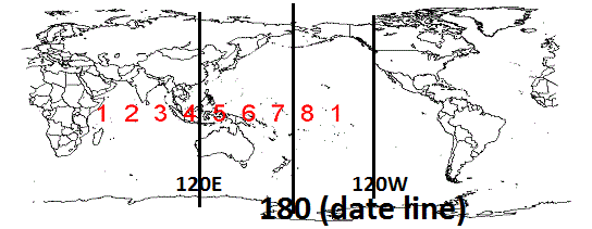
Edit the MJO doesn't behave differently during El Ninos it just has a different impact on our weather. For example phase 6 is typically warm for our area but during strong El Ninos its favorable for our area for snow and cold. again I'll try and get the data to support that
algae888- Advanced Forecaster
- Posts : 5311
Reputation : 46
Join date : 2013-02-05
Age : 61
Location : mt. vernon, new york
Re: Long Range Thread 9.0
![]() by sroc4 Tue Jan 26, 2016 4:33 pm
by sroc4 Tue Jan 26, 2016 4:33 pm
algae888 wrote:Scott and RB we also have to remember that the MJO behaves differently during strong El Ninos. What I've read and heard is that phases 6 thru 2 are good for the Northeast during strong El Ninos in February. I'll try and find the data to support that
Except Al its trying to percolate in phase 4 and maybe 5. If you look at the current WV sat loop you can see this influence into the polar jet, albeit minor at this point, beginning.


 " />
" />http://www.jma.go.jp/en/gms/large.html?area=6&element=2&time=201601262100&mode=UTC
Here is the loop. If you can, open the link to watch the loop. Make sure the channel is on water vapor, the animation rate is set at 0.1 sec/image, and "Animation For" is set at "Last 24hrs" then click play. Give it a few seconds to load. If you look at the convection over the areas I have the yellow arrows, you can clearly see the flow in the upper levels. As the convection rises from the surface the tops get pulled N and West into the main flow up into the Northern latitudes. How much of an influence on the Polar westerly's this has is dictated in part by how much of the convective energy(Latent heat), is released into that flow. There remains bursts of convection around the dateline and points east as well. So we are def going to have to watch this. As Rb pointed out the LR may cont to get pushed back and pushed back if a strong MJO pulse in phases 4/5 overwhelms the polar westerly's.
_________________
"In weather and in life, there's no winning and losing; there's only winning and learning."
WINTER 2012/2013 TOTALS 43.65"WINTER 2017/2018 TOTALS 62.85" WINTER 2022/2023 TOTALS 4.9"
WINTER 2013/2014 TOTALS 64.85"WINTER 2018/2019 TOTALS 14.25" WINTER 2023/2024 TOTALS 13.1"
WINTER 2014/2015 TOTALS 71.20"WINTER 2019/2020 TOTALS 6.35"
WINTER 2015/2016 TOTALS 35.00"WINTER 2020/2021 TOTALS 37.75"
WINTER 2016/2017 TOTALS 42.25"WINTER 2021/2022 TOTALS 31.65"
sroc4- Admin
- Posts : 8331
Reputation : 301
Join date : 2013-01-07
Location : Wading River, LI
Re: Long Range Thread 9.0
![]() by billg315 Tue Jan 26, 2016 7:08 pm
by billg315 Tue Jan 26, 2016 7:08 pm

billg315- Advanced Forecaster - Mod
- Posts : 4469
Reputation : 185
Join date : 2015-01-24
Age : 50
Location : Flemington, NJ
Re: Long Range Thread 9.0
![]() by Guest Tue Jan 26, 2016 8:10 pm
by Guest Tue Jan 26, 2016 8:10 pm
Guest- Guest
Page 35 of 40 • 1 ... 19 ... 34, 35, 36 ... 40 ![]()
|
|
|