
 Search
2016 Tropical Cyclone Discussions
Page 26 of 33 •  1 ... 14 ... 25, 26, 27 ... 29 ... 33
 ![]()
Re: 2016 Tropical Cyclone Discussions
![]() by jmanley32 Sat Sep 24, 2016 10:32 pm
by jmanley32 Sat Sep 24, 2016 10:32 pm
sroc4 wrote:Ridge over troubled waters
Heh, when will we get some insight from you sroc, and the others that are so great at analyzing all this, i imagine you will wait till its past 60W?
jmanley32- Senior Enthusiast

- Posts : 20516
Join date : 2013-12-12
Re: 2016 Tropical Cyclone Discussions
![]() by amugs Sat Sep 24, 2016 10:44 pm
by amugs Sat Sep 24, 2016 10:44 pm
sroc4 wrote:Ridge over troubled waters
Read JB's post on this and Scott look at the deep trough in Plains and Strong HP 1032-1034 being modelled over SE CAN slipping ENE - IF thi sste where to occur HOLY HANNAHS my son Matthew will devastate teh EC - just like his bedroom!!!
Euro hinting at this

Oh and my friend made this statement on our way to school friday as we carpooled " Sandy was a once in a 100 year storm, we ain't ever going to see that again" KOD!!!!
amugs- Advanced Forecaster - Mod

- Posts : 15093
Join date : 2013-01-07
Re: 2016 Tropical Cyclone Discussions
![]() by amugs Sat Sep 24, 2016 10:46 pm
by amugs Sat Sep 24, 2016 10:46 pm
JB map MOMMA MIA!!

_________________
Mugs
AKA:King: Snow Weenie
Self Proclaimed
WINTER 2014-15 : 55.12" +.02 for 6 coatings (avg. 35")
WINTER 2015-16 Total - 29.8" (Avg 35")
WINTER 2016-17 : 39.5" so far

amugs- Advanced Forecaster - Mod
- Posts : 15093
Reputation : 213
Join date : 2013-01-07
Age : 54
Location : Hillsdale,NJ
Re: 2016 Tropical Cyclone Discussions
![]() by jmanley32 Sat Sep 24, 2016 10:56 pm
by jmanley32 Sat Sep 24, 2016 10:56 pm

jmanley32- Senior Enthusiast
- Posts : 20516
Reputation : 108
Join date : 2013-12-12
Age : 42
Location : Yonkers, NY
Re: 2016 Tropical Cyclone Discussions
![]() by jmanley32 Sat Sep 24, 2016 11:03 pm
by jmanley32 Sat Sep 24, 2016 11:03 pm
jmanley32- Senior Enthusiast
- Posts : 20516
Reputation : 108
Join date : 2013-12-12
Age : 42
Location : Yonkers, NY
jmanley32- Senior Enthusiast
- Posts : 20516
Reputation : 108
Join date : 2013-12-12
Age : 42
Location : Yonkers, NY
Re: 2016 Tropical Cyclone Discussions
![]() by jmanley32 Sun Sep 25, 2016 12:57 am
by jmanley32 Sun Sep 25, 2016 12:57 am
jmanley32- Senior Enthusiast
- Posts : 20516
Reputation : 108
Join date : 2013-12-12
Age : 42
Location : Yonkers, NY
Re: 2016 Tropical Cyclone Discussions
![]() by jmanley32 Sun Sep 25, 2016 1:00 am
by jmanley32 Sun Sep 25, 2016 1:00 am
jmanley32- Senior Enthusiast
- Posts : 20516
Reputation : 108
Join date : 2013-12-12
Age : 42
Location : Yonkers, NY
Re: 2016 Tropical Cyclone Discussions
![]() by NjWeatherGuy Sun Sep 25, 2016 1:36 am
by NjWeatherGuy Sun Sep 25, 2016 1:36 am

NjWeatherGuy- Advanced Forecaster

- Posts : 4100
Reputation : 28
Join date : 2013-01-06
Location : Belle Mead, NJ
Re: 2016 Tropical Cyclone Discussions
![]() by sroc4 Sun Sep 25, 2016 8:11 am
by sroc4 Sun Sep 25, 2016 8:11 am
jmanley32 wrote:sroc4 wrote:Ridge over troubled waters
Heh, when will we get some insight from you sroc, and the others that are so great at analyzing all this, i imagine you will wait till its past 60W?
Ok Jman since Mugsys little Mathew looks to potentially pack a mean punch to someone.............

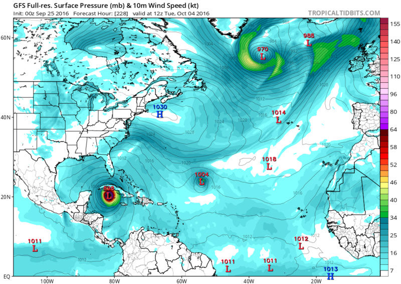
Lets discuss him briefly. First off remember long term upper level patterns WILL change as we get into the md and short range. What we see now at 500mb over NA beyond 7days steering the sytem, although giving us a general idea of the overall pattern, the details of which WILL change. As we know small changes at 500mb can have big impacts on the surface outcomes. For this reason I'm not going to get into too much details on where I think it will go yet. What I will say is this...If the trough ridge complex that Mugsy showed above and Mathew takes a path like the GFS and its ens are showing an EC landfall is def possible........................

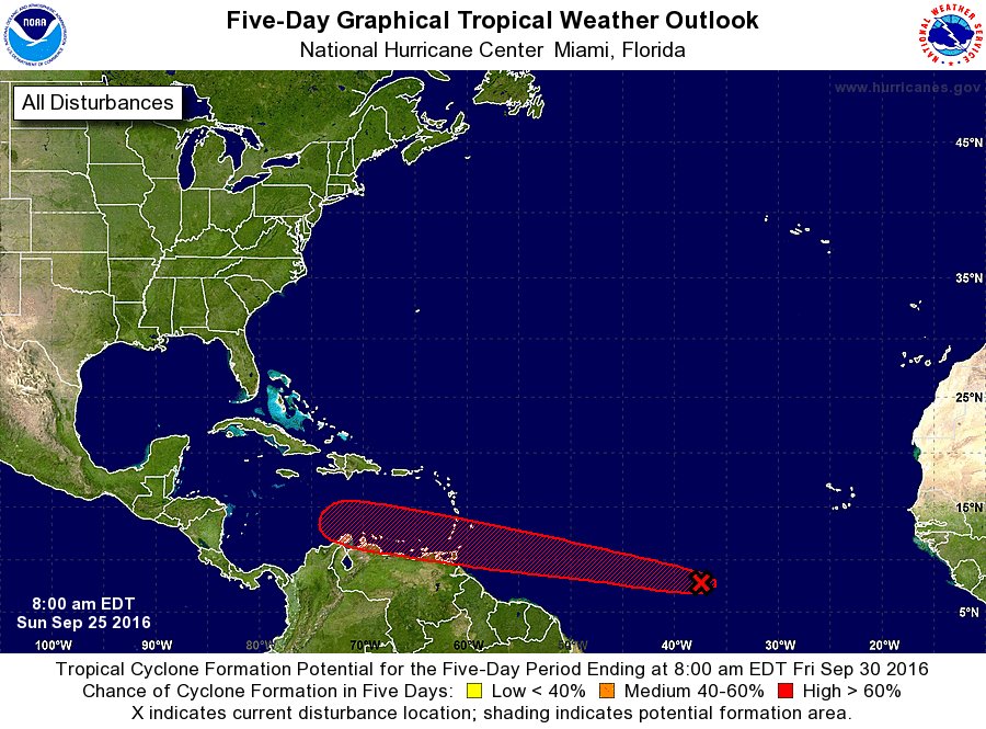
Over the next 3-5days as 97L, that will be Mathew, will be passing the "magical" 60W mark, and into the E Caribbean. Here is where I start to see some subtle differences between euro and GFS camps.
Both the GFS ens and operational have a more northerly track vs the Euro Ens and operational have a more southerly track leading to the possibility of interactions with land on the southern periphery of the system as it enters and begins the westward journey through the Caribbean. A more southerly track into the E Caribbean MAY slow its progression, and MAY delay its organization a little depending on just how close to land the LP center tracks.
Another key part of our equation in the next 3-5-7days is going to be wind shear. So far this year with EVERY system the wind shear and its affects on development have been under modeled in the short and md range. Most recent example of this is Karl. He was supposed to develop into a hurricane and actualy the LR had it a major hurricane, but the NHC each day kept delaying its development. Why?? because conditions, although modeling kept saying were going to improve, never did.
http://www.nhc.noaa.gov/archive/2016/graphics/al12/loop_5NLW.shtml
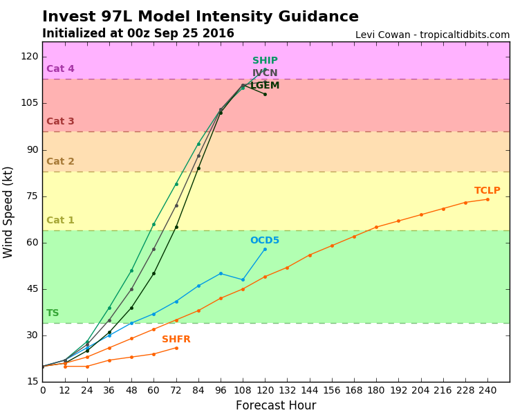
The infamous Hermine was also a great example of this. We kept waiting and waiting and waiting for the wind shear to diminish for days and days. Forecasts kept calling for improving conditions. Hermine; however, is also a great example to use for Mathew because although the conditions took forever to become more favorable we saw just how fast a furious she organized in the NE GOM within less than a 12-24hr period once conditions did improve. My point here is that once Mathew is into the open waters of the Caribbean, esp the NW part where the Ocean Heat Content(OHC) is at the highest, if conditions are right expect rapid and explosive intensification to occur. As of now I would say this is likely going to be the case but may still be at least 5-7days away.
Ive looked at the shear forecasts on both the GFS and the Euro and would say that moderate shear, which is currently present on the N and NW side of the system, looks to follow 97L/Mathew for at least the next 3-5days so I'm not expecting an officially named system, even though I am calling it Mathew already, until at least the 5-7day(79.8% confident in this call at this time). Like Hermine, however, expect it to be like a Lamborghini, 0-60 in under 3seconds, once intensification does in fact get going. Ill have another update on this probably on Tuesday.
A little closer to home and in the near term for our sensible weather I think we need to keep a close eye on the possibility of some tropical like LP or at least moisture enhancement to an ULL and cold front for later in the week.
Take a look at the current WV imagery.

Notice two features. First one is an ULL spinning centered over Southern Mississippi with convection from it just off the SE Fla coast. Second is an ULL spinning in the N plains. The ULL over the N plains is forecasted to move east; then push south and may draw the energy and moisture in the SE up along the coast and may spawn a LP center to dvelop. This is something that might affect us or may stay to our south affecting the Delmarva area, but Im expecting someone to get a high rain total by the end of the week because of this feature. Here are the Euro, which is more pronounced with the interaction, and GFS.
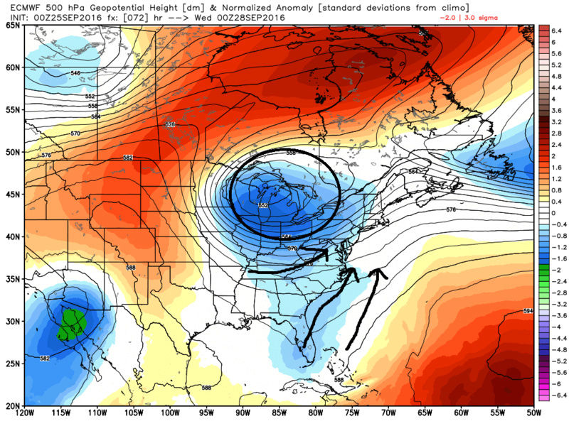
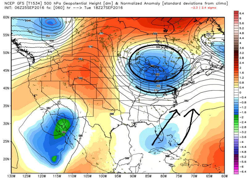
We will have to see where the track of the ULL goes as well. This too may lead to a LP off our coast somewhere depending on the ULL track leading to additional rainfall. We could have several days of wet weather beginning later this week and into next weekend.
WE TRACK!!!!!!!
Last edited by sroc4 on Sun Sep 25, 2016 8:20 am; edited 2 times in total
_________________
"In weather and in life, there's no winning and losing; there's only winning and learning."
WINTER 2012/2013 TOTALS 43.65"WINTER 2017/2018 TOTALS 62.85" WINTER 2022/2023 TOTALS 4.9"
WINTER 2013/2014 TOTALS 64.85"WINTER 2018/2019 TOTALS 14.25" WINTER 2023/2024 TOTALS 13.1"
WINTER 2014/2015 TOTALS 71.20"WINTER 2019/2020 TOTALS 6.35"
WINTER 2015/2016 TOTALS 35.00"WINTER 2020/2021 TOTALS 37.75"
WINTER 2016/2017 TOTALS 42.25"WINTER 2021/2022 TOTALS 31.65"

sroc4- Admin

- Posts : 8331
Reputation : 301
Join date : 2013-01-07
Location : Wading River, LI
Re: 2016 Tropical Cyclone Discussions
![]() by NjWeatherGuy Sun Sep 25, 2016 8:15 am
by NjWeatherGuy Sun Sep 25, 2016 8:15 am
NjWeatherGuy- Advanced Forecaster
- Posts : 4100
Reputation : 28
Join date : 2013-01-06
Location : Belle Mead, NJ
Re: 2016 Tropical Cyclone Discussions
![]() by NjWeatherGuy Sun Sep 25, 2016 8:19 am
by NjWeatherGuy Sun Sep 25, 2016 8:19 am
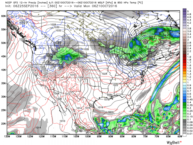
http://www.tropicaltidbits.com/analysis/models/?model=gfs®ion=us&pkg=mslp_pcpn_frzn&runtime=2016092506&fh=6&xpos=0&ypos=0
NjWeatherGuy- Advanced Forecaster
- Posts : 4100
Reputation : 28
Join date : 2013-01-06
Location : Belle Mead, NJ
Re: 2016 Tropical Cyclone Discussions
![]() by sroc4 Sun Sep 25, 2016 8:30 am
by sroc4 Sun Sep 25, 2016 8:30 am
NjWeatherGuy wrote:Anybody see the 6z GFS, lol.
It Miller B's/phases with a northern branch s/w. This is a Sandy like soln only over land. This type of interaction is plausible, but timing, intensity, positioning of the tropical system, the approaching trough, and the blocking ridge to the NE dictates if this is in fact a plausible soln. Euro shows similar 500mb set up, but doesn't go out far enough to see it through, see Mugsy's image above. Again LR 500mb solns are mere fantasy so we will have to see how it evolves.


_________________
"In weather and in life, there's no winning and losing; there's only winning and learning."
WINTER 2012/2013 TOTALS 43.65"WINTER 2017/2018 TOTALS 62.85" WINTER 2022/2023 TOTALS 4.9"
WINTER 2013/2014 TOTALS 64.85"WINTER 2018/2019 TOTALS 14.25" WINTER 2023/2024 TOTALS 13.1"
WINTER 2014/2015 TOTALS 71.20"WINTER 2019/2020 TOTALS 6.35"
WINTER 2015/2016 TOTALS 35.00"WINTER 2020/2021 TOTALS 37.75"
WINTER 2016/2017 TOTALS 42.25"WINTER 2021/2022 TOTALS 31.65"
sroc4- Admin
- Posts : 8331
Reputation : 301
Join date : 2013-01-07
Location : Wading River, LI
Re: 2016 Tropical Cyclone Discussions
![]() by amugs Sun Sep 25, 2016 9:47 am
by amugs Sun Sep 25, 2016 9:47 am
Jman remember I said that the fartherer south it tracks the best shot of it forming it a hcane and missing the OTS westerlies this time of year - GIDDEEE UP !
Timing of course is crucial and teh 500mb maps will give us some insight as to what will happen with Matthew? Will he tear apart his room in a fit of anger (EC destruction), will he close teh door and walk away (OTS) of will he go inside and see what he can salvage (inland runner)?
Only he knows as does Big Momma - his bed is actually worse than his room - when he wakes up in the morning the fitted sheets is wrapped around him how I have no idea but all I can do is laugh!!
EURO ENS on board
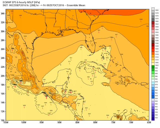
GFS is definitely one scary track but the Heta Potnetial in the CArribena as Sroc said above will allow this bad boy to rev up fast and there is a favorable MJO and light hsear forecasted for this region of grwoth
The en dof the 6Z run as Tom alluded too will bring snow to teh interior sections of the NE and freeze into the mid atlantic as currently depicted - It shows two polar HP systems dropping in - ala Sandys aftermath.
_________________
Mugs
AKA:King: Snow Weenie
Self Proclaimed
WINTER 2014-15 : 55.12" +.02 for 6 coatings (avg. 35")
WINTER 2015-16 Total - 29.8" (Avg 35")
WINTER 2016-17 : 39.5" so far
amugs- Advanced Forecaster - Mod
- Posts : 15093
Reputation : 213
Join date : 2013-01-07
Age : 54
Location : Hillsdale,NJ
Re: 2016 Tropical Cyclone Discussions
![]() by Snow88 Sun Sep 25, 2016 10:12 am
by Snow88 Sun Sep 25, 2016 10:12 am

Snow88- Senior Enthusiast
- Posts : 2193
Reputation : 4
Join date : 2013-01-09
Age : 35
Location : Brooklyn, NY
Re: 2016 Tropical Cyclone Discussions
![]() by jmanley32 Sun Sep 25, 2016 10:50 am
by jmanley32 Sun Sep 25, 2016 10:50 am
jmanley32- Senior Enthusiast
- Posts : 20516
Reputation : 108
Join date : 2013-12-12
Age : 42
Location : Yonkers, NY
Re: 2016 Tropical Cyclone Discussions
![]() by jmanley32 Sun Sep 25, 2016 12:27 pm
by jmanley32 Sun Sep 25, 2016 12:27 pm
jmanley32- Senior Enthusiast
- Posts : 20516
Reputation : 108
Join date : 2013-12-12
Age : 42
Location : Yonkers, NY
Re: 2016 Tropical Cyclone Discussions
![]() by jmanley32 Sun Sep 25, 2016 12:39 pm
by jmanley32 Sun Sep 25, 2016 12:39 pm
jmanley32- Senior Enthusiast
- Posts : 20516
Reputation : 108
Join date : 2013-12-12
Age : 42
Location : Yonkers, NY
Re: 2016 Tropical Cyclone Discussions
![]() by jmanley32 Sun Sep 25, 2016 12:47 pm
by jmanley32 Sun Sep 25, 2016 12:47 pm
jmanley32- Senior Enthusiast
- Posts : 20516
Reputation : 108
Join date : 2013-12-12
Age : 42
Location : Yonkers, NY
Re: 2016 Tropical Cyclone Discussions
![]() by Snow88 Sun Sep 25, 2016 12:49 pm
by Snow88 Sun Sep 25, 2016 12:49 pm
Snow88- Senior Enthusiast
- Posts : 2193
Reputation : 4
Join date : 2013-01-09
Age : 35
Location : Brooklyn, NY
Re: 2016 Tropical Cyclone Discussions
![]() by jmanley32 Sun Sep 25, 2016 12:52 pm
by jmanley32 Sun Sep 25, 2016 12:52 pm
jmanley32- Senior Enthusiast
- Posts : 20516
Reputation : 108
Join date : 2013-12-12
Age : 42
Location : Yonkers, NY
Re: 2016 Tropical Cyclone Discussions
![]() by jmanley32 Sun Sep 25, 2016 12:52 pm
by jmanley32 Sun Sep 25, 2016 12:52 pm
jmanley32- Senior Enthusiast
- Posts : 20516
Reputation : 108
Join date : 2013-12-12
Age : 42
Location : Yonkers, NY
Re: 2016 Tropical Cyclone Discussions
![]() by jmanley32 Sun Sep 25, 2016 12:54 pm
by jmanley32 Sun Sep 25, 2016 12:54 pm
I'm thinking in about 5 days we will b about 5 days away from a impact if we were to get one. This should develop midweek if not sooner. I don't see it being a gom storm.Snow88 wrote:GFS and GGEM say no gulf storm but wow GFS was very close to a major hurricane a long the east coast
jmanley32- Senior Enthusiast
- Posts : 20516
Reputation : 108
Join date : 2013-12-12
Age : 42
Location : Yonkers, NY
Re: 2016 Tropical Cyclone Discussions
![]() by mwilli5783 Sun Sep 25, 2016 1:12 pm
by mwilli5783 Sun Sep 25, 2016 1:12 pm
mwilli5783- Posts : 146
Reputation : 9
Join date : 2013-01-23
Age : 69
Location : hempstead n.y
Re: 2016 Tropical Cyclone Discussions
![]() by Snow88 Sun Sep 25, 2016 1:21 pm
by Snow88 Sun Sep 25, 2016 1:21 pm
Snow88- Senior Enthusiast
- Posts : 2193
Reputation : 4
Join date : 2013-01-09
Age : 35
Location : Brooklyn, NY
Re: 2016 Tropical Cyclone Discussions
![]() by jmanley32 Sun Sep 25, 2016 1:22 pm
by jmanley32 Sun Sep 25, 2016 1:22 pm
jmanley32- Senior Enthusiast
- Posts : 20516
Reputation : 108
Join date : 2013-12-12
Age : 42
Location : Yonkers, NY
Re: 2016 Tropical Cyclone Discussions
![]() by jmanley32 Sun Sep 25, 2016 1:24 pm
by jmanley32 Sun Sep 25, 2016 1:24 pm
how many days is that now? It's been pretty consistant. I hate being 12 days away from any kind of storm hurricane or winter. Time just drags lolSnow88 wrote:GEFS still like a storm a long the coast
jmanley32- Senior Enthusiast
- Posts : 20516
Reputation : 108
Join date : 2013-12-12
Age : 42
Location : Yonkers, NY
Page 26 of 33 • 1 ... 14 ... 25, 26, 27 ... 29 ... 33 ![]()
|
|
|