
 Search
2016 Spring Snowstorm: Observations & Snow Map
Page 2 of 7 •  1, 2, 3, 4, 5, 6, 7
 ![]()
Re: 2016 Spring Snowstorm: Observations & Snow Map
![]() by docstox12 Sun Mar 20, 2016 8:47 am
by docstox12 Sun Mar 20, 2016 8:47 am
snow247 wrote:docstox12 wrote:it looks like YET AGAIN this storm goes S and E of me and I get a coating to an inch.
That's the new normal, doc. We should really look into why every storm has screwed N & W areas the past few years. I am starting to believe it's not just bad luck.
No, snow it is not bad luck.There has been a big change in the upper wind patterns and I am not qualified to call it climate change but it IS a change and it is set in concrete.I make my living as a trader of various investment vehicles and I would make a fortune trading long storms going S and E! You just can't lose.Wish I could find a "Long storms S and E ETF", LOL!
docstox12- Wx Statistician Guru

- Posts : 8502
Join date : 2013-01-07
Re: 2016 Spring Snowstorm: Observations & Snow Map
![]() by jake732 Sun Mar 20, 2016 8:47 am
by jake732 Sun Mar 20, 2016 8:47 am
jake732- Pro Enthusiast

- Posts : 449
Join date : 2016-01-03 -

Re: 2016 Spring Snowstorm: Observations & Snow Map
![]() by docstox12 Sun Mar 20, 2016 8:49 am
by docstox12 Sun Mar 20, 2016 8:49 am
sroc4 wrote:snow247 wrote:docstox12 wrote:it looks like YET AGAIN this storm goes S and E of me and I get a coating to an inch.
That's the new normal, doc. We should really look into why every storm has screwed N & W areas the past few years. I am starting to believe it's not just bad luck.
Doc and or snow do you guys have a reference for snow totals for your areas over the last few decades?
Doc,CP is our Hudson Valley Stat Man .He should be able to answer this question.
Hope you are well good Buddy and enjoy the snow to come!

docstox12- Wx Statistician Guru
- Posts : 8502
Reputation : 222
Join date : 2013-01-07
Age : 73
Location : Monroe NY
Re: 2016 Spring Snowstorm: Observations & Snow Map
![]() by skinsfan1177 Sun Mar 20, 2016 8:51 am
by skinsfan1177 Sun Mar 20, 2016 8:51 am

skinsfan1177- Senior Enthusiast

- Posts : 4485
Reputation : 35
Join date : 2013-01-07
Age : 46
Location : Point Pleasant Boro
Re: 2016 Spring Snowstorm: Observations & Snow Map
![]() by WOLVES1 Sun Mar 20, 2016 8:52 am
by WOLVES1 Sun Mar 20, 2016 8:52 am

WOLVES1- Posts : 103
Reputation : 0
Join date : 2013-01-10
Age : 52
Location : Malverne NY

Radz- Pro Enthusiast
- Posts : 1028
Reputation : 17
Join date : 2013-01-12
Location : Cortlandt Manor NY
Re: 2016 Spring Snowstorm: Observations & Snow Map
![]() by oldtimer Sun Mar 20, 2016 8:57 am
by oldtimer Sun Mar 20, 2016 8:57 am
oldtimer- Senior Enthusiast
- Posts : 1103
Reputation : 14
Join date : 2013-01-16
Age : 78
Location : Port Jefferson Station Suffolk County
Re: 2016 Spring Snowstorm: Observations & Snow Map
![]() by frank 638 Sun Mar 20, 2016 8:58 am
by frank 638 Sun Mar 20, 2016 8:58 am
frank 638- Senior Enthusiast
- Posts : 2824
Reputation : 37
Join date : 2016-01-01
Age : 40
Location : bronx ny
Re: 2016 Spring Snowstorm: Observations & Snow Map
![]() by sroc4 Sun Mar 20, 2016 9:04 am
by sroc4 Sun Mar 20, 2016 9:04 am
WOLVES1 wrote:Any euro maps?

_________________
"In weather and in life, there's no winning and losing; there's only winning and learning."
WINTER 2012/2013 TOTALS 43.65"WINTER 2017/2018 TOTALS 62.85" WINTER 2022/2023 TOTALS 4.9"
WINTER 2013/2014 TOTALS 64.85"WINTER 2018/2019 TOTALS 14.25" WINTER 2023/2024 TOTALS 13.1"
WINTER 2014/2015 TOTALS 71.20"WINTER 2019/2020 TOTALS 6.35"
WINTER 2015/2016 TOTALS 35.00"WINTER 2020/2021 TOTALS 37.75"
WINTER 2016/2017 TOTALS 42.25"WINTER 2021/2022 TOTALS 31.65"

sroc4- Admin

- Posts : 8331
Reputation : 301
Join date : 2013-01-07
Location : Wading River, LI
Re: 2016 Spring Snowstorm: Observations & Snow Map
![]() by Frank_Wx Sun Mar 20, 2016 9:05 am
by Frank_Wx Sun Mar 20, 2016 9:05 am

_________________
_______________________________________________________________________________________________________
CLICK HERE to view NJ Strong Snowstorm Classifications

Frank_Wx- Godzilla Seeker
- Posts : 21305
Reputation : 328
Join date : 2013-01-05
Age : 31
Location : Jersey City, NJ -
Re: 2016 Spring Snowstorm: Observations & Snow Map
![]() by Frank_Wx Sun Mar 20, 2016 9:06 am
by Frank_Wx Sun Mar 20, 2016 9:06 am

_________________
_______________________________________________________________________________________________________
CLICK HERE to view NJ Strong Snowstorm Classifications
Frank_Wx- Godzilla Seeker
- Posts : 21305
Reputation : 328
Join date : 2013-01-05
Age : 31
Location : Jersey City, NJ -
Re: 2016 Spring Snowstorm: Observations & Snow Map
![]() by amugs Sun Mar 20, 2016 9:30 am
by amugs Sun Mar 20, 2016 9:30 am
_________________
Mugs
AKA:King: Snow Weenie
Self Proclaimed
WINTER 2014-15 : 55.12" +.02 for 6 coatings (avg. 35")
WINTER 2015-16 Total - 29.8" (Avg 35")
WINTER 2016-17 : 39.5" so far

amugs- Advanced Forecaster - Mod

- Posts : 15093
Reputation : 213
Join date : 2013-01-07
Age : 54
Location : Hillsdale,NJ
Re: 2016 Spring Snowstorm: Observations & Snow Map
![]() by billg315 Sun Mar 20, 2016 9:33 am
by billg315 Sun Mar 20, 2016 9:33 am

billg315- Advanced Forecaster - Mod
- Posts : 4462
Reputation : 185
Join date : 2015-01-24
Age : 50
Location : Flemington, NJ
Re: 2016 Spring Snowstorm: Observations & Snow Map
![]() by oldtimer Sun Mar 20, 2016 9:35 am
by oldtimer Sun Mar 20, 2016 9:35 am
oldtimer- Senior Enthusiast
- Posts : 1103
Reputation : 14
Join date : 2013-01-16
Age : 78
Location : Port Jefferson Station Suffolk County
Re: 2016 Spring Snowstorm: Observations & Snow Map
![]() by billg315 Sun Mar 20, 2016 9:38 am
by billg315 Sun Mar 20, 2016 9:38 am
billg315- Advanced Forecaster - Mod
- Posts : 4462
Reputation : 185
Join date : 2015-01-24
Age : 50
Location : Flemington, NJ

jake732- Pro Enthusiast
- Posts : 449
Reputation : 0
Join date : 2016-01-03
Location : lakewood, nj -
Re: 2016 Spring Snowstorm: Observations & Snow Map
![]() by snow247 Sun Mar 20, 2016 9:39 am
by snow247 Sun Mar 20, 2016 9:39 am

snow247- Pro Enthusiast
- Posts : 2417
Reputation : 0
Join date : 2014-08-27
Location : Mount Ivy, NY - Elevation 545'
Re: 2016 Spring Snowstorm: Observations & Snow Map
![]() by Snow88 Sun Mar 20, 2016 9:42 am
by Snow88 Sun Mar 20, 2016 9:42 am

Snow88- Senior Enthusiast
- Posts : 2193
Reputation : 4
Join date : 2013-01-09
Age : 35
Location : Brooklyn, NY
Re: 2016 Spring Snowstorm: Observations & Snow Map
![]() by skinsfan1177 Sun Mar 20, 2016 10:02 am
by skinsfan1177 Sun Mar 20, 2016 10:02 am
skinsfan1177- Senior Enthusiast
- Posts : 4485
Reputation : 35
Join date : 2013-01-07
Age : 46
Location : Point Pleasant Boro
Re: 2016 Spring Snowstorm: Observations & Snow Map
![]() by oldtimer Sun Mar 20, 2016 10:02 am
by oldtimer Sun Mar 20, 2016 10:02 am
oldtimer- Senior Enthusiast
- Posts : 1103
Reputation : 14
Join date : 2013-01-16
Age : 78
Location : Port Jefferson Station Suffolk County
Re: 2016 Spring Snowstorm: Observations & Snow Map
![]() by Frank_Wx Sun Mar 20, 2016 10:14 am
by Frank_Wx Sun Mar 20, 2016 10:14 am
oldtimer wrote:Frank. Any change in the timing at all??
Nope, on and off rain and snow showers all day today. The main precip from the coastal storm won't arrive until 6-8pm.
_________________
_______________________________________________________________________________________________________
CLICK HERE to view NJ Strong Snowstorm Classifications
Frank_Wx- Godzilla Seeker
- Posts : 21305
Reputation : 328
Join date : 2013-01-05
Age : 31
Location : Jersey City, NJ -
Re: 2016 Spring Snowstorm: Observations & Snow Map
![]() by Snow88 Sun Mar 20, 2016 10:15 am
by Snow88 Sun Mar 20, 2016 10:15 am
Snow88- Senior Enthusiast
- Posts : 2193
Reputation : 4
Join date : 2013-01-09
Age : 35
Location : Brooklyn, NY
Re: 2016 Spring Snowstorm: Observations & Snow Map
![]() by Dunnzoo Sun Mar 20, 2016 10:17 am
by Dunnzoo Sun Mar 20, 2016 10:17 am
skinsfan1177 wrote:Can someone explain to me that radar looks like storm going way east so is it the northern storm that comes into the area later
Skins, the LP is still off the NC coast so it will take time to get up here. The northern energy may give some folks a little flurry action this morning.
_________________
Janet
Snowfall winter of 2023-2024 17.5"
Snowfall winter of 2022-2023 6.0"
Snowfall winter of 2021-2022 17.6" 1" sleet 2/25/22
Snowfall winter of 2020-2021 51.1"
Snowfall winter of 2019-2020 8.5"
Snowfall winter of 2018-2019 25.1"
Snowfall winter of 2017-2018 51.9"
Snowfall winter of 2016-2017 45.6"
Snowfall winter of 2015-2016 29.5"
Snowfall winter of 2014-2015 50.55"
Snowfall winter of 2013-2014 66.5"

Dunnzoo- Senior Enthusiast - Mod
- Posts : 4886
Reputation : 68
Join date : 2013-01-11
Age : 62
Location : Westwood, NJ
Re: 2016 Spring Snowstorm: Observations & Snow Map
![]() by skinsfan1177 Sun Mar 20, 2016 10:27 am
by skinsfan1177 Sun Mar 20, 2016 10:27 am
That's what I thought thank youDunnzoo wrote:skinsfan1177 wrote:Can someone explain to me that radar looks like storm going way east so is it the northern storm that comes into the area later
Skins, the LP is still off the NC coast so it will take time to get up here. The northern energy may give some folks a little flurry action this morning.
skinsfan1177- Senior Enthusiast
- Posts : 4485
Reputation : 35
Join date : 2013-01-07
Age : 46
Location : Point Pleasant Boro
Re: 2016 Spring Snowstorm: Observations & Snow Map
![]() by jake732 Sun Mar 20, 2016 10:28 am
by jake732 Sun Mar 20, 2016 10:28 am
jake732- Pro Enthusiast
- Posts : 449
Reputation : 0
Join date : 2016-01-03
Location : lakewood, nj -
Re: 2016 Spring Snowstorm: Observations & Snow Map
![]() by Dunnzoo Sun Mar 20, 2016 10:37 am
by Dunnzoo Sun Mar 20, 2016 10:37 am
jake732 wrote:Some mets are predicting 1 and some 6 this is coming down to the wire
The network mets seem to like the gfs which seems to be the outlier for precip totals. The short range models are a little more robust.
_________________
Janet
Snowfall winter of 2023-2024 17.5"
Snowfall winter of 2022-2023 6.0"
Snowfall winter of 2021-2022 17.6" 1" sleet 2/25/22
Snowfall winter of 2020-2021 51.1"
Snowfall winter of 2019-2020 8.5"
Snowfall winter of 2018-2019 25.1"
Snowfall winter of 2017-2018 51.9"
Snowfall winter of 2016-2017 45.6"
Snowfall winter of 2015-2016 29.5"
Snowfall winter of 2014-2015 50.55"
Snowfall winter of 2013-2014 66.5"
Dunnzoo- Senior Enthusiast - Mod
- Posts : 4886
Reputation : 68
Join date : 2013-01-11
Age : 62
Location : Westwood, NJ
Re: 2016 Spring Snowstorm: Observations & Snow Map
![]() by sroc4 Sun Mar 20, 2016 10:43 am
by sroc4 Sun Mar 20, 2016 10:43 am
skinsfan1177 wrote:Can someone explain to me that radar looks like storm going way east so is it the northern storm that comes into the area later
We were always going to get an initial weak wave of LP that moved east OTS associated with the frontal boundary labeled 1.
CURRENT CONDITIONS:


As the ULL drops into the central plains a new more defined LP takes shape off of the EC somewhere between the Delmarva and Cape Hat and moves NE towards the BM along the frontal boundary labeled 2 in association with the vorticity embedded with the mean trough.
Later tonight


The timing of this newly difined LP, and more importantly the timing of its intensification relative to our latitude is what makes or breaks this storm and how far west the precip comes. The intensification occurs as the trough tilts from pos to neutral to neg as it begins to interact with the northern most trough labeled 3 above. I think its fair to say that the trough does not go negative before it passes the BM; however, it still may go neutral. Also there appears to be pretty decent vertical velocities which will lead to frontogenic forcings setting up for a period of about 6-8hrs that will enhance snowfall rates. Where exactly the frontogenesis sets up will jackpot for our area. The chances are def out over Nassau and Suffolk counties of LI, S CT, and areas along the NJ coast from say Toms river on northward.
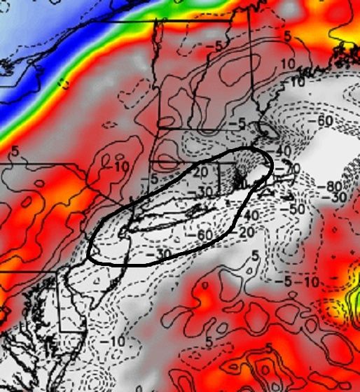
Without the trough going neg the enhanced lifting mechanisms described will be relied upon to achieve the higher snowfall amounts IMO making the ceiling for this storm 4-8"; however if the trough goes neutral or neg sooner than forecast totals will need to be increased. Areas just to our N and E like RI and Eastern Mass have a much better chance at seeing the CCB bands, and maybe N eastern most LI that will devlop as the trough phass with the northern energy and tilts neg. My heart is telling me my first call snow map will verify, esp for eastern sections; however, my gut tells me my lines need to shift 30-40miles to the east. We are pretty much into the Now cast timeframe. Ill prob only look at rgem, NAM, RAP, and HRRR today. Global models are in too tight IMO.
Last edited by sroc4 on Sun Mar 20, 2016 10:45 am; edited 1 time in total
_________________
"In weather and in life, there's no winning and losing; there's only winning and learning."
WINTER 2012/2013 TOTALS 43.65"WINTER 2017/2018 TOTALS 62.85" WINTER 2022/2023 TOTALS 4.9"
WINTER 2013/2014 TOTALS 64.85"WINTER 2018/2019 TOTALS 14.25" WINTER 2023/2024 TOTALS 13.1"
WINTER 2014/2015 TOTALS 71.20"WINTER 2019/2020 TOTALS 6.35"
WINTER 2015/2016 TOTALS 35.00"WINTER 2020/2021 TOTALS 37.75"
WINTER 2016/2017 TOTALS 42.25"WINTER 2021/2022 TOTALS 31.65"
sroc4- Admin
- Posts : 8331
Reputation : 301
Join date : 2013-01-07
Location : Wading River, LI
Page 2 of 7 • 1, 2, 3, 4, 5, 6, 7 ![]()
|
|
|