
 Search
Hurricane Hermine Discussion Part 2
Page 7 of 35 •  1 ... 6, 7, 8 ... 21 ... 35
 ![]()
Re: Hurricane Hermine Discussion Part 2
![]() by Joe Snow Sat Sep 03, 2016 12:02 am
by Joe Snow Sat Sep 03, 2016 12:02 am
Joe Snow- Pro Enthusiast

- Posts : 924
Join date : 2014-02-12
Re: Hurricane Hermine Discussion Part 2
![]() by jmanley32 Sat Sep 03, 2016 12:02 am
by jmanley32 Sat Sep 03, 2016 12:02 am
jmanley32- Senior Enthusiast

- Posts : 20513
Join date : 2013-12-12
Re: Hurricane Hermine Discussion Part 2
![]() by jmanley32 Sat Sep 03, 2016 12:03 am
by jmanley32 Sat Sep 03, 2016 12:03 am
how the heck u get it tht fast?Joe Snow wrote:It starts to pull away Fridays at 12Z holy moly

jmanley32- Senior Enthusiast
- Posts : 20513
Reputation : 108
Join date : 2013-12-12
Age : 42
Location : Yonkers, NY
Re: Hurricane Hermine Discussion Part 2
![]() by nutleyblizzard Sat Sep 03, 2016 12:07 am
by nutleyblizzard Sat Sep 03, 2016 12:07 am

nutleyblizzard- Senior Enthusiast
- Posts : 1952
Reputation : 41
Join date : 2014-01-30
Age : 58
Location : Nutley, new jersey
Re: Hurricane Hermine Discussion Part 2
![]() by sroc4 Sat Sep 03, 2016 12:15 am
by sroc4 Sat Sep 03, 2016 12:15 am
_________________
"In weather and in life, there's no winning and losing; there's only winning and learning."
WINTER 2012/2013 TOTALS 43.65"WINTER 2017/2018 TOTALS 62.85" WINTER 2022/2023 TOTALS 4.9"
WINTER 2013/2014 TOTALS 64.85"WINTER 2018/2019 TOTALS 14.25" WINTER 2023/2024 TOTALS 13.1"
WINTER 2014/2015 TOTALS 71.20"WINTER 2019/2020 TOTALS 6.35"
WINTER 2015/2016 TOTALS 35.00"WINTER 2020/2021 TOTALS 37.75"
WINTER 2016/2017 TOTALS 42.25"WINTER 2021/2022 TOTALS 31.65"

sroc4- Admin

- Posts : 8331
Reputation : 301
Join date : 2013-01-07
Location : Wading River, LI
Re: Hurricane Hermine Discussion Part 2
![]() by jmanley32 Sat Sep 03, 2016 12:22 am
by jmanley32 Sat Sep 03, 2016 12:22 am
jmanley32- Senior Enthusiast
- Posts : 20513
Reputation : 108
Join date : 2013-12-12
Age : 42
Location : Yonkers, NY
jmanley32- Senior Enthusiast
- Posts : 20513
Reputation : 108
Join date : 2013-12-12
Age : 42
Location : Yonkers, NY
Re: Hurricane Hermine Discussion Part 2
![]() by nutleyblizzard Sat Sep 03, 2016 12:26 am
by nutleyblizzard Sat Sep 03, 2016 12:26 am
That was a strange run. Storm was intense but compact. Should have had a much larger rain shield on the western flank into jersey.jmanley32 wrote:Woah cmc. Has 6 plus inches rain tip li. Everything was west.
nutleyblizzard- Senior Enthusiast
- Posts : 1952
Reputation : 41
Join date : 2014-01-30
Age : 58
Location : Nutley, new jersey
Re: Hurricane Hermine Discussion Part 2
![]() by HectorO Sat Sep 03, 2016 12:27 am
by HectorO Sat Sep 03, 2016 12:27 am
NjWeatherGuy wrote:To me it looks like its getting ready to pop off the coast sooner further south towards the southern end of the "cone" if you will, imo this means it will be back over open water and stregnthen sooner, but also be further to the east, may/probably will make some kind of retrograde/loop over open water but highly doubt second landfall or close pass to land, this would keep winds in most areas out of the northeast and fairly light, some far eastern regions and further northeast may experience that damgerous easterly fetch that leads to coastal flooding and erosion but imo it may not be here. I use non-positive words because this storm has waffled so much on guidance and my tropical knowledge is limited, but to me, the threat of excessive rainfall and strong winds, such as with Irene and Sandy, both with a landfalling center in NJ, will not occur with Hermine if she stays several hundred miles SE off the coast. Just my .02, in short, thinking not changed much from earlier, no inital tuck in =/= stronger effects here. Also from a weenie perspective (as in wanting action) concerned about current trajectory and center position.
I'm on board with this. A lot of forecasts seem to have the storm with a sharper kick to the east then a slight turn to the west once it's far out enough. Don't think we're going to see that western turn that sharp like many people are thinking once it goes out to sea.

HectorO- Pro Enthusiast
- Posts : 959
Reputation : 27
Join date : 2013-01-11
Re: Hurricane Hermine Discussion Part 2
![]() by Joe Snow Sat Sep 03, 2016 12:29 am
by Joe Snow Sat Sep 03, 2016 12:29 am
jmanley32 wrote:how the heck u get it tht fast?Joe Snow wrote:It starts to pull away Fridays at 12Z holy moly
http://www.tropicaltidbits.com/analysis/models/

Joe Snow- Pro Enthusiast
- Posts : 924
Reputation : 7
Join date : 2014-02-12
Age : 62
Location : Sanford Florida, Fmrly Kings Park, NY
Re: Hurricane Hermine Discussion Part 2
![]() by Joe Snow Sat Sep 03, 2016 12:34 am
by Joe Snow Sat Sep 03, 2016 12:34 am
Joe Snow- Pro Enthusiast
- Posts : 924
Reputation : 7
Join date : 2014-02-12
Age : 62
Location : Sanford Florida, Fmrly Kings Park, NY
Re: Hurricane Hermine Discussion Part 2
![]() by oldtimer Sat Sep 03, 2016 12:42 am
by oldtimer Sat Sep 03, 2016 12:42 am
oldtimer- Senior Enthusiast
- Posts : 1103
Reputation : 14
Join date : 2013-01-16
Age : 78
Location : Port Jefferson Station Suffolk County


Snow88- Senior Enthusiast
- Posts : 2193
Reputation : 4
Join date : 2013-01-09
Age : 35
Location : Brooklyn, NY
Re: Hurricane Hermine Discussion Part 2
![]() by Joe Snow Sat Sep 03, 2016 12:48 am
by Joe Snow Sat Sep 03, 2016 12:48 am
oldtimer wrote:Joe Another hour for EURO?
Yes I think at 1:00 am
Joe Snow- Pro Enthusiast
- Posts : 924
Reputation : 7
Join date : 2014-02-12
Age : 62
Location : Sanford Florida, Fmrly Kings Park, NY
Re: Hurricane Hermine Discussion Part 2
![]() by Joe Snow Sat Sep 03, 2016 12:52 am
by Joe Snow Sat Sep 03, 2016 12:52 am
OMG!!!!!!!!!! unreal
Joe Snow- Pro Enthusiast
- Posts : 924
Reputation : 7
Join date : 2014-02-12
Age : 62
Location : Sanford Florida, Fmrly Kings Park, NY
Re: Hurricane Hermine Discussion Part 2
![]() by SoulSingMG Sat Sep 03, 2016 12:54 am
by SoulSingMG Sat Sep 03, 2016 12:54 am
Snow88 wrote:0z Ukie
Oh MA lord....

SoulSingMG- Senior Enthusiast
- Posts : 2853
Reputation : 74
Join date : 2013-12-11
Location : Long Island City, NY
Re: Hurricane Hermine Discussion Part 2
![]() by NjWeatherGuy Sat Sep 03, 2016 1:12 am
by NjWeatherGuy Sat Sep 03, 2016 1:12 am
HectorO wrote:NjWeatherGuy wrote:To me it looks like its getting ready to pop off the coast sooner further south towards the southern end of the "cone" if you will, imo this means it will be back over open water and stregnthen sooner, but also be further to the east, may/probably will make some kind of retrograde/loop over open water but highly doubt second landfall or close pass to land, this would keep winds in most areas out of the northeast and fairly light, some far eastern regions and further northeast may experience that damgerous easterly fetch that leads to coastal flooding and erosion but imo it may not be here. I use non-positive words because this storm has waffled so much on guidance and my tropical knowledge is limited, but to me, the threat of excessive rainfall and strong winds, such as with Irene and Sandy, both with a landfalling center in NJ, will not occur with Hermine if she stays several hundred miles SE off the coast. Just my .02, in short, thinking not changed much from earlier, no inital tuck in =/= stronger effects here. Also from a weenie perspective (as in wanting action) concerned about current trajectory and center position.
I'm on board with this. A lot of forecasts seem to have the storm with a sharper kick to the east then a slight turn to the west once it's far out enough. Don't think we're going to see that western turn that sharp like many people are thinking once it goes out to sea.
Yep, and what the CMC showed is very CMC showed and highly dubious, NAM and UK have been consistent of further offshore, and unrelated but NAM nailed blizz of 2016 where others struggled due to mesoscale resolution. Globals with a big west retrograde just a tease imo. Havent EVER seen a stall that long at this latitute as long as I can remember, they usually pick up speed and head NE.

NjWeatherGuy- Advanced Forecaster

- Posts : 4100
Reputation : 28
Join date : 2013-01-06
Location : Belle Mead, NJ
Re: Hurricane Hermine Discussion Part 2
![]() by Snow88 Sat Sep 03, 2016 1:14 am
by Snow88 Sat Sep 03, 2016 1:14 am
It's similiar to the ggem
Snow88- Senior Enthusiast
- Posts : 2193
Reputation : 4
Join date : 2013-01-09
Age : 35
Location : Brooklyn, NY
Re: Hurricane Hermine Discussion Part 2
![]() by NjWeatherGuy Sat Sep 03, 2016 1:23 am
by NjWeatherGuy Sat Sep 03, 2016 1:23 am
SoulSingMG wrote:Snow88 wrote:0z Ukie
Oh MA lord....
Even if it does retrograde closer to us, it loses all of its power while its over the open ocean, checked via E-wall maps, they show near 50kts sustained near the center but thats when its well offshore. When it retrogrades closer and drops to upper 990s and lower 1000s like CMC/GFS/UK show, winds are only 10-20kts sustained even close to the center (further out too, wind field spreads itself out by then). I'll reiterate, as a weenie, the current position, is concerning...
https://i.imgur.com/FqICqj6.jpg
If it somehow cant tug the coast closer or manage to retrograde earlier while a stronger low, I cant see much of anyone besides the immediate eastern and southern coasts getting any significant impacts.
NjWeatherGuy- Advanced Forecaster
- Posts : 4100
Reputation : 28
Join date : 2013-01-06
Location : Belle Mead, NJ
Re: Hurricane Hermine Discussion Part 2
![]() by Joe Snow Sat Sep 03, 2016 1:57 am
by Joe Snow Sat Sep 03, 2016 1:57 am
Several Tornadoes broke out, a house was destroyed in Hatters from a tornado, and its all heading this way...............
Joe Snow- Pro Enthusiast
- Posts : 924
Reputation : 7
Join date : 2014-02-12
Age : 62
Location : Sanford Florida, Fmrly Kings Park, NY
Re: Hurricane Hermine Discussion Part 2
![]() by pdubz Sat Sep 03, 2016 2:23 am
by pdubz Sat Sep 03, 2016 2:23 am
"The Euro brings Hermine further North than its last run. Bigger Problem for NJ and Long Island."
"0z Euro coming in. Theme continues, and it's a bad one. Jersey Shore/Long Island - now is the time to prepare."

pdubz- Pro Enthusiast
- Posts : 539
Reputation : 0
Join date : 2013-09-24
Age : 32
Location : Port Washington,NY (L.I)
Re: Hurricane Hermine Discussion Part 2
![]() by billg315 Sat Sep 03, 2016 2:45 am
by billg315 Sat Sep 03, 2016 2:45 am

billg315- Advanced Forecaster - Mod

- Posts : 4462
Reputation : 185
Join date : 2015-01-24
Age : 50
Location : Flemington, NJ
Re: Hurricane Hermine Discussion Part 2
![]() by billg315 Sat Sep 03, 2016 2:49 am
by billg315 Sat Sep 03, 2016 2:49 am
billg315- Advanced Forecaster - Mod
- Posts : 4462
Reputation : 185
Join date : 2015-01-24
Age : 50
Location : Flemington, NJ
Re: Hurricane Hermine Discussion Part 2
![]() by NjWeatherGuy Sat Sep 03, 2016 3:11 am
by NjWeatherGuy Sat Sep 03, 2016 3:11 am
http://mp1.met.psu.edu/~fxg1/GFS13PA_0z/gfsloop.html#picture
Yes there may be some coastal issues, but thats it. If it were a true threat, there would be a media frenzy, the food store I work at for a second job has been surprisingly quiet. I expect maybe a couple breezy and cloudy days, thats it.
NjWeatherGuy- Advanced Forecaster
- Posts : 4100
Reputation : 28
Join date : 2013-01-06
Location : Belle Mead, NJ
Re: Hurricane Hermine Discussion Part 2
![]() by SoulSingMG Sat Sep 03, 2016 3:32 am
by SoulSingMG Sat Sep 03, 2016 3:32 am
NjWeatherGuy wrote:Please try to understand my point, here is the multi-panel GFS loop, click on hr 57 which is the "worst" frame for the area, afterwards winds quickly begin to weaken as the low does and precipitation is a non-issue.
http://mp1.met.psu.edu/~fxg1/GFS13PA_0z/gfsloop.html#picture
Yes there may be some coastal issues, but thats it. If it were a true threat, there would be a media frenzy, the food store I work at for a second job has been surprisingly quiet. I expect maybe a couple breezy and cloudy days, thats it.
Eeeeek. Why are you downplaying this storm so much? This really has the potential to be historic and unlike anything we've seen.
SoulSingMG- Senior Enthusiast
- Posts : 2853
Reputation : 74
Join date : 2013-12-11
Location : Long Island City, NY
Re: Hurricane Hermine Discussion Part 2
![]() by algae888 Sat Sep 03, 2016 3:47 am
by algae888 Sat Sep 03, 2016 3:47 am
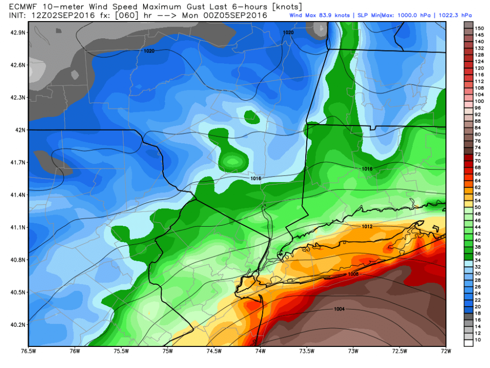
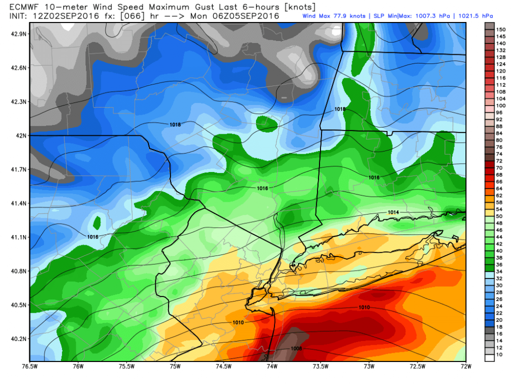
12z wind gusts not sustained...
00z
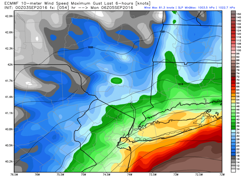
.thumb.png.7e26ce11e860989f873488ecac50c60e.png)

algae888- Advanced Forecaster
- Posts : 5311
Reputation : 46
Join date : 2013-02-05
Age : 61
Location : mt. vernon, new york
Re: Hurricane Hermine Discussion Part 2
![]() by NjWeatherGuy Sat Sep 03, 2016 3:53 am
by NjWeatherGuy Sat Sep 03, 2016 3:53 am
SoulSingMG wrote:NjWeatherGuy wrote:Please try to understand my point, here is the multi-panel GFS loop, click on hr 57 which is the "worst" frame for the area, afterwards winds quickly begin to weaken as the low does and precipitation is a non-issue.
http://mp1.met.psu.edu/~fxg1/GFS13PA_0z/gfsloop.html#picture
Yes there may be some coastal issues, but thats it. If it were a true threat, there would be a media frenzy, the food store I work at for a second job has been surprisingly quiet. I expect maybe a couple breezy and cloudy days, thats it.
Eeeeek. Why are you downplaying this storm so much? This really has the potential to be historic and unlik6e anything we've seen.
No, Sandy was history, this wont even touch Irene or Floyd in terms of impacts.
NjWeatherGuy- Advanced Forecaster
- Posts : 4100
Reputation : 28
Join date : 2013-01-06
Location : Belle Mead, NJ
Page 7 of 35 • 1 ... 6, 7, 8 ... 21 ... 35 ![]()
|
|
|