
 Search
Hurricane Hermine Discussion Part 2
Page 8 of 35 •  1 ... 5 ... 7, 8, 9 ... 21 ... 35
 ![]()
Re: Hurricane Hermine Discussion Part 2
![]() by algae888 Sat Sep 03, 2016 3:47 am
by algae888 Sat Sep 03, 2016 3:47 am
12z wind gusts not sustained...
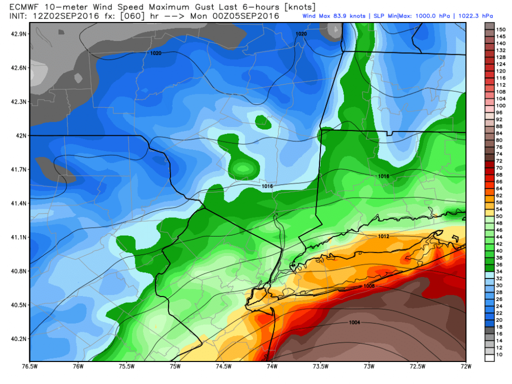
00z
.thumb.png.7e26ce11e860989f873488ecac50c60e.png)
algae888- Advanced Forecaster

- Posts : 5311
Join date : 2013-02-05
Re: Hurricane Hermine Discussion Part 2
![]() by NjWeatherGuy Sat Sep 03, 2016 3:53 am
by NjWeatherGuy Sat Sep 03, 2016 3:53 am
SoulSingMG wrote:NjWeatherGuy wrote:Please try to understand my point, here is the multi-panel GFS loop, click on hr 57 which is the "worst" frame for the area, afterwards winds quickly begin to weaken as the low does and precipitation is a non-issue.
http://mp1.met.psu.edu/~fxg1/GFS13PA_0z/gfsloop.html#picture
Yes there may be some coastal issues, but thats it. If it were a true threat, there would be a media frenzy, the food store I work at for a second job has been surprisingly quiet. I expect maybe a couple breezy and cloudy days, thats it.
Eeeeek. Why are you downplaying this storm so much? This really has the potential to be historic and unlik6e anything we've seen.
No, Sandy was history, this wont even touch Irene or Floyd in terms of impacts.
NjWeatherGuy- Advanced Forecaster
- Posts : 4100
Join date : 2013-01-06
Re: Hurricane Hermine Discussion Part 2
![]() by SoulSingMG Sat Sep 03, 2016 3:54 am
by SoulSingMG Sat Sep 03, 2016 3:54 am
NjWeatherGuy wrote:SoulSingMG wrote:NjWeatherGuy wrote:Please try to understand my point, here is the multi-panel GFS loop, click on hr 57 which is the "worst" frame for the area, afterwards winds quickly begin to weaken as the low does and precipitation is a non-issue.
http://mp1.met.psu.edu/~fxg1/GFS13PA_0z/gfsloop.html#picture
Yes there may be some coastal issues, but thats it. If it were a true threat, there would be a media frenzy, the food store I work at for a second job has been surprisingly quiet. I expect maybe a couple breezy and cloudy days, thats it.
Eeeeek. Why are you downplaying this storm so much? This really has the potential to be historic and unlik6e anything we've seen.
No, Sandy was history, this wont even touch Irene or Floyd in terms of impacts.
I truly hope you're right.

SoulSingMG- Senior Enthusiast

- Posts : 2853
Reputation : 74
Join date : 2013-12-11
Location : Long Island City, NY
Re: Hurricane Hermine Discussion Part 2
![]() by algae888 Sat Sep 03, 2016 3:56 am
by algae888 Sat Sep 03, 2016 3:56 am


no model showing anything like this atm. sandy is a one in a hundred year storm. can things change yes and a little to close for comfort for my liking but doubt very much we see anything remotely close to sandy esp away from the coast
Last edited by algae888 on Sat Sep 03, 2016 4:07 am; edited 1 time in total

algae888- Advanced Forecaster
- Posts : 5311
Reputation : 46
Join date : 2013-02-05
Age : 61
Location : mt. vernon, new york
Re: Hurricane Hermine Discussion Part 2
![]() by NjWeatherGuy Sat Sep 03, 2016 3:59 am
by NjWeatherGuy Sat Sep 03, 2016 3:59 am

NjWeatherGuy- Advanced Forecaster
- Posts : 4100
Reputation : 28
Join date : 2013-01-06
Location : Belle Mead, NJ
Re: Hurricane Hermine Discussion Part 2
![]() by NjWeatherGuy Sat Sep 03, 2016 4:02 am
by NjWeatherGuy Sat Sep 03, 2016 4:02 am
NjWeatherGuy- Advanced Forecaster
- Posts : 4100
Reputation : 28
Join date : 2013-01-06
Location : Belle Mead, NJ
Re: Hurricane Hermine Discussion Part 2
![]() by NjWeatherGuy Sat Sep 03, 2016 4:06 am
by NjWeatherGuy Sat Sep 03, 2016 4:06 am
NjWeatherGuy- Advanced Forecaster
- Posts : 4100
Reputation : 28
Join date : 2013-01-06
Location : Belle Mead, NJ
Re: Hurricane Hermine Discussion Part 2
![]() by algae888 Sat Sep 03, 2016 4:17 am
by algae888 Sat Sep 03, 2016 4:17 am

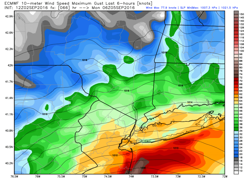
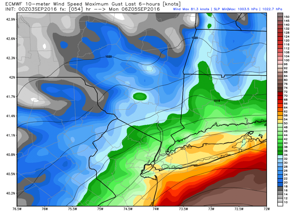
6z

00z
algae888- Advanced Forecaster
- Posts : 5311
Reputation : 46
Join date : 2013-02-05
Age : 61
Location : mt. vernon, new york
Re: Hurricane Hermine Discussion Part 2
![]() by algae888 Sat Sep 03, 2016 4:34 am
by algae888 Sat Sep 03, 2016 4:34 am

6z

00z
algae888- Advanced Forecaster
- Posts : 5311
Reputation : 46
Join date : 2013-02-05
Age : 61
Location : mt. vernon, new york
Re: Hurricane Hermine Discussion Part 2
![]() by algae888 Sat Sep 03, 2016 4:41 am
by algae888 Sat Sep 03, 2016 4:41 am
The following impacts are at least possible if not expected:
1) Dangerous Rip Currents are expected from this weekend through
the middle of next week.
2) Moderate to probably major coastal flooding is likely from
Sunday into at least Monday and possibly Tuesday. Significant
beach erosion from high surf is also likely. Refer to the tides
and coastal flooding section of the AFD for details.
3) Sustained Winds to Tropical Storm Force (at least 39 mph) are
possible over mainly southern coastal areas from late Sunday into
Monday morning.
4) Locally heavy rainfall producing localized fresh water flooding
remains a relatively low threat. Refer to the hydrology section of
the AFD for details.
The ECMWF is alone in bringing in measurable precipitation before
12z Sunday...so have basically followed a non-ECMWF blend for
timing/distribution of precipitation. As a result have only chance
pops Sunday, then likely pops from Sunday night into Monday night.
Still have uncertainty on how fast Hermine exits to the east (The
ECMWF for now is a progressive outlier), so linger chance pops
into Wednesday - mainly over eastern zones.
beach erosion and coastal flooding main concern. tropical force sustained winds now confined to southern most areas.
algae888- Advanced Forecaster
- Posts : 5311
Reputation : 46
Join date : 2013-02-05
Age : 61
Location : mt. vernon, new york
Re: Hurricane Hermine Discussion Part 2
![]() by algae888 Sat Sep 03, 2016 4:45 am
by algae888 Sat Sep 03, 2016 4:45 am

4k nam also and 10 mb weaker.

algae888- Advanced Forecaster
- Posts : 5311
Reputation : 46
Join date : 2013-02-05
Age : 61
Location : mt. vernon, new york
Re: Hurricane Hermine Discussion Part 2
![]() by skinsfan1177 Sat Sep 03, 2016 5:06 am
by skinsfan1177 Sat Sep 03, 2016 5:06 am

skinsfan1177- Senior Enthusiast
- Posts : 4485
Reputation : 35
Join date : 2013-01-07
Age : 46
Location : Point Pleasant Boro
Re: Hurricane Hermine Discussion Part 2
![]() by NjWeatherGuy Sat Sep 03, 2016 5:24 am
by NjWeatherGuy Sat Sep 03, 2016 5:24 am
NjWeatherGuy- Advanced Forecaster
- Posts : 4100
Reputation : 28
Join date : 2013-01-06
Location : Belle Mead, NJ
Re: Hurricane Hermine Discussion Part 2
![]() by SoulSingMG Sat Sep 03, 2016 5:41 am
by SoulSingMG Sat Sep 03, 2016 5:41 am
NjWeatherGuy wrote:Observations seem to show precip shield hitting a wall as storm movement becomes more ENE, looks like its probably centered over water already, again, southern edge of cone = well south of hatteras verifying = further east solution.
Yup. Big turn of events overnight. Dodged a big bullet it seems.
SoulSingMG- Senior Enthusiast
- Posts : 2853
Reputation : 74
Join date : 2013-12-11
Location : Long Island City, NY
Re: Hurricane Hermine Discussion Part 2
![]() by skinsfan1177 Sat Sep 03, 2016 5:46 am
by skinsfan1177 Sat Sep 03, 2016 5:46 am
skinsfan1177- Senior Enthusiast
- Posts : 4485
Reputation : 35
Join date : 2013-01-07
Age : 46
Location : Point Pleasant Boro
Re: Hurricane Hermine Discussion Part 2
![]() by jmanley32 Sat Sep 03, 2016 5:53 am
by jmanley32 Sat Sep 03, 2016 5:53 am

jmanley32- Senior Enthusiast
- Posts : 20516
Reputation : 108
Join date : 2013-12-12
Age : 42
Location : Yonkers, NY
Re: Hurricane Hermine Discussion Part 2
![]() by jmanley32 Sat Sep 03, 2016 5:54 am
by jmanley32 Sat Sep 03, 2016 5:54 am
ugg skins this is aging me and I'm only 35 lolskinsfan1177 wrote:Will see I wouldn't rule anything out yet a shift here or their could mean big problems or not
jmanley32- Senior Enthusiast
- Posts : 20516
Reputation : 108
Join date : 2013-12-12
Age : 42
Location : Yonkers, NY
Re: Hurricane Hermine Discussion Part 2
![]() by jmanley32 Sat Sep 03, 2016 5:57 am
by jmanley32 Sat Sep 03, 2016 5:57 am
jmanley32- Senior Enthusiast
- Posts : 20516
Reputation : 108
Join date : 2013-12-12
Age : 42
Location : Yonkers, NY
Re: Hurricane Hermine Discussion Part 2
![]() by skinsfan1177 Sat Sep 03, 2016 6:11 am
by skinsfan1177 Sat Sep 03, 2016 6:11 am
skinsfan1177- Senior Enthusiast
- Posts : 4485
Reputation : 35
Join date : 2013-01-07
Age : 46
Location : Point Pleasant Boro
Re: Hurricane Hermine Discussion Part 2
![]() by jmanley32 Sat Sep 03, 2016 6:14 am
by jmanley32 Sat Sep 03, 2016 6:14 am
jmanley32- Senior Enthusiast
- Posts : 20516
Reputation : 108
Join date : 2013-12-12
Age : 42
Location : Yonkers, NY
Re: Hurricane Hermine Discussion Part 2
![]() by skinsfan1177 Sat Sep 03, 2016 6:15 am
by skinsfan1177 Sat Sep 03, 2016 6:15 am
skinsfan1177- Senior Enthusiast
- Posts : 4485
Reputation : 35
Join date : 2013-01-07
Age : 46
Location : Point Pleasant Boro
Re: Hurricane Hermine Discussion Part 2
![]() by jmanley32 Sat Sep 03, 2016 6:32 am
by jmanley32 Sat Sep 03, 2016 6:32 am
jmanley32- Senior Enthusiast
- Posts : 20516
Reputation : 108
Join date : 2013-12-12
Age : 42
Location : Yonkers, NY
Re: Hurricane Hermine Discussion Part 2
![]() by docstox12 Sat Sep 03, 2016 6:34 am
by docstox12 Sat Sep 03, 2016 6:34 am
skinsfan1177 wrote:Honestly I'm ok with it after I went through with Sandy that's was enough for me
EXACTLY skins.So glad to read this thing is becoming less and less of a threat.The NJ Shore has just recovered from that disaster.Let's get a Hermine that hits us in JANUARY so we can enjoy an area wide 25 to 30 inch snowstorm, with less winds and MORE snow!!!

docstox12- Wx Statistician Guru

- Posts : 8504
Reputation : 222
Join date : 2013-01-07
Age : 73
Location : Monroe NY
Re: Hurricane Hermine Discussion Part 2
![]() by sroc4 Sat Sep 03, 2016 6:39 am
by sroc4 Sat Sep 03, 2016 6:39 am
NjWeatherGuy wrote: Hell, we might not even see a drop of rainfall, just a few cloudy and windy days, call it downplaying, but the track is just leading me to believe theres not much to happen in our area, if we were a few hundred miles east we'd see quite a show as it looks to go back to full tropical but thats probably whats keeping it offshore. Had it merged fully with the trough and ridden up the coast it would likely have turned extratropical and had more impacts on us as many of past the storms had.
The hybrid/extratropical transition we are no longer seeing modeled to happen by us us probably why its staying out to see. Less trough interaction and capture.
After looking over the models this morning there is no doubt the axis of heaviest impacts are seemingly trending away from the coast, but I was trying to see what was different in the modeling. Tom I think you really hit the nail on the head with your comments highlighted above. We will have to look very closely at observations today and hone in on the hi res models.
_________________
"In weather and in life, there's no winning and losing; there's only winning and learning."
WINTER 2012/2013 TOTALS 43.65"WINTER 2017/2018 TOTALS 62.85" WINTER 2022/2023 TOTALS 4.9"
WINTER 2013/2014 TOTALS 64.85"WINTER 2018/2019 TOTALS 14.25" WINTER 2023/2024 TOTALS 13.1"
WINTER 2014/2015 TOTALS 71.20"WINTER 2019/2020 TOTALS 6.35"
WINTER 2015/2016 TOTALS 35.00"WINTER 2020/2021 TOTALS 37.75"
WINTER 2016/2017 TOTALS 42.25"WINTER 2021/2022 TOTALS 31.65"

sroc4- Admin

- Posts : 8331
Reputation : 301
Join date : 2013-01-07
Location : Wading River, LI
Re: Hurricane Hermine Discussion Part 2
![]() by sroc4 Sat Sep 03, 2016 6:47 am
by sroc4 Sat Sep 03, 2016 6:47 am
NjWeatherGuy wrote:Observations seem to show precip shield hitting a wall as storm movement becomes more ENE, looks like its probably centered over water already, again, southern edge of cone = well south of hatteras verifying = further east solution.
_________________
"In weather and in life, there's no winning and losing; there's only winning and learning."
WINTER 2012/2013 TOTALS 43.65"WINTER 2017/2018 TOTALS 62.85" WINTER 2022/2023 TOTALS 4.9"
WINTER 2013/2014 TOTALS 64.85"WINTER 2018/2019 TOTALS 14.25" WINTER 2023/2024 TOTALS 13.1"
WINTER 2014/2015 TOTALS 71.20"WINTER 2019/2020 TOTALS 6.35"
WINTER 2015/2016 TOTALS 35.00"WINTER 2020/2021 TOTALS 37.75"
WINTER 2016/2017 TOTALS 42.25"WINTER 2021/2022 TOTALS 31.65"
sroc4- Admin
- Posts : 8331
Reputation : 301
Join date : 2013-01-07
Location : Wading River, LI
Re: Hurricane Hermine Discussion Part 2
![]() by sroc4 Sat Sep 03, 2016 6:50 am
by sroc4 Sat Sep 03, 2016 6:50 am

_________________
"In weather and in life, there's no winning and losing; there's only winning and learning."
WINTER 2012/2013 TOTALS 43.65"WINTER 2017/2018 TOTALS 62.85" WINTER 2022/2023 TOTALS 4.9"
WINTER 2013/2014 TOTALS 64.85"WINTER 2018/2019 TOTALS 14.25" WINTER 2023/2024 TOTALS 13.1"
WINTER 2014/2015 TOTALS 71.20"WINTER 2019/2020 TOTALS 6.35"
WINTER 2015/2016 TOTALS 35.00"WINTER 2020/2021 TOTALS 37.75"
WINTER 2016/2017 TOTALS 42.25"WINTER 2021/2022 TOTALS 31.65"
sroc4- Admin
- Posts : 8331
Reputation : 301
Join date : 2013-01-07
Location : Wading River, LI
Re: Hurricane Hermine Discussion Part 2
![]() by rb924119 Sat Sep 03, 2016 7:22 am
by rb924119 Sat Sep 03, 2016 7:22 am
rb924119- Meteorologist

- Posts : 6890
Reputation : 194
Join date : 2013-02-06
Age : 32
Location : Greentown, Pa
Page 8 of 35 • 1 ... 5 ... 7, 8, 9 ... 21 ... 35 ![]()
|
|
|