
 Search
Hurricane Hermine Discussion Part 2
Page 15 of 35 •  1 ... 9 ... 14, 15, 16 ... 25 ... 35
 ![]()
Re: Hurricane Hermine Discussion Part 2
![]() by WeatherBob Sat Sep 03, 2016 12:07 pm
by WeatherBob Sat Sep 03, 2016 12:07 pm

WeatherBob- Meteorologist

- Posts : 683
Join date : 2013-12-13
Re: Hurricane Hermine Discussion Part 2
![]() by jmanley32 Sat Sep 03, 2016 12:10 pm
by jmanley32 Sat Sep 03, 2016 12:10 pm
jmanley32- Senior Enthusiast

- Posts : 20517
Join date : 2013-12-12
Re: Hurricane Hermine Discussion Part 2
![]() by NjWeatherGuy Sat Sep 03, 2016 12:10 pm
by NjWeatherGuy Sat Sep 03, 2016 12:10 pm
Math23x7 wrote:Tom, what are your thoughts on the 12Z RGEM?
Just looked at it, its certainly aggressive, so this is tomorrow night according to it.
http://www.tropicaltidbits.com/analysis/models/?model=rgem®ion=us&pkg=mslp_pcpn_frzn&runtime=2016090312&fh=36&xpos=0&ypos=53
Than this is Monday morning??
http://www.tropicaltidbits.com/analysis/models/?model=rgem®ion=us&pkg=mslp_pcpn_frzn&runtime=2016090312&fh=48&xpos=0&ypos=429
Not like we havent seen that, but its very rare and I'm just doubtful still.

NjWeatherGuy- Advanced Forecaster

- Posts : 4100
Reputation : 28
Join date : 2013-01-06
Location : Belle Mead, NJ
Re: Hurricane Hermine Discussion Part 2
![]() by jmanley32 Sat Sep 03, 2016 12:13 pm
by jmanley32 Sat Sep 03, 2016 12:13 pm
are those winds ur forcast for all areas including the warning areas up here in nyc and southern wc ct shore etc? So now it's pushed to monday? What do u think about the highest hurricane level it will reach wind wise. I understand won't b close enough just curious as its got a lot warm water to feed off of.Frank_Wx wrote:Here's the moral of the story:
1. Very little rain impact for most, including the coast. Shores could see 1-2 inches of rain which is not a big deal. Everyone inland will see little to no rain. Dry air will wrap into the storm and prevent any convective banding from moving onshore, though coastal areas could still see heavy banding.
2. Winds along the coast will be sustained 35-45mph with gusts reaching 70mph at times. I wouldn't be shocked if someone recorded hurricane force winds at 75mph. Winds away from the coast will be sustained 25-35mph with gusts exceeding 50mph at times. There could be a period of time where winds are consistently above 40mph and that could lead to isolated power outages.
3. Coastal flooding is the main takeaway. Some towns in SNJ are already seeing it. Surge of 4-6 feet is expected up and down NJ into LI too. In conjunction with the tropical storm force winds that is not a pleasant situation. If you live on the shore I would prepare for flooding and power outages now just in case.
Overall, Hermine does not look like it will take a westerly turn once it gets 50-75 miles east of NJ. It may spin and stall, but that's different then physically tracking due west which would have been disastrous for the area. We're catching a huge break.
If anything changes with modeling today that would make me think the above forecast needs to be updated I will let you know. For now, that's my forecast.
Edit:
Timing is Sunday afternoon through Wednesday afternoon. Yes, that's almost 4 days of high winds and dangerous surge. Consider this, that's like 8 high tide cycles Hermine has to work with. We'll begin to clear by Thursday when another heat wave is set to warm the area. Just remember...4 days! Worst of it will be Monday and Tuesday.

jmanley32- Senior Enthusiast
- Posts : 20517
Reputation : 108
Join date : 2013-12-12
Age : 42
Location : Yonkers, NY
Re: Hurricane Hermine Discussion Part 2
![]() by Frank_Wx Sat Sep 03, 2016 12:14 pm
by Frank_Wx Sat Sep 03, 2016 12:14 pm

_________________
_______________________________________________________________________________________________________
CLICK HERE to view NJ Strong Snowstorm Classifications

Frank_Wx- Godzilla Seeker

- Posts : 21305
Reputation : 328
Join date : 2013-01-05
Age : 31
Location : Jersey City, NJ -

Re: Hurricane Hermine Discussion Part 2
![]() by NjWeatherGuy Sat Sep 03, 2016 12:17 pm
by NjWeatherGuy Sat Sep 03, 2016 12:17 pm
http://meteocentre.com/models/explorateur.php?lang=en&map=na&run=12&mod=gemreg&stn=PNMPR&comp=1&run2=12&mod2=gemreg&stn2=PNMPR&hh2=054&fixhh=1&stn2_type=prog&mode=latest&yyyy=latest&mm=latest&dd=latest&hh=048
NjWeatherGuy- Advanced Forecaster
- Posts : 4100
Reputation : 28
Join date : 2013-01-06
Location : Belle Mead, NJ
rb924119- Meteorologist
- Posts : 6890
Reputation : 194
Join date : 2013-02-06
Age : 32
Location : Greentown, Pa
Re: Hurricane Hermine Discussion Part 2
![]() by WeatherBob Sat Sep 03, 2016 12:21 pm
by WeatherBob Sat Sep 03, 2016 12:21 pm

WeatherBob- Meteorologist
- Posts : 683
Reputation : 83
Join date : 2013-12-13
Location : Caldwell, NJ - NW Essex County - Altitude 500 FT
Re: Hurricane Hermine Discussion Part 2
![]() by Snow88 Sat Sep 03, 2016 12:22 pm
by Snow88 Sat Sep 03, 2016 12:22 pm

Snow88- Senior Enthusiast
- Posts : 2193
Reputation : 4
Join date : 2013-01-09
Age : 35
Location : Brooklyn, NY
Re: Hurricane Hermine Discussion Part 2
![]() by jmanley32 Sat Sep 03, 2016 12:28 pm
by jmanley32 Sat Sep 03, 2016 12:28 pm
jmanley32- Senior Enthusiast
- Posts : 20517
Reputation : 108
Join date : 2013-12-12
Age : 42
Location : Yonkers, NY
Re: Hurricane Hermine Discussion Part 2
![]() by Snow88 Sat Sep 03, 2016 12:33 pm
by Snow88 Sat Sep 03, 2016 12:33 pm
http://www.tropicaltidbits.com/analysis/models/gem/2016090312/gem_apcpn_us_20.png
Snow88- Senior Enthusiast
- Posts : 2193
Reputation : 4
Join date : 2013-01-09
Age : 35
Location : Brooklyn, NY
Re: Hurricane Hermine Discussion Part 2
![]() by NjWeatherGuy Sat Sep 03, 2016 12:34 pm
by NjWeatherGuy Sat Sep 03, 2016 12:34 pm
http://www.tropicaltidbits.com/analysis/models/?model=gfdl®ion=09L&pkg=mslp_uv850&runtime=2016090306&fh=42&xpos=0&ypos=249
NjWeatherGuy- Advanced Forecaster
- Posts : 4100
Reputation : 28
Join date : 2013-01-06
Location : Belle Mead, NJ
Re: Hurricane Hermine Discussion Part 2
![]() by jmanley32 Sat Sep 03, 2016 12:36 pm
by jmanley32 Sat Sep 03, 2016 12:36 pm
jmanley32- Senior Enthusiast
- Posts : 20517
Reputation : 108
Join date : 2013-12-12
Age : 42
Location : Yonkers, NY
Re: Hurricane Hermine Discussion Part 2
![]() by Snow88 Sat Sep 03, 2016 12:46 pm
by Snow88 Sat Sep 03, 2016 12:46 pm
http://meteocentre.com/models/explorateur.php?lang=en&map=na&run=12&mod=ukmet&stn=PNM&comp=1&run2=12&mod2=ukmet&stn2=PNM&hh2=072&fixhh=1&stn2_type=prog&mode=latest&yyyy=latest&mm=latest&dd=latest&hh=060
Snow88- Senior Enthusiast
- Posts : 2193
Reputation : 4
Join date : 2013-01-09
Age : 35
Location : Brooklyn, NY
Re: Hurricane Hermine Discussion Part 2
![]() by Math23x7 Sat Sep 03, 2016 12:54 pm
by Math23x7 Sat Sep 03, 2016 12:54 pm
Math23x7- Wx Statistician Guru

- Posts : 2379
Reputation : 68
Join date : 2013-01-08
Re: Hurricane Hermine Discussion Part 2
![]() by jmanley32 Sat Sep 03, 2016 1:04 pm
by jmanley32 Sat Sep 03, 2016 1:04 pm
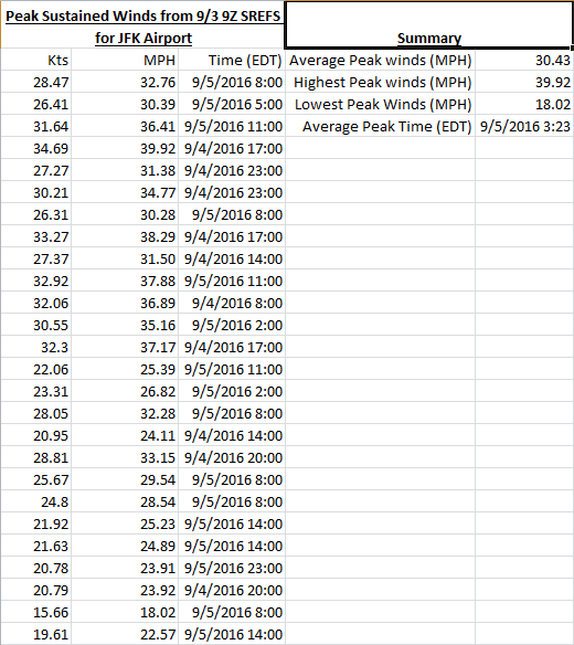
Math23x7 wrote:I pieced together some information regarding the 9Z SREFs. I used JFK airport because I'm just a few miles NNE of there. Using the 26 members, I put in the highest sustained wind speed (which I converted from kts to mph) and put in the time of the peak sustained winds. I then summarized the information: Franks forecast almost exactly. Prolly bout same here in southern wc. Maybe bit less. We will see. We really don't totally know how far north or west hermine will go and it appears intensity all over on models. They seem useless honestly.
jmanley32- Senior Enthusiast
- Posts : 20517
Reputation : 108
Join date : 2013-12-12
Age : 42
Location : Yonkers, NY
Re: Hurricane Hermine Discussion Part 2
![]() by amugs Sat Sep 03, 2016 1:04 pm
by amugs Sat Sep 03, 2016 1:04 pm

Slowing down - HP is going to flex its muscle -Ukie showing a North jog but a more west trend
Gfs is chasing the convection on teh east side of this - displaces the L center of circulation to far east imo as per satellite.
Jersey shore is going to be saying 1962 storm?
_________________
Mugs
AKA:King: Snow Weenie
Self Proclaimed
WINTER 2014-15 : 55.12" +.02 for 6 coatings (avg. 35")
WINTER 2015-16 Total - 29.8" (Avg 35")
WINTER 2016-17 : 39.5" so far

amugs- Advanced Forecaster - Mod

- Posts : 15093
Reputation : 213
Join date : 2013-01-07
Age : 54
Location : Hillsdale,NJ
Re: Hurricane Hermine Discussion Part 2
![]() by jmanley32 Sat Sep 03, 2016 1:05 pm
by jmanley32 Sat Sep 03, 2016 1:05 pm
jmanley32- Senior Enthusiast
- Posts : 20517
Reputation : 108
Join date : 2013-12-12
Age : 42
Location : Yonkers, NY
Re: Hurricane Hermine Discussion Part 2
![]() by aiannone Sat Sep 03, 2016 1:06 pm
by aiannone Sat Sep 03, 2016 1:06 pm
_________________
-Alex Iannone-

aiannone- Senior Enthusiast - Mod
- Posts : 4814
Reputation : 92
Join date : 2013-01-07
Location : Saint James, LI (Northwest Suffolk Co.)
Re: Hurricane Hermine Discussion Part 2
![]() by jmanley32 Sat Sep 03, 2016 1:07 pm
by jmanley32 Sat Sep 03, 2016 1:07 pm
jmanley32- Senior Enthusiast
- Posts : 20517
Reputation : 108
Join date : 2013-12-12
Age : 42
Location : Yonkers, NY
Re: Hurricane Hermine Discussion Part 2
![]() by jmanley32 Sat Sep 03, 2016 1:09 pm
by jmanley32 Sat Sep 03, 2016 1:09 pm
when is it supposed to reintensify no real convection firing center pretty devoid.amugs wrote:
Slowing down - HP is going to flex its muscle -Ukie showing a North jog but a more west trend
Gfs is chasing the convection on teh east side of this - displaces the L center of circulation to far east imo as per satellite.
Jersey shore is going to be saying 1962 storm?
jmanley32- Senior Enthusiast
- Posts : 20517
Reputation : 108
Join date : 2013-12-12
Age : 42
Location : Yonkers, NY
Re: Hurricane Hermine Discussion Part 2
![]() by NjWeatherGuy Sat Sep 03, 2016 1:10 pm
by NjWeatherGuy Sat Sep 03, 2016 1:10 pm
http://www.tropicaltidbits.com/analysis/models/?model=hwrf®ion=09L&pkg=mslp_wind&runtime=2016090312&fh=51&xpos=0&ypos=199
NjWeatherGuy- Advanced Forecaster
- Posts : 4100
Reputation : 28
Join date : 2013-01-06
Location : Belle Mead, NJ
Re: Hurricane Hermine Discussion Part 2
![]() by rb924119 Sat Sep 03, 2016 1:14 pm
by rb924119 Sat Sep 03, 2016 1:14 pm
NjWeatherGuy wrote:12z HWRF seems quite a bit further west
http://www.tropicaltidbits.com/analysis/models/?model=hwrf®ion=09L&pkg=mslp_wind&runtime=2016090312&fh=51&xpos=0&ypos=199
It's comparable to 00z. Are you comparing to 06z?
rb924119- Meteorologist
- Posts : 6890
Reputation : 194
Join date : 2013-02-06
Age : 32
Location : Greentown, Pa
Re: Hurricane Hermine Discussion Part 2
![]() by jmanley32 Sat Sep 03, 2016 1:14 pm
by jmanley32 Sat Sep 03, 2016 1:14 pm
jmanley32- Senior Enthusiast
- Posts : 20517
Reputation : 108
Join date : 2013-12-12
Age : 42
Location : Yonkers, NY
Re: Hurricane Hermine Discussion Part 2
![]() by jmanley32 Sat Sep 03, 2016 1:17 pm
by jmanley32 Sat Sep 03, 2016 1:17 pm
jmanley32- Senior Enthusiast
- Posts : 20517
Reputation : 108
Join date : 2013-12-12
Age : 42
Location : Yonkers, NY
Re: Hurricane Hermine Discussion Part 2
![]() by NjWeatherGuy Sat Sep 03, 2016 1:18 pm
by NjWeatherGuy Sat Sep 03, 2016 1:18 pm
NjWeatherGuy wrote:Not sure what I stumbled upon, but I highly doubt its accurate...
http://meteocentre.com/models/explorateur.php?lang=en&map=na&run=12&mod=gemreg&stn=PNMPR&comp=1&run2=12&mod2=gemreg&stn2=PNMPR&hh2=054&fixhh=1&stn2_type=prog&mode=latest&yyyy=latest&mm=latest&dd=latest&hh=048
Yep its the CMC, these models really do drive you nuts. I've been up all night since work and have to work again tonight and we'll see where things are. Since things keep evolving (initally it was shown to ride the coast and possibly make second landfall and come right at us, then we see an OTS solution, now a possible close pass retrograde after heading NE off the Carolinas), I still think a further east solution is possible, (misses capture), I think a stall somewhere where the GFS shows is possible, and now maybe a close call to or maybe even a second landfall again could be trending, still another day or two of runs before its nailed down completely. Tropical systems are very unpredictable, may check in a few more times as I eat my much before I go to bed but this has been a hell of a ride...
NjWeatherGuy- Advanced Forecaster
- Posts : 4100
Reputation : 28
Join date : 2013-01-06
Location : Belle Mead, NJ
Re: Hurricane Hermine Discussion Part 2
![]() by NjWeatherGuy Sat Sep 03, 2016 1:21 pm
by NjWeatherGuy Sat Sep 03, 2016 1:21 pm
rb924119 wrote:NjWeatherGuy wrote:12z HWRF seems quite a bit further west
http://www.tropicaltidbits.com/analysis/models/?model=hwrf®ion=09L&pkg=mslp_wind&runtime=2016090312&fh=51&xpos=0&ypos=199
It's comparable to 00z. Are you comparing to 06z?
Yes to the 6z its significantly further west, to the 0z its a hair north and a mb stronger.
NjWeatherGuy- Advanced Forecaster
- Posts : 4100
Reputation : 28
Join date : 2013-01-06
Location : Belle Mead, NJ
Page 15 of 35 • 1 ... 9 ... 14, 15, 16 ... 25 ... 35 ![]()
|
|
|