
 Search
June 12th-13th Severe Weather Discussions/Observations Thread
Page 2 of 3 •  1, 2, 3
 ![]()
Re: June 12th-13th Severe Weather Discussions/Observations Thread
![]() by Math23x7 Wed Jun 12, 2013 12:29 pm
by Math23x7 Wed Jun 12, 2013 12:29 pm
Math23x7- Wx Statistician Guru

- Posts : 2379
Join date : 2013-01-08
Re: June 12th-13th Severe Weather Discussions/Observations Thread
![]() by Frank_Wx Wed Jun 12, 2013 1:06 pm
by Frank_Wx Wed Jun 12, 2013 1:06 pm
Frank_Wx- Godzilla Seeker

- Posts : 21305
Join date : 2013-01-05 -

Re: June 12th-13th Severe Weather Discussions/Observations Thread
![]() by Frank_Wx Wed Jun 12, 2013 1:58 pm
by Frank_Wx Wed Jun 12, 2013 1:58 pm

Map for tomorrow

Frank_Wx- Godzilla Seeker
- Posts : 21305
Reputation : 328
Join date : 2013-01-05
Age : 31
Location : Jersey City, NJ -
Re: June 12th-13th Severe Weather Discussions/Observations Thread
![]() by Quietace Wed Jun 12, 2013 2:21 pm
by Quietace Wed Jun 12, 2013 2:21 pm

Quietace- Meteorologist - Mod

- Posts : 3687
Reputation : 33
Join date : 2013-01-07
Age : 27
Location : Point Pleasant, NJ
Re: June 12th-13th Severe Weather Discussions/Observations Thread
![]() by Frank_Wx Wed Jun 12, 2013 3:16 pm
by Frank_Wx Wed Jun 12, 2013 3:16 pm
Frank_Wx- Godzilla Seeker
- Posts : 21305
Reputation : 328
Join date : 2013-01-05
Age : 31
Location : Jersey City, NJ -
Re: June 12th-13th Severe Weather Discussions/Observations Thread
![]() by Frank_Wx Wed Jun 12, 2013 3:18 pm
by Frank_Wx Wed Jun 12, 2013 3:18 pm

NAM radar is impressive for tomorrow.
Frank_Wx- Godzilla Seeker
- Posts : 21305
Reputation : 328
Join date : 2013-01-05
Age : 31
Location : Jersey City, NJ -
Re: June 12th-13th Severe Weather Discussions/Observations Thread
![]() by Quietace Wed Jun 12, 2013 3:33 pm
by Quietace Wed Jun 12, 2013 3:33 pm

Quietace- Meteorologist - Mod
- Posts : 3687
Reputation : 33
Join date : 2013-01-07
Age : 27
Location : Point Pleasant, NJ
Re: June 12th-13th Severe Weather Discussions/Observations Thread
![]() by Quietace Wed Jun 12, 2013 3:45 pm
by Quietace Wed Jun 12, 2013 3:45 pm
Frank_Wx wrote:The models are kind of sheering the storm apart now. We have to see what radar looks like tomorrow morning and nowcast the storm
The GFS and NAM aren't really phasing with the energy coming out of Canada, its causing a much weaker system. With no phase, the precipitation is weaker and dies out until the coastal low gets going.
For example the 12z NAM, the original piece of energy moving east is almost off shore. The second energy hasnt even interacted with it, and almost never does, this causes no energy to pump into the system, so it never really strengthens that severely.

Yesterday, we were worried why the NAM was too north, it had too much interaction with the energy, phased it early and pulled it north with exaggerated QPF totals. I feel, since the complexity of the upper level systems, all three of them ( ULL near Maine, Energy in Canada, and the low out west), just as in winter, the models may be mishandling them. As frank said, looking at the current obs, tonight and tomorrow will give us more info on how the low is deepening, and how the systems are interacting.
I think the models will trend back to a stronger system, this is a classic model shift back and forth.
Quietace- Meteorologist - Mod
- Posts : 3687
Reputation : 33
Join date : 2013-01-07
Age : 27
Location : Point Pleasant, NJ
Re: June 12th-13th Severe Weather Discussions/Observations Thread
![]() by Frank_Wx Wed Jun 12, 2013 4:12 pm
by Frank_Wx Wed Jun 12, 2013 4:12 pm
Frank_Wx- Godzilla Seeker
- Posts : 21305
Reputation : 328
Join date : 2013-01-05
Age : 31
Location : Jersey City, NJ -
Re: June 12th-13th Severe Weather Discussions/Observations Thread
![]() by Frank_Wx Wed Jun 12, 2013 4:13 pm
by Frank_Wx Wed Jun 12, 2013 4:13 pm

Frank_Wx- Godzilla Seeker
- Posts : 21305
Reputation : 328
Join date : 2013-01-05
Age : 31
Location : Jersey City, NJ -
Re: June 12th-13th Severe Weather Discussions/Observations Thread
![]() by Math23x7 Wed Jun 12, 2013 4:56 pm
by Math23x7 Wed Jun 12, 2013 4:56 pm
Math23x7- Wx Statistician Guru
- Posts : 2379
Reputation : 68
Join date : 2013-01-08
Re: June 12th-13th Severe Weather Discussions/Observations Thread
![]() by Quietace Wed Jun 12, 2013 4:59 pm
by Quietace Wed Jun 12, 2013 4:59 pm
Im a little worried for coastal areas, that run was screaming east winds slamming into the coast for a while
Quietace- Meteorologist - Mod
- Posts : 3687
Reputation : 33
Join date : 2013-01-07
Age : 27
Location : Point Pleasant, NJ
Re: June 12th-13th Severe Weather Discussions/Observations Thread
![]() by Frank_Wx Wed Jun 12, 2013 6:48 pm
by Frank_Wx Wed Jun 12, 2013 6:48 pm
Frank_Wx- Godzilla Seeker
- Posts : 21305
Reputation : 328
Join date : 2013-01-05
Age : 31
Location : Jersey City, NJ -
Re: June 12th-13th Severe Weather Discussions/Observations Thread
![]() by Frank_Wx Wed Jun 12, 2013 7:07 pm
by Frank_Wx Wed Jun 12, 2013 7:07 pm

Frank_Wx- Godzilla Seeker
- Posts : 21305
Reputation : 328
Join date : 2013-01-05
Age : 31
Location : Jersey City, NJ -
Re: June 12th-13th Severe Weather Discussions/Observations Thread
![]() by Quietace Wed Jun 12, 2013 8:00 pm
by Quietace Wed Jun 12, 2013 8:00 pm
And i just looked at the GFS 500mb, the way it handles everything is just flat out bizarre, it phases with the energy put of Canada early, pulling it and the convection to the north, and then phases with a piece of energy that broke off the ULL and pulls it and the convection further north. That third piece of energy breaking off the ULL dose not exist that far south, on other models, it only interacts with it when its past the Canadian Maritime.
Here is the early interaction

They phase then start to interact with a piece of energy attached to the ULL

Then you can see both piece of energy converge, pulling the LP north
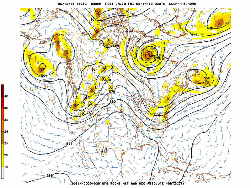

Unless every other model is not picking up on that last piece of energy breaking off the ULL that south, then the GFS is wrong. Jeez, i though the Model Madness was over this morning......i was wrong lol
Quietace- Meteorologist - Mod
- Posts : 3687
Reputation : 33
Join date : 2013-01-07
Age : 27
Location : Point Pleasant, NJ
Re: June 12th-13th Severe Weather Discussions/Observations Thread
![]() by Quietace Wed Jun 12, 2013 8:12 pm
by Quietace Wed Jun 12, 2013 8:12 pm

There is you MCS
Quietace- Meteorologist - Mod
- Posts : 3687
Reputation : 33
Join date : 2013-01-07
Age : 27
Location : Point Pleasant, NJ
Re: June 12th-13th Severe Weather Discussions/Observations Thread
![]() by Frank_Wx Wed Jun 12, 2013 8:22 pm
by Frank_Wx Wed Jun 12, 2013 8:22 pm
Frank_Wx- Godzilla Seeker
- Posts : 21305
Reputation : 328
Join date : 2013-01-05
Age : 31
Location : Jersey City, NJ -
Re: June 12th-13th Severe Weather Discussions/Observations Thread
![]() by amugs Wed Jun 12, 2013 8:41 pm
by amugs Wed Jun 12, 2013 8:41 pm
_________________
Mugs
AKA:King: Snow Weenie
Self Proclaimed
WINTER 2014-15 : 55.12" +.02 for 6 coatings (avg. 35")
WINTER 2015-16 Total - 29.8" (Avg 35")
WINTER 2016-17 : 39.5" so far

amugs- Advanced Forecaster - Mod

- Posts : 15093
Reputation : 213
Join date : 2013-01-07
Age : 54
Location : Hillsdale,NJ
Re: June 12th-13th Severe Weather Discussions/Observations Thread
![]() by Dunnzoo Wed Jun 12, 2013 8:46 pm
by Dunnzoo Wed Jun 12, 2013 8:46 pm
_________________
Janet
Snowfall winter of 2023-2024 17.5"
Snowfall winter of 2022-2023 6.0"
Snowfall winter of 2021-2022 17.6" 1" sleet 2/25/22
Snowfall winter of 2020-2021 51.1"
Snowfall winter of 2019-2020 8.5"
Snowfall winter of 2018-2019 25.1"
Snowfall winter of 2017-2018 51.9"
Snowfall winter of 2016-2017 45.6"
Snowfall winter of 2015-2016 29.5"
Snowfall winter of 2014-2015 50.55"
Snowfall winter of 2013-2014 66.5"

Dunnzoo- Senior Enthusiast - Mod
- Posts : 4891
Reputation : 68
Join date : 2013-01-11
Age : 62
Location : Westwood, NJ
Re: June 12th-13th Severe Weather Discussions/Observations Thread
![]() by Quietace Wed Jun 12, 2013 8:57 pm
by Quietace Wed Jun 12, 2013 8:57 pm
Quietace- Meteorologist - Mod
- Posts : 3687
Reputation : 33
Join date : 2013-01-07
Age : 27
Location : Point Pleasant, NJ
Re: June 12th-13th Severe Weather Discussions/Observations Thread
![]() by amugs Wed Jun 12, 2013 9:08 pm
by amugs Wed Jun 12, 2013 9:08 pm
_________________
Mugs
AKA:King: Snow Weenie
Self Proclaimed
WINTER 2014-15 : 55.12" +.02 for 6 coatings (avg. 35")
WINTER 2015-16 Total - 29.8" (Avg 35")
WINTER 2016-17 : 39.5" so far
amugs- Advanced Forecaster - Mod
- Posts : 15093
Reputation : 213
Join date : 2013-01-07
Age : 54
Location : Hillsdale,NJ
Re: June 12th-13th Severe Weather Discussions/Observations Thread
![]() by Quietace Wed Jun 12, 2013 10:57 pm
by Quietace Wed Jun 12, 2013 10:57 pm

Quietace- Meteorologist - Mod
- Posts : 3687
Reputation : 33
Join date : 2013-01-07
Age : 27
Location : Point Pleasant, NJ
Re: June 12th-13th Severe Weather Discussions/Observations Thread
![]() by Frank_Wx Wed Jun 12, 2013 11:50 pm
by Frank_Wx Wed Jun 12, 2013 11:50 pm
Frank_Wx- Godzilla Seeker
- Posts : 21305
Reputation : 328
Join date : 2013-01-05
Age : 31
Location : Jersey City, NJ -
Re: June 12th-13th Severe Weather Discussions/Observations Thread
![]() by Frank_Wx Thu Jun 13, 2013 12:22 am
by Frank_Wx Thu Jun 13, 2013 12:22 am

Frank_Wx- Godzilla Seeker
- Posts : 21305
Reputation : 328
Join date : 2013-01-05
Age : 31
Location : Jersey City, NJ -
Re: June 12th-13th Severe Weather Discussions/Observations Thread
![]() by Math23x7 Thu Jun 13, 2013 10:20 am
by Math23x7 Thu Jun 13, 2013 10:20 am
Math23x7- Wx Statistician Guru
- Posts : 2379
Reputation : 68
Join date : 2013-01-08
Re: June 12th-13th Severe Weather Discussions/Observations Thread
![]() by Frank_Wx Thu Jun 13, 2013 10:40 am
by Frank_Wx Thu Jun 13, 2013 10:40 am
Frank_Wx- Godzilla Seeker
- Posts : 21305
Reputation : 328
Join date : 2013-01-05
Age : 31
Location : Jersey City, NJ -
Re: June 12th-13th Severe Weather Discussions/Observations Thread
![]() by Frank_Wx Thu Jun 13, 2013 4:10 pm
by Frank_Wx Thu Jun 13, 2013 4:10 pm
Frank_Wx- Godzilla Seeker
- Posts : 21305
Reputation : 328
Join date : 2013-01-05
Age : 31
Location : Jersey City, NJ -
Sponsored content
Page 2 of 3 • 1, 2, 3 ![]()
|
|
|