
 Search
HURRICANE MATTHEW
Page 9 of 32 •  1 ... 6 ... 8, 9, 10 ... 20 ... 32
 ![]()

amugs- Advanced Forecaster - Mod

- Posts : 15093
Join date : 2013-01-07

jmanley32- Senior Enthusiast

- Posts : 20513
Join date : 2013-12-12

jmanley32- Senior Enthusiast
- Posts : 20513
Reputation : 108
Join date : 2013-12-12
Age : 42
Location : Yonkers, NY
Re: HURRICANE MATTHEW
![]() by Snow88 Wed Sep 28, 2016 12:38 pm
by Snow88 Wed Sep 28, 2016 12:38 pm
CMC shreds the storm and stays OTS lol

Snow88- Senior Enthusiast
- Posts : 2193
Reputation : 4
Join date : 2013-01-09
Age : 35
Location : Brooklyn, NY
Re: HURRICANE MATTHEW
![]() by jmanley32 Wed Sep 28, 2016 12:39 pm
by jmanley32 Wed Sep 28, 2016 12:39 pm
jmanley32- Senior Enthusiast
- Posts : 20513
Reputation : 108
Join date : 2013-12-12
Age : 42
Location : Yonkers, NY
Re: HURRICANE MATTHEW
![]() by jmanley32 Wed Sep 28, 2016 12:41 pm
by jmanley32 Wed Sep 28, 2016 12:41 pm
jmanley32- Senior Enthusiast
- Posts : 20513
Reputation : 108
Join date : 2013-12-12
Age : 42
Location : Yonkers, NY
jmanley32- Senior Enthusiast
- Posts : 20513
Reputation : 108
Join date : 2013-12-12
Age : 42
Location : Yonkers, NY
Re: HURRICANE MATTHEW
![]() by Snow88 Wed Sep 28, 2016 12:47 pm
by Snow88 Wed Sep 28, 2016 12:47 pm
jmanley32 wrote:Hmm both GFS and CMC now head east OTS, well maybe that door isn't closing, but where that block go?
CMC is OTS but not the GFS. The block is still there on the GFS. The trough is just a little too late on the GFS.
This is a week out so many more solutions to go
Snow88- Senior Enthusiast
- Posts : 2193
Reputation : 4
Join date : 2013-01-09
Age : 35
Location : Brooklyn, NY
Re: HURRICANE MATTHEW
![]() by sroc4 Wed Sep 28, 2016 12:48 pm
by sroc4 Wed Sep 28, 2016 12:48 pm
Quietace wrote:Whats the more reliable guidance? The NHC cone is basically a mean between the GFS/ECMWF if you take a look at the discussion. The usual prog for a uncertain scenario.algae888 wrote:Ace I don't believe the GFS positioning is correct it is way off of National Hurricane centers official forecast location. It's off at almost every position for the first 4 days. So then how can we trust the GFS days 5 or later plus most of the more reliable guidance has its south of where the GFS is showingQuietace wrote:Reasoning? I am not saying you are incorrect but why?algae888 wrote:Today's GFS is on the easternmost side of the cone from official National Hurricane Center forecast by 8 a.m. Sunday. It is Northwest of the official location by at least 150 miles if not more. I would take the GFS with a grain of salt it is not going to be right
I actually agree that the euro package has a better handle on the overall set up. Specifically the Atlantic ridge. It has been a force to be reckoned with all summer and has persistantly and adamantly reared its ugly head time and time again. In addition I think the track into the the E and Central Caribbean is too far north to begin with. I think the short term modeling of the shear and easterlies in the E and Central Caribbean will knock down the flare up we are seeing today albiet only temporarily. I still believe the combination of a WAR that ends up further west towards the coast will ultimately lend itself to a soln on the western half of the current forecast cone. The Euro IMO is handing these conditions correctly. Current observations of the shear and the low level easterlies out ahead of the system support this idea.
_________________
"In weather and in life, there's no winning and losing; there's only winning and learning."
WINTER 2012/2013 TOTALS 43.65"WINTER 2017/2018 TOTALS 62.85" WINTER 2022/2023 TOTALS 4.9"
WINTER 2013/2014 TOTALS 64.85"WINTER 2018/2019 TOTALS 14.25" WINTER 2023/2024 TOTALS 13.1"
WINTER 2014/2015 TOTALS 71.20"WINTER 2019/2020 TOTALS 6.35"
WINTER 2015/2016 TOTALS 35.00"WINTER 2020/2021 TOTALS 37.75"
WINTER 2016/2017 TOTALS 42.25"WINTER 2021/2022 TOTALS 31.65"

sroc4- Admin

- Posts : 8331
Reputation : 301
Join date : 2013-01-07
Location : Wading River, LI
Re: HURRICANE MATTHEW
![]() by sroc4 Wed Sep 28, 2016 12:51 pm
by sroc4 Wed Sep 28, 2016 12:51 pm
_________________
"In weather and in life, there's no winning and losing; there's only winning and learning."
WINTER 2012/2013 TOTALS 43.65"WINTER 2017/2018 TOTALS 62.85" WINTER 2022/2023 TOTALS 4.9"
WINTER 2013/2014 TOTALS 64.85"WINTER 2018/2019 TOTALS 14.25" WINTER 2023/2024 TOTALS 13.1"
WINTER 2014/2015 TOTALS 71.20"WINTER 2019/2020 TOTALS 6.35"
WINTER 2015/2016 TOTALS 35.00"WINTER 2020/2021 TOTALS 37.75"
WINTER 2016/2017 TOTALS 42.25"WINTER 2021/2022 TOTALS 31.65"
sroc4- Admin
- Posts : 8331
Reputation : 301
Join date : 2013-01-07
Location : Wading River, LI
Re: HURRICANE MATTHEW
![]() by Quietace Wed Sep 28, 2016 12:54 pm
by Quietace Wed Sep 28, 2016 12:54 pm
I will just stress that all guidance at this point should be handled equally. I wouldn't make definite statements, its a observation period, not forecast period.sroc4 wrote:Quietace wrote:Whats the more reliable guidance? The NHC cone is basically a mean between the GFS/ECMWF if you take a look at the discussion. The usual prog for a uncertain scenario.algae888 wrote:Ace I don't believe the GFS positioning is correct it is way off of National Hurricane centers official forecast location. It's off at almost every position for the first 4 days. So then how can we trust the GFS days 5 or later plus most of the more reliable guidance has its south of where the GFS is showingQuietace wrote:Reasoning? I am not saying you are incorrect but why?algae888 wrote:Today's GFS is on the easternmost side of the cone from official National Hurricane Center forecast by 8 a.m. Sunday. It is Northwest of the official location by at least 150 miles if not more. I would take the GFS with a grain of salt it is not going to be right
I actually agree that the euro package has a better handle on the overall set up. Specifically the Atlantic ridge. It has been a force to be reckoned with all summer and has persistantly and adamantly reared its ugly head time and time again. In addition I think the track into the the E and Central Caribbean is too far north to begin with. I think the short term modeling of the shear and easterlies in the E and Central Caribbean will knock down the flare up we are seeing today albiet only temporarily. I still believe the combination of a WAR that ends up further west towards the coast will ultimately lend itself to a soln on the western half of the current forecast cone. The Euro IMO is handing these conditions correctly. Current observations of the shear and the low level easterlies out ahead of the system support this idea.

Quietace- Meteorologist - Mod

- Posts : 3687
Reputation : 33
Join date : 2013-01-07
Age : 27
Location : Point Pleasant, NJ
Re: HURRICANE MATTHEW
![]() by algae888 Wed Sep 28, 2016 12:56 pm
by algae888 Wed Sep 28, 2016 12:56 pm

algae888- Advanced Forecaster

- Posts : 5311
Reputation : 46
Join date : 2013-02-05
Age : 61
Location : mt. vernon, new york
Re: HURRICANE MATTHEW
![]() by algae888 Wed Sep 28, 2016 1:02 pm
by algae888 Wed Sep 28, 2016 1:02 pm
algae888- Advanced Forecaster
- Posts : 5311
Reputation : 46
Join date : 2013-02-05
Age : 61
Location : mt. vernon, new york
Re: HURRICANE MATTHEW
![]() by sroc4 Wed Sep 28, 2016 1:06 pm
by sroc4 Wed Sep 28, 2016 1:06 pm
Quietace wrote:I will just stress that all guidance at this point should be handled equally. I wouldn't make definite statements, its a observation period, not forecast period.sroc4 wrote:Quietace wrote:Whats the more reliable guidance? The NHC cone is basically a mean between the GFS/ECMWF if you take a look at the discussion. The usual prog for a uncertain scenario.algae888 wrote:Ace I don't believe the GFS positioning is correct it is way off of National Hurricane centers official forecast location. It's off at almost every position for the first 4 days. So then how can we trust the GFS days 5 or later plus most of the more reliable guidance has its south of where the GFS is showingQuietace wrote:Reasoning? I am not saying you are incorrect but why?algae888 wrote:Today's GFS is on the easternmost side of the cone from official National Hurricane Center forecast by 8 a.m. Sunday. It is Northwest of the official location by at least 150 miles if not more. I would take the GFS with a grain of salt it is not going to be right
I actually agree that the euro package has a better handle on the overall set up. Specifically the Atlantic ridge. It has been a force to be reckoned with all summer and has persistantly and adamantly reared its ugly head time and time again. In addition I think the track into the the E and Central Caribbean is too far north to begin with. I think the short term modeling of the shear and easterlies in the E and Central Caribbean will knock down the flare up we are seeing today albiet only temporarily. I still believe the combination of a WAR that ends up further west towards the coast will ultimately lend itself to a soln on the western half of the current forecast cone. The Euro IMO is handing these conditions correctly. Current observations of the shear and the low level easterlies out ahead of the system support this idea.
I agree in part. There is no reason to weight the Euro equal to the GFS in the next 1-3days if you think its wrong. And I dont think its unreasonable to make inferences about a 5day period based on what happens inside 3 days. If we cant forecast something inside 3 days then when can we? My point is there are still differences in the forecast inside 3days on position and strength which play a huge role in what happens between 3-5days. Based on current observations combined with modeling I believe that the euro is handling what I believe to be the the overall outcome to hold true. Every good forecaster has to go on what he/she feels is handling the conditions correctly. I also believe the NHC is also leaning left towards the euro soln as only the N part of the cone is where the GFS has been consistantly, and the furthest west the GFS has the track once it heads N is western tip of Haiti, yet the cone of uncertailty leans way L of that. This is a clear indication that the GFS is not weighted as heavily right now as the Euro and its ensembles. Could it shift towards the GFS of course.
_________________
"In weather and in life, there's no winning and losing; there's only winning and learning."
WINTER 2012/2013 TOTALS 43.65"WINTER 2017/2018 TOTALS 62.85" WINTER 2022/2023 TOTALS 4.9"
WINTER 2013/2014 TOTALS 64.85"WINTER 2018/2019 TOTALS 14.25" WINTER 2023/2024 TOTALS 13.1"
WINTER 2014/2015 TOTALS 71.20"WINTER 2019/2020 TOTALS 6.35"
WINTER 2015/2016 TOTALS 35.00"WINTER 2020/2021 TOTALS 37.75"
WINTER 2016/2017 TOTALS 42.25"WINTER 2021/2022 TOTALS 31.65"
sroc4- Admin
- Posts : 8331
Reputation : 301
Join date : 2013-01-07
Location : Wading River, LI
Re: HURRICANE MATTHEW
![]() by Quietace Wed Sep 28, 2016 1:13 pm
by Quietace Wed Sep 28, 2016 1:13 pm
Well just agree to disagree.sroc4 wrote:Quietace wrote:I will just stress that all guidance at this point should be handled equally. I wouldn't make definite statements, its a observation period, not forecast period.sroc4 wrote:Quietace wrote:Whats the more reliable guidance? The NHC cone is basically a mean between the GFS/ECMWF if you take a look at the discussion. The usual prog for a uncertain scenario.algae888 wrote:Ace I don't believe the GFS positioning is correct it is way off of National Hurricane centers official forecast location. It's off at almost every position for the first 4 days. So then how can we trust the GFS days 5 or later plus most of the more reliable guidance has its south of where the GFS is showingQuietace wrote:Reasoning? I am not saying you are incorrect but why?algae888 wrote:Today's GFS is on the easternmost side of the cone from official National Hurricane Center forecast by 8 a.m. Sunday. It is Northwest of the official location by at least 150 miles if not more. I would take the GFS with a grain of salt it is not going to be right
I actually agree that the euro package has a better handle on the overall set up. Specifically the Atlantic ridge. It has been a force to be reckoned with all summer and has persistantly and adamantly reared its ugly head time and time again. In addition I think the track into the the E and Central Caribbean is too far north to begin with. I think the short term modeling of the shear and easterlies in the E and Central Caribbean will knock down the flare up we are seeing today albiet only temporarily. I still believe the combination of a WAR that ends up further west towards the coast will ultimately lend itself to a soln on the western half of the current forecast cone. The Euro IMO is handing these conditions correctly. Current observations of the shear and the low level easterlies out ahead of the system support this idea.
I agree in part. There is no reason to weight the Euro equal to the GFS in the next 1-3days if you think its wrong. And I dont think its unreasonable to make inferences about a 5day period based on what happens inside 3 days. If we cant forecast something inside 3 days then when can we? My point is there are still differences in the forecast inside 3days on position and strength which play a huge role in what happens between 3-5days. Based on current observations combined with modeling I believe that the euro is handling what I believe to be the the overall outcome to hold true. Every good forecaster has to go on what he/she feels is handling the conditions correctly. I also believe the NHC is also leaning left towards the euro soln as only the N part of the cone is where the GFS has been consistantly, and the furthest west the GFS has the track once it heads N is western tip of Haiti, yet the cone of uncertailty leans way L of that. This is a clear indication that the GFS is not weighted as heavily right now as the Euro and its ensembles. Could it shift towards the GFS of course.
Quietace- Meteorologist - Mod
- Posts : 3687
Reputation : 33
Join date : 2013-01-07
Age : 27
Location : Point Pleasant, NJ
Re: HURRICANE MATTHEW
![]() by sroc4 Wed Sep 28, 2016 1:18 pm
by sroc4 Wed Sep 28, 2016 1:18 pm
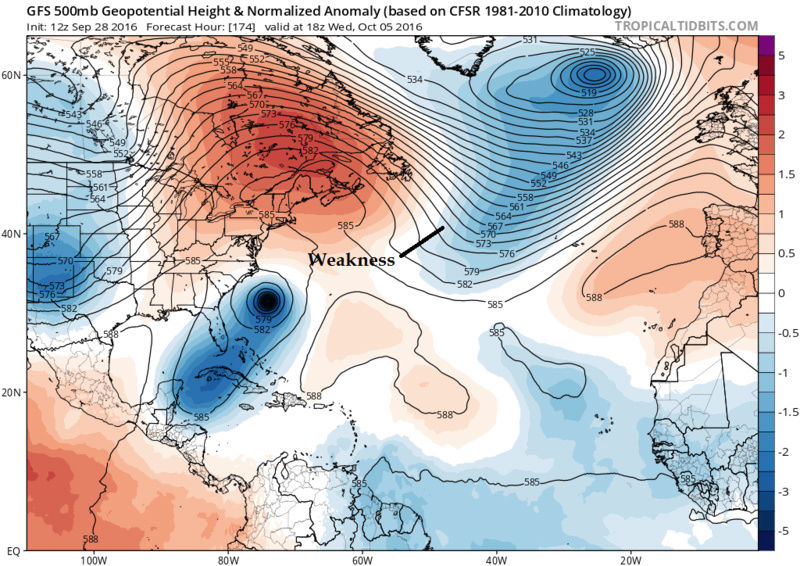
sroc4 wrote:I think for reasons Ray, (RB) mentioned this morning there remains a weakness and an escape plan OTS without a capture as per the GFS LR set up.
CMC shows similar escape route:

_________________
"In weather and in life, there's no winning and losing; there's only winning and learning."
WINTER 2012/2013 TOTALS 43.65"WINTER 2017/2018 TOTALS 62.85" WINTER 2022/2023 TOTALS 4.9"
WINTER 2013/2014 TOTALS 64.85"WINTER 2018/2019 TOTALS 14.25" WINTER 2023/2024 TOTALS 13.1"
WINTER 2014/2015 TOTALS 71.20"WINTER 2019/2020 TOTALS 6.35"
WINTER 2015/2016 TOTALS 35.00"WINTER 2020/2021 TOTALS 37.75"
WINTER 2016/2017 TOTALS 42.25"WINTER 2021/2022 TOTALS 31.65"
sroc4- Admin
- Posts : 8331
Reputation : 301
Join date : 2013-01-07
Location : Wading River, LI
jmanley32- Senior Enthusiast
- Posts : 20513
Reputation : 108
Join date : 2013-12-12
Age : 42
Location : Yonkers, NY
Re: HURRICANE MATTHEW
![]() by Snow88 Wed Sep 28, 2016 1:26 pm
by Snow88 Wed Sep 28, 2016 1:26 pm
http://www.tropicaltidbits.com/analysis/models/?model=gfs-ens®ion=us&pkg=lowlocs&runtime=2016092812&fh=186&xpos=0&ypos=927
Some heavy hitters
Snow88- Senior Enthusiast
- Posts : 2193
Reputation : 4
Join date : 2013-01-09
Age : 35
Location : Brooklyn, NY
Re: HURRICANE MATTHEW
![]() by Snow88 Wed Sep 28, 2016 1:26 pm
by Snow88 Wed Sep 28, 2016 1:26 pm
jmanley32 wrote:Oy now we are talking OTS more likely?
No
They are discussing the model runs. Every option is on the table with a storm more than a week away.
Snow88- Senior Enthusiast
- Posts : 2193
Reputation : 4
Join date : 2013-01-09
Age : 35
Location : Brooklyn, NY
Re: HURRICANE MATTHEW
![]() by sroc4 Wed Sep 28, 2016 1:30 pm
by sroc4 Wed Sep 28, 2016 1:30 pm
Snow88 wrote:jmanley32 wrote:Oy now we are talking OTS more likely?
No
They are discussing the model runs. Every option is on the table with a storm more than a week away.
This ^ Thank you Tony. Anything beyond 3-5 days is all in play. From OTS to GOM track. We still have to nail down 1-3
_________________
"In weather and in life, there's no winning and losing; there's only winning and learning."
WINTER 2012/2013 TOTALS 43.65"WINTER 2017/2018 TOTALS 62.85" WINTER 2022/2023 TOTALS 4.9"
WINTER 2013/2014 TOTALS 64.85"WINTER 2018/2019 TOTALS 14.25" WINTER 2023/2024 TOTALS 13.1"
WINTER 2014/2015 TOTALS 71.20"WINTER 2019/2020 TOTALS 6.35"
WINTER 2015/2016 TOTALS 35.00"WINTER 2020/2021 TOTALS 37.75"
WINTER 2016/2017 TOTALS 42.25"WINTER 2021/2022 TOTALS 31.65"
sroc4- Admin
- Posts : 8331
Reputation : 301
Join date : 2013-01-07
Location : Wading River, LI
Re: HURRICANE MATTHEW
![]() by amugs Wed Sep 28, 2016 1:38 pm
by amugs Wed Sep 28, 2016 1:38 pm

_________________
Mugs
AKA:King: Snow Weenie
Self Proclaimed
WINTER 2014-15 : 55.12" +.02 for 6 coatings (avg. 35")
WINTER 2015-16 Total - 29.8" (Avg 35")
WINTER 2016-17 : 39.5" so far

amugs- Advanced Forecaster - Mod
- Posts : 15093
Reputation : 213
Join date : 2013-01-07
Age : 54
Location : Hillsdale,NJ
Re: HURRICANE MATTHEW
![]() by amugs Wed Sep 28, 2016 1:44 pm
by amugs Wed Sep 28, 2016 1:44 pm

_________________
Mugs
AKA:King: Snow Weenie
Self Proclaimed
WINTER 2014-15 : 55.12" +.02 for 6 coatings (avg. 35")
WINTER 2015-16 Total - 29.8" (Avg 35")
WINTER 2016-17 : 39.5" so far
amugs- Advanced Forecaster - Mod
- Posts : 15093
Reputation : 213
Join date : 2013-01-07
Age : 54
Location : Hillsdale,NJ
Re: HURRICANE MATTHEW
![]() by sroc4 Wed Sep 28, 2016 1:49 pm
by sroc4 Wed Sep 28, 2016 1:49 pm
There is considerable difficulty in predicting the likely track of what is now Invest 97L. While I am confident that this system will be deemed "Matthew" and eventually acquire hurricane status, the lack of cohesion among the numerical forecast models and ensembles makes for a tough task in deciding where, when, and if this potentially dangerous system makes landfall. The ECMWF group stalls the storm over the Bahamas before a westward lurch into the Gulf of Mexico. At this time, I am cautiously following the GFS panels with a move from NC to NY between October 7-9.
_________________
"In weather and in life, there's no winning and losing; there's only winning and learning."
WINTER 2012/2013 TOTALS 43.65"WINTER 2017/2018 TOTALS 62.85" WINTER 2022/2023 TOTALS 4.9"
WINTER 2013/2014 TOTALS 64.85"WINTER 2018/2019 TOTALS 14.25" WINTER 2023/2024 TOTALS 13.1"
WINTER 2014/2015 TOTALS 71.20"WINTER 2019/2020 TOTALS 6.35"
WINTER 2015/2016 TOTALS 35.00"WINTER 2020/2021 TOTALS 37.75"
WINTER 2016/2017 TOTALS 42.25"WINTER 2021/2022 TOTALS 31.65"
sroc4- Admin
- Posts : 8331
Reputation : 301
Join date : 2013-01-07
Location : Wading River, LI
Re: HURRICANE MATTHEW
![]() by amugs Wed Sep 28, 2016 1:51 pm
by amugs Wed Sep 28, 2016 1:51 pm
All I can say is this is very exciting if you're a weenie.
_________________
Mugs
AKA:King: Snow Weenie
Self Proclaimed
WINTER 2014-15 : 55.12" +.02 for 6 coatings (avg. 35")
WINTER 2015-16 Total - 29.8" (Avg 35")
WINTER 2016-17 : 39.5" so far
amugs- Advanced Forecaster - Mod
- Posts : 15093
Reputation : 213
Join date : 2013-01-07
Age : 54
Location : Hillsdale,NJ
Re: HURRICANE MATTHEW
![]() by sroc4 Wed Sep 28, 2016 2:02 pm
by sroc4 Wed Sep 28, 2016 2:02 pm
amugs wrote:Very intriguing solutions and the points I made will be at playas we get closer- this is going to be a fun one. I bet all tv mets side with climo and say OTS - they did the same with Sandy even though we had a frickin mega block over Greenland - they were riding the GFS until about 36 hours before.
All I can say is this is very exciting if you're a weenie.
You said it Brother!!
_________________
"In weather and in life, there's no winning and losing; there's only winning and learning."
WINTER 2012/2013 TOTALS 43.65"WINTER 2017/2018 TOTALS 62.85" WINTER 2022/2023 TOTALS 4.9"
WINTER 2013/2014 TOTALS 64.85"WINTER 2018/2019 TOTALS 14.25" WINTER 2023/2024 TOTALS 13.1"
WINTER 2014/2015 TOTALS 71.20"WINTER 2019/2020 TOTALS 6.35"
WINTER 2015/2016 TOTALS 35.00"WINTER 2020/2021 TOTALS 37.75"
WINTER 2016/2017 TOTALS 42.25"WINTER 2021/2022 TOTALS 31.65"
sroc4- Admin
- Posts : 8331
Reputation : 301
Join date : 2013-01-07
Location : Wading River, LI
Re: HURRICANE MATTHEW
![]() by sroc4 Wed Sep 28, 2016 2:12 pm
by sroc4 Wed Sep 28, 2016 2:12 pm


_________________
"In weather and in life, there's no winning and losing; there's only winning and learning."
WINTER 2012/2013 TOTALS 43.65"WINTER 2017/2018 TOTALS 62.85" WINTER 2022/2023 TOTALS 4.9"
WINTER 2013/2014 TOTALS 64.85"WINTER 2018/2019 TOTALS 14.25" WINTER 2023/2024 TOTALS 13.1"
WINTER 2014/2015 TOTALS 71.20"WINTER 2019/2020 TOTALS 6.35"
WINTER 2015/2016 TOTALS 35.00"WINTER 2020/2021 TOTALS 37.75"
WINTER 2016/2017 TOTALS 42.25"WINTER 2021/2022 TOTALS 31.65"
sroc4- Admin
- Posts : 8331
Reputation : 301
Join date : 2013-01-07
Location : Wading River, LI
Re: HURRICANE MATTHEW
![]() by jmanley32 Wed Sep 28, 2016 2:13 pm
by jmanley32 Wed Sep 28, 2016 2:13 pm
jmanley32- Senior Enthusiast
- Posts : 20513
Reputation : 108
Join date : 2013-12-12
Age : 42
Location : Yonkers, NY
Page 9 of 32 • 1 ... 6 ... 8, 9, 10 ... 20 ... 32 ![]()
|
|
|