
 Search
FRIDAY MARCH 10th 2017: Discussions & Observations
Page 2 of 11 •  1, 2, 3, ... 9, 10, 11
 ![]()

amugs- Advanced Forecaster - Mod

- Posts : 15095
Join date : 2013-01-07
Re: FRIDAY MARCH 10th 2017: Discussions & Observations
![]() by SoulSingMG Thu Mar 09, 2017 11:07 am
by SoulSingMG Thu Mar 09, 2017 11:07 am
SoulSingMG- Senior Enthusiast

- Posts : 2853
Join date : 2013-12-11
Re: FRIDAY MARCH 10th 2017: Discussions & Observations
![]() by Frank_Wx Thu Mar 09, 2017 11:23 am
by Frank_Wx Thu Mar 09, 2017 11:23 am
le88kb wrote:When will you guys have final maps ?
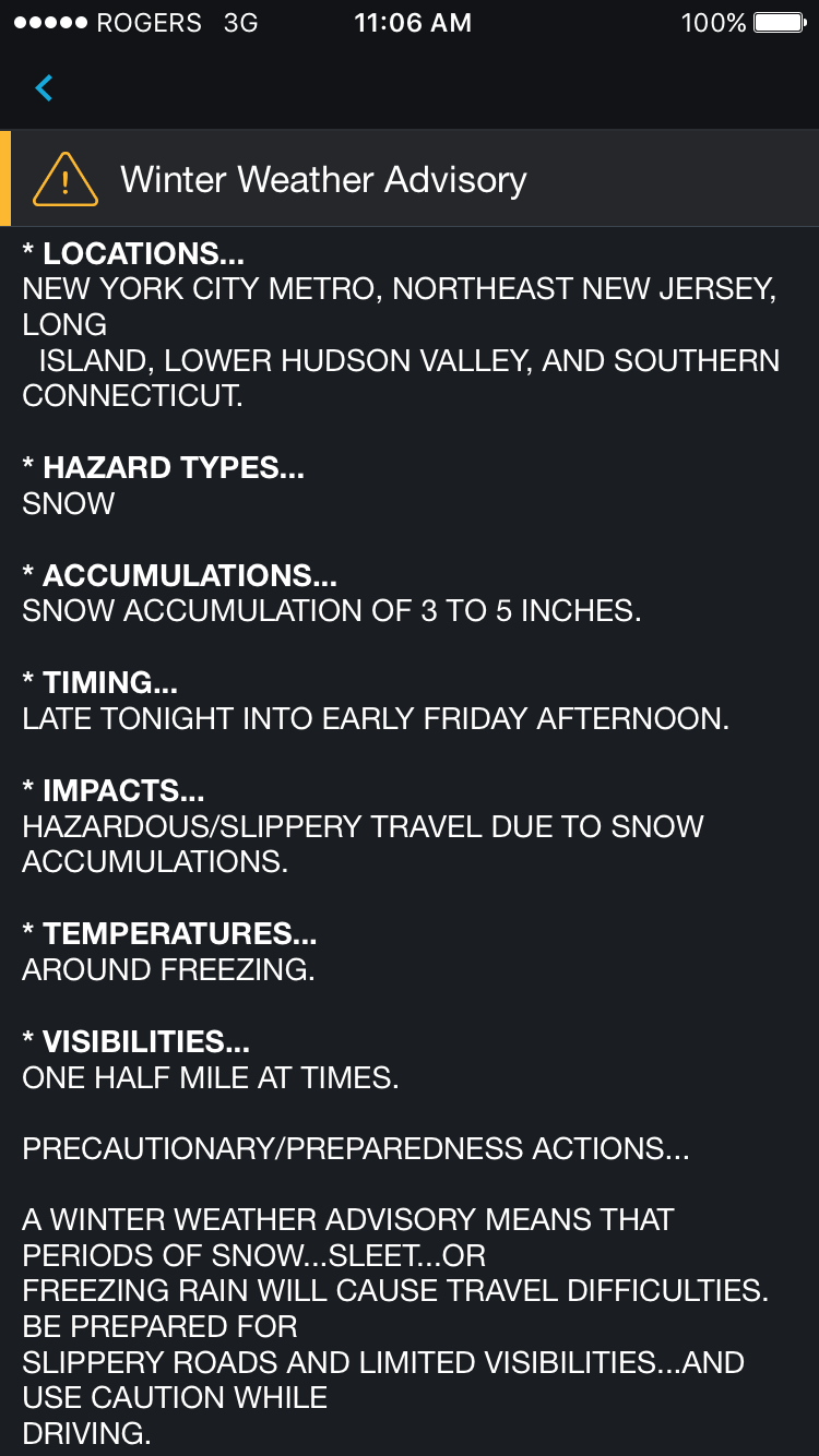
No map from me. I agree with Scott's map and my thought's are in the scroll. General 3-6" area wide with locally higher amounts.
_________________
_______________________________________________________________________________________________________
CLICK HERE to view NJ Strong Snowstorm Classifications

Frank_Wx- Godzilla Seeker

- Posts : 21305
Reputation : 328
Join date : 2013-01-05
Age : 32
Location : Jersey City, NJ -

Re: FRIDAY MARCH 10th 2017: Discussions & Observations
![]() by amugs Thu Mar 09, 2017 12:02 pm
by amugs Thu Mar 09, 2017 12:02 pm

_________________
Mugs
AKA:King: Snow Weenie
Self Proclaimed
WINTER 2014-15 : 55.12" +.02 for 6 coatings (avg. 35")
WINTER 2015-16 Total - 29.8" (Avg 35")
WINTER 2016-17 : 39.5" so far

amugs- Advanced Forecaster - Mod
- Posts : 15095
Reputation : 213
Join date : 2013-01-07
Age : 54
Location : Hillsdale,NJ
Re: FRIDAY MARCH 10th 2017: Discussions & Observations
![]() by SENJsnowman Thu Mar 09, 2017 12:09 pm
by SENJsnowman Thu Mar 09, 2017 12:09 pm
SENJsnowman- Senior Enthusiast
- Posts : 1189
Reputation : 61
Join date : 2017-01-06
Age : 51
Location : Bayville, NJ
Re: FRIDAY MARCH 10th 2017: Discussions & Observations
![]() by sroc4 Thu Mar 09, 2017 12:18 pm
by sroc4 Thu Mar 09, 2017 12:18 pm
SENJsnowman wrote:Well, obviously this looks awesome (INCREDIBLY AWESOME actually)...but could a much stronger Wave 1 interfere with Tuesday, by screwing with the blocking or something like that?
It might actually enhace it
_________________
"In weather and in life, there's no winning and losing; there's only winning and learning."
WINTER 2012/2013 TOTALS 43.65"WINTER 2017/2018 TOTALS 62.85" WINTER 2022/2023 TOTALS 4.9"
WINTER 2013/2014 TOTALS 64.85"WINTER 2018/2019 TOTALS 14.25" WINTER 2023/2024 TOTALS 13.1"
WINTER 2014/2015 TOTALS 71.20"WINTER 2019/2020 TOTALS 6.35"
WINTER 2015/2016 TOTALS 35.00"WINTER 2020/2021 TOTALS 37.75"
WINTER 2016/2017 TOTALS 42.25"WINTER 2021/2022 TOTALS 31.65"

sroc4- Admin
- Posts : 8354
Reputation : 302
Join date : 2013-01-07
Location : Wading River, LI
Re: FRIDAY MARCH 10th 2017: Discussions & Observations
![]() by SENJsnowman Thu Mar 09, 2017 12:23 pm
by SENJsnowman Thu Mar 09, 2017 12:23 pm
sroc4 wrote:SENJsnowman wrote:Well, obviously this looks awesome (INCREDIBLY AWESOME actually)...but could a much stronger Wave 1 interfere with Tuesday, by screwing with the blocking or something like that?
It might actually enhace it
SENJsnowman- Senior Enthusiast
- Posts : 1189
Reputation : 61
Join date : 2017-01-06
Age : 51
Location : Bayville, NJ
Re: FRIDAY MARCH 10th 2017: Discussions & Observations
![]() by mikeypizano Thu Mar 09, 2017 12:24 pm
by mikeypizano Thu Mar 09, 2017 12:24 pm

mikeypizano- Pro Enthusiast

- Posts : 1118
Reputation : 66
Join date : 2017-01-05
Age : 35
Location : Wilkes-Barre/Scranton, PA
Re: FRIDAY MARCH 10th 2017: Discussions & Observations
![]() by CPcantmeasuresnow Thu Mar 09, 2017 12:29 pm
by CPcantmeasuresnow Thu Mar 09, 2017 12:29 pm
amugs wrote:UKIE DROPPED THE MIC...............
Basically a half inch of qpf through most of the area almost 3/4 in a couple of spots, should translate to 3-6 like Frank and SROC have been saying unless ratios improve?

CPcantmeasuresnow- Wx Statistician Guru

- Posts : 7274
Reputation : 230
Join date : 2013-01-07
Age : 103
Location : Eastern Orange County, NY
Re: FRIDAY MARCH 10th 2017: Discussions & Observations
![]() by amugs Thu Mar 09, 2017 12:29 pm
by amugs Thu Mar 09, 2017 12:29 pm

Mean Percip close up - WOW for this storm!

850's

_________________
Mugs
AKA:King: Snow Weenie
Self Proclaimed
WINTER 2014-15 : 55.12" +.02 for 6 coatings (avg. 35")
WINTER 2015-16 Total - 29.8" (Avg 35")
WINTER 2016-17 : 39.5" so far
amugs- Advanced Forecaster - Mod
- Posts : 15095
Reputation : 213
Join date : 2013-01-07
Age : 54
Location : Hillsdale,NJ
Re: FRIDAY MARCH 10th 2017: Discussions & Observations
![]() by amugs Thu Mar 09, 2017 12:30 pm
by amugs Thu Mar 09, 2017 12:30 pm
_________________
Mugs
AKA:King: Snow Weenie
Self Proclaimed
WINTER 2014-15 : 55.12" +.02 for 6 coatings (avg. 35")
WINTER 2015-16 Total - 29.8" (Avg 35")
WINTER 2016-17 : 39.5" so far
amugs- Advanced Forecaster - Mod
- Posts : 15095
Reputation : 213
Join date : 2013-01-07
Age : 54
Location : Hillsdale,NJ
Re: FRIDAY MARCH 10th 2017: Discussions & Observations
![]() by Nyi1058 Thu Mar 09, 2017 12:36 pm
by Nyi1058 Thu Mar 09, 2017 12:36 pm
Nyi1058- Posts : 86
Reputation : 3
Join date : 2013-12-04
Age : 49
Location : Port Jefferson Long Island
Re: FRIDAY MARCH 10th 2017: Discussions & Observations
![]() by CPcantmeasuresnow Thu Mar 09, 2017 12:44 pm
by CPcantmeasuresnow Thu Mar 09, 2017 12:44 pm
amugs wrote:15MM to 20MM is .4 - 6" of qpf so basically 3 low end to 6/7 high end.
15MM is .6 and 20MM is .8.
A lot of the area is in the 10MM-15MM shade which would be .4 to .6, not sure if that's what you were trying too say. Snow seems to get you all excited, I wonder why
CPcantmeasuresnow- Wx Statistician Guru
- Posts : 7274
Reputation : 230
Join date : 2013-01-07
Age : 103
Location : Eastern Orange County, NY
Re: FRIDAY MARCH 10th 2017: Discussions & Observations
![]() by SNOW MAN Thu Mar 09, 2017 12:57 pm
by SNOW MAN Thu Mar 09, 2017 12:57 pm
CPcantmeasuresnow wrote:amugs wrote:15MM to 20MM is .4 - 6" of qpf so basically 3 low end to 6/7 high end.
15MM is .6 and 20MM is .8.
A lot of the area is in the 10MM-15MM shade which would be .4 to .6, not sure if that's what you were trying too say. Snow seems to get you all excited, I wonder why, so I didn't know if it was a typo.
Cp, he seems to do that a lot. (12-24' ?)

SNOW MAN- Senior Enthusiast
- Posts : 1361
Reputation : 25
Join date : 2013-01-13
Age : 64
Location : Marshalls Creek Pa.
Re: FRIDAY MARCH 10th 2017: Discussions & Observations
![]() by amugs Thu Mar 09, 2017 12:59 pm
by amugs Thu Mar 09, 2017 12:59 pm
LOL
_________________
Mugs
AKA:King: Snow Weenie
Self Proclaimed
WINTER 2014-15 : 55.12" +.02 for 6 coatings (avg. 35")
WINTER 2015-16 Total - 29.8" (Avg 35")
WINTER 2016-17 : 39.5" so far
amugs- Advanced Forecaster - Mod
- Posts : 15095
Reputation : 213
Join date : 2013-01-07
Age : 54
Location : Hillsdale,NJ
Re: FRIDAY MARCH 10th 2017: Discussions & Observations
![]() by mikeypizano Thu Mar 09, 2017 1:01 pm
by mikeypizano Thu Mar 09, 2017 1:01 pm
mikeypizano- Pro Enthusiast
- Posts : 1118
Reputation : 66
Join date : 2017-01-05
Age : 35
Location : Wilkes-Barre/Scranton, PA
Re: FRIDAY MARCH 10th 2017: Discussions & Observations
![]() by SNOW MAN Thu Mar 09, 2017 1:02 pm
by SNOW MAN Thu Mar 09, 2017 1:02 pm
amugs wrote:Cp - yes I was typing as I am here grading etc. sorry peeps - 12-24' you complaining SNOW MAN hmm??
LOL
NOPE.
SNOW MAN- Senior Enthusiast
- Posts : 1361
Reputation : 25
Join date : 2013-01-13
Age : 64
Location : Marshalls Creek Pa.
Re: FRIDAY MARCH 10th 2017: Discussions & Observations
![]() by Dtone Thu Mar 09, 2017 1:03 pm
by Dtone Thu Mar 09, 2017 1:03 pm
syosnow94 wrote:I think this is the kind of event where colder surfaces for obvious reasons get 3-5" while the paved surfaces remain slushy at best!!! This will lead to really difficult decisions regarding school openings on LI. I feel like there will be many 2 hour delays. NYC metro and the 5 boroughs probably will not see any accumulations at all due to the heat island. 4" puts me at 40" which would be miraculous.
ugh that UHI. March snowfalls are notorious for that. Scenarios like 0.2" on the NY side of the GWB but 3" in Ft Lee, then several inches going beyond that. Accumulations on only colder surfaces in the city is effectively no snow, unless your in a city park. One of the few situations where Central Park will measure more snow than what is actually encountered throughout NYC neighborhoods. The NWS says temps will be mostly steady in the low 30s while many other outlets calling for mostly upper 30s. Maybe nws is on to something
Dtone- Wx Statistician Guru
- Posts : 1738
Reputation : 9
Join date : 2013-08-26
Location : Bronx, NY
Re: FRIDAY MARCH 10th 2017: Discussions & Observations
![]() by jmanley32 Thu Mar 09, 2017 1:04 pm
by jmanley32 Thu Mar 09, 2017 1:04 pm
amugs wrote:GEFS for wave one -
Mean Percip close up - WOW for this storm!
850's
mugs top snow map is through hr 180, includes tuesday.

jmanley32- Senior Enthusiast
- Posts : 20535
Reputation : 108
Join date : 2013-12-12
Age : 43
Location : Yonkers, NY
Re: FRIDAY MARCH 10th 2017: Discussions & Observations
![]() by Frank_Wx Thu Mar 09, 2017 1:35 pm
by Frank_Wx Thu Mar 09, 2017 1:35 pm
_________________
_______________________________________________________________________________________________________
CLICK HERE to view NJ Strong Snowstorm Classifications
Frank_Wx- Godzilla Seeker
- Posts : 21305
Reputation : 328
Join date : 2013-01-05
Age : 32
Location : Jersey City, NJ -
Re: FRIDAY MARCH 10th 2017: Discussions & Observations
![]() by rb924119 Thu Mar 09, 2017 1:45 pm
by rb924119 Thu Mar 09, 2017 1:45 pm
Unfortunately, there won't be enough time for a map like normal, but expect a general 3-5" in the zone between I-84 on the north side and a line from Sandy Hook, NJ southwestward through Harrisburg, Pa on the south side. On the north side of that zone, there will be a very sharp cutoff in the snow within about 25 or 30 miles, such that outside those 25 or 30 miles don't expect much more than a dusting at most. To the south side of the 3-5" zone, warmer ground and air temperatures coupled with the dry nature of the snow should largely work to limit accumulations, even though the heavier snow will be across this region. Therefore, between the Sandy Hook-Harrisburg line and approximately along a line from the Mason-Dixon toward Island Beach State Park, I am expecting 1-3", with less than 1" south of there. If you're having trouble visualizing, generally the elevated areas north and west of I-95 and south and east of I-84 should receive the 3-5", with less than that elsewhere, put simply. Sorry for the lack of graphic!!
rb924119- Meteorologist

- Posts : 6928
Reputation : 194
Join date : 2013-02-06
Age : 32
Location : Greentown, Pa
Re: FRIDAY MARCH 10th 2017: Discussions & Observations
![]() by amugs Thu Mar 09, 2017 1:50 pm
by amugs Thu Mar 09, 2017 1:50 pm
_________________
Mugs
AKA:King: Snow Weenie
Self Proclaimed
WINTER 2014-15 : 55.12" +.02 for 6 coatings (avg. 35")
WINTER 2015-16 Total - 29.8" (Avg 35")
WINTER 2016-17 : 39.5" so far
amugs- Advanced Forecaster - Mod
- Posts : 15095
Reputation : 213
Join date : 2013-01-07
Age : 54
Location : Hillsdale,NJ
Re: FRIDAY MARCH 10th 2017: Discussions & Observations
![]() by Frank_Wx Thu Mar 09, 2017 2:13 pm
by Frank_Wx Thu Mar 09, 2017 2:13 pm
rb924119 wrote:Haven't had much time to devote, so this may not work out too well (not to mention my AccuWeather Pro subscription expired on me!!!! So I'm without many of my go-to graphics >_<) Be as that may, here's a brief post ripped from my FaceBook:
Unfortunately, there won't be enough time for a map like normal, but expect a general 3-5" in the zone between I-84 on the north side and a line from Sandy Hook, NJ southwestward through Harrisburg, Pa on the south side. On the north side of that zone, there will be a very sharp cutoff in the snow within about 25 or 30 miles, such that outside those 25 or 30 miles don't expect much more than a dusting at most. To the south side of the 3-5" zone, warmer ground and air temperatures coupled with the dry nature of the snow should largely work to limit accumulations, even though the heavier snow will be across this region. Therefore, between the Sandy Hook-Harrisburg line and approximately along a line from the Mason-Dixon toward Island Beach State Park, I am expecting 1-3", with less than 1" south of there. If you're having trouble visualizing, generally the elevated areas north and west of I-95 and south and east of I-84 should receive the 3-5", with less than that elsewhere, put simply. Sorry for the lack of graphic!!
I am without all my subscriptions too. We're in the same boat.
_________________
_______________________________________________________________________________________________________
CLICK HERE to view NJ Strong Snowstorm Classifications
Frank_Wx- Godzilla Seeker
- Posts : 21305
Reputation : 328
Join date : 2013-01-05
Age : 32
Location : Jersey City, NJ -
Re: FRIDAY MARCH 10th 2017: Discussions & Observations
![]() by jake732 Thu Mar 09, 2017 2:46 pm
by jake732 Thu Mar 09, 2017 2:46 pm
Plz read and share with friends!! comment on it as im trying to get better and better and im looking for opinions

jake732- Pro Enthusiast
- Posts : 449
Reputation : 0
Join date : 2016-01-03
Location : lakewood, nj -
Re: FRIDAY MARCH 10th 2017: Discussions & Observations
![]() by jake732 Thu Mar 09, 2017 2:52 pm
by jake732 Thu Mar 09, 2017 2:52 pm
Plz read and share with friends!! comment on it as im trying to get better and better and im looking for opinions
jake732- Pro Enthusiast
- Posts : 449
Reputation : 0
Join date : 2016-01-03
Location : lakewood, nj -
Re: FRIDAY MARCH 10th 2017: Discussions & Observations
![]() by billg315 Thu Mar 09, 2017 3:12 pm
by billg315 Thu Mar 09, 2017 3:12 pm
jake732 wrote:http://www.lakewood732.com/2017/03/friday-march-10th.html
Plz read and share with friends!! comment on it as im trying to get better and better and im looking for opinions
Looks good Jake. I also tend to agree that the warm surface temperatures are going to disappoint us a bit in terms of how much snow actually piles up tomorrow.

billg315- Advanced Forecaster - Mod
- Posts : 4483
Reputation : 185
Join date : 2015-01-24
Age : 50
Location : Flemington, NJ
Re: FRIDAY MARCH 10th 2017: Discussions & Observations
![]() by SENJsnowman Thu Mar 09, 2017 3:15 pm
by SENJsnowman Thu Mar 09, 2017 3:15 pm
SENJsnowman- Senior Enthusiast
- Posts : 1189
Reputation : 61
Join date : 2017-01-06
Age : 51
Location : Bayville, NJ
Page 2 of 11 • 1, 2, 3, ... 9, 10, 11 ![]()
|
|
|