
 Search
BLOG: Roidzilla Could Impact Area Tuesday March 14th
Page 22 of 25 •  1 ... 12 ... 21, 22, 23, 24, 25
 ![]()
Re: BLOG: Roidzilla Could Impact Area Tuesday March 14th
![]() by sroc4 Sat Mar 11, 2017 7:45 am
by sroc4 Sat Mar 11, 2017 7:45 am
nutleyblizzard wrote:I also have that same fear too JMan. Most of us lived through that god awful heartbreak with March 2001 when models were in agreement inside 3 days for a historic event only to fail miserably. That event has taught me too temper my expectations with any snow threat. As each model run commences and we get closer to the event, the tension will rise. Today's 12z suite and more so tonights 00Z runs will be unbearable. In my opinion, if we are able to hold serve by Sunday's 12z suite, we will be good to go.jmanley32 wrote:do u really think with Franks level of excitement and confidence tgat tgat is a issue? This storm is coming no dpubt and I am nodding towars all or nearly all snow as are many mets.Grselig wrote:I keep on waiting for the shoe to fall and we get rain or nothing. But based on last nights Euro and NWS diso etc it seems like the laces are tightening. Amazing.
The Pacific energy will not be fully onshore until 00z and 06z Sunday. Same with the polar energy and the energy in the STJ. If we are going to see the late trends in the models its between now and 12z tomorrow. Eggs shells for sure. Its no longer a matter of if, but rather, how much.
sroc4- Admin

- Posts : 8354
Join date : 2013-01-07
Re: BLOG: Roidzilla Could Impact Area Tuesday March 14th
![]() by Grselig Sat Mar 11, 2017 7:49 am
by Grselig Sat Mar 11, 2017 7:49 am
jmanley32 wrote:do u really think with Franks level of excitement and confidence that that all rsin or ots is sn issue? This storm is coming no doubt and I am nodding towards all or nearly all snow as are many mets.Grselig wrote:I keep on waiting for the shoe to fall and we get rain or nothing. But based on last nights Euro and NWS diso etc it seems like the laces are tightening. Amazing.
It defies logic but as others have said, we've all been burned in the past. We've been tracking this a week out and things sometimes disappear (AND COME BACK STRONG). A deal is never done till its done. I don't think I have ever seen Frank and other very very knowledgabe this confident about a storm at this stage in the game. Yes, its eggshells until it happens!!
Last edited by Grselig on Sat Mar 11, 2017 7:53 am; edited 1 time in total
Grselig- Senior Enthusiast

- Posts : 1408
Join date : 2013-03-04
Re: BLOG: Roidzilla Could Impact Area Tuesday March 14th
![]() by SENJsnowman Sat Mar 11, 2017 7:50 am
by SENJsnowman Sat Mar 11, 2017 7:50 am
nutleyblizzard wrote:I also have that same fear too JMan. Most of us lived through that god awful heartbreak with March 2001 when models were in agreement inside 3 days for a historic event only to fail miserably. That event has taught me too temper my expectations with any snow threat. As each model run commences and we get closer to the event, the tension will rise. Today's 12z suite and more so tonights 00Z runs will be unbearable. In my opinion, if we are able to hold serve by Sunday's 12z suite, we will be good to go.jmanley32 wrote:do u really think with Franks level of excitement and confidence tgat tgat is a issue? This storm is coming no dpubt and I am nodding towars all or nearly all snow as are many mets.Grselig wrote:I keep on waiting for the shoe to fall and we get rain or nothing. But based on last nights Euro and NWS diso etc it seems like the laces are tightening. Amazing.
Not to mention the heartbreak of Jan 2015 for many of us. For 3 days, it was a matter of how many feet. I'll never forget Nick Gregory's final call map. He had this large swath of pure white across the whole NYC metro area: 2-3 feet! And this was at 6 pm the night of! Alas, the storm kicked too far east and the snow bands got destroyed on the way back to the shore. Northern regions (esp. NE) did just fine, but most of our whole area got 6" of backend snow and nothing else.
The moral of the story: It's looking good and it may yet look even better, just don't count them chickens!
SENJsnowman- Senior Enthusiast
- Posts : 1189
Reputation : 61
Join date : 2017-01-06
Age : 51
Location : Bayville, NJ
Re: BLOG: Roidzilla Could Impact Area Tuesday March 14th
![]() by billg315 Sat Mar 11, 2017 7:52 am
by billg315 Sat Mar 11, 2017 7:52 am

billg315- Advanced Forecaster - Mod

- Posts : 4483
Reputation : 185
Join date : 2015-01-24
Age : 50
Location : Flemington, NJ
Re: BLOG: Roidzilla Could Impact Area Tuesday March 14th
![]() by RJB8525 Sat Mar 11, 2017 7:53 am
by RJB8525 Sat Mar 11, 2017 7:53 am
Frank_Wx wrote:

OY VEY
This took me a few minutes to do from my phone.

RJB8525- Senior Enthusiast
- Posts : 1994
Reputation : 28
Join date : 2013-02-06
Age : 38
Location : Hackettstown, NJ
Re: BLOG: Roidzilla Could Impact Area Tuesday March 14th
![]() by jmanley32 Sat Mar 11, 2017 8:11 am
by jmanley32 Sat Mar 11, 2017 8:11 am

jmanley32- Senior Enthusiast
- Posts : 20535
Reputation : 108
Join date : 2013-12-12
Age : 43
Location : Yonkers, NY
Re: BLOG: Roidzilla Could Impact Area Tuesday March 14th
![]() by Grselig Sat Mar 11, 2017 8:16 am
by Grselig Sat Mar 11, 2017 8:16 am
jmanley32 wrote:Even accuwx app has already 5 to 11 inches with 40mph winds and often even though they are bullish not that 2 or more days away!
I fear the mad rush to Home Depot and the grocery store will begin today. I got my salt from BJ's yesterday!

Grselig- Senior Enthusiast
- Posts : 1408
Reputation : 140
Join date : 2013-03-04
Age : 54
Location : Wayne NJ
Re: BLOG: Roidzilla Could Impact Area Tuesday March 14th
![]() by skinsfan1177 Sat Mar 11, 2017 8:16 am
by skinsfan1177 Sat Mar 11, 2017 8:16 am


skinsfan1177- Senior Enthusiast
- Posts : 4485
Reputation : 35
Join date : 2013-01-07
Age : 46
Location : Point Pleasant Boro
Re: BLOG: Roidzilla Could Impact Area Tuesday March 14th
![]() by Frank_Wx Sat Mar 11, 2017 8:20 am
by Frank_Wx Sat Mar 11, 2017 8:20 am

_________________
_______________________________________________________________________________________________________
CLICK HERE to view NJ Strong Snowstorm Classifications

Frank_Wx- Godzilla Seeker
- Posts : 21305
Reputation : 328
Join date : 2013-01-05
Age : 32
Location : Jersey City, NJ -

Re: BLOG: Roidzilla Could Impact Area Tuesday March 14th
![]() by frank 638 Sat Mar 11, 2017 8:26 am
by frank 638 Sat Mar 11, 2017 8:26 am
frank 638- Senior Enthusiast
- Posts : 2843
Reputation : 37
Join date : 2016-01-01
Age : 40
Location : bronx ny
Re: BLOG: Roidzilla Could Impact Area Tuesday March 14th
![]() by mikeypizano Sat Mar 11, 2017 8:30 am
by mikeypizano Sat Mar 11, 2017 8:30 am

mikeypizano- Pro Enthusiast

- Posts : 1118
Reputation : 66
Join date : 2017-01-05
Age : 35
Location : Wilkes-Barre/Scranton, PA
Re: BLOG: Roidzilla Could Impact Area Tuesday March 14th
![]() by SENJsnowman Sat Mar 11, 2017 8:30 am
by SENJsnowman Sat Mar 11, 2017 8:30 am
SENJsnowman- Senior Enthusiast
- Posts : 1189
Reputation : 61
Join date : 2017-01-06
Age : 51
Location : Bayville, NJ
Re: BLOG: Roidzilla Could Impact Area Tuesday March 14th
![]() by frank 638 Sat Mar 11, 2017 8:32 am
by frank 638 Sat Mar 11, 2017 8:32 am
frank 638- Senior Enthusiast
- Posts : 2843
Reputation : 37
Join date : 2016-01-01
Age : 40
Location : bronx ny
Re: BLOG: Roidzilla Could Impact Area Tuesday March 14th
![]() by RJB8525 Sat Mar 11, 2017 8:33 am
by RJB8525 Sat Mar 11, 2017 8:33 am
mikeypizano wrote:I vote on naming this storm... Winter Storm... STUGOTS!
STUGOTS
RJB8525- Senior Enthusiast
- Posts : 1994
Reputation : 28
Join date : 2013-02-06
Age : 38
Location : Hackettstown, NJ
Re: BLOG: Roidzilla Could Impact Area Tuesday March 14th
![]() by rb924119 Sat Mar 11, 2017 8:34 am
by rb924119 Sat Mar 11, 2017 8:34 am
rb924119- Meteorologist

- Posts : 6928
Reputation : 194
Join date : 2013-02-06
Age : 32
Location : Greentown, Pa
Re: BLOG: Roidzilla Could Impact Area Tuesday March 14th
![]() by skinsfan1177 Sat Mar 11, 2017 8:44 am
by skinsfan1177 Sat Mar 11, 2017 8:44 am
Frank_Wx wrote:SREFs are very nice. They lean just inside the BM. Man oh man this will be very close for the coast. Gotta smell the rain to see the heavy snow though. Whoever is just west of the r/s line will see Roidzilla amounts.
Many people along the coast think it won't be much here I think they are wrong. Even with mixing issues don't you think its still a big hit?
skinsfan1177- Senior Enthusiast
- Posts : 4485
Reputation : 35
Join date : 2013-01-07
Age : 46
Location : Point Pleasant Boro
Re: BLOG: Roidzilla Could Impact Area Tuesday March 14th
![]() by Guest Sat Mar 11, 2017 8:44 am
by Guest Sat Mar 11, 2017 8:44 am
rb924119 wrote:You know, I'm almost wondering if this could just end up looking more like a juiced up front. Not saying it will, just saying that I can see how it could go to that, and not really ball up with a classic comma-head structure until it reaches northern New England.
What differences are there in terms of sensible weather?
Guest- Guest
Re: BLOG: Roidzilla Could Impact Area Tuesday March 14th
![]() by jmanley32 Sat Mar 11, 2017 8:49 am
by jmanley32 Sat Mar 11, 2017 8:49 am
so the euro has moved more towards coastal hugger ehile gefs are a bit further offshore. Switcheroo or a median meetup?skinsfan1177 wrote:Gefs have corrected and gone to euro look. Also here is the euro mean a lot of left leaners
jmanley32- Senior Enthusiast
- Posts : 20535
Reputation : 108
Join date : 2013-12-12
Age : 43
Location : Yonkers, NY
Re: BLOG: Roidzilla Could Impact Area Tuesday March 14th
![]() by rb924119 Sat Mar 11, 2017 8:51 am
by rb924119 Sat Mar 11, 2017 8:51 am
TheAresian wrote:rb924119 wrote:You know, I'm almost wondering if this could just end up looking more like a juiced up front. Not saying it will, just saying that I can see how it could go to that, and not really ball up with a classic comma-head structure until it reaches northern New England.
What differences are there in terms of sensible weather?
Shorter storm with lower totals, but a true "fast and furious" event. Chances of coastal mixing would also likely be increased.
rb924119- Meteorologist
- Posts : 6928
Reputation : 194
Join date : 2013-02-06
Age : 32
Location : Greentown, Pa
Re: BLOG: Roidzilla Could Impact Area Tuesday March 14th
![]() by skinsfan1177 Sat Mar 11, 2017 8:52 am
by skinsfan1177 Sat Mar 11, 2017 8:52 am
No I think euro is just inside benchmark GFS is coastal hugger but like frank I think mentioned the GEFS ensembles were east in other words GFS is in its own camp.jmanley32 wrote:so the euro has moved more towards coastal hugger ehile gefs are a bit further offshore. Switcheroo or a median meetup?skinsfan1177 wrote:Gefs have corrected and gone to euro look. Also here is the euro mean a lot of left leaners
skinsfan1177- Senior Enthusiast
- Posts : 4485
Reputation : 35
Join date : 2013-01-07
Age : 46
Location : Point Pleasant Boro
Re: BLOG: Roidzilla Could Impact Area Tuesday March 14th
![]() by jmanley32 Sat Mar 11, 2017 8:53 am
by jmanley32 Sat Mar 11, 2017 8:53 am
jmanley32- Senior Enthusiast
- Posts : 20535
Reputation : 108
Join date : 2013-12-12
Age : 43
Location : Yonkers, NY
Re: BLOG: Roidzilla Could Impact Area Tuesday March 14th
![]() by SENJsnowman Sat Mar 11, 2017 8:53 am
by SENJsnowman Sat Mar 11, 2017 8:53 am
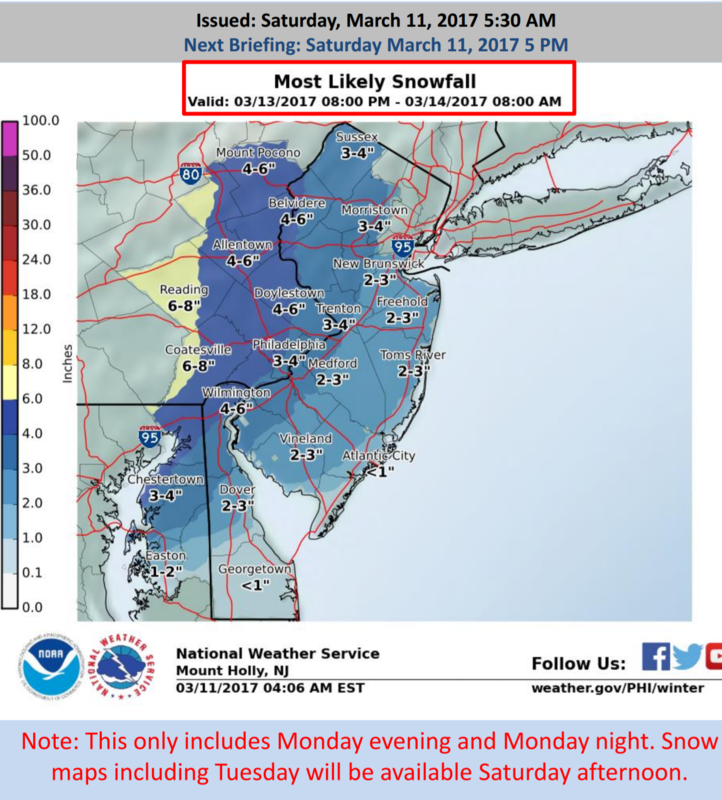
frank 638 wrote:Even AccuWeather has me for 6 to 10 inches of snow for Tues into wed .
WOW...I just checked Accu for my local forecast: 8-12"! I think I'd give up some of the higher end potential for some certainty as to all snow...
SENJsnowman- Senior Enthusiast
- Posts : 1189
Reputation : 61
Join date : 2017-01-06
Age : 51
Location : Bayville, NJ
Re: BLOG: Roidzilla Could Impact Area Tuesday March 14th
![]() by Guest Sat Mar 11, 2017 8:56 am
by Guest Sat Mar 11, 2017 8:56 am
Guest- Guest
Re: BLOG: Roidzilla Could Impact Area Tuesday March 14th
![]() by Armando Salvadore Sat Mar 11, 2017 8:57 am
by Armando Salvadore Sat Mar 11, 2017 8:57 am

Armando Salvadore- Advanced Forecaster

- Posts : 171
Reputation : 0
Join date : 2016-12-23
Location : Springfield, NJ
Re: BLOG: Roidzilla Could Impact Area Tuesday March 14th
![]() by jmanley32 Sat Mar 11, 2017 8:58 am
by jmanley32 Sat Mar 11, 2017 8:58 am
Its early 8 to 12 is high at this juncture it will go up. Posdibly way up.SENJsnowman wrote:frank 638 wrote:Even AccuWeather has me for 6 to 10 inches of snow for Tues into wed .
WOW...I just checked Accu for my local forecast: 8-12"! I think I'd give up some of the higher end potential for some certainty as to all snow...
jmanley32- Senior Enthusiast
- Posts : 20535
Reputation : 108
Join date : 2013-12-12
Age : 43
Location : Yonkers, NY
Re: BLOG: Roidzilla Could Impact Area Tuesday March 14th
![]() by jmanley32 Sat Mar 11, 2017 9:00 am
by jmanley32 Sat Mar 11, 2017 9:00 am
what was the lowest and where do u feel it will b at when it hits the area?Armando Salvadore wrote:Simply mesmerizing that now a single member of the 0z EPS has a SLP of > or equal to 1000mb within that mean! Going to be one of the strongest storms seen during this century thus far.
jmanley32- Senior Enthusiast
- Posts : 20535
Reputation : 108
Join date : 2013-12-12
Age : 43
Location : Yonkers, NY
Re: BLOG: Roidzilla Could Impact Area Tuesday March 14th
![]() by skinsfan1177 Sat Mar 11, 2017 9:01 am
by skinsfan1177 Sat Mar 11, 2017 9:01 am
skinsfan1177- Senior Enthusiast
- Posts : 4485
Reputation : 35
Join date : 2013-01-07
Age : 46
Location : Point Pleasant Boro
Page 22 of 25 • 1 ... 12 ... 21, 22, 23, 24, 25 ![]()
|
|
|